Showing 1520 items matching "sanding"
-
 Lakes Entrance Historical Society
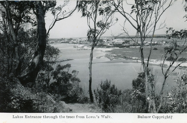
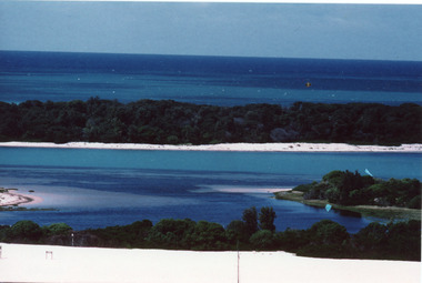
Postcard - Township, 1935 c
Black and white photograph of a view from Kalimna Heights overlooking township. Shows North Arm, Marine Parade, Cunninghame Arm and sand hummocks with Bass Strait in distance. Lakes Entrance Victoriatownship, waterways -
 Lakes Entrance Historical Society
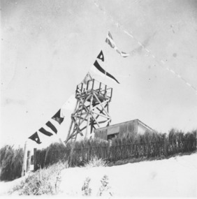
Photograph - Surf Lifesaving, 1938
Black and white photograph timber construction of Surf Lifesaving tower and equipment shed on sand dunes behind brush fence, flags strung from tower flagpole to fence. Lakes Entrance Victoriacommunity services, emergency services, beaches -
 Lakes Entrance Historical Society
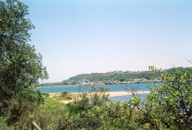
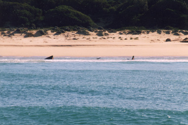
Photograph - Lakes Entrance, Davies, Judy, 2005c
Colour photograph of Jemmys Point, Kalimna Heights, and the Western end of the township, taken from the southern shore of Cunninghame Arm. Small sand spit and natural vegetation in foreground. Lakes Entrance Victoriajetties, waterways, topography, township -
 Lakes Entrance Historical Society
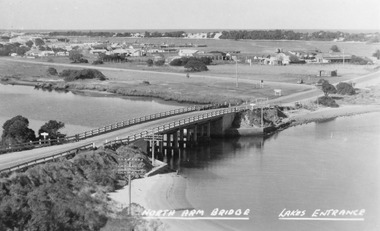
Photograph - North Arm bridge Lakes Entrance Victoria, Bulmer H D, 1945c
Notes: Club Hotel spit has not yet been formed. Also Postcard 8.5 x 13.5Black and white photograph of the North Arm Bridge, It shows the reinforced concrete bridge over the North Arm, and a rear view of other notable buildings. In the background sand hummocks. Lakes Entrance Victoriabridges, topography, township -
 Flagstaff Hill Maritime Museum and Village
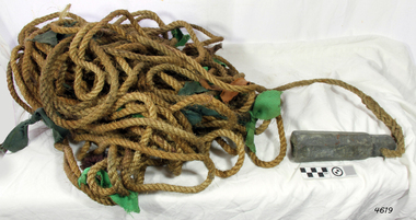
Equipment - Lead line
The lead line or hand lead is a simple navigational instrument used as a depth finder to measure the depth of water under the ship’s keel and to take samples of the sea bed. The long line may be marked at regular intervals with tags of different coloured and textured fabric, such as rope, leather and cloth. Each tag was a code to represent a certain depth. The leadsman’s eyes and hands could distinguish the depth easily as he drew in the lead line, day or night and in poor weather conditions. A standard set of codes for the tags was used so that the depth of the sea could be easily and quickly read. The measurement used was a Fathom, which equals 1.83 metres. The codes were: - 2 fathoms = 2 strips of leather 3 fathoms = 3 strips of leather 5 fathoms = white duck fabric 7 fathoms = red bunting fabric 10 fathoms = leather with a hole 13 fathoms = blue serge fabric 15 fathoms = white duck fabric 17 fathoms = red bunting 20 fathoms = 2 knots The lead weight could be between 7 -14 pounds (3.5 – 6.5kg) and the rope would be approximately 25 fathoms (45m). The hollowed-out end of the weight would hold a stick substance such as tallow or wax, which would pick up samples from the sea bed which would show whether the vessel was close to, or far away from, the shore. The leadsman would stand at the front of the vessel and cast the lead line into the sea. When it hit bottom he would note the tag marker nearest the surface of the water and call out his finding. Then he would haul it up again and examine the kind of matter that adhered to the end of the weight, whether it be sand, mud, gravel, or the colour of it. This information would be given to the ship’s helmsman or navigator and would help indicate the proximity to the land.This handheld lead is an example of early marine navigational equipment used by sailors to travel the seas to measure the depth of the water and sample the nature of the seabed. It helps to understand the history and progress made from the very basic to the sophisticated technology of today.Lead line, sounding line or depth finder. The long length of rope has a heavy lead weight attached to the end. Coloured fabric tags are tied onto the rope at regular intervals, representing different depths. The concave base of weight holds sticky substances such as tallow or beeswax, providing an adhesive surface to collect samples of sea bed like sand, shells or pebbles. flagstaff hill, warrnambool, shipwrecked coast, flagstaff hill maritime museum, maritime museum, shipwreck coast, flagstaff hill maritime village, lead line, depth finder, hand lead, sounding lin, leadsmane, navigation instrument, leadline, hand lead line -
 Stawell Historical Society Inc
Photograph, Lake Lonsdale Sand Bar -- Part of the Water Supply to the Wimmera
Lake Lonsdale Sand Bar. Part of the water Supply to the Wimmera.stawell -
 Latrobe Regional Gallery
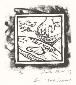
Print, OLIVER, Narelle, Wakati (p) Partulaca Seed for damper 1999, 1999
Linocut printSigned and dated 'Narelle Oliver '99' in lower right under printed image. Edition A/P, lower left under printed image. 'from 'Sand Swimmers" - written lower right corner of page. -
 Phillip Island and District Historical Society Inc.
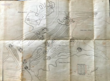
Map, Map of Summerland Golf Course, 15/12/1927
Summerland Estate was created in the 1920s by A.K. T. Sampbell. It consisted of a housing estate, guest house and golf course. This area was acquired and all buildings, roads etc removed by the Victorian Government in the 1980s for a nature reserve for the penguins. This is believed to be the only time in the world when humans have been removed to benefit nature. HistoricalPurple leather covered fold out linen map with hand drawn diagram of the topography, layout of golf holes and club house Broken sand dunes, rough sandy hills, grassy hills and mounds, Swan Lake, Par for nine holes 34, Scratch score for nine holes 36, Drawn by A. Russell 12/12/1927summerland estate, a.k. t. sampbell, map, penguin reserve, summerland golf course -
 Bendigo Military Museum
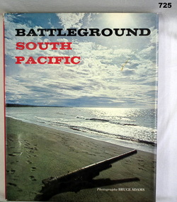
Book, AH and AW Rees, Battleground South Pacific, 1970
Khaki hardcover book with dust jacket. Dust jacket has picture of a beach and sky with a gun barrel on the sand, pointing out to sea. Back cover has three smaller photos of battlefield debris.On second page "Donated by Bgo "Y" Men's Club"books, military battles -
 Federation University Historical Collection
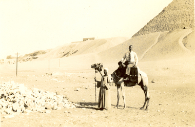
Photograph - Black and White, Frank Wright at the Pyramids, 1940, May 1940
Frank Wright was a renown resident of Smeaton, where he was born. He lived at Laura Villa, and attended Smeaton State School. His father William was a gold miner and his mother's name was Sarah. Their family won many singing and instrumental awards. Frank was tutored by Percy Code and was awarded a gold medal for the highest marks in the ALCM examinations in the British Colonies at the age of seventeen years. He became the Australian Open Cornet Champion by the age of eighteen. A year later, Frank conducted the City of Ballarat Band, and later the Ballarat Soldiers’ Memorial Band. He formed the Frank Wright Frisco Band and Frank Wright and his Coliseum Orchestra. These bands won many South Street awards, and Frank as conductor won many awards in the Australian Band Championship contest. In 1933 Frank Wright sailed to England to conduct the famous St Hilda’s Band and was later appointed Musical Director of the London County Council, where he organized many amazing concerts in parks, in and around the London district. He was made Professor of Brass and Military Band Scoring and conducted at the Guildhall of Music and Drama. Frank was often invited to adjudicate Brass Band Championships around Europe, in Australia, including South Street and in New Zealand. The Frank Wright Medal at the Royal South Street competition is awarded to an individual recognized as making an outstanding contribution to brass music in Australia.Black and white photograph of a man sitting on a camel with the keeper standing at the camel's head. To the left is a pile of rocks and the rest of the background is sand rising to a dune and to the right is part of an Egyptian pyramid. The man is Frank Wright.Written in pencil on back - At the Pyramids, May 1940frank wright, egypt, pyramid, sand dune, camel -
 National Vietnam Veterans Museum (NVVM)
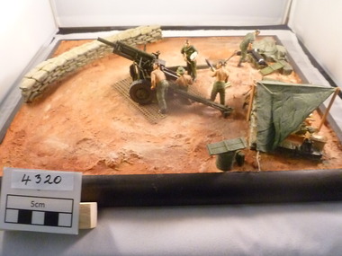
Model - Diorama, Australia guncrew serving 105mm Pack Howitzer
A diorama of some Australian guncrew soldiers working on a 105mm Pack Howitzer. Semi-permanent gun bay with sand bag wall. Crew accommodation (Hutchis) in foreground. Ammunition being prepared by a soldier in the background.105 pack howitzer, diorama -
 Lakes Entrance Historical Society
Photograph - Beaches, 2009
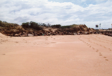
Date made January 2009Colour photograph showing western side of western pier. Rocks extend from end of pier along base of sand dunes, some vegetation on dunes. Signs and lights on piers. Lakes Entrance Victoria topography, beaches -
 Lakes Entrance Historical Society
Photograph - Mary Bernadette, 1990 c
Vessel wrecked 12 March 1985 near Lake Tyers BeachColour photograph of the remains of the fishing boat Mary Bernadette, these remains are usually covered with sand, exposed from time to time. Photograph taken from fishing boat offshore. Lake Tyers Beach Victoriashipwrecks, fishing industry -
 Lakes Entrance Historical Society
Photograph - Hopetoun Channel, Fraser, Ian, 1996c
Colour photograph of Bass Strait, scrub covered coastal dunes, Hopetoun Channel, and southern portion of Rigby Island. Photo taken from sand dunes on Flannagan Island, near Lakes Entrance, Victoria.islands, waterways, topography -
 Lakes Entrance Historical Society
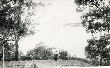
Postcard - The Entrance, Bulmer H D, 1910c
Also black and white enlargement size 16 x 25.| Note on back of postcard, 'Bemm River 16/8/11, To My Dear Elsie, Just a line....., Much love from all, Annie.'Black and white postcard of the man made entrance through the sand hummocks, taken from Jemmys Point. Small boy looking towards entrance, natural vegetation on brow of hill. Lakes Entrance VictoriaLakes Entrance waterways, topography -
 Lakes Entrance Historical Society
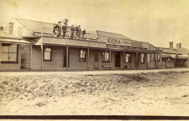
Photograph - Kiora House, 1920c
Also copy enlargement 12 cm x 19 cm Kiora House was purchased by Mrs C Beveridge from Mrs Begg. (Original building, A Murray's store, then Barkes store, before Barkes built near Post Office). House to the left purchased later, balcony built over veranda, this place removed and demolished for family home to be built later.Sepia toned photograph of Kiaora House. Houses on the left and the right. Sandy or Gravel roadway in front of building. Sand at the lake front in foreground of photo. People standing on upper balcony. Lakes Entrance VictoriaKiaora Housearchitecture, township, tourism, room display, local history -
 Lakes Entrance Historical Society
Photograph, Nelson Joan, 1980c
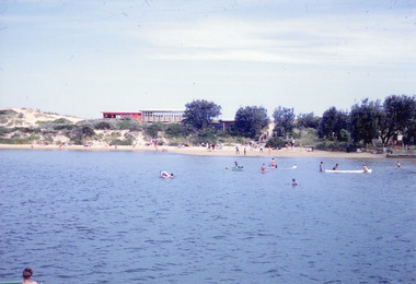
Colour photograph of the beach at the southern shore of Cunninghame Arm. It shows people swimming and paddling, also on the beach, coastal banksia and scrub on sand hummocks, surf lifesaving clubrooms in background. Lakes Entrance Victoriawaterfront, recreation -
 Ithacan Historical Society
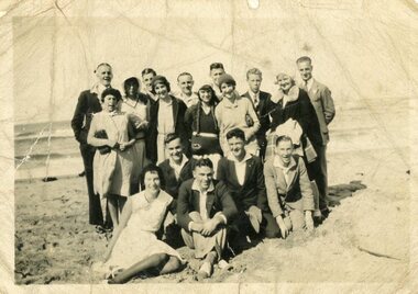
Photograph, At the seaside, c1930s
A black and white photograph with a white border of a group of ten men and seven ladies photographed on a beach. Some are standing while others in the front are sitting on the sand. The sea is lapping onto the shore behind the group. -
 Lakes Entrance Historical Society
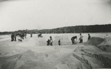
Photograph - Snowy River Marlo Victoria, 1940 c
No 3 in series of fiveBlack and white photograph taken looking back from ocean side showing vegetation in background and workmen with shovels horses and scoops opening an entrance through sand at mouth of Snowy River Marlo Victoriaenvironment, people, public works, waterways -
 Lakes Entrance Historical Society
Photograph - Bullock Island Lakes Entrance, 1995 c
historic Colour photograph of Bullock Island showing the first traffic bridge to the island, Ports buildings, Fishermans Co-op, planted grass and vegetation to bind sandy areas and deposits of sand in shallow North Armislands, waterways, revegetation -
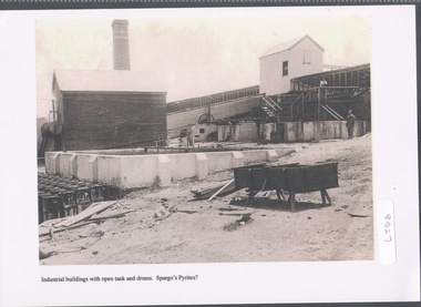 Bendigo Historical Society Inc.
Photograph - Spargo's Pyrites, Specimen Hill
Historic photo of mining at Specimen Hill. After crushing ore, the sand pyrites remaining could be treated to extract even finer gold. The sand was placed in large brick ovens to be roasted, which freed the sand of arsenic, sulphur etc, with the fumes containing these elements released into the atmosphere via a large chimney. Spargo's Pyrite Company operated from about 1870. It closed when there became a shortage of workers during WW1 and appears to have not restarted after the war. Black and white image, possibly copy. Weatherboard building on left hand side, elevated weatherboard building centre with chute descending to lower building. Possibly Spargo's Pyrites works, date unknownspargo's, pyrites -
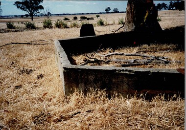 Tatura Irrigation & Wartime Camps Museum
Photograph, Children's Sand Pit Camp 3
Shows the remains of the children's sand pit which was built at Camp 3. Colour photograph on foam backing, of cement remains of a structure foundation with tree right behind and one in distance.camp 3, children's sand pit -
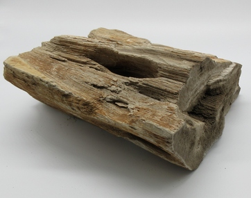 Hume City Civic Collection
Petrified Wood
This piece of petrified wood was found at the sand quarry between Sunbury and Bulla.A petrified piece of wood showing various shades of brown.smith, kevin, john, wood, george evans collection -
 Glenelg Shire Council Cultural Collection
Photograph - Photograph - Dutton Way, Portland, n.d
Port of Portland Authority ArchievesBack: Writing on top left, black pen, only a few words visible-photo cut in half. 52/20 -black pen, top right 4 - pencil, centreport of portland archives, dutton way, erosion, environment, climate change -
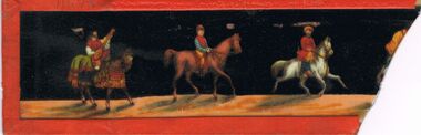 Bendigo Historical Society Inc.
Memorabilia - GLASS ETCHED PLATE
Glass Etched Plate: Black background with three men on horse back riding along a sand coloured road in colourful traditional dress with shadows on the road. The plate has a red taped border. Box 625glass technology, engraved -
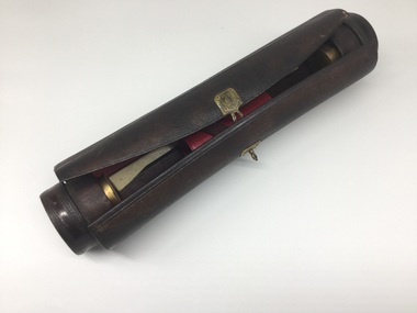 Kew Historical Society Inc
Equipment - Writing Equipment, Writing Case, 19th century, 19th century
Leather pen case, containing writing equipment, possibly used by early surveyor or draftsmanCylindrical leather case containing bottles for ink and sand, holders for pens, nibs, etc. Red leather lining. Ruler, bone-spreader, ivory and brass seal, and pen-holder included. Brass external clasps.writing equipment, writing cases -
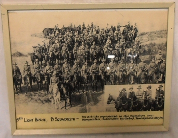 8th/13th Victorian Mounted Rifles Regimental Collection
Photograph, 8th Light Horse B. Squadron, 1940
This photograph is likely to have been taken by a newspaper photographer when visiting the 8th Light Horse Regiment on manoeuvres with the 2nd Cavalry Division at Torquay Victoria in 1940. This assumption is supported by the identification of the districts from which the soldiers are drawn. The Fine studies of citizen soldiers while on manoeuvres in the period immediately preceding phasing out of horses and the transition to mechanised transport.Framed black and white photograph of sixty mounted light horsemen drawn up in massed ranks on a sand hill. Small insert photograph of five light horsemen, probably the squadron officers in lower right corner."8th Light Horse B. Squadron. The districts represented in this Squadron are Wangaratta, Rutherglen, Myrtleford, Tawonga and Moyhu"8th light horse regiment, wangaratta, rutherglen, myrtleford, tawonga, moyhu -
Lakes Entrance Historical Society
Book, Martin Brian, The SS Lady Harriet Barge and other relics Conservation Plan, 1998
A conservation plan directed towards the SS Lady Harriet barge also known as the Stone Barge, positioned on the sand hummocks near the Flagstaff Jetty. The history and use of the vessel is discussed, and recommendations for the short term stabilisation aconservation, ships and shipping -
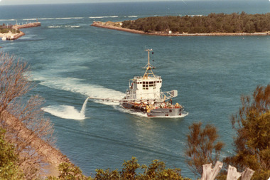 Lakes Entrance Historical Society
Photograph - April Hamer, Fraser, Ian, 1980 c
Colour photograph of the sand dredge, April Hamer, working inside the entrance off Bullock Island. Ocean in background, rock groynes of the entrance visible, a fishing boat coming through the entrance. Lakes Entrance Victoriawaterways, dredging -
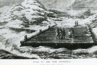 Lakes Entrance Historical Society
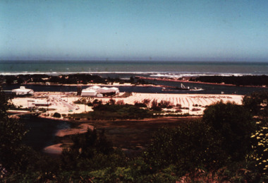
Photograph - Entrance Works, 1880c
Photographed from an early sketchBlack and white photographic postcard showing work in progress on building of entrance piers. On partially built pier, workmen standing on decking, sand dunes and lake at back and Jemmys Point in background. Lakes Entrance VictoriaWork on the new entrance, from an early sketch waterways, public works, piers