Showing 1830 items matching "shire buildings"
-
 Glen Eira Historical Society
Article - Alnwick, Railway Parade,|11-11A,|Murrumbeena
... Buildings Council inviting them to attend a hearing about ‘Alnwick’s’ classification. Almost identical letters, they were sent on 30/09/1988 and 07/02/1989. Kellaway Carlotta Johnson Fay Kaeppel Rose Kaeppel A. J. Caulfield Shire ...Letters and research material regarding ‘Alnwick’, 11-11A Railway Parade, Murrumbeena. First two letters were sent by Fay Johnson to Dr. C. Kellaway at the ministry for planning and environment on 16/06/1988 and 10/08/1988. The latter includes research material regarding the ‘ALNWICK’ house including a brief description of the history of Sir James Patterson, photos of the house and a newspaper extract regarding its sale. The other letters were sent to the secretary of Caulfield Historical Society from the Historic Buildings Council inviting them to attend a hearing about ‘Alnwick’s’ classification. Almost identical letters, they were sent on 30/09/1988 and 07/02/1989.kellaway carlotta, johnson fay, kaeppel rose, kaeppel a. j., caulfield shire council, register of historic buildings, railway parade, shire of caulfield rate book, murrumbeena cres, anzac street, murrumbeena road, murrumbeena station, margaret street, caulfield historical society, historic buildings council, classification, historic buildings, historical societies, local history, dandenong road, fitzroy street, spencer david, ford hazel, patterson james sir, patterson james, burrough naomi, walton anna, murrumbeena, carnegie, politician, parliamentary representatives, slaughterman -
Glen Eira Historical Society
Map - Caulfield Fire Station, No 26, Tree Reserve, Dandenong Road
... Shire of Caulfield... Federal Bank... St James Building...Caulfield East Caulfield Fire Station Dandenong Road Derby Road Racecourse Road Tree Reserve Shire of Caulfield Federal Bank St James Building Society Delves Murchison Fire Stations Map Caulfield Fire Station, No 26, Tree Reserve, Dandenong Road ...A one page photocopy of an undated, unattributed, hand drawn map (200mm x 290mm) of the location on Tree Reserve, Dandenong Road, of the Caulfield Fire station, No 26. The map includes handwritten notes showing various nearby property owners. The file also includes a photocopy of a one page, undated and unattributed printout of the site address and site lease date.caulfield east, caulfield fire station, dandenong road, derby road, racecourse road, tree reserve, shire of caulfield, federal bank, st james building society, delves murchison, fire stations -
Glen Eira Historical Society
Document - Caulfield Fire Station, No 26, Tree Reserve, Dandenong Road
... Shire of Caulfield... Tree Reserve... Caulfield Fire Station... RS Anderson and Son... Fire stations... Legal Documents... Lloyd C D... Jowett F... Delves Catherine ... Catani C... Federal Building...Caulfield East Shire of Caulfield Tree Reserve Caulfield Fire Station RS Anderson and Son Fire stations Legal Documents Lloyd C D Jowett F Delves Catherine Catani C Federal Building Society St James Building Society Nathan Philip Trustees of the late John Nathan Adams J Bates J Document Caulfield Fire Station, No 26, Tree Reserve, Dandenong Road ...A three page photocopy of a handwritten memorandum of agreement dated 11/10/1894 between the municipalities of Caulfield and Malvern and the Metropolitan Fire Brigades Board consenting to the erection of a fire station on Tree Reserve. Also a three page photocopy of a handwritten agreement dated 11/10/1894 between owners of properties in the neighbourhood of the junction of Dandenong Road and Waverly Road and the Metropolitan Fire Bridgades Board to allow the Board to erect and use a fire station on Tree Reserve in Dandenong Road. The agreement was signed by the property owners.caulfield east, shire of caulfield, tree reserve, caulfield fire station, rs anderson and son, fire stations, legal documents, lloyd c d, jowett f, delves catherine , catani c, federal building society, st james building society, nathan philip, trustees of the late john nathan, adams j, bates j -
Glen Eira Historical Society
Document - Roseneath, Nepean Highway, 31, Elsternwick
... Georges Road Caulfield South Shire of Caulfield East St. Kilda Riding Historic Buildings Register National Trust Register National Estate Register Italianate Style Architectural Styles Architectural Features Mansions Brick Houses Verandahs Cast Iron Work Bluestone Bay Windows Land Subdivisions Merchants Judges Leases Councillors Document Roseneath, Nepean Highway, 31, Elsternwick ...A photocopy of a Caulfield Conservation Study conducted in January 1995 by historian Andrew Ward of the house Roseneath named thus by 1904. The document includes a photocopied photograph of the front façade, although the features are unclear. The document, which includes a bibliography, details the history of Roseneath, including owners and occupiers, as well as the architectural features of significance and historical value.ward andrew, millar william, boyle andrew, worthington george, tulloch annie, cross anastasia, meek alex, caulfield, roseneath, elsternwick, nepean highway, mcmillan street, point nepean road, rusden street, cumbernauld, hawthorn road, glenmoore, st. georges road, caulfield south, shire of caulfield, east st. kilda riding, historic buildings register, national trust register, national estate register, italianate style, architectural styles, architectural features, mansions, brick houses, verandahs, cast iron work, bluestone, bay windows, land subdivisions, merchants, judges, leases, councillors -
 Bendigo Historical Society Inc.
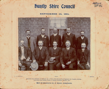
Photograph - HUNTLY SHIRE COUNCIL, 1911
... building. Five men standing behind five men seated (see 'Inscriptions'). Mounted on fawn board. Inscriptions' Front 'MP114, GP46', 'Huntly Shire Council, September 14, 1911', 'Photo WH Robinson, Bendigo'. ...History House 11 Mackenzie Street Bendigo goldfields PERSON Group huntly shire council WM H Robinson, Mundy St Bendigo Black and white photograph taken outside in front of a brick building. ...Black and white photograph taken outside in front of a brick building. Five men standing behind five men seated (see 'Inscriptions'). Mounted on fawn board. Inscriptions' Front 'MP114, GP46', 'Huntly Shire Council, September 14, 1911', 'Photo WH Robinson, Bendigo'. Back row: Crs Matthews, E Buckland, Mr A Fulton (Shire Secretary and Engineer), Crs Coughlin, Sullivan'. Front row: Crs Peatling, Walter, G Simmie (President),Sharkey, Carr', 'With the President's (Cr G Simmie), compliments'. On back RHSV Stamp 'WM H Robinson, Photographer, Mundy St, Bendigo', 'Bendigo Historical Society (Inc.) typed on white paper, glued to board.WM H Robinson, Mundy St Bendigoperson, group, huntly shire council -
 Bendigo Historical Society Inc.
Photograph - FERNIHURST ESTATE
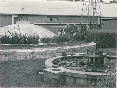
... Building fernihurst estate J. Evans ? black and white photo: farm yard scene, galvanised bui,lding with window and door ( partly obscured by well cover ) base of windmill on right. Lily pond with frog decorations in foreground . Poperty of J. Evans, in Shire ...black and white photo: farm yard scene, galvanised bui,lding with window and door ( partly obscured by well cover ) base of windmill on right. Lily pond with frog decorations in foreground . Poperty of J. Evans, in Shire of Korong ( nr Boort ) Written on back in pen ' J,. Evans, Fernihurst Estate, Fernihurst 'J. Evans ?place, building, fernihurst estate -
 Bendigo Historical Society Inc.
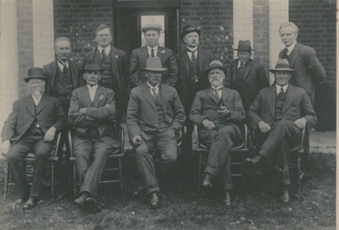
Photograph - MALE PORTRAIT, c.1920
... Shire early 1900's. Photo shows eleven adult males, five seated. Four visible watch chains, two floral buttonholes, brick walled building in background. ...Shire early 1900's. Photo shows eleven adult males, five seated. Four visible watch chains, two floral buttonholes, brick walled building in background. ...Black and white photograph of councillors and officers of Strathfieldsaye Shire early 1900's. Photo shows eleven adult males, five seated. Four visible watch chains, two floral buttonholes, brick walled building in background. Lapel badge on gent, back row, 2nd from left is similar to 1914 - 18 WW1 badge therefore photo is later. Inscriptions - on back: Stamp printed 'F Harrison, Photographer, 151? Lyttleton Terrace, Bendigo'. In blue ballpoint ink 'Strathfieldsaye Shire Council from Mrs Lowndes, McIvor Road. Inclusions: typed caption 'Councillors and officers of Strathfieldsaye Shire early in the twentieth century. If any reader can assist in identifying these men it would be appreciated. Photographed by F Harrison, Bendigo Historical Society. History of object: previous Acc. No. 'GP 42'F Harrisonperson, group, councillors strathfieldsaye -
 The Beechworth Burke Museum
Photograph, c. 1910
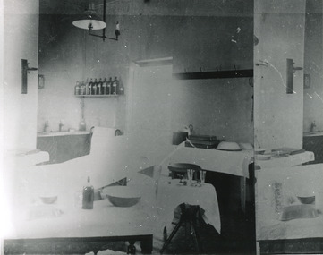
... The hospital is made up of a number of buildings, landscaping, ha-ha, workshops, laundry, administrative facilities and farmland, it was constructed in 'Italianate' style by a team of up to two hundred and fifty workers (Woods p. 122). The asylum was established in response to the need for the regional shire...The hospital is made up of a number of buildings, landscaping, ha-ha, workshops, laundry, administrative facilities and farmland, it was constructed in 'Italianate' style by a team of up to two hundred and fifty workers (Woods p. 122). The asylum was established in response to the need for the regional shire ...Taken approximately 1910, this black and white photograph shows the interior of the surgery and consulting rooms at the Mayday Hills mental hospital known at that time as a lunatic asylum in Beechworth. Mayday Hills Hospital, then known as the Beechworth Lunatic Asylum was constructed between 1864-67 designed by The Public Works Department. The hospital is made up of a number of buildings, landscaping, ha-ha, workshops, laundry, administrative facilities and farmland, it was constructed in 'Italianate' style by a team of up to two hundred and fifty workers (Woods p. 122). The asylum was established in response to the need for the regional shire to locally care for those particularly affected by their time working the Ovens goldfield during the Indigo Shire gold rush era where poor living conditions and isolation were significantly affecting the welfare of a great many people through poverty and lack of resources. The gaol and orphan labour systems were not able to effectively support to give housing, rehabilitation and ongoing care for the mentally ill, and transporting to Melbourne by waggon was a time consuming and counter-productive solution when the metro facilities were already overcrowded. According to Woods (A Titan's Field p. 122), between 1901 and 1911 a large percentage (thirty five percent in 1901 and twenty four in 1911) of the Beechworth population were either patients or inmates of Beechworth institutions, Mayday Hills accounted for some six hundred and seventy four patients in 1901, Beechworth's Mayday Hills was chosen as the site of Victoria's newest asylum, at the time, due to the landscape and altitude. The hilltop atmosphere and the native fauna, it was argued, would assist in the cure of the patients kept at the hospital (Wood 1985, 122). The positioning of the hospital had a beneficial effect on the rural town and the large volume of people living at the hospital and contributing to this population growth is counted as reason for the survival of Beechworth as a regional township. Mayday Hills continued to function as a mental hospital up until 1995 when it was sold to LaTrobe university. The building and grounds are listed on the Victorian Heritage Register under criterion A, B, D, E and F. Although grainy, the image gives a good indication of a functioning interior space of a surgery and consulting room at Mayday Hills in the early 1900's, from which we might interpret (from the types of tools and furniture present), the medical practices being performed at the time.Black and white rectangular photographmedical, asylum, surgery, hospital, beechworth, mayday hills, mayday hills asylum, mayday hills hospital, mental hospital, beechworth lunatic asylum, beechworth institutions, social welfare, public works department, consulting room -
 The Beechworth Burke Museum
Photograph - Postcard, George Rose, c. 1910
... The hospital is made up of a number of buildings, landscaping, ha-ha, workshops, laundry, administrative facilities and farmland, it was constructed in 'Italianate' style by a team of up to two hundred and fifty workers (Woods p. 122). The asylum was established in response to the need for the regional shire...The hospital is made up of a number of buildings, landscaping, ha-ha, workshops, laundry, administrative facilities and farmland, it was constructed in 'Italianate' style by a team of up to two hundred and fifty workers (Woods p. 122). The asylum was established in response to the need for the regional shire ...Produced c. 1910 by The Rose Stereograph co. This colourised photographic postcard shows the exterior of the administrative buildings at Mayday Hills mental hospital with three young boys in the foreground. This postcard forms part of the extensive Rose Series. (P. 4689) of postcards being produced by the Rose Stereograph co. which depicted landmarks from across Australia. Despite the early date attributed to this image, according to Walsh dates from this series place the postcards being produced typically between 1920-54. Mayday Hills Hospital, then known as the Beechworth Lunatic Asylum was constructed between 1864-67 designed by The Public Works Department. The hospital is made up of a number of buildings, landscaping, ha-ha, workshops, laundry, administrative facilities and farmland, it was constructed in 'Italianate' style by a team of up to two hundred and fifty workers (Woods p. 122). The asylum was established in response to the need for the regional shire to locally care for those particularly affected by their time working the Ovens goldfield during the Indigo Shire gold rush era where poor living conditions and isolation were significantly affecting the welfare of a great many people through poverty and lack of resources. The gaol and orphan labour systems were not able to effectively support to give housing, rehabilitation and ongoing care for the mentally ill, and transporting to Melbourne by waggon was a time consuming and counter-productive solution when the metro facilities were already overcrowded. According to Woods (A Titan's Field p. 122), between 1901 and 1911 a large percentage (thirty five percent in 1901 and twenty four in 1911) of the Beechworth population were either patients or inmates of Beechworth institutions, Mayday Hills accounted for some six hundred and seventy four patients in 1901, Beechworth's Mayday Hills was chosen as the site of Victoria's newest asylum, at the time, due to the landscape and altitude. The hilltop atmosphere and the native fauna, it was argued, would assist in the cure of the patients kept at the hospital (Wood 1985, 122). The positioning of the hospital had a beneficial effect on the rural town and the large volume of people living at the hospital and contributing to this population growth is counted as reason for the survival of Beechworth as a regional township. Mayday Hills continued to function as a mental hospital up until 1995 when it was sold to LaTrobe university. The building and grounds are listed on the Victorian Heritage Register under criterion A, B, D, E and F. Through the colourisation of the photograph and through the unusual choice of the subject matter being used as a postcard, we can get a good indication of aesthetic interests of the time.Rectangular coloured photograph printed as postcardObverse: Beautiful / Beechworth / (Vic.) / 1800 ft. / above / Sea / Level / - / Asylum / for / insane / (Front / View) / Copyright. / F. / Foxcroft / Photo Reverse: 1997.2454 / Postcard / THIS / SPACE / MAY / BE / USED / FOR / CORRESPONDENCE: / THIS / SPACE / FOR / NAME / AND / ADDRESS / STAMPpostcard, rose series, mayday hills hospital, mayday hills, beechworth lunatic asylum, photographic postcard, george rose, the rose stereograph co., social welfare, welfare services, ovens goldfield, lunatic asylum, the public works department, australian landmark, regional shire, indigo shire council, gold rush, beechworth institution, victorian heritage register -
 The Beechworth Burke Museum
Photograph - Photographs, E. Yellard, c. 1950's
... building...black and white photographs...Beechworth...Mental Hospital...Beechworth Mental Hospital...Mayday Hills...cars...1950...E. Yellard...The Public Works Department...Public Works Department...hospital...Mayday Hills Hospital...Beechworth Lunatic Asylum...Lunatic Asylum...Asylum...Ovens goldfield...Indigo Shire...The hospital is made up of a number of buildings, landscaping, ha-ha, workshops, laundry, administrative facilities and farmland, it was constructed in 'Italianate' style by a team of up to two hundred and fifty workers (Woods p. 122). The asylum was established in response to the need for the regional shire...The hospital is made up of a number of buildings, landscaping, ha-ha, workshops, laundry, administrative facilities and farmland, it was constructed in 'Italianate' style by a team of up to two hundred and fifty workers (Woods p. 122). The asylum was established in response to the need for the regional shire ...Two rectangular black and white photographs of the Beechworth Mental Hospital (Mayday Hills) administrative building showing the left and right hand sides of the exterior building with three cars parked in driveway turning circle in the foreground taken in the 1950's by E. Yellard. Mayday Hills Hospital, originally known as the Beechworth Lunatic Asylum was constructed between 1864-67 designed by The Public Works Department. The hospital is made up of a number of buildings, landscaping, ha-ha, workshops, laundry, administrative facilities and farmland, it was constructed in 'Italianate' style by a team of up to two hundred and fifty workers (Woods p. 122). The asylum was established in response to the need for the regional shire to locally care for those particularly affected by their time working the Ovens goldfield during the Indigo Shire gold rush era where poor living conditions and isolation were significantly affecting the welfare of a great many people through poverty and lack of resources. The gaol and orphan labour systems were not able to effectively support to give housing, rehabilitation and ongoing care for the mentally ill, and transporting to Melbourne by waggon was a time consuming and counter-productive solution when the metro facilities were already overcrowded. According to Woods (A Titan's Field p. 122), between 1901 and 1911 a large percentage (thirty five percent in 1901 and twenty four in 1911) of the Beechworth population were either patients or inmates of Beechworth institutions, Mayday Hills accounted for some six hundred and seventy four patients in 1901, Beechworth's Mayday Hills was chosen as the site of Victoria's newest asylum, at the time, due to the landscape and altitude. The hilltop atmosphere and the native fauna, it was argued, would assist in the cure of the patients kept at the hospital (Wood 1985, 122). The positioning of the hospital had a beneficial effect on the rural town and the large volume of people living at the hospital and contributing to this population growth is counted as reason for the survival of Beechworth as a regional township. According to the Victorian Heritage database, during the period 1921-1950 Mayday Hills underwent some modernisation by Public Works Department architect Percy Everett which included a nurses' hostel and new ward which were further developed and continued to function as a mental hospital up until 1995 when it was sold to LaTrobe university. The building and grounds are listed on the Victorian Heritage Register under criterion A, B, D, E and F.These photographs give a good indication of the ongoing use of Mayday Hills from its original establishment in the 1860's through to almost one hundred years later when these photographs were taken. The clarity of the images combined with the style and make of the cars in the foreground give a good indication of the time period and show the continued use and need for the facility over the years. Through images of building facades such as these, we might gain fuller understanding of the structural and aesthetic characteristics to be used in any future development or restorative work.2 x black and white rectangular photographs [copies] printed on Ilford photographic paper8688.1 reverse: Beechworth / Mental / Hospital / 80% 19cm / 12 cm / 80% / 728 / New / Print / BMM / 8688.1 / E. / Yellard / [Stamped : ILFORD] 8688.2 reverse: Beechworth / Mental / Hospital / E. / Yellard / BMM / 8688.1 / [Stamped : ILFORD]administrative building, black and white photographs, beechworth, mental hospital, beechworth mental hospital, mayday hills, cars, 1950, e. yellard, the public works department, public works department, hospital, mayday hills hospital, beechworth lunatic asylum, lunatic asylum, asylum, ovens goldfield, indigo shire, indigo shire gold rush -
 The Beechworth Burke Museum
Photograph, c1900
... buildings in Bridge Street of Newtown, Beechworth. Beechworth New Town Newtown Newtown Beechworth local business Mackenzie Family Store Mackenzie's Family Store Mackenzie grain store Bridge Ford Steet High Street colonial australia australian gold rushes mining technology beechworth historic district indigo gold trail migration indigo shire McKenzie and Sons Grainstore McKenzie Family Store McKenzie Newtown Bridge Reverse: 6980/ PH 118/ 1998.00059/ Black and white rectangular photograph printed on paper Photograph Photograph ...Believed to have been taken sometime between 1858 and 1908, featuring a man with moustache, dressed in hat and long riding coat, seated on a bob-tailed horse, is stopped in the middle of a wide dirt road in Beechworth. He is outside a row of businesses, including R.McKenzie & Sons Grain Store and Mackenzie Family Store (Wholesale & Retail Est. 1855), along a sloping hill. Behind the main rider are a parked horse and laden two-wheeled cart backed up directly outside the grain store's verandah, and another man is driving a horse and four-wheeled wagon forward towards them. At the bottom of the hill is a bridge (Newtown Bridge) with forked road on the far side, leading to a number of houses on both sides of another hill. This image is looking down Bridge Street, Newtown, Beechworth and across to Ford Street (left) and High Street (right). Road-making was a focus of town development during the 1850s, and the wide streets were created on the instructions of the surveyor-general to be between sixty-six and ninety-nine feet wide to give the town a pleasing aspect.This photograph is important in showing the development and expansion of the various businesses and buildings in Bridge Street of Newtown, Beechworth. Black and white rectangular photograph printed on paperReverse: 6980/ PH 118/ 1998.00059/beechworth, new town, newtown, newtown beechworth, local business, mackenzie family store, mackenzie's family store, mackenzie, grain store, bridge, ford steet, high street, colonial australia, australian gold rushes, mining technology, beechworth historic district, indigo gold trail, migration, indigo shire, mckenzie and sons grainstore, mckenzie family store, mckenzie, newtown bridge -
 The Beechworth Burke Museum
Photograph, c1999-2000
... shire...beechworth athanaeum...beechworth library...beechworth historic building...This photograph captures this distinctive character and may be compared and studied alongside other images of historic buildings in the Burke Museum Photographic Collection. burke museum indigo shire beechworth athanaeum beechworth library beechworth historic building historic precinct burke museum exhibition from the liedertafel to the skating rink honey-coloured local granite robert o'hara burke victorian gold fields historic towns in victoria colonial australia liedertafel colonial entertainments beechworth brass band historic victorian architecture australia's oldest regional museum burke and wills expedition first europeans to cross australia yound mens associations beechworth tourism things to see in beechworth beechworth historic trail young men's associations Reverse: 7031 / Label: Burke Museum / 1999/2000 / Rectangular colour photograph printed on photographic paper. ...This photograph taken c1999/2000, depicts the Burke Museum’s granite façade and vestibule entrance. The museum's large red door is closed and there is a white sign is attached to the door. The museum site dates to the 1857 founding of the Beechworth Public Library and Athenaeum by a newly formed Young Men's Association (YMA). In 1863 the museum was dedicated as a memorial to former Beechworth police superintendent (1854-1858) and explorer Robert O’Hara Burke, following Burke’s death from malnutrition on the Burke and Wills expedition in 1861. Funded by the Victorian Government and the Royal Society of Victoria, the officially titled 'Victorian Exploring Expedition' was tasked with being the first European party to traverse Australia from south to north. The Burke Museum holds objects from the famous expedition and explores the multi-layered history of Beechworth and surrounds from the gold rush era to the present.This photograph is historically significant for its depiction of the Burke Museum c1999/2000. The Burke Museum is Australia’s oldest regional museum and part of Beechworth's Historic and Cultural Precinct, one of Australia’s best preserved historic-town sites and a popular tourist destination. Once the government centre for a vast gold fields region, this collection of nationally significant buildings tells the story of how Australia grew and prospered. The frequent use of honey-coloured local granite as a building material, which can be seen in the museum's fabric, gives Beechworth’s historic buildings a distinct and cohesive local character. This photograph captures this distinctive character and may be compared and studied alongside other images of historic buildings in the Burke Museum Photographic Collection.Rectangular colour photograph printed on photographic paper.Reverse: 7031 / Label: Burke Museum / 1999/2000 /burke museum, indigo shire, beechworth athanaeum, beechworth library, beechworth historic building, historic precinct, burke museum exhibition, from the liedertafel to the skating rink, honey-coloured local granite, robert o'hara burke, victorian gold fields, historic towns in victoria, colonial australia, liedertafel, colonial entertainments, beechworth brass band, historic victorian architecture, australia's oldest regional museum, burke and wills expedition, first europeans to cross australia, yound mens associations, beechworth tourism, things to see in beechworth, beechworth historic trail, young men's associations -
 The Beechworth Burke Museum
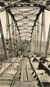
Photograph, c. 1927 - 1930
... Bethanga Bridge is of historical significance to the Indigo Shire for its associations with the construction of Hume Dam, its associations with the River Murray Waters Agreement and the River Murray Commission, and illustration of the needs and influence of the farming communities along the river in this area - particularly in relation to the building of the Weir. ...Taken during the construction of the Bethanga Bridge (1927-1930), this sepia photograph shows a view of the incomplete bridge taken from inside the structure and looking down the span of the bridge from where the photographer stands. The photograph depicts an incomplete deck, with loose-looking wooden planks/panels lain along the centre in groups of three. Once complete, the original decking of the bridge was made of timber before being replaced by cement in 1961 (Victorian Heritage Database).Bethanga Bridge is of historical significance to the Indigo Shire for its associations with the construction of Hume Dam, its associations with the River Murray Waters Agreement and the River Murray Commission, and illustration of the needs and influence of the farming communities along the river in this area - particularly in relation to the building of the Weir. It also represents the collaboration between New South Wales and Victoria on a large infrastructure project, being the only built structure shared by both New South Wales and Victoria due to its location. also reflecting on the Shire's geographical closeness to this neighboring state. This photograph is part of a series that documents the construction of this well-known heritage site of significance to the Indigo Shire. It reflects upon a period of growth and change in the area.Sepia, rectangular photograph printed on matt photographic paper, unmountedReverse: 1997.3190 / Another snap of the bridge. taken on the bridge showing huge steel sides / 84-19-4 / V [in circle] 354 / KODAK PRINTbethanga bridge, hume dam, bridges album, construction, road construction, hume weir -
 The Beechworth Burke Museum
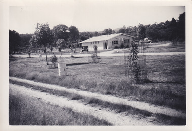
Photograph, 1960s
... This photograph was taken in the 1960s at Lake Sambell Caravan Park and visible in the photograph are individual caravan sites with electricity outlets, a large single-story building with a caravan park banner, dirt roads, a freestanding message board, and a parked car. Lake Sambell Caravan Park opened in 1959 owing to the work of R.E. Carter, Beechworth Shire...The Beechworth Burke Museum Loch Street Beechworth high-country This photograph was taken in the 1960s at Lake Sambell Caravan Park and visible in the photograph are individual caravan sites with electricity outlets, a large single-story building with a caravan park banner, dirt roads, a freestanding message board, and a parked car. Lake Sambell Caravan Park opened in 1959 owing to the work of R.E. Carter, Beechworth Shire ...This photograph was taken in the 1960s at Lake Sambell Caravan Park and visible in the photograph are individual caravan sites with electricity outlets, a large single-story building with a caravan park banner, dirt roads, a freestanding message board, and a parked car. Lake Sambell Caravan Park opened in 1959 owing to the work of R.E. Carter, Beechworth Shire engineer from 1954-63. Carter advocated for improvements to the lake and surrounding area in order to encourage tourism in Beechworth. The opening of the caravan park was part of many improvements to Lake Sambell made in this period by Carter including: the swimming pool in 1961, water skiing and boating facilities, and increased lake surface in 1964. These improvements were financed mainly by grants from the Tourist Development Authority. The popularity of caravanning in Australia exploded during this post-war period of the late 1950s and 1960s. This popularity was driven by multiple factors, including: the stopping of fuel rations, the accessibility of car ownership through the manufacturing of affordable cars, technological developments in caravan design, and the increase in prosperity and leisure time for many Australians. Facilities such as electrical outlets to power caravans are present in this photograph of Lake Sambell Caravan Park. Lake Sambell is an artificial lake that was developed on the previous site of the Rocky Mountain Mining Company workings and was officially opened by Minister for Lands, Mr Baily, on October 5, 1928. The disused and unattractive remains of the mine were converted into a recreational area intended for swimming, boating, and fishing. The lake is named after Mr L.H. Sambell, shire engineer and secretary of the Forward Beechworth Committee, who advocated for the enhancement of Beechworth into a tourist destination and was central to the planning and establishment of the lake. This photograph is of historical and social significance in providing insight into caravanning during the 1960s in Australia. Caravanning was extremely popular during the 1960s in Australia due to multiple social and economic factors including the stopping of fuel rations, the accessibility of car ownership through the manufacturing of affordable cars, technological developments in caravan design, and the increase in prosperity and leisure time for many Australians.Black and white rectangle photograph printed on photographic paper and unmounted.Reverse: 3536/ [logo back printing: KODAK/ VELOX/ PAPER] / C798 lake sambell caravan park, lake sambell, caravanning 1960s, caravan park, rocky mountain mining company, kodak velox paper, r.e. carter, l.h. sambell, caravan electricity outlets, tourist development authority, post-war prosperity, forward beechworth committee, lake sambell boating, lake sambell swimming pool, lake sambell fishing, artificial lake, travel 1960s, recreation 1960s -
 The Beechworth Burke Museum
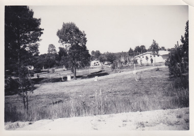
Photograph, 1960s
... This photograph was taken in the 1960s at Lake Sambell Caravan Park, visible in the photograph are individual caravan sites with electricity outlets, a large single-story building, a parked car, and two caravans partially obstructed by trees. Lake Sambell Caravan Park opened in 1959 owing to the work of R.E. Carter, Beechworth Shire...The Beechworth Burke Museum Loch Street Beechworth high-country This photograph was taken in the 1960s at Lake Sambell Caravan Park, visible in the photograph are individual caravan sites with electricity outlets, a large single-story building, a parked car, and two caravans partially obstructed by trees. Lake Sambell Caravan Park opened in 1959 owing to the work of R.E. Carter, Beechworth Shire ...This photograph was taken in the 1960s at Lake Sambell Caravan Park, visible in the photograph are individual caravan sites with electricity outlets, a large single-story building, a parked car, and two caravans partially obstructed by trees. Lake Sambell Caravan Park opened in 1959 owing to the work of R.E. Carter, Beechworth Shire engineer from 1954-63. Carter advocated for improvements to the lake and surrounding area in order to encourage tourism in Beechworth. The opening of the caravan park was part of many improvements to Lake Sambell made in this period by Carter including: the swimming pool in 1961, water skiing and boating facilities, and increased lake surface in 1964. These improvements were financed mainly by grants from the Tourist Development Authority. The popularity of caravanning in Australia exploded during this post-war period of the late 1950s and 1960s. This popularity was driven by multiple factors, including: the stopping of fuel rations, the accessibility of car ownership through the manufacturing of affordable cars, technological developments in caravan design, and the increase in prosperity and leisure time for many Australians. Facilities such as electrical outlets to power caravans are present in this photograph of Lake Sambell Caravan Park. Lake Sambell is an artificial lake that was developed on the previous site of the Rocky Mountain Mining Company workings and was officially opened by Minister for Lands, Mr Baily, on October 5, 1928. The disused and unattractive remains of the mine were converted into a recreational area intended for swimming, boating, and fishing. The lake is named after Mr L.H. Sambell, shire engineer and secretary of the Forward Beechworth Committee, who advocated for the enhancement of Beechworth into a tourist destination and was central to the planning and establishment of the lake. This photograph is of historic and social significance in documenting the enhancement of the Lake Sambell area overseen by R.E. Carter and providing insight into caravanning during the 1960s in Australia. Caravanning was extremely popular in Australia during the late 1950s and 60s due to multiple social and economic factors including the stopping of fuel rations, the accessibility of car ownership through the manufacturing of affordable cars, technological developments in caravan design, and the increase in prosperity and leisure time for many Australians. Black and white rectangle photograph printed on photographic paper and unmounted.Reverse: 3538/ [logo back printing KODAK/ VELOX/ PAPER] / C798lake sambell caravan park, lake sambell, lake sambell 1960s, lake sambell fishing, lake sambell boating, lake sambell swimming pool, r.e. carter, l.h. sambell, tourist development authority, caravanning 1960s, caravan electricity outlets, caravan park, forward beechworth committee, rocky mountain mining company, lake caravan park, caravan mid 20th century, beechworth tourism, travel in the 1960s, holiday 1960s -
 The Beechworth Burke Museum
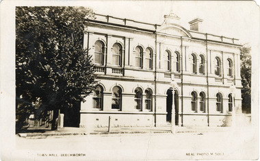
Photograph - Postcard, Town Hall Beechworth, c1910
... Originally the building was used as the Shire Offices but also doubled as a fire station and a courthouse, with still surviving cells underneath. ...The buildings are also registered by the National Estate, the National Trust and protected by Indigo Shire Council’s Planning Scheme. ...Beechworth Town Hall was designed by architects J.J. Coe and Thomas Dalziel and is dated to 1859. The building was made of granite and constructed to local builders Donald and William Fiddes. The original front to the building was replaced by a two story facade in 1889 designed by George Jobbins and built by Thomas Sandham according to a plaque on the front. The Town Hall is remarkable for its vaulted ceilings and columns. Originally the building was used as the Shire Offices but also doubled as a fire station and a courthouse, with still surviving cells underneath. Among the inmates was notorious bushranger Harry Power who was originally transported to Van Dieman’s Land for stealing a pair of shoes. He gained his freedom six years later but spent time in and out of gaol for the rest of his life for a variety of offences including a number of armed robberies. The Town Hall is now home to the Visitor Information Centre which helps visitors with amongst other things, accommodation, tours, event enquiries, and is the commencement point for Precinct walking tours. The Beechworth Town Hall is one of five distinctive granite buildings on Ford Street that comprise the Justice Precinct. It is of considerable historical significance as activity on the site dates from Australia’s gold rush period and was the administrative centre for north-eastern Victoria. The building has seen continual use from 1858 as an important public building and displays many aspects of the history of law enforcement in Victoria. The building is also of substantial architectural significance for its construction from local honey coloured granite, which also showcases early stone masonry techniques and craftsmanship. The Precinct is listed on the Victorian Heritage register and is protected by Heritage Victoria under the Victorian Heritage Act 2017. The buildings are also registered by the National Estate, the National Trust and protected by Indigo Shire Council’s Planning Scheme. Black and White rectangular postcard printed on cardReverse: 1906-1910?beechworth, beechworth town hall, town hall, jj coe, thomas dalziel, granite, beechworth historic building, courthouse, cells, geoge jobbins, thomas sandham, 1859, 1889, walking tours, beechworth historic precinct, historic precinct, harry power, bushranger, australian bushrangers, van dieman's land, transportation, armed robberies -
 The Beechworth Burke Museum
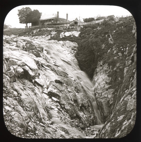
Photograph - Lantern Slide, c1900
... shire...north-east victoria...spring creek falls...beechworth gorge...louis chevalier...nicholas chevalier...lumber industry...timber industry...1850s...construction...building...Burke Museum Beechworth Lantern Slide Slide Glass Slide Plate Burke Museum Collection Photograph Monochrome indigo shire north-east victoria spring creek falls beechworth gorge louis chevalier nicholas chevalier lumber industry timber industry 1850s construction building mill mills waterfall Thin translucent sheet of glass with a square image printed on the front and framed in a black backing. ...This image shows the gorge adjacent to Beechworth in approximately 1900. Although the exact location of the photograph is yet to be determined, the present-day Beechworth Gorge Walk includes views of the Cascades at the point at which Spring Creek flows into the valley on the level below. Gold-sluicing techniques in use in the town during periods of active gold extraction may have altered the landscape since the photograph was taken, however. In the 1850s a mill was built at the top of the Spring Creek falls by Russian-born Louis Chevalier, brother of artist Nicholas Chevalier. The mill supplied the town with lumber that supported the town's initial construction boom. Lantern slides, sometimes called 'magic lantern' slides, are glass plates on which an image has been secured for the purpose of projection. Glass slides were etched or hand-painted for this purpose from the Eighteenth Century but the process became more popular and accessible to the public with the development of photographic-emulsion slides used with a 'Magic Lantern' device in the mid-Nineteenth Century. Photographic lantern slides comprise a double-negative emulsion layer (forming a positive image) between thin glass plates that are bound together. A number of processes existed to form and bind the emulsion layer to the base plate, including the albumen, wet plate collodion, gelatine dry plate and woodburytype techniques. Lantern slides and magic lantern technologies are seen as foundational precursors to the development of modern photography and film-making techniques.This glass slide is significant because it provides insight into Beechworth's built environment and natural landscape in the early Twentieth Century, around the time of Australia's Federation. It is also an example of an early photographic and film-making technology in use in regional Victoria in the time period.Thin translucent sheet of glass with a square image printed on the front and framed in a black backing. It is held together by metals strips to secure the edges of the slide.burke museum, beechworth, lantern slide, slide, glass slide, plate, burke museum collection, photograph, monochrome, indigo shire, north-east victoria, spring creek falls, beechworth gorge, louis chevalier, nicholas chevalier, lumber industry, timber industry, 1850s, construction, building, mill, mills, waterfall -
 The Beechworth Burke Museum
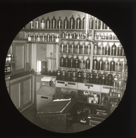
Photograph - Lantern Slide, c1900
... Burke Museum Beechworth Lantern Slide Slide Glass Slide Plate Burke Museum Collection Photograph Monochrome hilda dow roy dow chiltern pharmacy dow's pharmacy chiltern indigo shire north east victoria history of pharmacies women in pharmacy women in medicine women in business david mcewan john mcewan national trust national trust victoria north-east victoria national trust heritage buildings industrial heritage helene grey pharmaceutical society of victoria victorian college of pharmacy country women's association caroline copp royal melbourne hospital red cross infant welfare association Thin translucent sheet of glass with a circular image printed on the front and framed in a black backing. ...Chiltern Pharmacy, now called Dow's Pharmacy, opened in 1859 at a time when the township of Chiltern was experiencing a second-wave gold rush that redistributed the balance of commercial and social activity in the region. David McEwan, father of Prime Minister John McEwan, was one of the first pharmacists practicing at the business. It was purchased in 1929 by pharmacist Hilda Dow who ran the business with her apprentice and husband, Roy Dow, until they closed the business in 1968. In 1988, after founding the North East branch of the National Trust, the Dows donated the premises with its entire fittings and stock. Some of the more than 4,000 items in stock at the time of closure in 1968 were present in the shop when the Dows took charge in 1929 and date to the late Nineteenth Century (around the time this image was taken). Hilda Dow (nee Grey) was born in 1897, the daughter of a police magistrate. She enrolled to study at the Victorian College of Pharmacy in 1919 and worked initially for Poynton's Pharmacy in Morwell before purchasing the Chiltern Pharmacy that was later named after her. She was a member of the Pharmaceutical Society of Victoria, a hospital committee and Board, the Red Cross and the Infant Welfare Association and held office for the Chiltern branch of the Country Women's Association. Her sister Helene Grey received an OBE for her work as Lady Superintendent of the Royal Melbourne Hospital. Although Hilda Dow was not Australia's first female pharmacist (this was Caroline Copp in 1880) the preservation of the pharmacy and the stories it presents sheds light on the general issue of recognition for female medical pioneers in Australia. Lantern slides, sometimes called 'magic lantern' slides, are glass plates on which an image has been secured for the purpose of projection. Glass slides were etched or hand-painted for this purpose from the Eighteenth Century but the process became more popular and accessible to the public with the development of photographic-emulsion slides used with a 'Magic Lantern' device in the mid-Nineteenth Century. Photographic lantern slides comprise a double-negative emulsion layer (forming a positive image) between thin glass plates that are bound together. A number of processes existed to form and bind the emulsion layer to the base plate, including the albumen, wet plate collodion, gelatine dry plate and woodburytype techniques. Lantern slides and magic lantern technologies are seen as foundational precursors to the development of modern photography and film-making techniques.This image is significant as it provides insight into social and commercial infrastructure available in the North-East region of Victoria in the late Nineteenth and early Twentieth Centuries. The business pictured is also associated with a Prime Minister of Victoria and some of Victoria's first female medical and pharmaceutical practitioners. Thin translucent sheet of glass with a circular image printed on the front and framed in a black backing. It is held together by metals strips to secure the edges of the slide.burke museum, beechworth, lantern slide, slide, glass slide, plate, burke museum collection, photograph, monochrome, hilda dow, roy dow, chiltern pharmacy, dow's pharmacy, chiltern, indigo shire, north east victoria, history of pharmacies, women in pharmacy, women in medicine, women in business, david mcewan, john mcewan, national trust, national trust victoria, north-east victoria national trust, heritage buildings, industrial heritage, helene grey, pharmaceutical society of victoria, victorian college of pharmacy, country women's association, caroline copp, royal melbourne hospital, red cross, infant welfare association -
 The Beechworth Burke Museum
Photograph
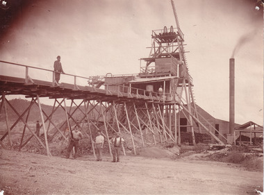
... building, which was used to access the elevator to the shaft. Deep lead mining involved placing large shafts into the ground which miners use to access deeper locations in order to excavate the rocks in the search for lead. Deep lead mining was highly dangerous as roofs could cave in of the soil was loose. Therefore, this particular mining considered to be highly undesirable profession as many miners did not want to work long hours nor risk their lives in the search for lead. Indigo Shire...building, which was used to access the elevator to the shaft. Deep lead mining involved placing large shafts into the ground which miners use to access deeper locations in order to excavate the rocks in the search for lead. Deep lead mining was highly dangerous as roofs could cave in of the soil was loose. Therefore, this particular mining considered to be highly undesirable profession as many miners did not want to work long hours nor risk their lives in the search for lead. Indigo Shire ...This photograph depicts four men standing near a large unidentified building. This building is the entrance to a deep lead mine shaft. There is a bridge entering the building, which was used to access the elevator to the shaft. Deep lead mining involved placing large shafts into the ground which miners use to access deeper locations in order to excavate the rocks in the search for lead. Deep lead mining was highly dangerous as roofs could cave in of the soil was loose. Therefore, this particular mining considered to be highly undesirable profession as many miners did not want to work long hours nor risk their lives in the search for lead. Indigo Shire was a large area where deep lead mining took place, and thus the landscape and environment was largely impacted by these mining businesses. The Indigo Shire grew in population and wealth in the early 1850s when people came into this location in the hopes of finding gold and making a fortune. Ultimately, the accessibility and availability of gold and precious metals decreased once the gold reserves dried up and alongside this, the large population moved away. The Ovens was also heavily impacted environmentally as deep mining resulted in the change in land formation.The search for gold is ingrained into the history of Victoria and therefore, images like this one which portray an open cut sluicing site can reveal important information for society and technology for the date when the photograph was taken. This image is of important historical significance for its ability to convey information about the methods used to find gold in Indigo Shire. It also shows a location where deep mining was undertook which provides insight into the impact of deep mining on the environment at a time when it was done. This image is important for current research into the history of Indigo Shire, a region in Victoria's north-east. Therefore, this image has the capacity to be beneficial for research into society and the motivations of those living and working in this region during this period and therefore, has social significance. The Beechworth Burke Museum has additional images relating to deep lead mining and Indigo Shire which can be analysed and studied alongside images like this one.Sepia coloured retangular photo printed on gloss photographic paper.Reverse: 1997, 2510/ A02570/ Deep Lead Mining/ page 94/ 65%/ Burke Museum, Photo 44beechworth, burke museum, indigo shire, deep lead mining, mining, gold, gold mining -
 Greensborough Historical Society
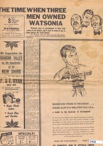
Newspaper Clipping, Diamond Valley News, The Time when three men owned Watsonia; St Katherine's Church at St Helena; When the railway came to the Diamond Valley, 29/09/1964
... Greensborough Historical Society 34A Glenauburn Road Lower Plenty Lower Plenty melbourne Three articles from 1964 on the history of suburbs in the new Shire of Diamond Valley - Greensborough, Watsonia and St Helena. Articles on the building of Greensborough, Montmorency and Watsonia Railway Stations, and establishment of St Helena. greensborough railway station montmorency railway station watsonia watsonia railway station beale family frank watson shire of diamond valley st helena Pp. 28-30 of Diamond Valley News, 29 September 1964. ...Three articles from 1964 on the history of suburbs in the new Shire of Diamond Valley - Greensborough, Watsonia and St Helena.Articles on the building of Greensborough, Montmorency and Watsonia Railway Stations, and establishment of St Helena.Pp. 28-30 of Diamond Valley News, 29 September 1964.greensborough railway station, montmorency railway station, watsonia, watsonia railway station, beale family, frank watson, shire of diamond valley, st helena -
 Greensborough Historical Society
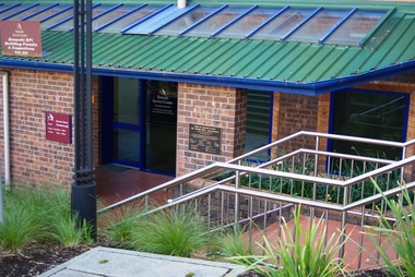
Photograph - Digital Image, Marilyn Smith, City of Banyule Offices Flintoff Street, 01/08/2015
... This building was constructed as offices for the Shire of Diamond Valley (1994) and was formerly the Greensborough service centre of the Banyule City Council, The office is now closed and the building sold. ...Greensborough Historical Society 34A Glenauburn Road Lower Plenty Lower Plenty melbourne This building was constructed as offices for the Shire of Diamond Valley (1994) and was formerly the Greensborough service centre of the Banyule City Council, The office is now closed and the building sold. ...This building was constructed as offices for the Shire of Diamond Valley (1994) and was formerly the Greensborough service centre of the Banyule City Council, The office is now closed and the building sold. New Council offices are under construction (2016) at One Flintoff Street, above Watermarc.Part of the changing landscape of Greensborough.Digital image of colour photograph.banyule city council -
 Greensborough Historical Society
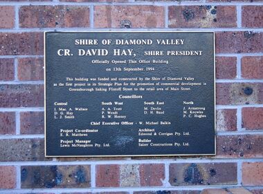
Photograph - Digital Image, Marilyn Smith, City of Banyule Offices Flintoff Street - Shire of Diamond Valley Plaque 1994, 13/09/1994
... This building was constructed as offices for the Shire of Diamond Valley and was formerly the Greensborough service centre of the Banyule City Council, The office is now closed and the building sold. ...This building was constructed as offices for the Shire of Diamond Valley and was formerly the Greensborough service centre of the Banyule City Council, The office is now closed and the building sold. ...Close up of plaque. This building was constructed as offices for the Shire of Diamond Valley and was formerly the Greensborough service centre of the Banyule City Council, The office is now closed and the building sold. New Council offices are under construction (2016) at One Flintoff Street, above Watermarc.Part of the changing landscape of Greensborough.Digital image of colour photograph.banyule city council, shire of diamond valley -
 Greensborough Historical Society
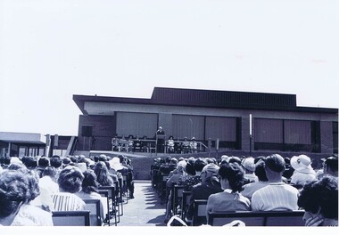
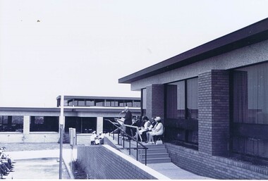
Photograph - Photograph - Digital Image, Opening of Shire of Diamond Valley offices 1972: Exterior view of building and crowd, 26/02/1972
... Opening of Shire of Diamond Valley offices 1972: Exterior view of building and crowd...The official opening of the Shire of Diamond Valley offices in Greensborough on 26/02/1972. These photographs show an exterior view of the new building and the crowd in attendance....Greensborough Historical Society 34A Glenauburn Road Lower Plenty Lower Plenty melbourne The official opening of the Shire of Diamond Valley offices in Greensborough on 26/02/1972. These photographs show an exterior view of the new building and the crowd in attendance. ...The official opening of the Shire of Diamond Valley offices in Greensborough on 26/02/1972. These photographs show an exterior view of the new building and the crowd in attendance.Photographs taken by a member of SDV staff.Photographs from of a folder of 21 colour photographsOn cover of folder "Opening of S.D.V. Office"shire of diamond valley, shire of diamond valley offices 1972 -
 Greensborough Historical Society
Photograph - Photograph - Digital Image, Opening of Shire of Diamond Valley offices 1972: Exterior view of building and seated officials, 26/02/1972
... Opening of Shire of Diamond Valley offices 1972: Exterior view of building and seated officials...The official opening of the Shire of Diamond Valley offices in Greensborough on 26/02/1972. This photograph shows an exterior view of building and seated officials, with Sir Rohan Delacombe addressing the crowd....Greensborough Historical Society 34A Glenauburn Road Lower Plenty Lower Plenty melbourne The official opening of the Shire of Diamond Valley offices in Greensborough on 26/02/1972. This photograph shows an exterior view of building and seated officials, with Sir Rohan Delacombe addressing the crowd. ...The official opening of the Shire of Diamond Valley offices in Greensborough on 26/02/1972. This photograph shows an exterior view of building and seated officials, with Sir Rohan Delacombe addressing the crowd.Photographs taken by a member of SDV staff.Photographs from of a folder of 21 colour photographsOn cover of folder "Opening of S.D.V. Office"shire of diamond valley, shire of diamond valley offices 1972, sir rohan delacombe -
 Greensborough Historical Society
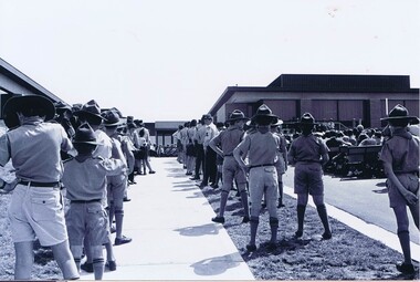
Photograph - Photograph - Digital Image, Opening of Shire of Diamond Valley offices 1972: Scouts at opening ceremony, 26/02/1972
... The official opening of the Shire of Diamond Valley offices in Greensborough on 26/02/1972. This photograph shows an exterior view of building and assembled scouts taking part in the ceremony....Greensborough Historical Society 34A Glenauburn Road Lower Plenty Lower Plenty melbourne The official opening of the Shire of Diamond Valley offices in Greensborough on 26/02/1972. This photograph shows an exterior view of building and assembled scouts taking part in the ceremony. ...The official opening of the Shire of Diamond Valley offices in Greensborough on 26/02/1972. This photograph shows an exterior view of building and assembled scouts taking part in the ceremony.Photographs taken by a member of SDV staff.Photographs from of a folder of 21 colour photographsOn cover of folder "Opening of S.D.V. Office"shire of diamond valley, shire of diamond valley offices 1972, scouts - greensborough -
 Greensborough Historical Society
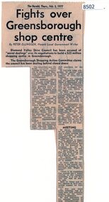
Article - Newspaper Clipping, The Herald, Fights over Greensborough shop centre, 03/02/1977
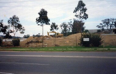
... Shows local resistance to the building of a large shopping complex in Greensborough. greensborough plaza shire of diamond valley Bob Fell News article, black text Fights over Greensborough shop centre Article Newspaper Clipping The Herald Peter Ellingsen ...This article covers some of the issues when the development of Greensborough Plaza was in the planning stages in 1977.Shows local resistance to the building of a large shopping complex in Greensborough.News article, black textgreensborough plaza, shire of diamond valley, bob fell -
 Greensborough Historical Society
Photographs, Building McDonalds Eltham, 1991, 26/05/1991
... 3 photographs of the building of McDonalds Eltham 1991, taken by Peter Graham, a Shire of Eltham Councillor. ...Greensborough Historical Society 34A Glenauburn Road Lower Plenty Lower Plenty melbourne 3 photographs of the building of McDonalds Eltham 1991, taken by Peter Graham, a Shire of Eltham Councillor. ...3 photographs of the building of McDonalds Eltham 1991, taken by Peter Graham, a Shire of Eltham Councillor. There was some opposition to the opening of this food chain in Eltham.3 colour photographs.peter graham, eltham, mcdonalds eltham -
 Greensborough Historical Society
Photograph, Eltham Community Centre April 1979, 17/04/1979
... Shire. It retains the unique character of the original iconic mudbrick building, it was refurbished in 2017....Shire. It retains the unique character of the original iconic mudbrick building, it was refurbished in 2017. peter graham eltham eltham community reception centre 1 colour photograph. ...A photograph of the Eltham Community Centre. The Eltham Community Reception Centre is owned and operated by Nillumbik Shire. It retains the unique character of the original iconic mudbrick building, it was refurbished in 2017.1 colour photograph.peter graham, eltham, eltham community reception centre -
 Greensborough Historical Society
Memorabilia - Reports, Shire of Diamond Valley, Shire of Diamond Valley President's reception for South East Riding ratepayers, 01/05/1974
... Topics included: Rates, Home Help Service, Child care, Pre-schools, Plan future development, Branch Library, Subdivisions, Roads, Buildings, Greensborough Shopping Centre re-development, Re-cycling-incineration, Recreation, Public nuisance - dogs and mini bikes, Multi unit development, Freeways, Shire Office Hours....Topics included: Rates, Home Help Service, Child care, Pre-schools, Plan future development, Branch Library, Subdivisions, Roads, Buildings, Greensborough Shopping Centre re-development, Re-cycling-incineration, Recreation, Public nuisance - dogs and mini bikes, Multi unit development, Freeways, Shire Office Hours. ...Report compiled by the Riding Councillors Faye Wilkes-Johnson, Michael Chick and Bill Toy represent recent and current activities. Topics included: Rates, Home Help Service, Child care, Pre-schools, Plan future development, Branch Library, Subdivisions, Roads, Buildings, Greensborough Shopping Centre re-development, Re-cycling-incineration, Recreation, Public nuisance - dogs and mini bikes, Multi unit development, Freeways, Shire Office Hours.Bruce Morgan was the first Shire Secretary (1964-1983) of the Shire of Diamond Valley. This collection was compiled by his wife, Mavis Morgan, detailing the events they attended in their official capacity2 p. report with black textbruce morgan, mavis morgan, shire of diamond valley -
 Greensborough Historical Society
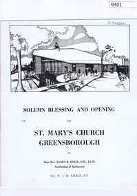
Memorabilia - Program, St Marys Catholic Church Greensborough, Solemn blessing and opening of St Mary's Church Greensborough 1971, 27/10/1971
... building. An insert is the Mass booklet for the 'Blessing of a Church'. Bruce Morgan was the first Shire Secretary (1964-1983) of the Shire of Diamond Valley. ...Information booklet and Mass booklet to celebrate the opening of St Mary's Church Greensborough by Archbishop Knox in 1971. Includes a tribute to Father Thomas Ashe, Mass booklet and short history of St Mary's Parish and Church including a small plan of Church building. An insert is the Mass booklet for the 'Blessing of a Church'.Bruce Morgan was the first Shire Secretary (1964-1983) of the Shire of Diamond Valley. This collection was compiled by his wife, Mavis Morgan, detailing the events they attended in their official capacity8 page brochure printed in black on cream card, includes separate insert blessings pages.bruce morgan, mavis morgan, st mary's greensborough, st mary's catholic church greensborough