Showing 10763 items
matching sites
-
 Bendigo Historical Society Inc.
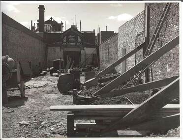
Photograph - BENDIGO ARCADE
black and white photograph: demolition site with brick walls of adjoining buildings with supporting props. Machinery on site. At end of site sign over doorway. J.H.ABBOTT & C0Alan Doneyplace, arcade, bendigo arcade -
 Bendigo Historical Society Inc.
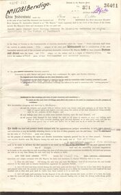
Document - MCCOLL, RANKIN AND STANISTREET COLLECTION: SITE LEASE, 3rd October, 1950
Mining site lease No. 11281. The lease of the site is for Machinery for the South Nell Gwynne Gold Mining Co., includes Map of the site. Dated 2nd September 1950.gold, mining, lease, bendigo, gold mines, mining lease, south nerll gwynne gold mining co. -
 Tatura Irrigation & Wartime Camps Museum
Photograph, Corner Frances and Casey Streets, Tatura
Shows site of old Sacred Heart School, corner of Frances and Casey Streets, Tatura. Shows back of St Mary's and Convent.Colour photograph showing site of old Sacred Heart School, corner of Frances and Casey Streets, Tatura. Shows back of St Mary's and Convent. Photograph stuck onto piece of white cardboard. hogan street tatura, tatura businesses, st mary's school tatura, st mary's convent tatura, frances street tatura, casey street tatura -
 Ringwood and District Historical Society
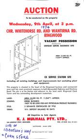
Flyer, Flyer advertising auction sale of ex service station site in Ringwood, Victoria - 1974
Single page advertisement for auction sale of restricted business site, corner of Whitehorse Road and Wantirna Road, Ringwood, Victoria, on Wednesday, 9th April (1974).Advertisement includes location map and terms of sale of 3 separate certificates of title on land zoned as Restricted Business (Not to be used for any petroleum product business). Sole Agents - K.J. Mulhall Pty. Ltd., 358 Lonsdale Street, Melbourne (Telephone) 67 8338, A.H. 91 1511. Auctioneer - Allan Lord. Handwritten notation describes this as originally the site of Ibbotson's Hay and Corn Store. -
 Bendigo Historical Society Inc.
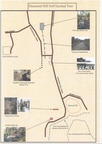
Document - DIAMOND HILL SELF GUIDED TOUR
One page coloured map of historical sites in the Diamond Hill area. Including the Golconda Battery site, Tramway Embankment, site of former Town and Country Hotel, Sandhurst Municipal Boundary Marker Post, Waterwheel Cutting, Stafford Mine site. On the back a description of the various sites. Produced by the Bendigo Historical Societybendigo, tourism, diamond hill -
 Ringwood and District Historical Society
Photograph, 1973 view of the former site of Cass's School (1873-1894) at the corner of Everard Road and Maroondah Highway Ringwood East
Typed below photograph, "Site of Cass's School 1873-1894. Photo taken 1973. Present site of 'Lionsbrae'". -
 City of Moorabbin Historical Society (Operating the Box Cottage Museum)
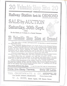
Article - Advertisement for shop sites on North Road at the Ormond Station, 1922
The train line from the city to Frankston was electrified in 1922 which intensified the sale in the municipality of Moorabbin, particularly land which was in the vicinity of the railway stations.Example of the progress of the Municipality of MoorabbinAdvertising flyer for auction of real estate sales - plan of building blocks for saleAdvertisement for shop sites on North Road at the Ormond Station - 20 Shop sites - Auction 30 September 1922north road, ormond, moorabbin -
 City of Moorabbin Historical Society (Operating the Box Cottage Museum)
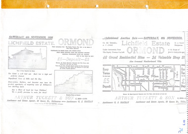
Flyer - Lichfield Estate, Ormond, 1926
The train line from the city to Frankston was electrified in 1922 which intensified the sale in the municipality of Moorabbin, particularly land which was in the vicinity of the railway stations.Example of the progress of the Municipality of MoorabbinPhotocopy of advertising flyer for auction of real estate sales - plan of building blocks for saleLichfield Estate, Ormond Auction Saturday 6 November 1926 - 46 residential sites & 24 shop siteswalnut street, collins street, north road, logan ave, ormond, real estate, auctions -
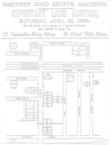 City of Moorabbin Historical Society (Operating the Box Cottage Museum)
Flyer - McKinnon Road Estate, McKinnon, 1924
The train line from the city to Frankston was electrified in 1922 which intensified the sale in the municipality of Moorabbin, particularly land which was in the vicinity of the railway stations.Example of the progress of the Municipality of MoorabbinAdvertising flyer for auction of real estate sales - plan of building blocks for saleMcKinnon Road Estate, McKinnon Auction 26 April 1924 - 17 shop sites & 21 villa sitesgraham ave, prince edward ave, station street, mckinnon road, mckinnon, real estate, auctions -
 Phillip Island and District Historical Society Inc.
Photograph, Late 1800's
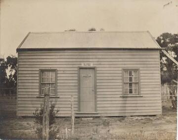
Donated by Jean Parle. The house was firstly named "Speke Villa" then changed to "Hollydene". Black & White photograph of small wooden house with two windows and door in between. Trees each side in background. Owned by Bill Kennon. House in Thompson Avenue, Cowes.On Back: "Speke Villa on site of Hollydene"bill kennon, speke villa, hollydene, cowes phillip island, jean parle -
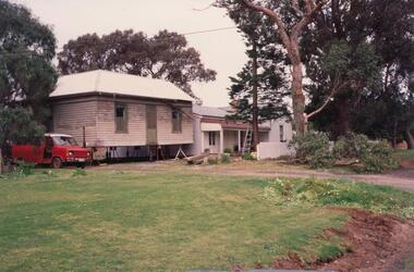 Phillip Island and District Historical Society Inc.
Photograph, Charmandene, 1989
One of 9 photographs donated by Mrs ChampionColour photograph of buildings ready to be linked up - Charmandene now at 29 Osborne Avenue, Cowes.On back: On site ready for the link up"charmandene cottage cowes phillip island, charmandene cottage, cowes phillip island, phillip island, mrs champion -
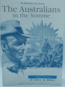 Ringwood RSL Sub-Branch
Book - Australians in the Somme, The Australians in the Somme, June, 2001
Soft cover 22 pages containing history black and white and colour prints.Tour guide 18 sites of memory -
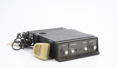 Department of Energy, Environment and Climate Action
Phillips FM 828 Radio
After the 1939 bushfires, the Forests Commission Victoria invested heavily in a radically new communications network. After suffering some inevitable delays due to the war, radio VL3AA switched into full operation in October 1945 proudly beaming out 200 watts across the State. But by today’s standards, the technology was primitive and the reception poor unless the user was on a high point somewhere. The radio signal was "line-of-sight" and bounced between fire towers and relay transmitters across the mountains back to the District offices. The advent of solid-state electronics in the 1960s replaced the more delicate valve sets which enabled greater use of vehicle mounted radios. The Commission continued to research, develop and build new radios at its many workshops around Victoria. The network was supported by a large team of skilled radio technicians. The more secure and versatile State Mobile Radio (SMR) digital trunk system came into operation in about 1995. Upgraded Tait Radios were purchased in 2014 after recommendations of the 2009 Bushfires Royal Commission. But it was the convergence of separate technologies such as 5G mobile phones, high-capacity and light-weight lithium batteries, Wi-Fi, the ever-expanding internet, cloud data storage, digital cameras, GPS, personal organisers and hundreds of supporting Apps into powerful smartphones and tablets which revolutionised bushfire communications from the mid-2000s. Radio with handsetMt Hickey remote radio sitebushfire, radios, forests commission victoria (fcv) -
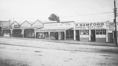 Ringwood and District Historical Society
Photograph, Maroondah Highway Central, Ringwood. P. Bamford store, corner Warrandyte Road. c1924
Black and white photograph (2 copies) Site later to become Safeway store. -
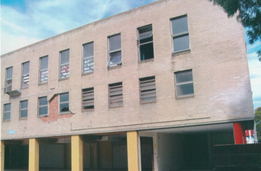
 Port Melbourne Historical & Preservation Society
Photograph - J Kitchen & Sons perimeter survey, north corner Ingles and Woodruff Streets, Dec 2013
As the former j Kitchen & Sons site was being cleared, Lionel Layfield, who had worked at the site for many years undertook several pictorial perimeter surveys. These photos were taken in Dec 2013.Series 1 of colour photographs taken by Lionel Layfield as he walked around the perimeter of the J Kitchen & Sons Pty Ltd factory site during the early demolition of most of the buildings. .46-.54- warehouse on North corner of Ingles and Woodruff streetsindustry - manufacturing, built environment - industrial, business and traders - soaps/candles, j kitchen & sons pty ltd, symex holdings ltd, north port oval, port melbourne cricket and football oval -
 Whitehorse Historical Society Inc.
Pamphlet, Hill 60 Estate, 1/02/1929 12:00:00 AM
Auctioneers brochure for Hill 60 estate,Auctioneers brochure for Hill 60 estate, Tunstall, 37 sites, subdivisional auction sale, 3.30 pm Saturday 23 February 1929. Agent: Frank Fisher & CoAuctioneers brochure for Hill 60 estate, hill 60 estate, tunstall, frank fisher & co, forest hill, menin road, nunawading, mount pleasant road, nunawading, shady grove, nunawading, fisher, frank -
 Lakes Entrance Historical Society
Photograph - Bullock Island, Fish Marie, 1995
Also another black and white photograph of cleared site of Pecks factory 01611.1Black and white photograph of Bullock Island. It shows the site of Pecks fishing processing factory being cleared, Kalimna Heights in background taken from New Works area of southern shore of Cunninghame Arm. Lakes Entrance Victoriaislands, historic site -
University of Melbourne, Burnley Campus Archives
Plan, Base Plan Front Garden Maughan Parade, c. 1980
1. Tracing paper and paper copies, Site Plan. Scale 1:100. Drawn by JK. 2. Site plan Scale 1:200 (plan of whole site)maughan parade, gardens -
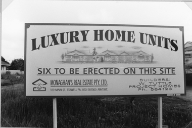 Stawell Historical Society Inc
Photograph, St. Matthew’s Sunday School -- former site c1990
Site of former Sunday school c 1990.Adverting sign from Monaghan's Real Estate with image of the houses.LUXURY HOME UNITS Six to be erected on this site. Monaghen's Real Estate Pty Ltd. 189 Main St. Stawell Ph. 053 581300 anytime. Builders W. Tuttle Project Homes Ph. 584123stawell religion -
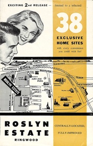 Ringwood and District Historical Society
Flyer, Land Sale Brochure - Roslyn Estate, Ringwood, Vic. - circa 1960s
Land sale advertisement for 2nd release of residential sites with area map, layout of the estate, terms of sale, and summary of local facilities and services.Subdivision includes Daisy Street, Vale Street, Joan Court, Christine Court, and Westmore Drive. (Agent) Heathmont Estate Agency, 103 Canterbury Road, Heathmont. (Phone) WU7808-9. Brochure also includes map with streets marked as "Sold" - Reilly Street, Adrian Court, Daisy Street, Jarma Road, Joel Court, and Ross Court, with comment that "all home sites in the first release have already been sold, and most built on." -
 Port Melbourne Historical & Preservation Society
Photograph - J Kitchen & Sons perimeter survey, Williamstown Road and Normanby Road, Dec 2013
As the former j Kitchen & Sons site was being cleared, Lionel Layfield, who had worked at the site for many years undertook several pictorial perimeter surveys. These photos were taken in Dec 2013.Series 1 of colour photographs taken by Lionel Layfield as he walked around the perimeter of the J Kitchen & Sons Pty Ltd factory site during the early demolition of most of the buildings. .01-.08 - corner of Williamstown Road and Normanby Road to Ingles Streetindustry - manufacturing, built environment - industrial, business and traders - soaps/candles, demolitions, j kitchen & sons pty ltd, symex holdings ltd, north port oval, port melbourne cricket and football oval -
Whitehorse Historical Society Inc.
Document - Drawing, Schwerkolt Cottage site management review, 1/01/1994
Site development opportunities for Schwerkolt Cottage. Drawing prepared for Site Management Review for City of Nunawading.schwerkolt cottage -
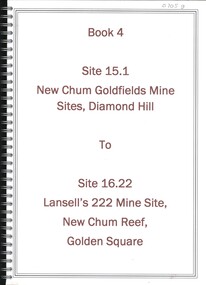 Bendigo Historical Society Inc.
Book - NEW CHUM GOLDFIELDS MINE SITE DIAMOND HILL TO LANSELL'S 222 MINE SITE NEW CHUM REEF GOLDEN SQUARE, 1992
Book 4, Site 15.1 New Chum Goldfields Mine site Diamond Hill to site 16.22, Lansell's 222 Mine site, New Chum Reef, Golden Square. Significance reports prepared for North Central Goldfields Project: Bendigo Goldfield.David Bannearbendigo, mining, goldfields report, bendigo, gold, goldfields, history -
 Port Melbourne Historical & Preservation Society
Photograph - J Kitchen & Sons perimeter survey, Ingles Street, Dec 2013
As the former j Kitchen & Sons site was being cleared, Lionel Layfield, who had worked at the site for many years undertook several pictorial perimeter surveys. These photos were taken in Dec 2013.Series 1 of colour photographs taken by Lionel Layfield as he walked around the perimeter of the J Kitchen & Sons Pty Ltd factory site during the early demolition of most of the buildings. .16-.30- from Munro St along Ingles Street to Woodruff Streetindustry - manufacturing, built environment - industrial, business and traders - soaps/candles, demolitions, j kitchen & sons pty ltd, symex holdings ltd, north port oval, port melbourne cricket and football oval -
 Port Melbourne Historical & Preservation Society
Photograph - J Kitchen & Sons perimeter survey, Boundary Street, Dec 2013
As the former j Kitchen & Sons site was being cleared, Lionel Layfield, who had worked at the site for many years undertook several pictorial perimeter surveys. These photos were taken in Dec 2013.Series 1 of colour photographs taken by Lionel Layfield as he walked around the perimeter of the J Kitchen & Sons Pty Ltd factory site during the early demolition of most of the buildings. .37-.45 - along Boundary Street past White Street to Normanby Roadindustry - manufacturing, built environment - industrial, business and traders - soaps/candles, j kitchen & sons pty ltd, symex holdings ltd, north port oval, port melbourne cricket and football oval -
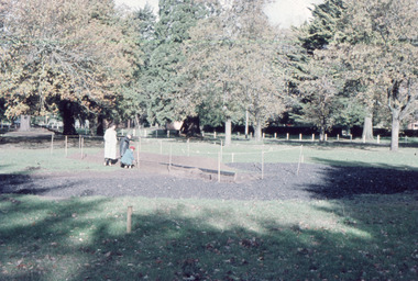 Friends of Ballarat Botanical Gardens History Group
Slide - Colour transparency, 1960
The Rotary Club volunteered to build the paddling pool for children in August 1960.Added social amenity to cater for children after WW2.Site for the paddling poolballarat botanical gardens, trees, parks, lawns, men, frank browm, bill roff, rotary club, paddling pool, volunteers, 1960, swimming -
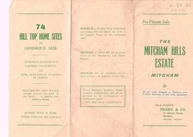 Whitehorse Historical Society Inc.
Document, Mitcham Hills Estate, n.d
Sale brochure for 'Mitcham Hills Estate',Sale brochure for 'Mitcham Hills Estate', 74 sites bordered by McKeon and Quarry Roads, to the order of Commander H.E. Turner and Mrs Turner. Agent: Drake & Co.. With 'List of Sale Prices'.Sale brochure for 'Mitcham Hills Estate',land subdivision, mitcham hills estate, mckeon road, mitcham, quarry road, endeavour street, moresby street, beaufort street, turner, harold exton, cmdr., (mrs), drake & co. -
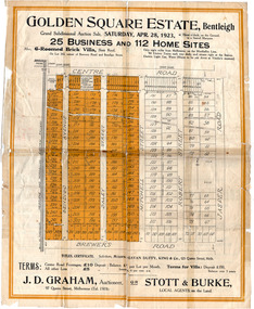 City of Moorabbin Historical Society (Operating the Box Cottage Museum)
Flyer - Golden Square Estate, Bentleigh, 1923
Land sales in the Municipality of Moorabbin increased when the train line from the City to Frankston was electrified.Example of the progress of the Municipality of MoorabbinThe train line from the city to Frankston was electrified which intensified the sale in the municipality of Moorabbin, particularly land which was in the vicinity of the railway stations.Golden Square Estate, Bentleigh - J. D. Graham, Stott & Burke - 25 business sites and 112 home sitescentre road, brewers road, jasper road, robert street, mitchell street, daley street, bendigo avenue, auction, real estate, moorabbin, bentleigh -
Whitehorse Historical Society Inc.
Document, Memorials, 1871 & 1970
Memorial of transfer of land from William Kennard, William Coe & Francis Turner to the Board of Education, 1871 and from L.H.S Thompson, Minister for Education and Board of Education to City of Nunawading 2 June 1970.Memorial of transfer of land from William Kennard, William Coe & Francis Turner to the Board of Education, 1871 and from L.H.S Thompson, Minister for Education and Board of Education to City of Nunawading 2 June 1970. This land became the site of Vermont State School No. 1022.Memorial of transfer of land from William Kennard, William Coe & Francis Turner to the Board of Education, 1871 and from L.H.S Thompson, Minister for Education and Board of Education to City of Nunawading 2 June 1970.victoria, board of education, vermont state school, no, 1022, kennard, william, coe, william, turner, francis, city of nunawading -
 Ballarat Heritage Services
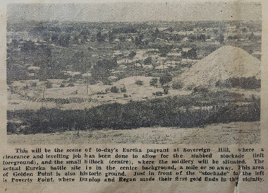
Photograph - Image, Site of the Eureka Pageant, 1954, 1954
The Eureka Pageant was held on Saturday 04 December 1954.A black and white image of Ballarat's Sovereign Hill in 1854. Sovereign Hill was the site of the Eureka Pageant held as part of the Eureka Stockade centenary celebrations.Original caption: This will be the scene of to-day's Eureka pageant at Sovereign Hill, where a clearance and levelling job has been done to allow for the slabbed stokade (left foreground), and the small hillock (centre), where the soldiery will be situated. The actual Eureka battle site is in the centre background, a mile or so away. This area of Golden Point is also historic ground. Just in front of the "Stockade" to the left is Poverty Point, where Dunlop and Egan made their first gold finds in this vicinity.eureka stockade, eureka stockade centenary, sovereign hill, poverty point, eureka pageant, ballarat