Showing 307 items matching "structure of goldfield"
-
 Bendigo Historical Society Inc.
Document - NEW MOON MINE - NOTES ON THE NEW MOON MINE
... /1906 Mines Dept Bulletin 47 'Structure of Bendigo Goldfields' H ...Four typed copies of notes on the New Moon Mine on the Garden Gully Line of Reef. Notes include locality, depth of shaft, last year of production, size of lease, plant, Telephone and electric signalling, early history, gold obtained, prominence, gold production and dividends. Hand drawn locality map included. Albert Richardson Collection.cottage, miners, new moon mine, notes on the new moon mine, h harkness & coy, thompson & co, telephone & electric signalling, 'robin hood' ground, bendigo amalgamated goldfields co, special edition australian mining standard 1/6/1899, mines dept booklet 'bendigo goldfields' 1936, mines dept annual and quarterly reports, annals of bendigo mining section 1907 = 1931, a richardson, souvenir 'declaration of 200th dividend' issued by directors of new moon co 1/12/1906, mines dept bulletin 47 'structure of bendigo goldfields' h herman 1923 -
 Stawell Historical Society Inc
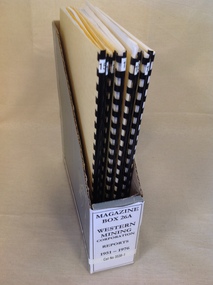
Book, Western Mining Corporation, Western Mining Corporation Reports 1951-1976, 1951-1976
10 Yellow Card and Black Plastic Spine With W.M.C Logo13: Western Mining Corporation Limited G Report No. 34 & 35 14 Western Mining Corporation Limited. The Relationship of Structure and Ore Deposition at Stawell Goldfield, Victoria. 15: Western Mining Corporation Limited. Enviroment Suitable Mining Development Proposal Stawell, Victoria 16: Western Mining Corporation Limited.. K report No 1832 Victorian Drilling Problems 1950 -1965 17: Western Mining Corporation Limited. Exploration for Structural Repetitions at Stawell Victoria A Case History By R.J.S. Clappison 1974 18: Western Mining Corporation Limited. K Report No. 1830 Stawell Prospecting 1958-1965 19: Western Mining Corporation Limited.. Stawell Feasibility Study By K.E. Higgs, J.H. Lalor, J.A. Heycroft & Stawell Start up Gold Price R.A. Nichols. 20: Western Mining Corporation Limited. Proposed Percussion Drilling at Stawell 1975 By D.R. Quick. K Report No 2211 1974-1976stawell gold mining -
 Stawell Historical Society Inc
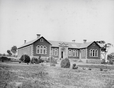
Photograph, Pleasant Creek Hospital 1866
Pleasant Creek Hospital. Part of a collection of Photographs by Mr. O.G. Armstrong as commissioned by the Shire of Stawell for the Inter-colonial and Paris Exhibition in Melbourne in 1866. Due to a public outcry for medical services on the goldfield a public meeting was held in the Olympic Theatre at Deep Lead on the 7th of August 1858. It appointed a 50 man committee to establish a hospital at Pleasant Creek. A temporary Tent structure was soon erected at Doctors Hill, situated midway between Deep Lead and Commercial Street Pleasant Creek, just South of the later Western Highway. The site is now marked by a commemorative stone. Within two months the committee had collected £600 in subscriptions, a government Grant for £2500 and acquired 10 acres of land. The foundation stone of the hospital building was laid on 21st December 1860 and the building completed and occupied by 21st June 1861. In the 1930’s the hospital moved to the centre of Stawell in Sloane Street and the buildings then taken over by the Pleasant Creek Training Centre. Brick hospital building with two ward wings and central front door. Man standing on steps.stawell health -
 Bendigo Historical Society Inc.
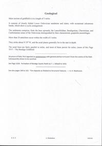
Document - MINING REPORTS - GEOLOGICAL REPORT OF MAIN SECTION OF GOLDFIELD
Handwritten notes by Albert Richardson, with typed copy, on a Geological report of main section in a length of 5 miles. Report mentions sandstones and slates, with occasional calcareous bands, which show a cyclic arrangement. Also mentioned are different zones of sediments, anticlines, structure of the field and references: Page 1028 Formation of Bendigo Quartz Reefs by F R Stilwell to 1032 and pages 160 to 163 'Ore deposits as Related to Structural Features - A H Newhouse. document, gold, mining reports, mining reports, geological report of main section of goldfield, the bendigo goldfields page 1015, formation of bendigo quartz reefs by f r stilwell page 1028 to 1032, ore deposits as related to structural features pages 160 to 163 a h newhouse -
 Ballarat Heritage Services
Photograph - Photograph - Colour, Flag of St Alipius', Ballarat East, 2004, 23/09/2004
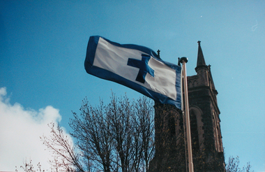
"Centenary of Fnrst Mass at Ballarat Friday last marked the centenary of the arrival of the first priest and the celebration of the first Mass in Ballarat. The Rev. Patrick Dunne reached the diggings on October 17, and on Sunday, October 19, 1851, in a bark hut near Brown Hill, he celebrated Mass. Worshippers had to kneel on quartz gravel. The weather had been the worst experienced in Victoria for a number of years, and most of the creeks between Melbourne and Ballarat were flowing torrents, but Father Dunne (who came from the Coburg mission), carrying the barest necessities and the sacred vestments, set out for Ballarat on horseback. He had to ford and swim his horse across the creeks. When most of his congregation left for the Castlemaine diggings Father Dunne returned to Melbourne. In August, 1852, Rev. Matthew Downing became Ballarat's first resident priest. He built a large wooden structure with a canvas roof which served as a church, but later erected at the Gravel Pits the first permanent church. This church was the largest of any house of worship on any goldfield in the colony. It cost £ 100, contributed solely by Father Downing and his flock. Soon after he got the authorities to survey a large piece of land at the back of the township as a burial ground and procured a grant of £500 for fencing it. A grant of £250 was also obtained for the improvement of the chapel and fittings of a school, where Michael Campion Carey opened the first school. Rev. Patrick Smyth succeeded Father Downing, who was followed by Rev. P. Madden, who in 1857 began to plan the erection of St. Patrick's Church. The foundation stone of this was laid by Bishop Goold on February 12, 1858, and the church was opened for the first time on November 8, 1863." (Melbourne Advocate 25 October 1951)Two colour photographs showing the St Alipius' Catholic Church flag - a blue cross and border on white. st alipius, church, ballarat east, flag -
 Bendigo Historical Society Inc.
Slide - DIGGERS & MINING. THE GOLD ERA, c1855
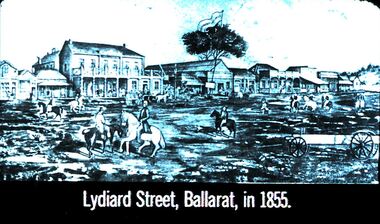
BHS CollectionDiggers & mining. The gold era. Lydiard Street, Ballarat, in 1855. Buildings appear to be wooden structures. The road is not formed but is busy with a couple of wagons, most of the users are men on horseback, one man in the foreground appears to be wealthy as his clothes are upper class. The person on the left on a black horse appears to be a woman. Markings 50 994.031 GOL:5. Used as a teaching aid.hanimounteducation, tertiary, goldfields -
 Bendigo Historical Society Inc.
Document - LONG GULLY HISTORY GROUP COLLECTION: SOME HISTORICAL INFORMATION
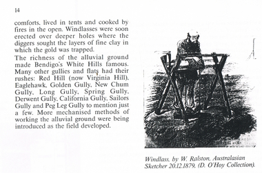
BHS Collection12 photocopied pages. Page four has acknowledgements, Page five mentions Pen-Portraist by Raly Wallace and Kevin Vallence, Page 14 mentions some rich areas: White Hills, Red Hill (now Virginia Hill), Eaglehawk, Golden Gully, New Chum Gully, Long Gully, Spring Gully, Derwent Gully, California Gully, Sailors Gully and Peg Leg Gully. There are two sketches on the page: Windless, by W. Ralston, Australasian Sketcher 20/12/1879 (D O'Hoy Collection) and a sketch of some miners in a tent with some mining equipment in front of it. There are two men in front of a fire at the front of the tent. Page 16 has a sketch of an old brick house with iron lace on the veranda and a picket fence at the front. Page 17 mentions the school and some Friendly Societies and Church. Page 22 mentions Quartz Mining. There is a Lithograph of a Quartz outcrop, New Chum Gully 1852 by George Rowe and a View of Surface Workings 1861, a Batchelder Photo. Page 23 mentions Edward Nucella Emmett, a pioneer gold digger who became involved in many important public issues. Page 25 mentions Company Mining and Crushing. It has a sketch of a Primitive Quart Crusher. Page 37 Mentions Richard Pope, a Miner who tramped from job to job in Bendigo and eventually followed the rush to Broken Hill. Page 38 mentions the Eaglehawk Brass Band and Friendly Societies in Eaglehawk. Page 39 is headed Miner's Cottage. It mentions stone miners' cottages. Page 40 has a sketch of a Georgian Style Sandstone Cottage Harvey Town. Page 41 mentions men sweeping the road to get gold, Bull Family grocery shop and a blacksmith. Page 42 is headed St. Augustine's. Page 43 has a sketch of St. Augustine's Church. Page 59 is headed Bendigo Amalgamated Goldfields (B.A.G.) Edward Clarence Dyason was largely behind a new company set up in 1917 to work the Bendigo field in an entirely new way. (B.A.G.) wished to take over all existing mining companies, and place them under a single management structure.bendigo, history, long gully history group, the long gully history group - some historical information, mr l hooley, mr l bennetts, mr w watson, mr w heraud, mr d m davies, mr w perry, mr h harvey, mr a llewellyn, mr e oates, chook temple by mr alan llewellyn, mr f cusack, tracey ipsen, ray wallace, bendigo field naturalists' club, eaglehawk tree lovers' society, bendigo historical society, university of melbourne, kevin vallence, monash university, bendigo technical college, south australian writer's fellowship, windlass, w ralston, australasian sketcher 20.12.1879, d o'hoy, mechanics institute, california gully school, bell topper hill, i.o.r. (rechabites), cobden tent, refuge tent, sutton tent, m.u.i.o.o.f.'s loyal darling, bible christian church, california hill wesleyan methodist church, saint jude's anglican church, quartz mining, e n emmett, jonathan harris, haris' claim, j hustler, george rowe, batchelder, la trobe library, cave, amos, new chum line of reef, edward nucella emmett, bendigo city council, all saints, william westgarth, latham and watson, hustler's line of reef, bell and irons, ballerstedt and son, young and company, nicholas and bassit, ensor, thomas carpenter, quartz crusher, goldfields and mineral districts of victoria, richard pope, daniel webster mine, isaac dyason, old chum mine, north old chum mine, young chum mine, george lansell, lazarus, silicosis of the lungs, eaglehawk brass band, victoria hotel, mr williams, eaglehawk branch of the australian natives association, loyal catherine lodge, mr james, odd fellows in the loyal catherine lodge branch no 4935, richard harvey, thomas harvey, moonta copper mines, harvey town, national trust of australia, eaglehawk tree lovers society, saint mungo's methodist church, clark's beehive battery, world war 1, kee-young, lady barkly hotel, prankhurst, bull family, cousin jack, st augustine's, myers, nicholls, john o'brien, around the boree log, the rev dean hayes, st kilian's, bendigo amalgamated goldfields (b.a.g.), edward clarence dyason, r h s abbott, hercules and energetic, south new moon, new chum goldfields, central red white and blue consolidated, brown john, the life and times of long gully, bendigo press, val white, megan snoop