Showing 4052 items matching "surveying"
-
 Glenelg Shire Council Cultural Collection
Photograph - Photograph - Aerial Photo railway line between Heywood and Rennick, 03/05/1952
Victorian Railways aerial survey record print of the railway line between Heywood and Rennick (S.A. border) Black and white, white vertical strip on imageFront: Annotations in black pencil added at a later date Back: 'Heywood - Rennick 21149 - 19430 240m 79c Heywood' - all black ink. Purple VR aerial survey stamp. '3 May 1952' - black stamp -
Glenelg Shire Council Cultural Collection
Photograph - Photograph - Aerial Photo railway line between Heywood and Rennick, 03/05/1952
Victorian Railways aerial survey record print of the railway line between Heywood and Rennick (S.A. border) Black and white, white vertical strip on imageFront: Annotations in black texta added at a later date Back: 'Heywood - Rennick 21358 - 19629 258m 23c Heywood' - all black ink. Purple VR aerial survey stamp. '3 May 1952' - black stamp -
Glenelg Shire Council Cultural Collection
Photograph - Photograph - aerial view of railway line, 03/05/1952
Victorian Railways aerial survey record print of the railway line between Heywood and Rennick (S.A. border) Black and white, white vertical strip on imageFront: Notations in black pen, added at a later date Back: 'Heywood - Rennick 21082 - 19373 235m 73c Heywood' - all black ink. Purple VR aerial survey stamp. '3 May 1952' - black stampvictorian railways, aerial photography, train line -
Glenelg Shire Council Cultural Collection
Photograph - Photograph - Aerial Photo railway line between Heywood and Rennick, 03/05/1952
Victorian Railways aerial survey record print of the railway line between Heywood and Rennick (S.A. border) Black and white, white vertical strip on imageFront: 'to Rennick, Heywood from Melbourn' in the whites strip Back: 'Heywood - Rennick 21077 - 19368 235m 67c Heywood' - all black ink. Purple VR aerial survey stamp. '3 May 1952' - black stamp -
Glenelg Shire Council Cultural Collection
Photograph - Aerial Survey Railway Record Print – 1952, 03/05/1952
Victorian Railways aerial survey record print of the railway line between Heywood and Rennick (S.A. border) Black and white, white vertical strip on image.Front: Annotations in black ink added at a later date Back: 'Heywood - Rennick 21151 - 19432 241m 14c Heywood' - all black ink. Purple VR aerial survey stamp. '3 May 1952' - black stamp -
Whitehorse Historical Society Inc.
Article, Janette is waste wise, 18/09/1991 12:00:00 AM
Article from Nunawading Post on a 10 year old Janette Lewis from Forest Hill.Article from Nunawading Post on a 10 year old Janette Lewis from Forest Hill winning first place in a state-wide science competition for her survey on domestic garbage and waste minimisation.Article from Nunawading Post on a 10 year old Janette Lewis from Forest Hill. lewis, janette, garbage collection -
 Bendigo Military Museum
Photograph - Army Survey Regiment – Regimental Training, c1960s
These photographs of RASvy personnel from the Army Survey Regiment undertaking regimental training lack any annotation that could identify names, dates and locations. The training was possibly conducted at Balcombe and Dromana, located on the Mornington Peninsula, Victoria. There is no explanation on the meaning of the annotation on back of the last photograph.This is a set of photographs of Army Survey Regiment personnel undertaking regimental training in the 1960s. All eight photographs were printed on photographic paper and are part of the Army Survey Regiment’s Collection. The photographs were scanned at 300 dpi. .1) to .7) Photo, black & white, Regimental Training .8) Photo, black & white, possibly Regimental Training.1) to .7) annotated on back “Regimental Training” .8) annotated on back “Fatted Pig-Coal Lift-Western Mines”royal australian survey corps, rasvy, army survey regiment, army svy regt, fortuna, asr -
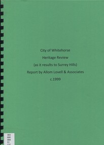 Surrey Hills Historical Society Collection
Book, City of Whitehorse Heritage Review (as it relates to Surrey Hills), 1999
A street by street survey of each of the proposed precincts was undertaken. For each precinct, building fabric was defined in terms of intactness, scale, construction type, architect and predominant eras of construction.A street by street survey of each of the proposed precincts was undertaken. For each precinct, building fabric was defined in terms of intactness, scale, construction type, architect and predominant eras of construction.cultural property, protection of historic sites, heritage overlay precincts, heritage review, building citations -
Whitehorse Historical Society Inc.
Article, LGB praise for Council, 1994
Leonie Burke, Local Government Board Chairperson was impressed by Nunawading's preparation and community inclusion in the impending amalgamation decision.Leonie Burke, Local Government Board Chairperson was impressed by Nunawading's preparation and community inclusion in the impending amalgamation decision. Cr Abbott stated Box Hill's resident survey was incorrect regarding rates after a merger.Leonie Burke, Local Government Board Chairperson was impressed by Nunawading's preparation and community inclusion in the impending amalgamation decision. local government, city of box hill, city of nunawading, city of whitehorse, amalgamations, local government finance -
Glenelg Shire Council Cultural Collection
Photograph - Aerial Survey Railway Record Print – 1952, 03/05/1952
Victorian Railways aerial survey record print of the railway line between Heywood and Rennick (S.A. border) Black and white, white vertical strip on imageFront: Annotations in red and black ink made at a later date Back: 'Heywood - Rennick 21085 - 19376 236m 9c Heywood' - all black ink. Purple VR aerial survey stamp. '3 May 1952' - black stamp -
Glenelg Shire Council Cultural Collection
Photograph - Photograph - Aerial Photo railway line between Heywood and Rennick, 03/05/1952
Victorian Railways aerial survey record print of the railway line between Heywood and Rennick (S.A. border) Black and white, white vertical strip on imageFront: annotations in red and black ink, made at a later date Back: 'Heywood - Rennick 21084 - 19375 235m 31c Heywood' - all black ink. Purple VR aerial survey stamp. '3 May 1952' - black stamp -
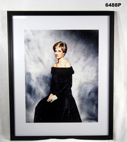 Bendigo Military Museum
Photograph - HRH The Princess of Wales "Lady Diana" - Colonel in Chief of the Royal Australian Survey Corps, 1988
Her Majesty, Queen Elizabeth II approved the appointment of HRH The Princess of Wales "Lady Diana" as the Colonel in Chief of the Royal Australian Survey Corps (RASvy) on 1 July 1988. A copy of this image was presented to RASvy for official use.Framed photograph of HRH The Princess of Wales "Lady Diana" - Colonel in Chief of the Royal Australian Survey Corps in a black dress, white border and black frame.royal australian survey corps, rasvy, fortuna, army survey regiment, army svy regt, asr -
 Bendigo Military Museum
Photograph - AITA Award - RA Svy’s AUTOMAP 2 Computer Based Map Production System, Army Survey Regiment, Fortuna, Bendigo, 1984
This collection of three photos of the Australian information Technology Award (AITA) won by the Royal Australian Survey Corps (RA Svy) AUTOMAP 2 computer-based map production system, was taken in 1984 at the Army Survey Regiment, Fortuna, Bendigo. The following article appeared in the ARMY Newspaper on Thursday 21st February 1985. ‘In computerised map production. Survey soldiers lead the world. BENDIGO: Army surveyors have been put on the map as world leaders in computerised map production following the Australian information Technology Awards. RA Svy won the Computer Assisted Draughting – Mapping section for its Automap II System which has created considerable interest among overseas defence experts. The award for the digital mapping system was accepted by OC Air Survey Sqn, MAJ Rob John, who said it was a great morale-booster for the soldiers of the Bonegilla (sic)* -based Army Survey Regiment. "Setting up a state-of-the-art system like Automap II. is an enormous task, " he said. "We started in August 1983 and it's only recently that we have achieved production results. "We were all very pleased to have our efforts recognised in this way. “Of course, credit must also go to the Intergraph Corporation for manufacturing the system and carrying out most of the development." RA Svy is responsible for producing all of Australia's maps used for defence purposes. Its topographical maps have a scale of 1:50,000 or 1:100,000 although Automap II has the capability of producing smaller scale maps - down to 1: 2,000,000. Automap II consists of three computers and three sub-systems: input, raster scanning, and graphic edit. The input sub-system has eight stereo plotters, two interactive graphic workstations and a system manager workstation. The stereo plotters use superimposition optics to digitise features from aerial photographs. It incorporates a voice recognition system so the operator can simply say "House", "Windmill", etc; and the relevant feature will be incorporated in the digital picture. Individual map separations are scanned and converted by the raster scanning sub-system to a digital raster image. This image is then converted to a graphics file in Intergraph format.’ *Note – the Army Survey Regiment was located in Bendigo, not Bonegilla as incorrectly stated in the article. The article appears on Page 137 of Valerie Lovejoy’s book 'Mapmakers of Fortuna – A history of the Army Survey Regiment’ ISBN: 0-646-42120-4. Additional history of the AUTOMAP 2 system with historic photographs is covered in pages 119, 137-143 and 157 of the 'Mapmakers of Fortuna’ book. See item 6223.23P for additional history and photographs of the AUTOMAP 2 system.This collection of three photos of the Australian information Technology Award (AITA) won by the Royal Australian Survey Corps (RA Svy)’s AUTOMAP 2 computer-based map production system, was taken in 1984 at the Army Survey Regiment, Fortuna, Bendigo. The photographs are printed on photographic paper and are part of the Army Survey Regiment’s Collection. The black and white photographs were scanned at 300 dpi. .1) - Photo, black & white, 1984, AITA Award sitting between the dual screens of an AUTOMAP 2 Graphic Edit Workstation. .2) - Photo, black & white, 1984, MAJ Job Johns (centre) and two of Intergraph Corporation IT engineers proudly hold the AITA Award next to an AUTOMAP 2 Graphic Edit Workstation. .3) - Photo, black & white, 1984, The AITA Award displayed on a pedestal in the Army Survey Regiment Officers Mess. .1P to .3P –No personnel are identified. ‘AITI Award to AUTOMAP II 1984’ annotated on cover sleeve. royal australian survey corps, rasvy, army survey regiment, army svy regt, fortuna -
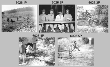
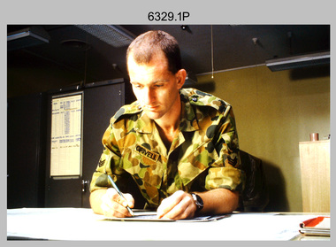 Bendigo Military Museum
Photograph - Tasks Demonstrated by Royal Australian Survey Corps Technicians, c1990s
This is a set of 17 photographs of technicians from the Royal Australian Survey Corps undertaking technical tasks circa 1990s. Photos .1P to .9P were taken at the Army Survey Regiment, Fortuna, Bendigo. Photos .10P to .15P and .17P of students operating survey equipment, were taken at the School of Military Survey, Bonegilla and survey stations surrounding Lake Hume. The base camp at photo .16P was probably taken at Sandy Creek, near Tallangatta Victoria, during the field phase of a basic or advanced RA Svy training course. CPL Steve Nokes appearing in photo .17P was attending the 1/90 Map Control Survey Course.This is a set of 17 photographs of technicians from the Royal Australian Survey Corps undertaking technical tasks at the Army Survey Regiment, Fortuna, Bendigo, and the School of Military Survey, Bonegilla c1992. Colour photos are on 35mm slide film and were scanned at 96 dpi. Photo .17P is in black & white, printed on photographic paper and scanned at 300 dpi. The photos are part of the Army Survey Regiment’s Collection. .1) – Photo, colour, c1992, Aerial photography Assessment, SGT Tony Grivell. .2) – Photo, colour, c1992, Aerial photography Assessment, L to R: WO2 Noel McNamara and LCPL Grant Lloyd. .3) – Photo, colour, c1992, Wild PUG4 point transfer device, LCPL Mark Fedden. .4) – Photo, colour, c1992, AUTOMAP 2 Graphic Edit Workstation, unidentified technician. .5) – Photo, colour, c1992, Heidelberg Speedmaster 102 computer-controlled five colour lithographic offset printing press, CPL Nick Vanderzwan. .6) – Photo, colour, c1992, Daylight film contact frame, SPR Ken Labourchardiere. .7) – Photo, colour, c1992, Heidelberg Speedmaster 102 Map Colour Evaluation Workstation, SGT Stuart Ridge. .8) – Photo, colour, c1992, Map proof evaluation, CPL John Bragg. .9) – Photo, colour, c1992, Wohlenberg MCS-2 guillotine, unidentified technician. .10) – Photo, colour, c1992, Wild T2 Theodolite, L to R: SPR Matt Arnold, SPR Kim Baker. .11) – Photo, colour, c1992, Wild T2 Theodolite, L to R: SSGT Bob Bright, SPR Kim Baker. .12) to .14) – Photo, colour, c1992, MRA-7 Tellurometer, CPL Mark Bourne. .15) – Photo, colour, c1992, Plane Tabling, CPL Mark Bourne. .16) – Photo, colour, c1992, School of Military Survey base camp, Sandy Creek, VIC. .17) – Photo, black & white, 1990, MRA-7 Tellurometer, CPL Steve Nokes. .1P to .16P - There are no annotations. .17P – annotated on back ‘CPL NOKES WITH MRA7 ON 1/90 MAP CONTROL COURSE’royal australian survey corps, rasvy, army survey regiment, army svy regt, school of military survey, fortuna, asr -
Glenelg Shire Council Cultural Collection
Photograph - Photograph - Aerial Photo railway line between Heywood and Rennick, 03/05/1952
Victorian Railways aerial survey record print of the railway line between Heywood and Rennick (S.A. border) Black and white, white vertical strip on imageFront: Annotations in red ink and black texta, added at a later date Back: 'Heywood - Rennick 21530 - 19793 274m 9c Puralka ' - all black ink. Purple VR aerial survey stamp. '3 May 1952' - black stamp -
 St Kilda Historical Society
Photograph - Photo map, 13/01/1968
One of a series of photo-maps produced for the Department of Crown Lands and Survey (1857-1983). For correlation with a current map, and access to other historical photo maps of Victoria, see the Historic Photo-Maps Index published by the Department of Environment, Land, Water and Planning at https://services.land.vic.gov.au/DELWPmaps/historical-photomaps/Black and white aerial photograph2138 State Aerial Survey Melbourne 1968 Proj. Run 26 13.1.68 5100 ASL 203st kilda west, albert park, fawkner park, south yarra, prahran, windsor, 1968 -
 St Kilda Historical Society
Photograph - Photo map, 11/01/1968
One of a series of photo-maps produced for the Department of Crown Lands and Survey (1857-1983). For correlation with a current map, and access to other historical photo maps of Victoria, see the Historic Photo-Maps Index published by the Department of Environment, Land, Water and Planning at https://services.land.vic.gov.au/DELWPmaps/historical-photomaps/Black and white aerial photographVic 2132 State Aerial Survey Melbourne 1968 Proj. Run 27E 11.1.68 5100 ASLst kilda, st kilda west, st kilda pier, catani gardens, st kilda beach, albert park, 1968 -
Whitehorse Historical Society Inc.
Document, Blackburn Market Survey in Melbourne 1965, 1965
Proposal for market on corner of Williams Road and Springfield Road Blackburn.Proposal for market on corner of Williams Road and Springfield Road Blackburn, carried out by Survey Research Centre for Lend Lease Development Pty Ltd, accompanied by letter from donor of papers, Kathleen OswinProposal for market on corner of Williams Road and Springfield Road Blackburn.blackburn north progress association, lend lease development pty ltd, markets, springfield road, blackburn, williams road, blackburn, oswin, kathleen, blackburn -
Glenelg Shire Council Cultural Collection
Photograph - Photograph - Aerial Photo railway line between Heywood and Rennick, 03/05/1952
Victorian Railways aerial survey record print of the railway line between Heywood and Rennick (S.A. border) Black and white, white vertical strip on imageFront: Annotations in red biro added at a later date Back: 'Heywood - Rennick 21356 - 19627 258m 6c ' - all black ink. White sticker, black print 'Winnap' Purple VR aerial survey stamp. '3 May 1952' - black stamp -
Glenelg Shire Council Cultural Collection
Photograph - Photograph - Aerial Photo railway line between Heywood and Rennick, 03/05/1952
Victorian Railways aerial survey record print of the railway line between Heywood and Rennick (S.A. border) Black and white, white vertical strip on imageFront: Annotations in red ink added at a later date Back: 'Heywood - Rennick 21391 - 19662 261m 18c ' - all black ink. White sticker, black print 'Dartmoor' Purple VR aerial survey stamp. '3 May 1952' - black stamp -
Glenelg Shire Council Cultural Collection
Photograph - Photograph - Aerial Photo railway line between Heywood and Rennick, 03/05/1952
Victorian Railways aerial survey record print of the railway line between Heywood and Rennick (S.A. border) Black and white, white vertical strip on imageFront: Annotations in red biro added at a later date Back: 'Heywood - Rennick 21297 - 19564 254m 2c Heywood' - all black ink. White sticker with 'GREENWALD' printed on it. Purple VR aerial survey stamp. '3 May 1952' - black stamp -
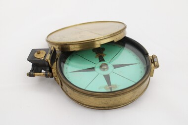 National Communication Museum
Equipment - Prismatic compass, Alfred E Sawtell, before 1872
... surveying ...After years of precursory surveying, debate and proposals the most ambitious civil engineering project of the day, the Overland Telegraph Line, began construction in September 1870. Superintendent of Telegraphs, Sir Charles Todd led the construction through “terra incognita,” guided by the precursory surveys of John McDowall Stuart and technologies such as his prismatic surveying compass. The unknown and hostile landscape claimed the lives of several men and scores of transport animals in the dogged pursuit of telegraphic connection to the rest of the world. Completed in August 1872, the Line connected Australia to the world via telegraph wires running 3,200 kilometres from Port Augusta in South Australia, to Darwin, then connecting via submarine cable to Java and beyond. The “earth [had been] girdled with a magic chain” according to the then Governor of New South Wales, Sir Hercules Robinson. How does it work? For use in surveying, the sight vane and prism are turned up on their hinge and the instrument is held horizontally either in the palm of one's hand or on a tripod. Two small discs of red and green glass attached to the prism can be flipped down over the sight line to reduce glare. The objective is to bring the subject into the sightline created by the prism, aligning with the thread of the sight-vane until the subject is bisected evenly. Once aligned, the division on the card may be read through the prism. This reading provides the magnetic azimuth, used for calculating the bearings of distant landmarks. Circular instrument mounted in a brass case with glass window and brass lid. The compass card face four black compass points printed on mint green paper; on the underside the magnetic needle would be affixed, all held in place by a brass knob at the centre. The arched labels of "Sawtell" and "Adelaide" and the Prince of Wales feathers appear to have been affixed with adhesive which has since yellowed in the areas of application on the compass card. The compass face is printed with numbers, every 10 degrees from 10 - 360, printed in reverse indicating this compass would have once held a mirror at the sighting bracket. On one side of the brass case is a brass hinged sighting-prism, possibly of ebonite. The sighting-prism is mounted in a hinged brass bracket on one edge of the brass case. It has two flip-type filter glasses (red and green) and folds down into a retracted travelling position. A hinged brass bracket on the opposite edge would have held the sighting bracket - carrying the sighting vane and mirror - which is now missing or removed. Under the hinge is a lever, possibly related to the movement of the bracket. Underneath the brass case is an indented circle with screw threads, possibly for attachment to a tripod, and indistinguishable marks scratched into the surface.Etched on to the centre of the lid, "Sawtell ADELAIDE / No 792." Affixed to the paper compass face, possibly from separate pieces of paper, "SAWTELL / ADELAIDE" with the Prince of Wales Feathers above "SAWTELL". Underneath on remains of white tape in red: "159."surveying, compass, charles todd, overland telegraph line, telegraph -
 Bendigo Military Museum
Photograph - Army Survey Regiment - Defence Force Service Medal Presentations, c1977
These photographs were taken at a formal medal presentation at the Army Survey Regiment in 1977. The Director of the Survey Corps presented the Defence Force Service Medal to personnel in recognition of 15 years of efficient remunerated service, or the Clasp for 5 years of additional service.These four colour photographs were taken at a Defence Force Service Medal Presentation in c1977 at the Army Survey Regiment, Bendigo. The photographs were printed on photographic paper and are part of the Army Survey Regiment’s Collection. The photographs were scanned at 300 dpi. .1) Photo, colour, unidentified personnel .2) Photo, colour, unidentified personnel .3) Photo, colour, L to R: WO1 Roger Rix, WO1 Alex Munro, COL Jim Stedman, MAJ Peter Eddy .4) Photo, colour, L to R: WO1 Roger Rix, WO1 Alex Munro, MAJ Peter Eddy, COL Jim Stedman.1 to. 4P - no annotationsroyal australian survey corps, rasvy, army survey regiment, asr, fortuna -
 Bendigo Historical Society Inc.
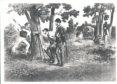
Photograph - WES HARRY COLLECTION: SURVEY PARTY, 1854
... Surveying ...Photograph of a drawing depicting a survey party in 1854. In the left foreground there are Two men, one is looking through a theodolite and another is blazing a mark on to a tree with an axe. Two other men are dragging a chain measure. In the background there is a boy standing by a horse and cart. The whole group is in a bush land setting.organization, lands and survey, original survey, surveying, theodilite, chain -
 Bendigo Military Museum
Photograph - Air Survey Squadron - Army Survey Regiment, Bendigo, c1988
This is a photograph of Air Survey Squadron, one of the Army Survey Regiment’s four squadrons, taken at Fortuna, Bendigo, c1988. Air Survey Squadron’s main functions were aerotriangulation and digital photogrammetric extraction of 3D topographic features from aerial photography, using Wild B8s coupled to the AUTOMAP 2 computer system.This is a photograph of Air Survey Squadron at the Army Survey Regiment, Fortuna, Bendigo, c1988. The photograph was printed on photographic paper and is part of the Army Survey Regiment’s Collection. The photograph was scanned at 300 dpi. .1) - Photo, black & white, c1988: Back Row L to R: SPR Mark Linwood, SPR Trevor Roddam, SPR Noel Brinsmead, CPL Mark Lander, CPL Frank Downie, SPR Sandy Craig 3th Row L to R: SPR Steve Rundle, unidentified, Darren Wilkinson, CPL Dave Longbottom, SPR Max Watson, unidentified, SGT Paul Hopes, unidentified. 2nd Row L to R: SGT John ‘Shep’ Shepherd, SPR Paul Boulton, SPR Stuart Bowd, SPR Paula (Golding) Brinsmead, SPR Jo Otto, CPL Steve Coulson, SPR Steve Linane, CPL Chris ‘Charlie’ Brown. Front Row L to R: SSGT Bruce ‘Hap’ Hammond, WO2 Barry Lutwyche, LT Struan Robinson, SSM WO1 Alan Hancox, OC MAJ Peter Clark, LT Simon Buckpitt, WO2 Neil ‘Ned’ Kelly, SSGT Noel ‘Macca’ McNamara.No personnel are identifiedroyal australian survey corps, rasvy, army survey regiment, army svy regt, fortuna, asr, air survey -
 Bendigo Military Museum
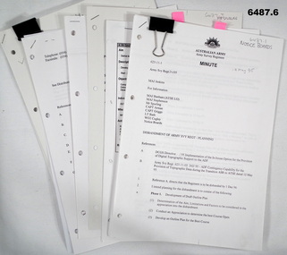
Document - Disbandment of Army Survey Regiment Planning 1995, Army Survey Regiment, Bendigo, December 1995
.1 Disbandment of Army Survey Regiment (ASR) Planning19 May 1995. Reference A - DCGS Directive /95 Implementation of the In-house option for the provision of Digital Topographic Support to the ADF. Reference B - Army Svy Regt 623-11-02 262/95 ADF Contingency Capability for the Provision of Topographic Data during the transition ASR to ATSE dated 12 May 1995. Reference A directs the ASR to be disbanded by 1 Dec 1996. Planning for the Disbandment is to consist of the following: Phase 1 - Development of Draft Outline Plan (1) Determine the Aim, Limitations and factors to be considered in the appreciation into the disbandment, (2) Conduct an appreciation to determine the best course of action, (3) Develop an Outline Plan for the Best Course of Action. (4) Brief DSVY-A and staff on the proposed Outline Plan. Phase 2 - Review of the Outline Plan by DSVY-A and issue further guidance. Phase 3 - Develop the Detailed plan including project management strategy. The disbandment is to achieve the smooth transition of operational responsibility to ATSE. The responsibility and resources to maintain the Minimum Operational Capability outlined in Reference B is to be formally passed to ATSE prior to disbandment. Proposed timings: Phase 1 completed by 1 Jun 95, Phase 2 completed by 15 Jun 95, Phase 3 complete d by 30 Jun 95, Disbandment completed by no later than 1 Dec 96 (Executive Order). All postings, administration and stores and equipment returns are to be completed by this date. .2 Disbandment of Army Survey Regiment Planning Report 26 May 1995 - Develop possible courses of action for the disbandment of ASR with reference to Technical, Historical and Union Issues by 6 Jun 95. .3 Disbandment of Army Survey Regiment Disbandment Team 26 May 1995 - Allocation of Team Members and responsibilities. .4 Disbandment of Army Survey Regiment May 1995 - Minimum Contingency Technical Equipment List for transition to ATSE. .5 Disbandment of Army Survey Regiment Plan 23 Aug 1995 - During the transition period (1 Jul 95 - 1 Dec 1996) leading to the full implementation of the Preferred In House Option (PIHO) Army Svy Regt and ATSE will at all times operate concurrently whilst Army Svy Regt scales down production and progressively transfers all technical functions to ATSE. Army Svy Regt will continue programmed production activities at best endeavor until declared operationally ineffective. During the transition to ATSE a contingency mapping capability is to be maintained. .6 Directorate of Survey - Army Commercial Support Program Digital Topographic Support to the ADF In-House Option Directive Dec 95. This directive defines the CSP contract management arrangements between the contract Administrator (DSVY-A) and the Contractor (ATSE) for the implementation and operation of the IHO for digital Topographic support to the ADF. .1 Disbandment of Army Survey Regiment Planning19 May 1995 - A4 paper clipped document, 4 x hole punched, 21 pages, diagrams and typed and hand written. .2 Disbandment of Army Survey Regiment Planning Report 26 May 1995 - A4 paper stapled document, 4 x hole punched, 9 pages, diagrams and typed and hand written. .3 Disbandment of Army Survey Regiment Disbandment Team 26 May 1995 - A4 paper stapled document, 4 x hole punched, 2 pages, typed. .4 Disbandment of Army Survey Regiment May 1995 - Minimum Contingency Technical Equipment for transition. A4 paper stapled document, 4 x hole punched, 2 pages, typed. .5 Disbandment of Army Survey Regiment Plan 23 Aug 1995 - A4 paper stapled document, 4 x hole punched, 10 pages, diagrams and typed. .6 Directorate of Survey - Army Commercial Support Program Digital Topographic Support to the ADF In-House Option Directive Dec 95. A4 paper clipped document, 4 x hole punched, 16 pages, diagrams and typed, hand written notes. royal australian survey corps, rasvy, fortuna, army survey regiment, army svy regt, atse, asr -
 Creswick Campus Historical Collection - University of Melbourne
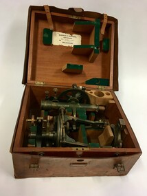
Equipment - Surveying equipment in fitted timber box and leather outer casing
Surveying equipment in fitted timber box. 3 components of solid brass painted dark green. Missing one additional component. Outer fitted and hand tooled leather carrying case.Surveying equipment in fitted timber box. 3 components of solid brass painted dark green. Missing one additional component. Outer fitted and hand tooled leather carrying case.T.005 Ass.No.108B From Norman H.Seward, Optician 459 Bourke St (near Queen St.) Melbourne -
 Bendigo Military Museum
Photograph - Group Photos - Army Headquarters Survey Regiment, Fortuna, Bendigo, c1950s to 1960s
This is a collection of three photographs taken at the Army Headquarters Survey Regiment, Fortuna Villa, Bendigo, circa 1950s to 1960s. Personnel are not unidentified.This is a collection of three group photographs taken at the Army Headquarters Survey Regiment, Fortuna Villa, Bendigo, circa 1950s to 1960s. The photographs were printed on photographic paper and are part of the Army Survey Regiment’s Collection. They were scanned at 300 dpi. .1) - Photo, black and white, 1950s. Group photo of unidentified personnel by Fortuna’s lake. .2) - Photo, black and white, 1950s. Group photo of unidentified personnel at a wind up party. .3) - Photo, black and white, 1960s. Group photo of unidentified personnel by Fortuna’s lake.Personnel are not identified. Photo .2P. is annotated ‘Wind up party’.royal australian survey corps, rasvy, army survey regiment, army svy regt, fortuna, asr -
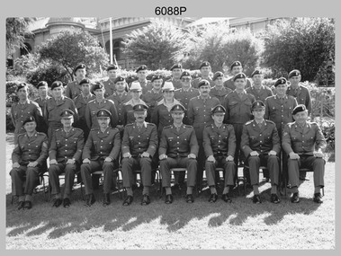
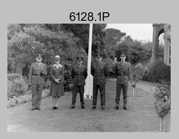 Bendigo Military Museum
Photograph - Senior Leadership – Army Survey Regiment, Fortuna, Bendigo, c1986
These two photos were taken in front of the flagpole at the Army Survey Regiment, Fortuna probably in 1986. LTCOL Don Swiney MBE was appointed as CO of the Army Survey Regiment from 1985 to 1987. He was subsequently promoted to Colonel and was Director of the Royal Australian Survey Corp from November 1988 to January 1991, and the honorary position as Colonel Commandant from January 1993 to January 1996. WO1 Jeff Lynch’s appointment period as RSM was 1986 to 1988.This is a set of two photographs of the Survey Regiment’s senior leadership at Fortuna, Bendigo, 1986. The photographs were on 35mm negative film and were scanned at 96 dpi. They are part of the Army Survey Regiment’s Collection. .1) - Photo, black & white, 1986, L to R: RSM - WO1 Jeff Lynch, LT Alison Black, MAJ Terry Edwards, CO – LTCOL Don Swiney MBE, CAPT Andrew McLeod. .2) - Photo, black & white, 1986, L to R: RSM - WO1 Jeff Lynch, LT Alison Black, MAJ Terry Edwards, CO – LTCOL Don Swiney MBE, CAPT Andrew McLeod.No personnel are identifiedroyal australian survey corps, rasvy, army survey regiment, army svy regt, fortuna, asr -
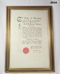 Bendigo Military Museum
Certificate - FREEDOM OF ENTRY, FRAMED
Certificate of Freedom of entry to Bendigo granted to A.H.Q Survey Regt. Signed by JCH Jeffrey, Mayor.Certificate and frame. Frame - gold tinted wooden frame, rectangular, glass. Certificate - Parchment, white, printing possibly old gothic style, black ink. City of Bendigo seal is red and embossed. Survey Regiment crest and City of Bendigo crest. bendigo, survey regiment, svy, freedom