Showing 405 items
matching topography
-
 Lakes Entrance Regional Historical Society (operating as Lakes Entrance History Centre & Museum)
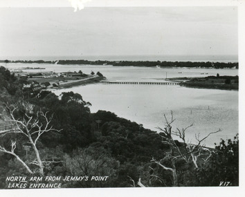
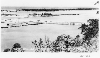
Postcard, Valentine Series, 1930c
This is the before paired photograph used in the 150 year Lakes Entrance 1858-2008 display.|The after paired photograph number is 01590.1|Also one 12 x 16 framed photograph used in room display.Black and white small format postcard of North Arm and Cunninghame Arm of Gippsland Lakes, taken from Jemmys Point, Club Hotel at western end of town, bridge to Bullock Island, scrub covered hummocks and Bass Strait in distance. Lakes Entrance VictoriaNorth Arm from Jemmys Point Lakes Entrancebridges, islands, waterways, topography -
 Lakes Entrance Regional Historical Society (operating as Lakes Entrance History Centre & Museum)
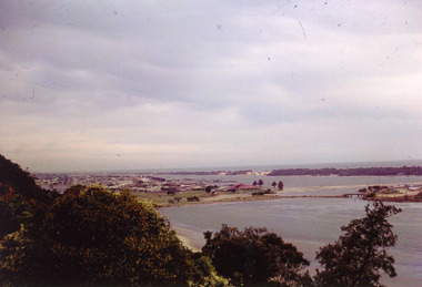
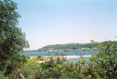
Photograph, Nelson Joan, 1975c
Colour photograph of the township, taken from Jemmys Point. It shows the causeway and raised bridge to Bullock Island, scrub covered sand hummocks and Bass Strait in distance. Lakes Entrance Victoriaislands, waterways, topography, land reclamation -
 Lakes Entrance Regional Historical Society (operating as Lakes Entrance History Centre & Museum)
Photograph, Fraser Ian, 1975c
Color photograph of the eastern part of Bullock Island, showing buildings of Lakes Entrance Fishing Co-Operative and PWD, spit opposite Club Hotel has been sown with grass, hummocks and Bass Strait in distance. Taken from Seaview Parade Kalimna. Lakes Entrance Victoriawaterways, islands, land reclamation, topography -
 Lakes Entrance Regional Historical Society (operating as Lakes Entrance History Centre & Museum)
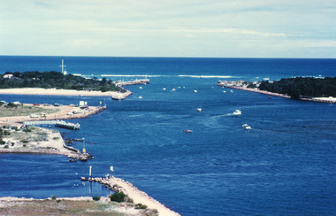
Photograph, Fraser Ian, 1995c
Colour photograph of the entrance from Bass Strait to the Gippsland Lakes. It shows the western end of Bullock Island and the entrance to North Arm, cars parked on island and many people fishing. This area built up during dredging operations over many years. Lakes Entrance Victoriaislands, topography, fishing industry, land reclamation -
 Lakes Entrance Regional Historical Society (operating as Lakes Entrance History Centre & Museum)
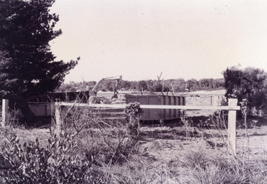
Photograph, Fish Marie, 1995
Black and white photograph of the site of Peck's fish processing factory on Bullock Island. It shows a heavy machine in background, broken concrete and rubbish skip in foreground, site cleared for TAFE education complex. Lakes Entrance Victoriaislands, waterways, dredging, topography -
 Lakes Entrance Regional Historical Society (operating as Lakes Entrance History Centre & Museum)
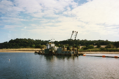
Photograph, 1998
Color photograph of Bullock Island. It shows the dredge Sandpiper working in Cunninghame Arm on the southern shore of Bullock Island. Dredged sand in background on island from previous dredging operations, Kalimna Heights and Jemmys Point in the background. Lakes Entrance Victoriaislands, topography, waterways, public works -
 Lakes Entrance Regional Historical Society (operating as Lakes Entrance History Centre & Museum)
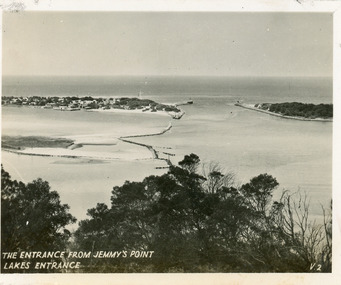
Postcard, 1940c
Originally in a pack of miniature postcards produced for sale to tourists.Black and white small format postcard of the Western end of Bullock Island, Reeves and Entrance Channels, the Entrance and Carpenter Town at the New Works. Taken from Jemmys Point, it shows rock groynes built to channel water flow to the Entrance. Lakes Entrance VictoriaThe Entrance Jemmys Point Lakes Entrance V2jetties, people, topography, boats and boating -
 Lakes Entrance Regional Historical Society (operating as Lakes Entrance History Centre & Museum)
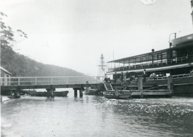
Photograph, 1920c
Black and white photograph of the steamer Gippsland leaving the Kalimna Jetty Gippsland Lakes Victoria. It shows the steep cliffs of Jemmys Point Bullock Island and entrance in the background. Lakes Entrance VictoriaKalimna Cove and Jetty Gippsland Lakesjetties, navigation, topography, boats and boating -
 Lakes Entrance Regional Historical Society (operating as Lakes Entrance History Centre & Museum)
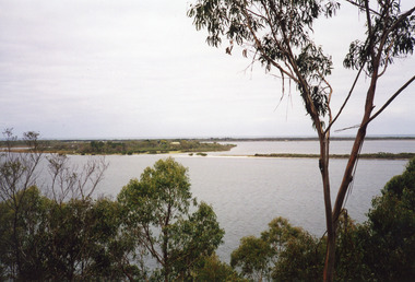
Photograph, Davies, Judy, 2005c
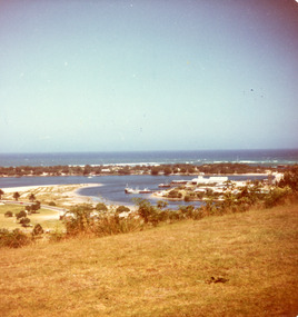
Colour photograph of Jemmys Point, Kalimna Heights, and the Western end of the township, taken from the southern shore of Cunninghame Arm. Small sand spit and natural vegetation in foreground. Lakes Entrance Victoriajetties, waterways, topography, township -
 Lakes Entrance Regional Historical Society (operating as Lakes Entrance History Centre & Museum)
Photograph, 1930c
Black and white photograph of the steamer Gippsland at Nyerimilang Jetty, Gippsland Lakes. Jetty has navigation light but no storage shed at this time. Three smaller boats moored at jetty. Lakes Entrance Victoriaislands, waterways, topography, parks -
 Lakes Entrance Regional Historical Society (operating as Lakes Entrance History Centre & Museum)
Photograph, Holding M, 2000c
Colour photograph of Fraser Island, Gippsland Lakes, taken from Nyerimilang. It shows Flannagan Island mid centre, residence on Fraser Island, scrub covered dunes of southern shore of lake system. Lakes Entrance Victoriarestaurant, waterways, topography, boats and boating -
 Lakes Entrance Regional Historical Society (operating as Lakes Entrance History Centre & Museum)
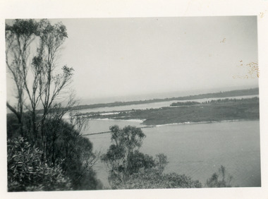
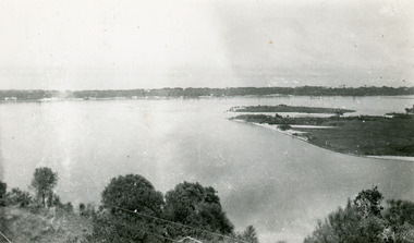
Photograph, 1950c
Also two other copies 7 x 11Black and white photograph showing eastern end of Rigby Island, Snake Island, and dunes at Lakes Entrance, Victoria. Reeves River below, foreground bushes, Hopetoun Channel in middle distance, Bass Strait in distance.jetties, houses, waterways, topography -
 Lakes Entrance Regional Historical Society (operating as Lakes Entrance History Centre & Museum)
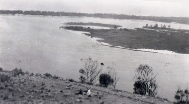
Photograph, 1930c
Black and white photograph, showing eastern end of Rigby Island, Snake Island, at Lakes Entrance, Victoria. Reeves Channel below foreground hill, Hopetoun Channel between dunes and islands with fish pens in distance. Two people sitting on hill in foreground.islands, waterways, topography, room display -
 Lakes Entrance Regional Historical Society (operating as Lakes Entrance History Centre & Museum)
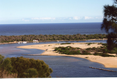
Photograph, 1930c
Black and white photograph, showing eastern end of Rigby Island, Snake Island, at Lakes Entrance, VictoriaBlack and white photograph, showing eastern end of Rigby Island, Snake Island, at Lakes Entrance, Victoriaislands, waterways, topography, room display -
 Lakes Entrance Regional Historical Society (operating as Lakes Entrance History Centre & Museum)
Photograph, 1930c
Black and white photograph, showing eastern end of Rigby Island, Snake Island, at Lakes Entrance, VictoriaColour photograph, showing eastern end of Rigby Island, Snake Island, at Lakes Entrance, Victoriaislands, waterways, topography, room display -
 Lakes Entrance Regional Historical Society (operating as Lakes Entrance History Centre & Museum)
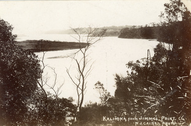
Postcard, Caire Nicholas John, 1905c
Also black and white enlargement 16 x 25Black and white postcard of the lake below Jemmys Point, Gippsland Lakes, showing Rigby Island opposite the steep cliffs of Kalimna and Nungurner shores of lakes. Small island, known as the Doughboy of Rigby Island. View taken from Jemmys Point with natural vegetation in foreground. Lakes Entrance VictoriaKalimna from Jimmys Pointislands, waterways, topography, boats and boating -
 Lakes Entrance Regional Historical Society (operating as Lakes Entrance History Centre & Museum)
Postcard, 1930c
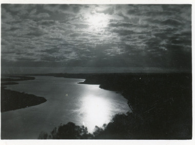
3 identical 6 x 8.5|1 same size hand tinted 6 x 8.5Black and white small format postcard of a sunset scene on Reeves Channel, Gippsland Lakes. It shows sunlight reflected through clouds and on the lake between Rigby Island and the mainland. Lakes Entrance Victoriaislands, waterways, topography, ships and shipping -
 Lakes Entrance Regional Historical Society (operating as Lakes Entrance History Centre & Museum)
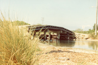
Photograph, Fish Marie, 1965
Also one other photograph, similar viewColour photograph of the first road bridge from Lakes Entrance to Bullock island, which was built for Public Works Dept. groyne building and sand build up to enlarge the island. Built early 1953. Lakes Entrance Victoriawaterways, topography, transport, room display -
 Lakes Entrance Regional Historical Society (operating as Lakes Entrance History Centre & Museum)
Photograph, Lakes Post Newspaper, 1999
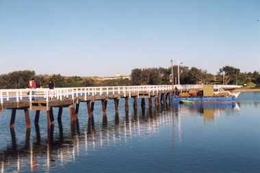
Image appeared in Lakes Post 19 May 1999|Also two other photographs similarColour photograph of repairs to the Cunninghame Arm Footbridge, shows Burys Slipway barge and workmen. Surf Lifesaving Clubroom on dunes in distance. Lakes Entrance Victoriabridges, waterways, associations, topography -
 Lakes Entrance Regional Historical Society (operating as Lakes Entrance History Centre & Museum)
Photograph, Lakes Post Newspaper, 1999
Colour photograph of the Cunninghame Arm Footbridge, . Lakes Entrancebridges, waterways, associations, topography -
 Lakes Entrance Regional Historical Society (operating as Lakes Entrance History Centre & Museum)
Photograph, Lakes Post Newspaper, 1999
Colour photograph of the Cunninghame Arm Footbridge, . Lakes Entrancebridges, waterways, associations, topography -
 Lakes Entrance Regional Historical Society (operating as Lakes Entrance History Centre & Museum)
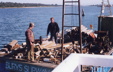
Photograph, Lakes Post Newspaper, 1999
Photo and article appeared in the Lakes Post Newspaper 28 July 1999|Barge was built by Wayne Smith for the firm East Gippsland Bridges.|Also two other photographs similarColour photograph of the launching of a new work barge in the Tambo River, Victoria.boats and boating, topography, waterways, celebrations -
 Lakes Entrance Regional Historical Society (operating as Lakes Entrance History Centre & Museum)
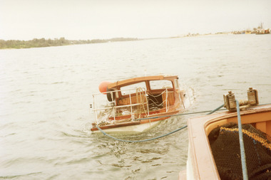
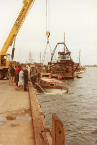
Photograph, 1980
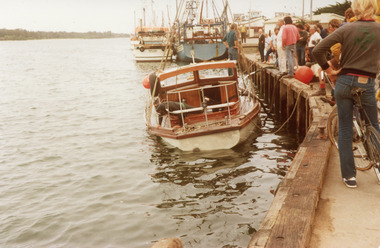
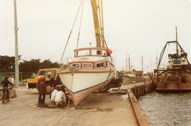
The Idler was recovered by the Ballina Star skippered by Tom Northrope.|Also three other photographs various stages of the recoveryColour photograph of the recovery of the cruiser Idler which had been abandoned at sea, being lifted by the crane up on to the jetty, people on the jetting watching. Lakes Entrance Victoriatopography, fishing industry, ocean, boats and boating -
 Lakes Entrance Regional Historical Society (operating as Lakes Entrance History Centre & Museum)
Photograph, 1980
Colour photograph of the recovery of the cruiser Idler which had been abandoned at seatopography, fishing industry, ocean, boats and boating -
 Lakes Entrance Regional Historical Society (operating as Lakes Entrance History Centre & Museum)
Photograph, 1980
Colour photograph of the recovery of the cruiser Idler which had been abandoned at seatopography, fishing industry, ocean, boats and boating -
 Lakes Entrance Regional Historical Society (operating as Lakes Entrance History Centre & Museum)
Photograph, 1980
Colour photograph of the recovery of the cruiser Idler which had been abandoned at seatopography, fishing industry, ocean, boats and boating -
 Lakes Entrance Regional Historical Society (operating as Lakes Entrance History Centre & Museum)
Photograph, 1975
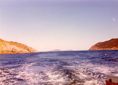
Also second photograph similar unknown location in Bass Strait.Colour photograph of rugged coastline in Bass Strait, taken from fishing boat Minawie. Victoriawaterways, topography, aerial photograph, islands -
 Lakes Entrance Regional Historical Society (operating as Lakes Entrance History Centre & Museum)
Photograph, 1920 Easter
Also a copy of image enlarged number 04225.1 size 10 x 15 cm donated by Marion HoldingBlack and white photograph taken top of steps leading down from Flagstaff to Eastern Pier walkway two women on steps, crane on end of Western Pier Lakes Entrance Victoriabowls club, topography, township, waterways -
 Lakes Entrance Regional Historical Society (operating as Lakes Entrance History Centre & Museum)
Postcard, 1905c
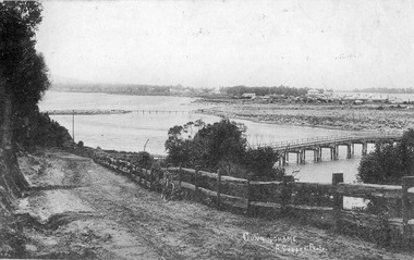
Also Black and white copy 12.5x20.5 Good condition P01146.1Black and white postcard of Cunninghame township, mud flats, North Arm Bridge, wooden bridge to mud island in North Arm, post and rail fence, beside main road. Road appears to have a sand surface. Bicycle leaning against fence. Lakes Entrance Victoriabridges, fences, topography, roads and streets -
 Lakes Entrance Regional Historical Society (operating as Lakes Entrance History Centre & Museum)
Photograph, 1945c
Black and white photograph of view from Kalimna Heights, showing part of the North Arm concrete bridge, Bullock Island and western side of entrance. Truck parked on approach to bridge. Lakes Entrance Victoriatopography, bridges, waterways, transport