Showing 2474 items
matching township
-
 Lakes Entrance Historical Society
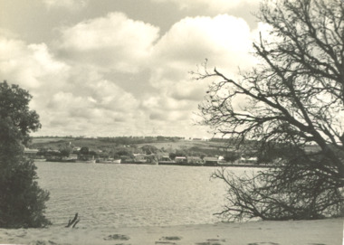
Photograph - Township of Lakes Entrance viewed from Hummocks, L Carpenter, 1952 c
04315.1 and 04315.2 15 x 11 cm and 11 x 15 cmBlack and white photograph of part of the township taken from shore of sand hummocks looking across Cunninghame Arm Lakes Entrance Victoria. Also two black and white photographs of Western part of township taken from sand hummocks across Cunninghame Arm cm and 11 x 15 cmboats and boating, fishing boats, houses, township -
 Lakes Entrance Historical Society
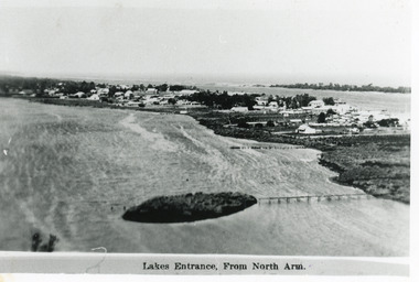
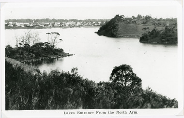
Photograph - Lakes Entrance, 1915c
Other copy 12.5 x 17.5Black and white photograph of the North Arm, showing a mud island in the arm behind the township, Cunninghame Arm, sand hummocks of the southern shore and Bass Strait in distance. Lakes Entrance VictoriaLakes Entrance from North Armtownship, waterways -
 Stawell Historical Society Inc
Photograph, Print of 1870's Lithograph of Stawell, 1870's
View has Artistic Licence probably drawn from an original photograph.Fair print on board backing of view of Stawell from Big HillThe Township of Stawell -
 Kiewa Valley Historical Society
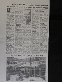
Newspaper Article Copy - Sale of Mt Beauty Town, 1960's
Mt Beauty township was sold in the 1960's after the State Electric Commission of Victoria had finished the construction of the Kiewa Hydro Electric Scheme. The sale of Mt Beauty township signified the end of construction of the Kiewa Hydro Electric Scheme and the beginning of Mt Beauty under the Bright Shire (now Alpine Shire). Many of the workers for the State Electricity Commission of Victoria remained in Mt Beauty and many returned to retire in the town in later years.An A3 sized Photocopy of the newspaper article regarding the sale of the Mt Beauty township with a photo of George Rosen and two houses and an A4 newspaper photocopy of the headline newspaper; mt beauty sale; secv; bright shire -
 Kiewa Valley Historical Society
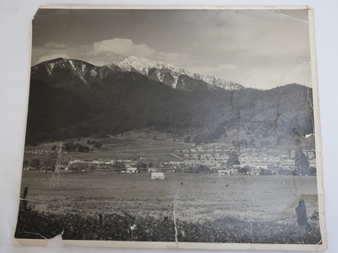
Photo - Mt Beauty c1948, Early photo of Mt Beauty Townhip c1948
Mt Beauty was constructed by the State Electricity Commission of Victoria to house employees of the Kiewa Hydro Electric Scheme. Mt Beauty township looking south east from Hollond's property c1948. Only one transmission line has been built.In the foreground are houses in Simmond's Creek Road. Some houses in North Beauty. The town is still under construction - not all roads have been made and houses haven't any garden around them.This is an early photo of Mt Beauty during construction of the town.d It shows a few houses in Simmonds Creek Road. Large black and white photo of Mt Beauty township with snow on the mountains in the background.mt beauty township 1948, mt beauty construction, simmonds creek road -
Bendigo Historical Society Inc.
Map - HUNTLY, 7/01/1904
Map: Township of Huntly, Parish of Huntly, County of Bendigo ( number 150 in Map Cupboard 1)map, bendigo, township, huntly, parish of huntly, county of bendigo -
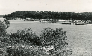 Lakes Entrance Historical Society
Postcard - Lakes Entrance, Bulmer H D, 1950
Black and white postcard of the township of Lakes Entrance, taken form the south bank of Cunninghame Arm, showing the boat haven, buildings along Esplanade, and the Kalimna escarpment in the distance. Lakes Entrance VictoriaLakes Entrance from Ocean Beachtownship, waterways -
Bendigo Historical Society Inc.
Map - FOSTERVILLE MAP, 19/08/1897
Map: Township of Fosterville, Parish of Ellesmere, County of Bendigo. Parish plan (number 277 in map cupboard 1)map, bendigo, township, fosterville, ellesmere -
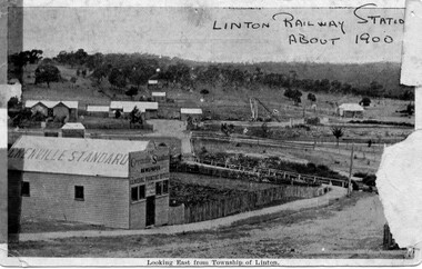 Linton and District Historical Society Inc
Photograph, Grenville Standard and Linton Railway Station buildings, c.1900
The 'Grenville Standard' was Linton's newspaper from 1895-1941. The railway arrived at Linton in 1891. Black and white postcard photograph of view looking east from Clyde Street in Linton township. 'Grenville Standard' building prominent in foreground, railway buildings and machinery, and station-master's house, in middle ground. Hills rising behind, with two or three cottages, and trees."Linton Railway station about 1900" hand printed across top of photograph. "Looking East from Township of Linton" printed beneath picture.grenville standard [newspaper], linton railway station, buildings, station master's house linton -
 Orbost & District Historical Society
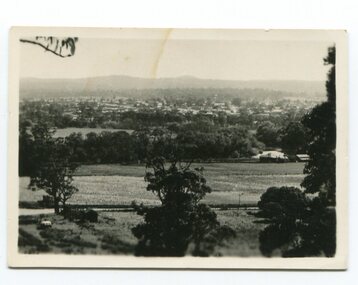
black and white photograph, late 19th / early 20th century?
This photograph shows a distant view of the Orbost township taken from Grandview Lookout at Newmerella. It appears to have been taken before the railway line was there.This is a pictorial record of early Orbost.A small black / white photograph of the Orbost township taken from Grandview Lookout , Newmerella. The main road can be seen below with paddocks of crops on both sides.on back - "Distant View, Orbost from Grandview"orbost-township-c19th grandview-lookout orbost-flats-paddocks -
Whitehorse Historical Society Inc.
Map, Dandenong Ranges Area, 1955
Sheet 13. Parts of Parishes: Nunawading, Mulgrave and Scoresby.Sheet 13. Parts of Parishes: Nunawading, Mulgrave and Scoresby. Includes area of Vermont South marked as proposed Township of Norwich. Scale 10 chains : 1 inch. Contours marked.Sheet 13. Parts of Parishes: Nunawading, Mulgrave and Scoresby. maps, vermont south, wantirna, dandenong creek -
Bendigo Historical Society Inc.
Map - KANGAROO FLAT, 27/.01/1932
Map: Township of Kangaroo Flat, Parish of Sandhurst, County of Bendigo ( number 148 in Map Cupboard 1)map, bendigo, township, kangaroo flat, parish of sandhurst, county of bendigo -
Bendigo Historical Society Inc.
Map - TOWNSHIP OF HEATHCOTE (PART), 11/04/1935
Map: Township of Heathcote (part), Parish of Heathcote, County of Dalhousie. Parish plan (number 259 in map cupboard 1)map, dalhousie, township, heathcote, copunty of dalhousie -
 Stawell Historical Society Inc
Photograph, Pioneers Memorial on Big Hill -- Sunset through its Columns -- Coloured
Looking through Pioneers Memorial Columns. The photo shows the ground floor of the Pioneers memorial with the Corinthian pillars supporting the dome. The directional pedestal is in the center installed in c 1947. The Stawell township is in the background with the sun setting behind the Grampians.Looking through Pioneers Memorial Columns with the directional pedestal in the center. The view shows the Stawell township in the background and the sun setting behind the Grampians.Carol Anne Jonesstawell -
 Hume City Civic Collection
Photograph, c late 1980s
The photograph shows a section of the original settlement of the Bulla township. The cutting on the hillside is significant as it is the remains of one of the original stream crossings in Victoria.A coloured photograph of the Bulla Hill along Sunbury Road with a view of the cutting on the distant hillside. The photograph is a view of the old Bulla township looking to the NW. There is a wide grassy verge in the foreground.bulla township, deep creek, wright, william 'tulip', sunbury road, george evans collection -
 Lakes Entrance Historical Society
Photograph, Lakes Entrance, 1930 c
Black and white photograph taken from north of township looking toward town and front lake and sand dunes. Roadway in middle distance is Myers Street known as Allens Hill in 1930 Lakes Entrance Victoriatownship, roads and streets -
 Stawell Historical Society Inc
Photograph, Panorama of Stawell from Big Hill -- Sunset -- Coloured
Sunset from Big Hill. The photo shows the Stawell township with the Grampians in the background and the sun setting behind the Grampians. The majority of the image is a view of the cloud formation. Photo taken by Carol Anne JonesColour photograph of sunset from Big Hill. The photo shows the Stawell township with the sun setting behind the Grampians. The majority of the image is a view of the cloud formation.Carol Anne Jonesstawell -
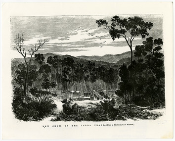 Marysville & District Historical Society
Work on paper (item) - Print of wood engraving, Frederick Grosse et al, New Chum on the Yarra Track, 27-09-1866
A copy of an early wood engraving taken from a photograph of the deserted township of New Chum, near Healesville, on the Yarra Track in Victoria.A copy of an early wood engraving taken from a photograph of the deserted township of New Chum, near Healesville, on the Yarra Track in Victoria. The Yarra Track is the former name of the gold fields road from Healesville to the Woods Point and Jordan Goldfields in Victoria.new chum, healesville, yarra track, victoria, frederick grosse, albert charles cooke, thomas waters, wood engraving -
Lakes Entrance Historical Society
Book, Cannon Michael, Vagabond Country
An account of journey through Gippsland, during 1880's by vagabond- John Stanley James journalist, also known as Julian Thomas, giving his comments on the settlers, businesses and townships, also problems of isolation.Edited by Michael Cannonhistory, township -
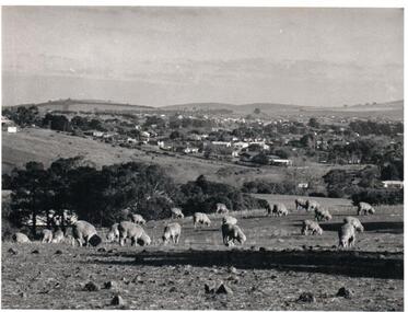 Hume City Civic Collection
Photograph, Early 1970s
The photograph was taken when Sunbury township did not extend far beyond Anderson Road to the west and Powlett Street to the east. The Paynes housing development can be seen scattered across the hillside between Gap Road and Mitchells Lane.A black and white photograph of a panoramic view of Sunbury township looking west and taken from above the Goonawarra Winery. Sheep are grazing on the hilside in the foreground.sunbury township, goonawarra winery, george evans collection -
Lakes Entrance Historical Society
Book, Judy Hartley, Nowa Nowa A Journey through the First 100 Years, 2018
A collection of photographs facts and history from the proclamation of the settlement and township in the Victorian Gazette of December 1888 until becoming the thriving community in 1988 Nowa Nowa East Gippsland Victoriatownship, timber industry, railways -
Bendigo Historical Society Inc.
Map - TOWNSHIP OF HEAHCOTE SHEET 1, 29/07/1935
Map: Township of Heathcote sheet 1, parish of Heathcote, County of Dalhousie. Parish plan (number 253 in map cupboard 1)map, dalhousie, township, heathcote, conty of dalhousie -
Lakes Entrance Historical Society
Book, McMahon, David and Fitzclarence, Eunice, Rob the Milkman - Robert Hamilton McMahon, 2009
An edited account of the diary of Robert Hamilton McMahon written 1917-1918, when he served as 'milkman' for the township of Lakes Entrance and associated settlements, from his dairy herd on Rigby Island and the Barrier, Gippsland Lakes, Victoria.township, land settlement -
Lakes Entrance Historical Society
Book, Gippsland Heritage Journal - issue 25, 2001
Issue 25 of a series contains articles on Point Hicks lighthouse Buchan Caves Reserves, Mental Health in early Gippsland, Mallacoota, Gould township, 1840 diary of Matthew Macalister Photographs.township, lighthouses, photography -
 Lakes Entrance Historical Society
Photograph - Lakes Entrance, Nelson Joan, 1975c
Colour photograph of the township, taken from Jemmys Point. It shows the causeway and raised bridge to Bullock Island, scrub covered sand hummocks and Bass Strait in distance. Lakes Entrance Victoria waterways, topography, township -
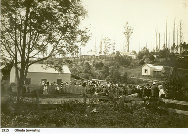 Mt Dandenong & District Historical Society Inc.
Photograph
1915 Olinda Township -
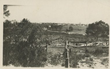
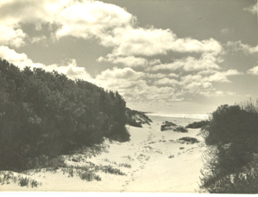 Lakes Entrance Historical Society
Photograph - Track at sand hummocks Lakes Entrance Victoria
track through vegetation and sand hummocks with distant ocean view. Part of western end of township across Cunninghame Arm in distance Lakes Entrance VictoriaBlack and white photograph showing track through vegetation and sand hummocks with distant ocean view. Part of western end of township across Cunninghame Arm in distance Lakes Entrance Victoriatopography, beach, ocean -
 Lakes Entrance Historical Society
Photograph - Lakes Entrance, 1940c
Black and white photograph of the township from the North Arm. It shows the calm waters between steep shorelines covered in natural vegetation and scrub. Lakes Entrance VictoriaLakes Entrance from the North Armvegetation, topography, waterways, township -
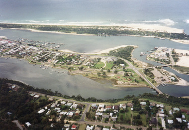 Lakes Entrance Historical Society
Photograph - Lakes Entrance, 1997c
Colour print of aerial view looking south of western side of township. Shows housing on Kalimna Hill, North Arm, part of Bullock Island, Cunninghame Arm, the outer barrier and east pier of man made entrance. Lakes Entrance Victoriawaterways, township -
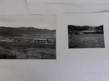 Kiewa Valley Historical Society
Photos x2 - Views of Mt Beauty
The State Electricity Commission of Victoria constructed the Mt Beauty township as part of their construction of the Kiewa Hydro Electric Scheme.Historic photos of the development of the Mt Beauty township2 B & W Photos. 1. Large - early photo of houses in front of pondage (taken for what is now the golf course). 2. Medium size - looking south towards Mt Beauty township with Mt Arthur in the backgroundOn back.1. Laurie Richards No. LH 1405 2. Laurie Richards No. Copy 518mt beauty township, laurie richards