Showing 309 items
matching urban planning
-
 Melbourne Tram Museum
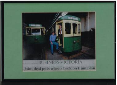
Photograph - Framed Photographs, Business Victoria, "Business Victoria - Joint deal puts wheels back on tram plan", Sep. 1999
Framed photograph - metal frame, cardboard backing, light green card window mat, of Mike Ryan (VicTrack) as Project Manager for the redevelopment of the Hawthorn Tram depot and Matt Faubel of the Urban Land Corporation for The Age newspaper article titled "Business Victoria - Joint deal puts wheels back on tram plan", 13/9/1999. On the rear of the frame is a photocopy of the article. Photographed on tram 180, with 610 alongside and a photograph of the Hawthorn depot. See also Reg item 2726.2 for an associated newspaper cutting and 2726.6trams, tramways, victrack, hawthorn tram depot, reconstruction, tram 180, tram 610 -
 Melbourne Tram Museum
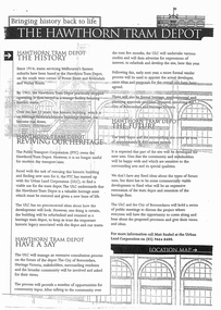
Document - Report, Minister of Transport, "Bringing history back to life - The Hawthorn Tram Depot", Aug. 1998
Report - consultation document titled - "Bringing history back to life - The Hawthorn Tram Depot", 7 A4 sheets, photocopied, outlining the joint Public Transport Corporation (PTC) and Urban Land Corporation (ULC) study into the future of the Hawthorn Tram Depot. Includes a site plan or location map, consultation proposals, news release from the Minister for Transport - Mr Robin Cooper - dated 12/8/1998 and background document providing details of some of the heritage trams - both the PTC and the TMSV. Two copies held - one stapled. Imaged as a pdf file.trams, tramways, hawthorn depot, heritage, minister for transport, tram depot -
 Bacchus Marsh & District Historical Society
Map, Plan of the second portion of the property of Messers Atkins and Clarke situate at Bacchus Marsh 1856
This plan of land allotments for sale indicates part of the property once owned by the Bacchus family in and around the township area of Bacchus Marsh. The Bacchus family sold their property in Bacchus Marsh to John Aitkins and Robert Nalder Clarke in March 1851. Aitkins and Clarke kept the property for a number of years until April 1856 when these allotments were put up for sale.This is a very early land sales plan for agricultural land close to the township of Bacchus Marsh. It therefore provides some clues as to how the early urban development of the township and agricultural development of the nearby area took place. Upon seeing the map in 1911 Bacchus Marsh Express newspaper editor Christopher Crisp wrote "The sale appears to have created the present township, which had a nucleus in earlier times further east", Express, 30 September, 1911, page 3.A single page paper plan showing allotments of land for sale. The subdivided land shown was owned by John Aitkins and Robert Nalder Clarke, but previously owned by the Bacchus Family and was in and around their Manor House (Mansion) property in Bacchus Marsh. This plan shows allotments in the second portion of land to be sold which was located east of the Manor House on the eastern side of the Lerderderg River. The land for sale was made up of 15 allotments. The plan is pasted into a bound volume containing 76 maps or plans in total. BMDHS Loc: AR/B12/S4 Bacchus Marsh Township and Nearby Districts Maps Volume In-house Digital copies: BMDHS, Computer Network: Maps\Bacchus Marsh Township and Nearby Districts Maps Volumebacchus marsh victoria maps, bacchus family, land sales, manor house bacchus marsh -
 Ballarat Tramway Museum
Document - Evidence, City of Geelong, "Geelong City Council", 1953
Evidence or submission by the Geelong City Council for the Enquiry into Public Transport Facilities in the Geelong Urban District" to the Transport Regulation Board, Sept. 1953, presented by Cr B E Purnell. Document addresses issues with buses, trams, railways, hire cars, taxis, Bell Report of 1948 and other matters to be considered. Included is 7 page submission by Geelong and District Town Planning Committee looking at the function of the scheme, relationship with transport authorities, traffic census, transport issues in specific suburbs, road proposals, and town planning.Demonstrates evidence given to the TRB re Geelong transport and town planning in 1953.Document - 10 foolscap sheets, duplicated, stapled in top left hand corner.tramways, tramcars, geelong, history, city of geelong, roads, trb -
 Ballarat Tramway Museum
Document, Hector Bell Junior, "Street passenger transport system of Geelong Urban Area", 1949
Report by Hector H Bell Junior of the MMTB early 1949, titled "Street passenger transport system of Geelong Urban Area". Looks at the history of public transport in Geelong, tramway data, financial analysis, the Geelong bus system, buses servicing the North Shore industries - principally the Ford Works, the condition of the bus fleet, taxi and private car hire services, functions of a street transport authority, town planning, populations and traffic surveys, relative values of passenger vehicles, trolley buses, industry and recommendations. Said the tramway system was obsolete, should be a rail service between North and South Geelong, set up a street transport body, replan the Geelong railway station, additional roads to service the North Shore area. Refers to attachments. Has a list of people involved in the preparation of the report. See item 112 for the AETA response of April 1949 to this report.Yields information about the Geelong tram and bus services in 1948/49 and how it could be developed or reformed. Has a close association with Hector Bell Junior, the son of the then MMTB Chairman.Document - 18 foolscap sheets photocopied and stapled in three places along the side.tramways, secv, geelong, statistics, history, passenger services, reports, aeta -
 Bacchus Marsh & District Historical Society
Map, Plan of the property of Messers Atkins and Clarke to be sold at the Mansion, Bacchus Marsh 19th April 1856. Copy 1
This plan of land allotments for sale indicates the property once owned by the Bacchus family in and around the township area of Bacchus Marsh. The Bacchus family sold their property in Bacchus Marsh to John Atkins and Robert Nalder Clarke in March 1851. Atkins and Clarke kept the property for a number of years until April 1856 when these allotments were put up for sale.This plan is almost identical to another copy held by the Bacchus Marsh and District Historical Society, VC Record 452, BMDHS collection). This plan, VC Record 707 Copy 1, contains a little more detail overall than VC Record 452 Copy 2, such as who did the survey work for the plan (R.C. Bagot) and who the selling agents were, (W.M. Tennent), and on the right side of the plan near the Lerderderg River is indicated the general area for a second parcel of land from this sale which is to be sold. There is also a compass illustration indicating north and south compass points.This is a very early land sales plan for the township of Bacchus Marsh and it therefore provides some clues as to how the early urban development of the township took place. Upon seeing the map in 1911 Bacchus Marsh Express newspaper editor Christopher Crisp wrote "The sale appears to have created the present township, which had a nucleus in earlier times further east", Express, 30 September, 1911, page 3.A single page paper plan showing allotments of land for sale. The subdivided land shown was owned by John Atkins and Robert Nalder Clarke, but previously owned by the Bacchus Family and was in and around their Manor House (Mansion) property in Bacchus Marsh.There are 5 portions of land further divided into numerous small portions. The land for sale is bounded by the present day streets of Main Street, Young Street, McFarland Street, Morton Streets, Crook Street, and part of the eastern section extends to the Lerderderg River. Scale: 8 chains to 1 inch The plan is pasted into a bound volume containing 76 maps or plans in total. BMDHS Loc: AR/B12/S4 Bacchus Marsh Township and Nearby Districts Maps Volume In-house Digital copies: BMDHS, Computer Network: Maps\Bacchus Marsh Township and Nearby Districts Maps VolumeHeading: Plan of the first portion of land. The property of Messers Atkins and Clarke situate at Bacchus Marsh. To be sold by W.M. Tennent & Co. at the Mansion on the Ground on Saturday the 19th April 1856. Below heading: Jas Ferguson, Lithographer On upper right side: Subdivided by R.C. Bagot London and Liverpool Chambers, Melbourne. 'Thos Taubman'. Post Office Stamp: BACCHUS MARSH VICTORIA MY 6, 63bacchus marsh victoria maps, bacchus family, land sales, manor house bacchus marsh -
Lakes Entrance Historical Society
Book, Perrott Lyon Mathieson Pty. Ltd, Lake Tyers Beach and Surrounds Strategy Plan, 1991
... and surrounding area prior to future planning with regard to urban... of the Lake Tyers Beach and surrounding area prior to future planning ...A commissioned study of the Lake Tyers Beach and surrounding area prior to future planning with regard to urban development, tourism and conservation of natural beauty. Contains illustrations and a plan of proposed boat ramps.waterfront, township, tourism -
Port Melbourne Historical & Preservation Society
Book, Kate Shaw et al, Ewan Ogilvy's Bayside Papers, Box Three - Bayside Views - A Collection of critical perspectives on the Bayside Development, 1988
Ewan OGILVY, former Melbourne Councillor and also of Community Services Victoria, Inner Urban Ministerial Advisory Committee and Uniting Church's Centre for Urban Research and Action (CURA), was instrumental in social justice approaches to town planning. He and CURA's Social Justice and the City Project funded Port Melbourne community groups protesting against the SCDC development in 1987. His files were presented to the Society in May 2001 on his preparation for leaving Victoria.From Ewan OGILVY'S chronologically organised 'Bayside Papers' relating to the proposed development of Port Melbourne industrial land in the late 1980s: Bayside Views - A Collection of critical perspectives on the Bayside Development, a book of essays on Bayside issues, 1988 - funded by the Justice in the City projectSigned 'Ewan Ogilvy'town planning, town planning - proposals shelved - bayside, public action campaigns, environmental issues, public housing, missions to seamen, centre for urban research and action (cura), uniting church, sandridge city development co pty ltd, scdc, linton r lethlean, barry pullen, ewan ogilvy -
 Eltham District Historical Society Inc
Document - Property Binder, 616 Main Road, Eltham; Plum Cottage
Plum Cottage is covered by Heritage Overelay HO256 in the Nillumbuk Planning Scheme This two-lot land holding was created as a subdivision and sold to Charles Stuart McNeil by May 1955. Sometime in the period 1955-1960, the builder-designer, John Harcourt had created a pise house on the site, straddling the two subdivision lots. The designer, John M. Harcourt was a pioneer builder in pise-de-terre and mudbrick in the Eltham Shire, Eltham being synonymous with alternative lifestyles and building practises until the onset of suburbia in the late 20th and early 21st centuries. This hipped-roof house is set high above Main Road on a V-shape plan characteristic of the Arts & Crafts style, with rammed earth or pise walls, timber joinery and a cement tiled roof. The V shape plan was used by important English and Eltham Arts & Crafts designers. The use of natural materials such as stone and timber construction is an essential part of the Arts & Crafts style and Harcourt’s work. So too is the application of the style on both the exterior and interior of the house as a holistic concept. The house adjoins the Lim Joon adobe house built and designed by Alistair Knox in the same era (HO119), thus forming a distinctive pair, both using an uncommon plan form. This house was identified in the Shire of Shire of Eltham Heritage 1992 as contributory to the Eltham Gateway Conservation Area, then proposed as an urban conservation area (now Heritage Overlay Area). Land Ownership Emily Jane Smith of 12 Woodside Street Fitzroy owned Crown Allotments 1 & 2 Sections 14, 27 by August 1918, selling to William Henry Smith of 12 Woodside Street, Nth Fitzroy May 1921. (John) James Isherwood of Main Road, Eltham owned the property by 1928 (the year of his death) with the beneficiary of his estate and next owner of this site being his widow, Minnie Maria Isherwood of Cemetery Road, Eltham. His holding in Main Road included parts of what was described in rate records as allotments1 & 2 Section E6. In the late 1930s, early 1940s her son Alfred John Isherwood was also rated for the land around this site, with the rated nett annual value varying between £2 and £5. Alfred Isherwood also lived at Main Road, Eltham with his wife Ellen: her early death at the age of 24 was reported in the Argus of 1923. Part of the Isherwood land was divided off and sold to Charles Stuart McNeil by May1955. Sometime in the period 1955-1960, the builder-designer, John Harcourt had created a pise house on the site, straddling the two subdivision lots. The house is visible on an aerial photograph from 1960s. Reputedly the house was called Plum Cottage and erected for Harcourt’s mother-in-law. A garage was added in 1959. Charles McNeil died in1971 aged 87: he was the son of Don McNeil and Margaret Arkell. Available rate records from the construction era start in the of the 1970s (1972-3) and list Mr H.C. & M/S A.V. Charity at 616 Main Road Eltham of this property with a nett annual value of $740. More recent valuer's data describes the property as lots 1 & 2 LP25668, located in the Central Riding of Eltham Shire, owned by Ann Valerie Charity and later, in 1990, by the Chincarini family. Building Description This hipped roof 11 .5 square house is set high above Main Road on a characteristic-shape plan and has rammed earth or pise walls, timber joinery and a cement tiled roof. The V-shape plan was used by Important designers such as C.F.A. Voysey (UK) who interpreted medieval domestic architecture as part of the Arts & Crafts style of the late 19th and early 20th centuries. The pise walls are covered with a textured render while the cement roofing tiles are also seen in the Harcourt Hill examples. Reputedly the ceiling joists are of a deep section and span long lengths with no need for hanging beams in the roof space. The ceilings are low and panelled in main rooms with apparently Caneite soft board infill panels between the exposed ceiling beams. These are painted white but may have been stained at one time. The focus of the house is the large living area with its vast random stone fireplace. Significance Plum Cottage is significant to the locality of Eltham because: Historically: • Plum Cottage is closely associated with the important historical theme of earth construction evident in Eltham and elsewhere in the Shire since theear1y Arts & Crafts inspired creations at Penleigh Boyd's The Robins (1912, HO101) and those at Montsalvat (1934-, HO82) but more prominent from the Second War period when earth building in Eltham was promoted in national periodicals as an alternative building method that avoided the building materials shortages of that era; • The choice of the earth building technique also expresses the theme of refuge or alternative living, synonymous with Eltham in the early to mid 20th century; • as a good example of domestic architecture from John Harcourt who was the first major post Second War figure in an important phase of Eltham’s earth building development, using his characteristic Old English or Arts& Crafts style that relies in this case on the pise wall construction, pitched roof forms, exposed ceiling joists, half timbering, random stonework, and panelled internal wall finishes. Architecturally: • Plum Cottage's pise wall construction is uncommon among the early earth-walled structures in the Shire, that are mainly of adobe or mud brick, and as a building material is uncommon among the Shire’s suburban dwellings generally which are clad typically with either fired clay bricks or timber boarding. Aesthetically: • Plum Cottage is a good and well preserved example of a modern Old English or Arts & Crafts style earth-walled building in the Shire • For the proximity of the significant Lim Joon adobe house designed by Alistair Knox adjoining to the north, providing a distinctive earth wall house pair, with uncommon plan forms. Reference Heritage Assessment of Plum Cottage, 616 Main Road, Eltham; Graeme Butler & Associates 2010main road, eltham, property, houses, (john) james isherwood, alfred john isherwood, ann valerie charity, arts and crafts style, charles stuart mcneil, chincarini family, eltham gateway zone, emily jane smith, h.c. charity, heritage assessment, john harcourt, john m. harcourt, lim joon house, main road eltham, minnie maria isherwood, pise construction, plum cottage