Showing 17881 items
matching view-master
-
 Eltham District Historical Society Inc
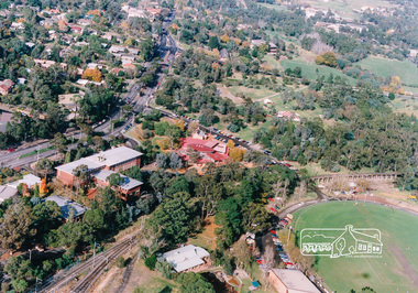
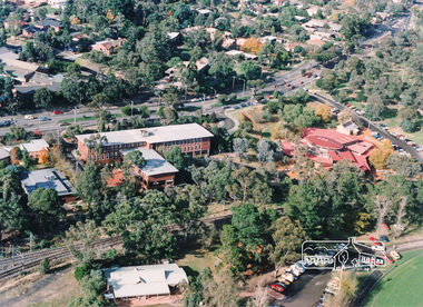
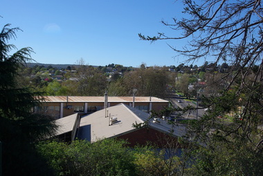
Photograph, Aerial view of Eltham Shire Office and Eltham Library precinct, 1994, 1994
Colour photograph of oblique aerial view centred on Eltham Library, 1994eltham, eltham library, eltham shire offices, eltham central park, alistair knox park, main road, aerial photographs -
 Eltham District Historical Society Inc
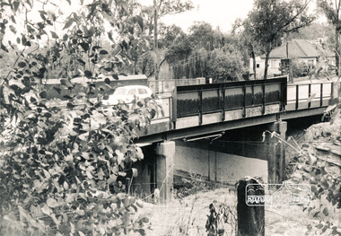
Photograph, Mountain View Road railway bridge, Montmorency
Black and white photograph of railway bridge, Mountain View Road, Montmorencybridges, railways, mountain view road, montmorency -
 Victorian Interpretive Projects Inc.
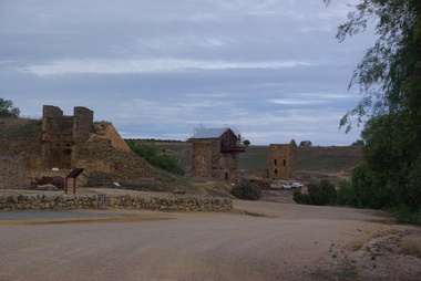
Photograph - Colour, Clare Gervasoni, View from Burra Lookout, South Australia, 29/05/2013
Burra is a town in South Australia's Copper triangle. View of mining remnants at Burra, South Australia from the Burra Lookout. -
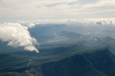
 Stawell Historical Society Inc
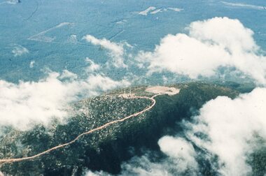
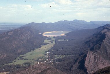
Slide, Ian McCann, Aerial View Grampians & Construction of Bellfield, 1960's
Colour Slide; aerial View of Mt William through scattered cloudsgrampians, mt william -
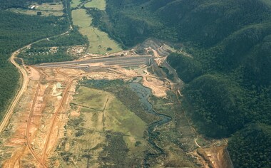
 Stawell Historical Society Inc
Slide, Ian McCann, Aerial View of Grampians Ranges inc Valley, 1960's
Colour Slide: Aerial View of Grampians Showing both Ranges and the Valley grampians -
 Stawell Historical Society Inc
Slide, Ian McCann, Aerial View of Lake Bellfield, 1960's
Colour Slide: Aerial View of Lake Bellfield Looking Up the Valleygrampians, lake bellfield -
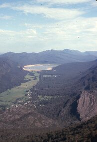
 Stawell Historical Society Inc
Slide, Ian McCann, Ariel View of the Construction of Lake Bellfield, 2022
Ariel View looking up the Valley athte COnstruction of Lake Bellfieldgrampians, lake bellfield -
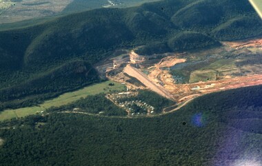
 Stawell Historical Society Inc
Slide, Ian McCann, Ariel View of Lake Bellfied looking down the valley showing the wall, 1960's
Ariel View of Lake Bellfied looking down the valley showing the wallgrampians -
 Whitehorse Historical Society Inc.
Photograph, Aerial View of Site for Nunawading Civic Centre, 12/06/1968 12:00:00 AM
Black and white photo of Aerial View of Site for Nunawading Civic Centre.nunawading civic centre -
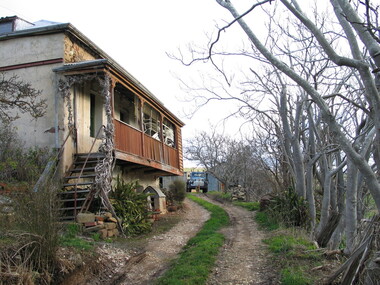 Ballarat Heritage Services
Photograph - Colour, Pine View, Yandoit Creek, 2004, 26/06/2004
Colour photograph of Pine View, the home of Vince Gervasoni, of Yandoit Creek.yandoit creek, yandoit, pine view, vince gervasoni -
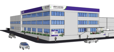 Vision Australia
Drawing - Image, Vision Australia Kensington exterior artists view, 2009
Artist impression of the new building for Vision Australia's office in Macaulay Road, Kensington in 2009.4 digital files depicting artists view of Macaulay Road officevision australia, macaulay road kensington -
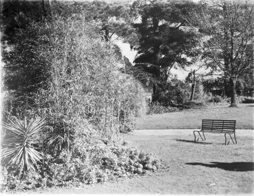 University of Melbourne, Burnley Campus Archives
Photograph - Black and white print, Garden View
Black and white photograph. View adjacent to the Croquet Lawn. Bench on the grass.175 in coloured pencil on reversegarden view, croquet lawn -
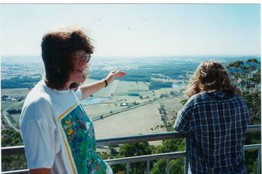 Buninyong & District Historical Society
Photograph - Original Photograph, View from Mount Buninyong Tower, with Ann Beggs Sunter and unknown, Feb. 1995
historic, fire, towerView from Mount Buninyong Tower, with Ann Beggs Sunter and unknown.mount buninyong, fire tower -
 Stawell Historical Society Inc
Slide, Ian McCann, Aerial View of Lake Belfield in the distance, 1960's
Colour Slide: Aerial View of Grampians Valley with lake Bellfield in the distancegrampians, lake bellfield -
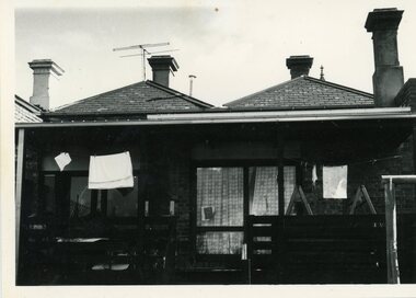 Kensington Neighbourhood House
Photograph - KNH 5/6/006 Rear view of 89 McCracken Street
-
 University of Melbourne, Burnley Campus Archives
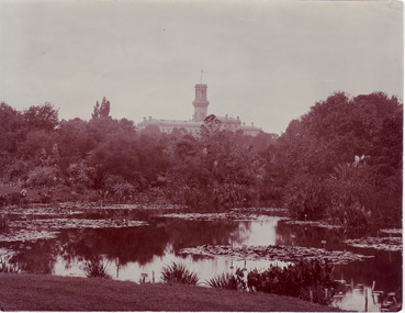
Photograph - Black and white and sepia prints, View of Botanic Gardens, Unknown
Black and white and sepia photographs. Views across the lake towards Government House. (a) Woman sitting on the lawn on the other side of the lake, labels on the plants visible (sepia). (b) Same view with caption, "6 Botanical Gardens." (c) Slightly different view. Photographs B91.409 to B91.417 appear to have come from the same photograph album.On reverse, "Government House - Melb from Botanical Gardens."lake, government house, royal botanic gardens, excursion, botanic gardens, view -
 Mt Dandenong & District Historical Society Inc.
Photograph, View of valley looking south over 'Kalorama' towards falls, 1908
View taken 1908 looking south over 'Kalorama', home of Ellis and Eliza Jeeves, across the valley towards the falls.This photograph has a detailed inscription on the back handwritten by John Lundy-Clarke in 1974.View taken 1908 of valley looking south over “Kalorama” towards the falls. House right of “Kalorama” was Paynter’s “Iona” on Lot 29. Faintly below line of Barber’s Road above “Kalorama” is Logan’s house on Lot 28. House against orchard was Pimm’s later Prince’s Lot 19. Big trees on right were on Price’s Lot 18 and were between Tosari Rd and Rosemont Cres. It was FROM one of these being cut up in 1931 that the round length log weighing ½ a ton got away from the splitters and raced down the hill in bounces, one of which cleared Barber’s Rd and Logan’s house in leaping from the fence line above the road.kalorama, paynter, iona, barbers road, ellis jeeves -
 Ringwood and District Historical Society
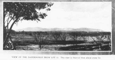
Photograph, Mullers orchard, Heathmont. Looking east from cnr. Canterbury and Dickasons Rds. "Charm View Estate" - 1926
Printed below photograph, "View of the Dandenongs from Lot 11. This view is observed from almost every lot". Written on back of a photograph, "Photo taken from sub. div. plan land sales. Charm View Estate, Heathmont, 1926?" Another copy reads, "Mullers orchard, Heathmont. Taken from cnr. Canterbury and Dickasons Rds. Looking east - 1926". -
 Ringwood and District Historical Society
Photograph, View of Ringwood. circa 1960's
Postcard size coloured photograph"Written on back of photograph" View of Ringwood looking from Laughnans Road,-circa 1960's -
 Eltham District Historical Society Inc
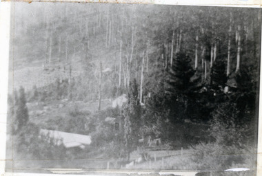
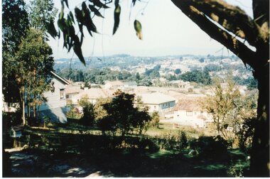
Photograph, Michael Wood, View south from 184 Progress Road to houses on Scenic Crescent, Eltham North, February 1970, 1970
Wood family home (1969-2011) pre and post construction by Knox and HellemonsKodachrome 35mm colour transparency in cardboard mount Processing date FEB70M6Inscribed in ink "View south from 184 Progress to Scenic Crescent, Eltham North 1970"alistair knox design, eltham north, hellemon, houses, progress road, scenic crescent -
 Ringwood and District Historical Society
Photograph, New market - View of goods intake section 'Target'. Ringwood 1982
Written on back of photograph, "E648. 8/1/82. View of goods intake section 'Target'". -
 Ringwood and District Historical Society
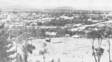
Photograph, A panorama of Ringwood from Mountain View Estate, Loughnan's Hill. (no date)
Typed below photograph, "A Panorama of Ringwood" and written on back of photograph, "Mountain View estate circular". -
 Melbourne Tram Museum
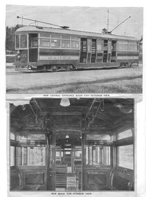
Photograph - Illustration/s, Melbourne & Metropolitan Tramways Board (MMTB), "New Central Entrance bogie car Exterior View", "New Bogie car - interior view", 1921
Illustration - set of two photos that have been glued to a sheet of lined paper. .1 - Top illustration - of L 105, letter M&MTB, route Number 2 - titled "New Central Entrance bogie car Exterior View" .2 - Lower illustration of the interior of the tram - showing bellcords, doors, 3 + 2 seating, seat panels, strap hangers, light fittings, wood panelling, windows, MMTB logos and window lifters - titled "New Bogie car - interior view". Source of the images unknown. See Reg Item 3558 for another print within an album and 7415 for a photo of one of the saloons. trams, tramways, mmtb, new trams, l class, interiors, fittings, tram l 105 -
![View of the Township of Ballan / [by] Nicholas Caire, circa 1876](/media/collectors/550653872162f11fb04854aa/items/578258d3d0cdd1176ce23812/item-media/57825939d0cdd1176ce27694/item-fit-380x285.jpg) Kew Historical Society Inc
Kew Historical Society IncPhotograph, Anglo-Australasian Photographic Company, View of the Township of Ballan, c. 1876
Nicholas Caire was born on Guernsey in the Channel Islands in 1837. He arrived in Adelaide with his parents in about 1860. In 1867, following photographic journeys in Gippsland, he opened a studio in Adelaide. From 1870 to 1876 he lived and worked in Talbot in Central Victoria. In 1876 he purchased T. F. Chuck's studios in the Royal Arcade Melbourne. In 1885, following the introduction of dry plate photography, he began a series of landscape series, which were commercially successful. As a photographer, he travelled extensively through Victoria, photographing places few of his contemporaries had previously seen. He died in 1918. Reference: Jack Cato, 'Caire, Nicholas John (1837–1918)', Australian Dictionary of Biography.An original, rare photograph from the series 'Views of Victoria: General Series' by the photographer, Nicholas Caire (1837-1918). The series of 60 photographs that comprise the series was issued c. 1876 and reinforced a neo-Romantic view of the Australian landscape to which a growing nationalist movement would respond. Nicholas Caire was active as a photographer in Australia from 1858 until his death in 1918. His vision of the Australian bush and pioneer life had a counterpart in the works of Henry Lawson and other nationalist poets, authors and painters.‘View of the Township of Ballan’.; Views of Victoria (General Series) No.35; Albumen silver photograph | Photo on card with Title and Description on reverse | Mounted 24 x 30 cm; Photo 12 x 17 cm.On Reverse: ‘The Township of Ballan is situated near the Bullarook Forest, and is distant about twenty miles from Ballarat. It is chiefly a small agricultural town, but it has become notable of late owing to its Mineral Springs, of which there are several in the neighbourhood. The most important one is owned by Messrs. Joske & Co., who supply the public with this delightful beverage.’ nicholas caire (1837-1918), ballan, bullarook forest, mineral water, ballan mineral springs, post and rail fence -
![View of the Township of Omeo / [by] Nicholas Caire, circa 1876](/media/collectors/550653872162f11fb04854aa/items/57830e80d0cdd1176c4335ca/item-media/57830eecd0cdd1176c43dd40/item-fit-380x285.jpg) Kew Historical Society Inc
Kew Historical Society IncPhotograph, Anglo-Australasian Photographic Company, View of the Township of Omeo, c. 1876
Nicholas Caire was born on Guernsey in the Channel Islands in 1837. He arrived in Adelaide with his parents in about 1860. In 1867, following photographic journeys in Gippsland, he opened a studio in Adelaide. From 1870 to 1876 he lived and worked in Talbot in Central Victoria. In 1876 he purchased T. F. Chuck's studios in the Royal Arcade Melbourne. In 1885, following the introduction of dry plate photography, he began a series of landscape series, which were commercially successful. As a photographer, he travelled extensively through Victoria, photographing places few of his contemporaries had previously seen. He died in 1918. Reference: Jack Cato, 'Caire, Nicholas John (1837–1918)', Australian Dictionary of Biography.An original, rare photograph from the series 'Views of Victoria: General Series' by the photographer, Nicholas Caire (1837-1918). The series of 60 photographs that comprise the series was issued c. 1876 and reinforced a neo-Romantic view of the Australian landscape to which a growing nationalist movement would respond. Nicholas Caire was active as a photographer in Australia from 1858 until his death in 1918. His vision of the Australian bush and pioneer life had a counterpart in the works of Henry Lawson and other nationalist poets, authors and painters.‘View of the township of Omeo’ : Views of Victoria (General Series) No.44 : Albumen silver photograph | Photo on card with Title and Description on reverse | Mounted 24 x 30 cm; Photo 12 x 17 cm.On Reverse: ‘The subject of this illustration is the most remote Township in the Colony of Victoria, being about 250 miles distant from Melbourne. It is situated on the Australian Alps, near Mt. Livingstone. The bed of the River, which is seen on the right-hand side of the picture, is one of the sources of the Mitchell River, which empties itself in the Gipps Land Lakes. This Township is frequently covered with snow in winter time, owing to its being several thousand feet above the level of the sea.’ nicholas caire (1837-1918), omeo (vic), gippsland, mount livingstone, australian alps -
 Lorne Historical Society
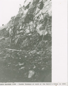
Photograph, Powder monkey at work on Great Ocean Road at Devils Elbow near Eastern View 1920
Photo showing Powder Monkey working at Devil's Elbow near Eastern Viewg.o.r., devil's elbow, eastern view, powder monkey -
 Eltham District Historical Society Inc
Photograph, Aerial view of Eltham Shire Office and Eltham Library precinct, 1994, 1994
Colour photograph of oblique aerial view centred on Eltham Shire Offices, 1994eltham shire office, eltham library, main road, eltham, aerial photograph -
 Federation University Historical Collection
Photograph - Colour, Clare Gervasoni, View of Ballarat Towards Mount Warrenheip from the Ballarat School of Mines, 2015, 03/03/2015
View of Ballarat Towards Mount Warrenheip from the Ballarat School of Mines, 2015smb campus, federation university, mount warrenheip -
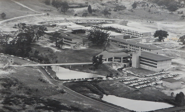 Federation University Historical Collection
Photograph - Photograph - Black and White, Ballarat College of Advanced Education, Aerial view of the Mt Helen campus from the north, c1975
black and white photograph: Aerial view of Mt Helen campus from the north mount helen campus, mount helen campus aerial, student residences, p building, f building, g building, l building, mt helen library, union building, u building, e.j. barker library, aerial -
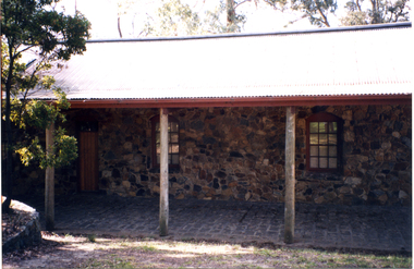 Whitehorse Historical Society Inc.
Photograph, Front View of Museum
Coloured photograph of front view of Museum showing two windows and front door.schwerkolt cottage & museum complex, nunawading & district historical society