Showing 1122 items
matching waterway
-
 Heidelberg Golf Club
Book, Melbourne Parks and Waterways, Lower Plenty River concept plan: Maroondah Pipe Track to Yarra River, 1994
Lower Plenty River concept plan: Maroondah Pipe Track to Yarra River. Includes suggestion of Plenty River Trail along the west boundary of the Heidelberg Golf Club.66 p., illus., colour map. Also, Draft copy of document.plenty river trail, lower plenty river, heidelberg golf club, mmbw, melbourne parks and waterways -
 Lakes Entrance Historical Society
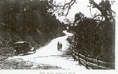
Photograph - Princes Highway Lakes Entrance, 1920c
Black and white photograph of the newly formed Princes Highway. It shows the steep cutting into the Jemmys Point hill, the winding road, the post and rail fence, two people and car of the era on road. Lakes Entrance VictoriaNew Road Jemmy's Pointtopography, waterways, roads and streets, fences -
 Lakes Entrance Historical Society
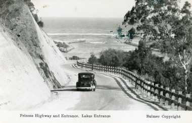
Postcard - The Entrance, Bulmer H D, 1930c
Black and copy 9 x 13.5, has inscription 'Princes Highway and Entrance, Lakes Entrance', ink spill on photo top right hand areaTinted small format postcard of the Princes Highway winding around Jemmys Point, between the steep road cutting and post and rail fence, entrance to Gippsland Lakes in the distance. Lakes Entrance Victoria waterways, roads and streets, vehicles -
 Lakes Entrance Historical Society
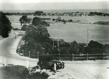
Photograph - Princes Highway Lakes Entrance, 1930c
Black and white photograph of the Princes Highway as it winds around Jemmys Point. It shows a car parked in foreground, person on bicycle riding up hill, lake, Bullock Island and the township in distance. Lakes Entrance Victoria transport, roads and streets, waterways, township -
 Lakes Entrance Historical Society
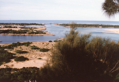
Photograph - The Entrance, 1995c
Second colour copy as 01601-1 portrait size 15 x 10Colour photograph of the entrance from Bass Strait to the Gippsland Lakes. It shows buildings on Bullock Island including Peck's factory. Western end of Bullock Island and area below Jemmys Point, both made during dredging operations over many years. Two fishing boats in entrance. Lakes Entrance Victoria room display, waterways, topography -
 Lakes Entrance Historical Society
Photograph, 2008
Date made August 2008Colour photograph showing eastern end of Rigby Island, Snake Island, Reeves Channel in the foreground, Hopetoun Channel with a house and jetty with boats moored. Ocean in the background. Lakes Entrance Victoriawaterways, islands, vegetation -
 Lakes Entrance Historical Society
Photograph, 1900c
This photograph has been archivedBlack and white photograph of the township, showing the township along Esplanade, Cunninghame Arm taken from the signal station at New Works. A very clear view of rear of Boole Poole School, later used as office, Pilot's residence and Harbour Engineer's residence, Carpenter's residence, and wooden boardwalk. Lakes Entrance Victoriawaterways, topography -
 Lakes Entrance Historical Society
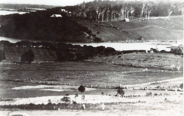
Photograph - Butcher's Paddock, 1935c
Copied from postcard in possession of Mrs Vera BennettBlack and white photograph of cleared land on each side of the North Arm, showing white ring barked trees in front of dense bush on western side, cleared and fenced paddocks on eastern side. Lakes Entrance VictoriaPanorama scene at Seaview Tearooms - Lakes Entrancetownship, waterways -
 Lakes Entrance Historical Society
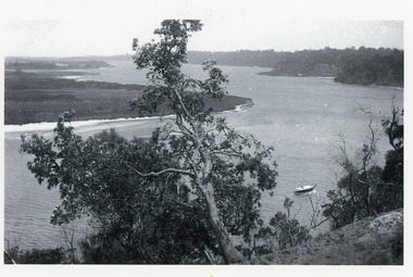
Photograph - Reeves Channel, 1915c
Original in possession of descendant of Arthur Seagrove, teacher at Johnsonville School 1920c.Black and white photograph of Reeves Channel, Gippsland Lakes, showing a launch in the Narrows below Jemmys Point, Rigby Island and a distant view of Fraser Island and Flannagan Island opposite the steep cliffs of the mainland shore. Lakes Entrance Victoria'To Rit with love from Arthur' on backislands, waterways, topography -
 Lakes Entrance Historical Society
Photograph - Cowrie Bay, 1980c
Skipper John Britton, Scott Hobson?, thought to be in mud in Tamar River, Tasm 2011Colour photograph of fishing boat Cowrie Bay which appears to be just outside Cunninghame Arm, the western side of the entrance and hummocks in background. Lakes Entrance Victoriafishing industry, ships and shipping, waterways -
 Lakes Entrance Historical Society
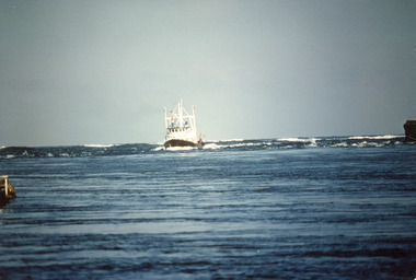
Photograph - James Merlin, Fraser, Ian, 1989c
Colour photograph of the fishing vessel James Kerlin entering the lake from Bass Strait. On right of image is the end of western pier, behind James Kerlin surf is breaking on bar, in foreground calm entrance channel. Lakes Entrance Victoriafishing industry, ships and shipping, waterways -
 Lakes Entrance Historical Society
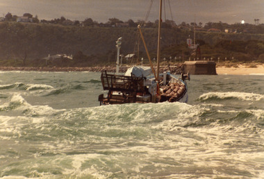
Photograph - Scallop Boat, 1980c
May be 'Lady Jane'Colour photograph of an unidentified scallop fishing boat approaching the entrance channel after crossing the bar. Boat has bags of scallops stacked neatly on deck. Photograph taken from boat following. Lakes Entrance Victoriafishing industry, ships and shipping, waterways, ocean -
 Lakes Entrance Historical Society
Photograph - Posidon, 1975c
Colour photograph of the scallop fishing boat Posidon in Cunninghame Arm. Identified by registration number U7L. Later painted black with white trim. Scrub covered hummocks in background. Lakes Entrance Victoriafishing industry, ships and shipping, waterways -
 Lakes Entrance Historical Society
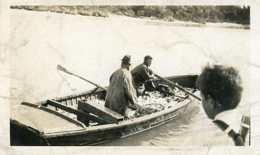
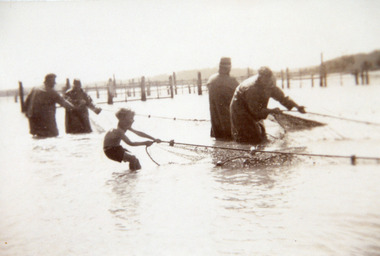
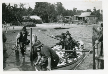
Photograph - Fishing Industry, 1945 c
Black and white photograph of a small motor boat towing a fishing boat containing four men hauling a fishnet full of fish in the entrance channel, Lakes Entrance, Victoria.Bringing full fishnets into fishpens (on reverse of original)fishing industry, boats and boating, fish, waterways -
 Lakes Entrance Historical Society
Photograph - Fishing Industry, 1940 c
Black and white photograph of fishing boat half full of fish being rowed away from unseen jetty, head and shoulders of young boy on right of image. Lakes Entrance Victoriafishing industry, boats and boating, fish, waterways -
 Lakes Entrance Historical Society
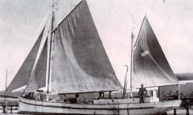
Photograph - Topsy, 1935 c
Black and white photograph of the fishing ketch Topsy with all sails up, jetty in background, at Lakes Entrance, Victoria.fishing industry, fish, occupation, waterways -
 Lakes Entrance Historical Society
Photograph - Fish Pens
Black and white photograph of fishermen working at the fish pens, showing four men and boy hauling full nets into pens. Lakes Entrance Victoriafishing industry, fish, waterways -
 Lakes Entrance Historical Society
Photograph - Crescent, 1905 c
Note in album from Reg Schulz. Ketch 'Crescent' built at Eden NSW about 1905. After a long lay up she was bought by David Coote, Lakes Entrance, about 1925.Black and white photograph showing ketch Crescent at Mallacoota Inlet. Howe Range in background. Nine men onboard. Mallacoota VictoriaGeo. Coleman 1905fishing industry, ships and shipping, waterways -
 Lakes Entrance Historical Society
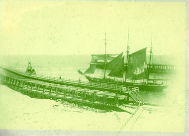
Photograph - Frank Guy, 1891
Frank Guy took timber and piles from Gippsland to Melbourne for wharf constructionSepia photograph of the masted barquentine Frank Guy with sails up being towed out the entrance by the S S Stormbird. Timber entrance piers quite distinct. Lakes Entrance Victoriawaterways, historic ships, piers -
 Lakes Entrance Historical Society
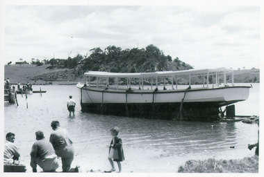
Photograph, Bulmer Studio, 1955
Black and white photography of unknown launch ready for launching. Colin Campbell standing in the water.waterways, boats and boating, tourism -
 Lakes Entrance Historical Society
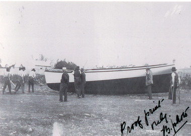
PHotograph, Bulmer Studio, 1955
Black and white photography of unknown launch ready for launching.waterways, boats and boating, launching -
 Lakes Entrance Historical Society
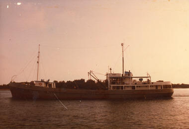
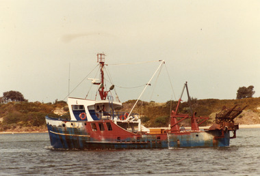
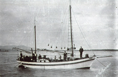
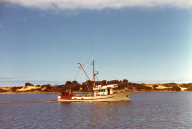
Photograph - William Rose, 1978
Date made March 1978Colour photograph of the fishing boat William Rose in Cunninghame Arm, with sand hummocks in background. Lakes Entrance Victoriafishing industry, waterways, ships and shipping -
 Lakes Entrance Historical Society
Photograph, 1947c
Also black and white enlargement 11.5 x 16Black and white small format photograph of fishermen at the fish pens in lake at Western Side of entrance. Four men in rowing boat loaded with fish, one man on fence, another holding rope to steady boat. Fishermen's cottages in background. Lakes Entrance Victoriafishing industry, boats and boating, waterways, occupation, fish -
 Lakes Entrance Historical Society
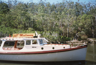
Photograph - Mulloway, Holding M, 1997
Date made January 1997Colour photograph showing charter boat Mulloway MB544, owned by Antony Heath, taken in North Arm. Thick vegetation on far bank. Lakes Entrance Victoriawaterways, boats and boating, tourism -
 Lakes Entrance Historical Society
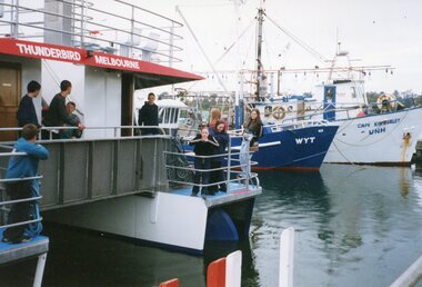
Photograph - Thunderbird, 2000
Date made 9 September 2000Colour photograph showing people on board Peels ferry, Thunderbird, at jetty during weight tests. Two other fishing boats in background. Lakes Entrance Victoria waterways, boats and boating, tourism -
 Lakes Entrance Historical Society
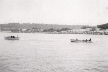
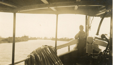
Photograph, 1930c
Sepia photograph taken from a boat on Mitchell River. Appears to be one of the ferries travelling between Bairnsdale and Lakes Entrance. Boy on bow of boat. Victoriawaterways, boats and boating, tourism, transport -
 Lakes Entrance Historical Society
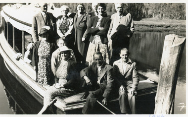
Photograph, 1946
Date made January 1946Black and white photograph of eleven people standing and sitting on the stern of a launch moored in the North Arm, Lakes Entrance, Victoria.boats and boating, waterways, tourism -
 Lakes Entrance Historical Society
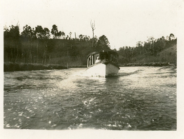
Photograph, 1935c
Black and white small format photograph of an unidentified white hulled launch moving down North Arm, Lakes Entrance, Victoria.waterways, boats and boating, tourism -
 Lakes Entrance Historical Society
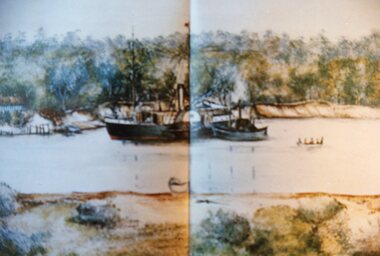
Photograph - Flora Minter, Fish Marie, 2000 c
Colour photograph of copy of Flora Minters painting of the PS Murray in Cunninghame Arm, 1860s/1870s. Below Merrangbaur Hill near old natural entrance to the lakes. Tug boat beside it, and row boat with people. Cottage on bank far left. Photographed from a book. Lakes Entrance Victoriaships and shipping, waterways, vegetation, painting, artist -
 Lakes Entrance Historical Society
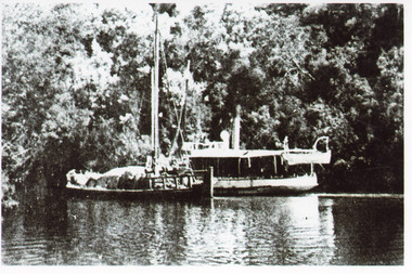
Photograph - S. S. Lady Harriet, 1908
1 x Black and white photograph copied from a book 9.5 x 14.5.Black and white photograph showing S S Lady Harriet at the cliffs on the Tambo river. The Lady Harriet barge on left of S S Harriet, well vegetated cliff behind the vessels. Swan Reach Victoria1908 S S Lady Harriet at cliffs in Tambo River and her barge (on back)jetties, ships and shipping, waterways, topography