Showing 2842 items
matching wests road
-
 Flagstaff Hill Maritime Museum and Village
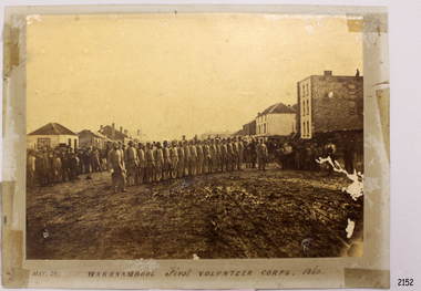
Photograph - Military group, Warrnambool First Volunteer Corps 1860, Taken May 24th, 1860, presented to Mayor in 1887
This Photograph is one of a number of photographs of the Warrnambool Militia. The photograph entitled "Warrnambool First Volunteer Corps" is dated 24th May 1860. (The First Volunteer Corps began in 1855.) It was presented by James Astley Bromfield (former Mayor of Warrnambool) to Major Walter Helpmann, head of Warrnambool’s 1st Volunteer Corps in 1887. The photograph shows the Corps lined up for inspection in Timor Street, Warrnambool. The location is outside what is now the Archie Graham Centre and the camera is looking west towards Liebig Street. The town band is in the right rear corner and spectators surround the Corps. The names listed on the back of the photograph are "1. R.Bushe (Captain in command), 2. Basil Spence, 3. Thomas Mickle, 4. Alfred Davies (Sergeant), 5. Cawthray, 6. Andrew Kerr, 7. Charles Scoborio, 8. Lacy, 9. James Hider, 10. D. O’Mullane, 11. William Norman, 12. Crouthers (or Cowthers ?), 13. Francis Breckon, 14. Russ, 15. Benjamin Wycherley, 16. C. A. Cramer (Sergeant), 17. James Coulstock, 18. Robert Newton (Sergeant), 19. J.A. Bromfield, 20. Singleton (supernumery), 21. Mostyn (Drill Instructor)," On the left of the picture is Billy Adams, Barnes (road contractor) and James Mason (Bootmaker). On the right of the picture is The Band. This is one of a collection of photographs showing the development of the Warrnambool Militia from its inception as the First Volunteer Corps in 1855. The collection is of local significance as it parallels the development of the town and includes images of significant local people. A number of Warrnambool streets are named after members of the Militia. It is also historically significant because of its connection to the unrest that was taking place in Europe at this time. Photograph of Warrnambool First Volunteer Corps 1860, sepia coloured, mounted on cream card. The photograph shows the Corps lined up for inspection in Timor Street Warrnambool. The location is outside what is now the Archie Graham Centre and the camera is looking west towards Liebig Street. The town band is in the right rear corner and spectators surround the Corps. Photograph taken 24th May 1860. Has names listed on reverse side. The protograph was presented to Mayor Helpman, by Bromfield, May 1887. Title printed below base of photo on the mounting board "May. 24. WARRNAMBOOL First VOLUNTEER CORPS. 1860" On the back of the photograph is a numbered list of names, handwritten in ink. Also on the back are presentation details "Presented to Mayor Helpman, by Bromfield, May 1887". warrnambool, wolunteer corps, militia, helpmann, bromfield, flagstaff hill, shipwrecked coast, flagstaff hill maritime museum, maritime museum, shipwreck coast, flagstaff hill maritime village, great ocean road -
 Flagstaff Hill Maritime Museum and Village
Photograph
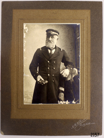
The S.S. Casino was a passenger and freight steamer built in Dundee, Scotland, in 1882 for the Newcastle and Hunter River Steam Navigation Company of N.S.W. She weighed 425 tons gross with a length of 160.4 feet, beam of 24.1 feet and depth of 10.2 feet. She had saloon accommodation for 35 people, forecabin for 25 more people, and she carried 300 tons of cargo. While on her delivery journey on May 30th 1882 the S.S. Casino called in at the Port of Warrnambool for coal ., narrowly escaping going ashore in gale force winds due to the quick action of the pilot. At that time, still at anchor, she impressed the directors of the Belfast and Koroit Steam Navigation Company so much that they bought her immediately; she was ideal for trade in along the West Coast of Victoria. (The Belfast and Koroit Steam Navigation Company was first managed by Messers. Saltau and Osburne and after the passing of Mr. Osburne, by produce merchants Messers H. Sautau and Sons, whose had a hay and corn store and shipping agency was on the corner of Liebig and Koroit Streets in Warrnambool. ) The S.S. Casino became “the most famous steamer to operate in Victorian waters along the West Coast” by author Jack Loney. Captain Boyd was her first Master, followed by Captain Chapman, who stayed with her 1890 until 1924. Captain W. Robertson followed for a short term, then Captain Middleton then took command 1925 - 1932. The S.S. Casino had several mishaps during her life. One was on 3rd January 1898 when she collided with the S.S. Flinders in Apollo Bay with minor damage. Another was on 24th October 1924 when she grounded on a reef at Point Hawdon near Grey River and most of her cargo (of Christmas goods) had to be dumped into the sea. Then in February 1929 she was ‘holed’ when she struck a submerged object as she entered Lady Bay, Warrnambool. On the morning of 10th July 1932, after attempting to berth at Apollo Bay jetty in heavy seas, Captain Middleton decided to take her out into the bay and wait until the seas abated. It was not realised that the anchor used to steady her as she manoeuvred to her berth had pierced her hull. She put about and headed for the beach but sank. Captain Middleton and nine others lost their lives; nine people were rescued including the two female passengers . Captain Middleton had been in charge of the S.S. Casino for seven years. He was the first ship’s Master to lose his life through shipwreck in the West Coast trade. In the years following the turn of the century the S.S. Casino remained the only regular trader with normal passenger accommodation along the West Coast. From 1882 she had made at least 2,500 voyages on the one run. Flagstaff Hill’s collection has a photograph of a portrait of Captain Chapman, , a ship model of the S.S. Casino that shows both forms of power under which she sailed, steam and sail. The ship is painted green and flies three flags. The inscription across the case of the ship model, incorrectly dated, tells the sad story of the wreck of the ship and the loss of lives on July 10th 1932 at Apollo Bay. A print in the Collection show S.S. Casino underway in the heavy sea off Point Lonsdale, another two photographs show her at the Port of Warrnambool, leaving from the Breakwater in Lady Bay and another identifies the S.S. Casino as a ship from the Belfast and Koroit Steam Navigation Company. (Belfast is the original name for the township of Port Fairy).This photograph of Captain Capman is significant because of its association with the coastal trader S.S. Casino and its significance to trade along Victoria's West Coast in the late 19th and early 20th century. The wreck of the S.S. Casino is considered an important part of Victorian and Australian cultural heritage and as such has been declared and protected as an Historic Shipwreck under State and Commonwealth Law in the Commonwealth Historic Shipwrecks Act (1976). Photograph of Captain Chapman of the "S.S.Casino", mounted on card board. flagstaff hill, warrnambool, shipwrecked coast, flagstaff hill maritime museum, maritime museum, shipwreck coast, flagstaff hill maritime village, great ocean road, newcastle and hunter river steam navigation company, belfast and koroit steam navigation company, h. sautau and sons, s.s. casino, west coast trader s.s. casino, victorian coastal trader, captain boyd, captain w. robertson, captain chapman, captain middleton, apollo bay shipwreck, s.s. casino at lady bay warrnambool, saltau and osburne -
 Flagstaff Hill Maritime Museum and Village
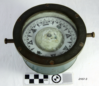
Compass, c. 1930s
The nautical compass is used for determining directions, using a free moving magnetised needle, indicating north and south. This is a medium sized compass and was suitable for mounting in a fixed brass binnacle or a portable wooden box. The compass fluid was typically lamp oil, or a mixture of alcohol and water. This compass, based on its pattern, was probably manufactured around the 1930s. The compass’s maker, Bergen Nautik, was a 20th Century compass manufacturer, making compasses from the 1900s but no longer in business.The factory was located in Hordaland County, Bergen, on the west coast of Norway. This compass is not a very significant marine item as it was made in the 20th century. Examples of the same compass that have been salvaged can be purchased today mounted either in a wooden box or a brass pedestal.Compass; marine or ship's compass, brass, gimbal mounting, in blue metal casing. Manufacturer’s inscription is on the face. Made by Bergen Nautik of Bergen in Norway. Circa 1930s."BERGEN . NAUTIK", "BERGEN", "NORWAY" flagstaff hill, warrnambool, shipwrecked coast, flagstaff hill maritime museum, maritime museum, shipwreck coast, flagstaff hill maritime village, great ocean road, compass, nautical compass, marine compass, maritime compass, technical instrument, navigation instrument, bergen nautik, 20th-century marine compass, gimbal compass, ship's compass, bergan nautik, norway, 1930s marine compass -
 Flagstaff Hill Maritime Museum and Village
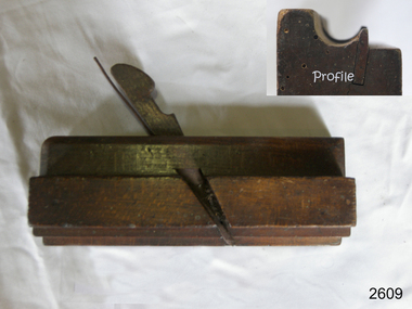
Tool - Wood moulding plane, John Partridge, 1815-1851
Not much is known of John Partridge other than he operated his business of making wood planes and other edged woodworking tools in Birmingham. The Birmingham General Directory of the borough of Birmingham businesses of 1849 has him listed as a "Plane/iron maker" however he was probably making planes from around 1815. Birth and death records indicate he was born in 1797 in West Bromwich, Staffordshire England and that he died in 1851. His wife Sarah Nee Ashton he married at Harborne Staffordshire in 1822 and she also died in 1851, it appears they were survived by three children, John born 1826, Sarah 1835, and William 1838. John Partridge tools are now collector's items and represent a time in history when tools of all kinds were predominately still being made by hand in small family workshops. This was during a time known as the first industrial revolution, a time that was regarded as a transition period in history to new manufacturing processes that were occurring in Europe and the United States. A period of industrial change that began about 1760 and lasted until sometime between 1820 to 1840.Moulding plane Side Bead - Single Box type. Partridge maker stamped on end.flagstaff hill, warrnambool, shipwrecked-coast, flagstaff-hill, flagstaff-hill-maritime-museum, maritime-museum, shipwreck-coast, flagstaff-hill-maritime-village -
 Ringwood and District Historical Society
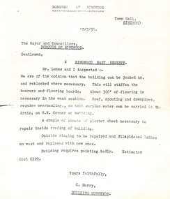
Administrative record - Borough of Ringwood 17/7/51 report to Mayor and Councillors, Document from C Merry, Building Surveyor Ringwood East Reserve
Building report Ringwood East Reserve from C Merry, Building Surveyor and Mr Lucas to the Mayor and Councillors Borough of Ringwood 17/7/51. Building can be jacked up and reblocked where necessary. 300' of flooring is necessary in the west section. Roof, spouting and downpipes require overhauling. Needs some repair work inside and outside. Estimated cost 220 pounds. -
 Ringwood and District Historical Society
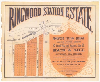
Poster - Auction, Ringwood Station Estate, Ringwood, Victoria - circa 1925
Colour photocopy of poster sub-titled Ringwood Station Reserve & Railway Station Reserve. Auction of 93 sites on Saturday 27th October (no year, likely 1925). Subdivision includes Station Street, Government Road (Wantirna Road), James Street, William Street. Auctioneers - Hair & Gill, 16 Collins Street West and Glenferrie. Solicitor - Seymour Fergie, Elizabeth Street. Surveyors - Fowler & Gatward, 12 Collins Street West. -
 Ringwood and District Historical Society
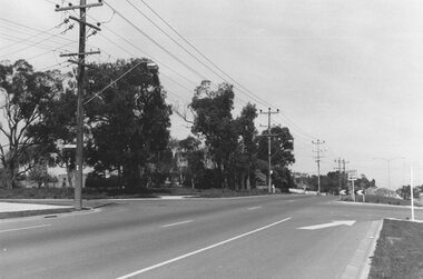
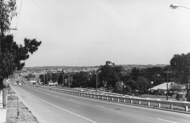
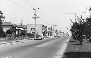
Photograph, Maroondah Highway East, Ringwood- 1969. Looking west towards Ringwood from Everard Road
Black and white photographWritten on back of photograph: "Site of Cass's school, 1874. (1 acre left out of 5 acres). -
 Ringwood and District Historical Society
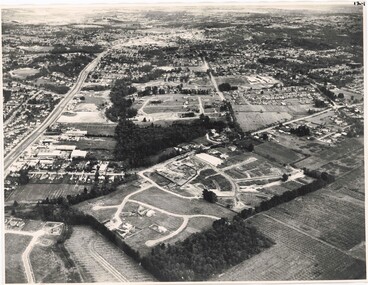
Photograph, Aerial View of Ringwood, Victoria - circa 1970
Black & white west-facing view over Oban Road along Mullum Mullum Road and Creek. Foreground showing early subdivision development of "Dunn's Orchard Estate" with formation of Frederic Drive (named after the orchardist - Frederic Dunn), Baron Court, Towerhill Drive, Tyson Court, Adele Court, Marilyn Crescent, Abbey Court, Highland Boulevard, Ailsa Court. -
 Ringwood and District Historical Society
Photograph, Maroondah Highway East, Ringwood- 1969. Looking west towards Ringwood from Civic Centre
Black and white photographWritten on back of photograph: "Ringwood from Civic Centre." -
 Ringwood and District Historical Society
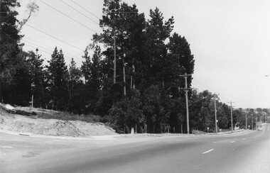
Photograph, Maroondah Highway East, Ringwood- 1969. Looking west towards Ringwood from Braeside Ave corner
Black and white photographWritten on back of photograph: "Nov 1969, cnr of Braeside Ave and Maroondah Highway." -
 Ringwood and District Historical Society
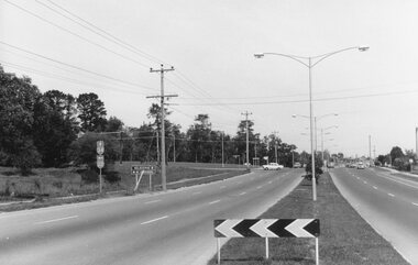
Photograph, Maroondah Highway East, Ringwood- 1969. Looking west towards Ringwood from Mt Dandenong Road intersection
Black and white photographWritten on back of photograph: "Nov 1969, Cnr Mt Dandenong Road and Maroondah Highway." -
 Ringwood and District Historical Society
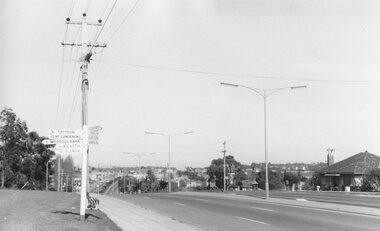
Photograph, Maroondah Highway East, Ringwood- 1969. Looking west towards Ringwood from Mt Dandenong Road
Black and white photographWritten on back of photograph: "Cnr Maroondah Highway and Mt Dandenong Road. Nov 1969." -
 Ringwood and District Historical Society
Photograph, Maroondah Highway East, Ringwood- 1969. Looking west towards Ringwood up from Ringwood Lake
Black and white photographImage shows Ringwood Mail Office on south side of Highway. -
 Ringwood and District Historical Society
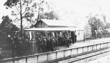
Photograph, Opening Heathmont Railway Station in May 1926, 1926
Opening Heathmont Railway Station in May 1926. The photo shows the audience, including Bill Everard MLA, at the entrance to the railway platform. The Station building was located on the west side of the tracks, near the corner of Heathmont and Canterbury Roads. At the officially opening, the ribbon was cut by Louise Pump, wife of Herman. -
 Ringwood and District Historical Society
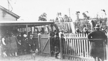
Photograph, Opening Heathmont Railway Station in May 1926, 1926
Opening Heathmont Railway Station in May 1926. The photo shows the audience, including Bill Everard MLA, just behind the gate at the entrance to the railway platform. The Station building was located on the west side of the tracks, near the corner of Heathmont and Canterbury Roads. At the officially opening, the ribbon was cut by Louise Pump, wife of Herman. -
 Ringwood and District Historical Society
Map - Public Land Sale by Thomas Ham, 2000 Acres for Sale - Crown Sections 20, 23, 24 - Ringwood, Victoria - 1855
Two 1850s surveyor's maps on cardboard backing showing area from Melbourne extending East beyond Bulleen and Nunawading. Detailed description of lots for sale and navigational directions to the property from Richmond by Thomas Ham, Victorian public servant, map maker, publisher, lithographer and original Ringwood land owner. Inset map enlarging area between Yarra River and Dandenong Creek, with southern boundary of allotments later forming part of Oban Road, North Ringwood.TRANSCRIPT: "This really valuable Property is now offered to the public for sale, in lots to suit purchasers at the Iow rate of £1 per Acre for 80 acres and upwards, and £1.10s per Acre for any smaller portion. Terms of payment Half Cash, Balance in 6 and 12 months, bearing 8 per cent interest. The Estate is well wooded with Gum, Cherry Tree and Stringy Bark, with Wattle in the valleys of the several creeks. Every lot is Staked and Trenched at the corners marked on the Plan thus - The Surveyor has carefully sub-divided the Property, in order to give every Farm a Creek for Water, Valley for Cultivation, and Hills for House and Grass Paddock. The ROADS have been very carefully laid out so as to give a firm, well drained, and nearly level road to each Homestead. Intending purchasers can readily find the property by the following directions, viz: Start from Richmond Bridge, at Hawthorne, then take the left-hand road to KEW. When at the "Woodman Inn", take the Cotham Road to the right, bearing due east, keep this Road, passing Trainor's "White Horse" Inn, and before you leave the fences, you will see calico bills (see margin) nailed to the Trees on the bush track leading to the Upper Yarra country, follow the Bills till you come to the SOUTH boundary line of the Property, which bears East and West (see Plan) where you will see Bills nailed up "THIS PROPERTY FOR SALE, etc." The Bills from Town lead direct to where Mr. Jull is erecting his Store, and arrangements have been made with him to show the lots to intending purchasers free of charge. At the respective corners of the lots the Bills are nailed up double, with numbers to denote the lot, and that the corner stake is adjacent. Any parties wishing to proceed to the property by way of BULLEEN will find Bills nailed on the Trees, commencing at the NEW INN, at "Wilson's Slip Rail." Keep this Track till you come to the Log Bridge, over the Deep Creek at Bloxhome's Paddock; go through the land now being cleared; keep the track over the hill till you come to an Iron House, you will then be on the property, which Iies to the North and East as per Plan. Follow the Bills till you come to Mr. Jull's Store, etc. etc. Further particulars can be had from the Agent for the Property. THOMAS HAM. " -
 Ringwood and District Historical Society
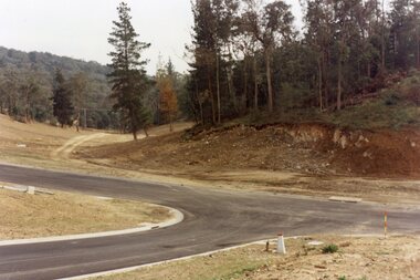
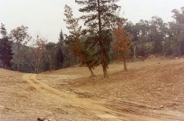
Photograph, Kubis Estate, North Ringwood in April 1978. Looking west across Kubis and Werac Drives over the full length of Loughnan's Lake site. Main pool was behind the lone pine
E548 N29 Part of a 51-photo record of the development of the "Kubis" Estate, Ringwood North, including road works to Debbie Place, Kubis Drive, Werac Drive, Manuelo Drive, Iluka Place and Glenvale Road. From the Jack Lundy Clarke collection. -
 Ringwood and District Historical Society
Photograph, Kubis Estate, North Ringwood in April 1978. Looking west over site of Loughnan's Lake. The rope tree was on the slope to the right beyond the ridge with the lone pine
E548 N15 Part of a 51-photo record of the development of the "Kubis" Estate, Ringwood North, including road works to Debbie Place, Kubis Drive, Werac Drive, Manuelo Drive, Iluka Place and Glenvale Road. From the Jack Lundy Clarke collection. -
 Ringwood and District Historical Society
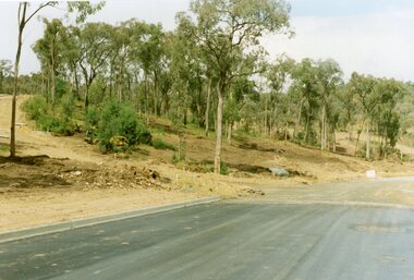
Photograph, Corner of Pamela Court and Kubis Drive, North Ringwood, looking west on 3rd November 1978
E551 N15 Part of a 51-photo record of the development of the "Kubis" Estate, Ringwood North, including road works to Debbie Place, Kubis Drive, Werac Drive, Manuelo Drive, Iluka Place and Glenvale Road. From the Jack Lundy Clarke collection. -
 Ringwood and District Historical Society
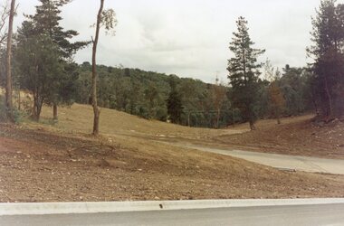
Photograph, Looking west across Werac and Kubis Drives, North Ringwood, in April 1978. Loughnan's Lake site. The retaining wall was where the truck tracks disappear over thhe ridge. The spillway was at that spot
E548 N3 Part of a 51-photo record of the development of the "Kubis" Estate, Ringwood North, including road works to Debbie Place, Kubis Drive, Werac Drive, Manuelo Drive, Iluka Place and Glenvale Road. From the Jack Lundy Clarke collection. -
 Ringwood and District Historical Society
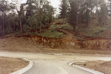
Photograph, Looking from Werac Drive, North Ringwood, on 14th April 1978, across the site of the headwaters of Loughnan's Lake. Main body of water lay to the left (west)
E548 N7 Part of a 51-photo record of the development of the "Kubis" Estate, Ringwood North, including road works to Debbie Place, Kubis Drive, Werac Drive, Manuelo Drive, Iluka Place and Glenvale Road. From the Jack Lundy Clarke collection.51 -
 Ringwood and District Historical Society
Photograph, Looking west from Kubis Drive, North Ringwood, in April 1978, over the full length of the site of Loughnan's Lake
E548 N5 Part of a 51-photo record of the development of the "Kubis" Estate, Ringwood North, including road works to Debbie Place, Kubis Drive, Werac Drive, Manuelo Drive, Iluka Place and Glenvale Road. From the Jack Lundy Clarke collection.51 -
 Ringwood and District Historical Society
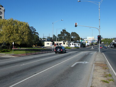
Photograph, Maroondah Highway, looking west, at the coner of Wantirna Road,in 2008. Showing the Clocktower and Haymes Paint (south-west corner)
Photographic record by Russ Haines, RDHS, in 2008. -
 Ringwood and District Historical Society
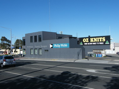
Photograph, 135 Maroondah Highway, looking south-west across Ringwood Street intersection, in 2008. Showing Philip Webb real estate, formerly the SEC
Photographic record by Russ Haines, RDHS, in 2008. -
 Ringwood and District Historical Society
Photograph, North west shops in Melbourne Street, Ringwood in 2008, at the corner of Maroondah Highway. Showing the Activate Church and Burdines
Photographic record by Russ Haines, RDHS, in 2008. -
 Ringwood and District Historical Society
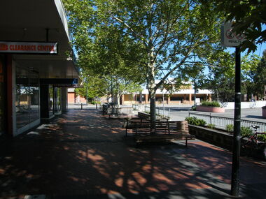
Photograph, Looking west towards Ringwood Street, in Civic Place, Ringwood in 2008, near to Midway Arcade. Showing JB Clearance Centre and Post Office across the road
Photographic record by Russ Haines, RDHS, in 2008. -
 Ringwood and District Historical Society
Photograph, West side of Melbourne Street, Ringwood in 2008
Photographic record by Russ Haines, RDHS, in 2008. -
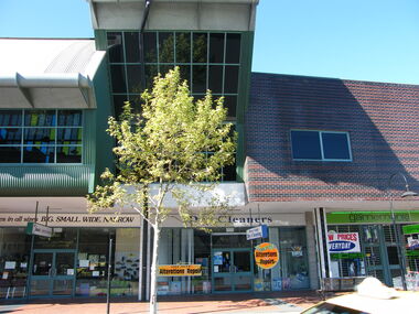
 Ringwood and District Historical Society
Photograph, West side of Melbourne Street, Ringwood in 2008, with various businesses
Photographic record by Russ Haines, RDHS, in 2008. -
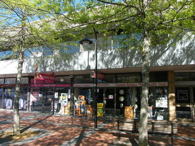
 Ringwood and District Historical Society
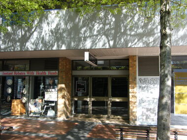
Photograph, West of entrance to Eastland, Ringwood in 2008, showing shops at Ringwood Plaza and Ringwood Library above
Photographic record by Russ Haines, RDHS, in 2008. -
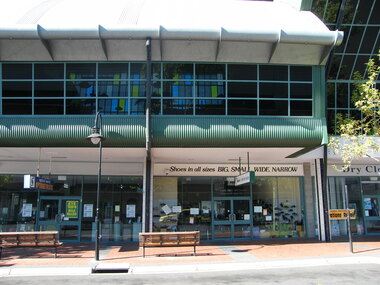
 Ringwood and District Historical Society
Photograph, West of entrance to Eastland, Ringwood in 2008, showing shops at Ringwood Plaza and Ringwood Library above
Photographic record by Russ Haines, RDHS, in 2008.