Showing 8816 items matching "lake"
-
 Lakes Entrance Historical Society
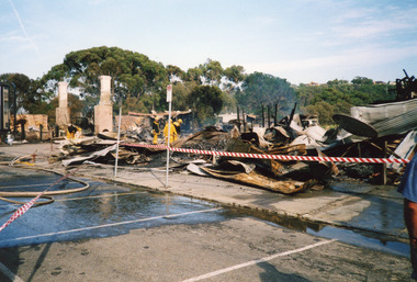
Photograph - Club Hotel Fire, 2000
Date made December 2000Colour photograph showing destroyed Club Hotel. Photo taken from the Esplanade, front carparks covered with water and hoses as Lakes Entrance Fire Brigade damp down remaining trouble spots. Lakes Entrance Victoriahotels, fire brigade, disasters -
 Lakes Entrance Historical Society
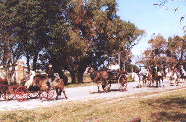
Photograph - Lakes Alive Festival, Purch, Roadknight Street Lakes Entrance Victoria, 1/09/1975 12:00:00 AM
Colour photograph of Pony Club entries in Lakes Alive festival street parade at the Eastern end of Roadknight Street Lakes Entrance Victoria. Also a second colour photograph taken from similar position at same event recreation, festival, events -
 Lakes Entrance Historical Society
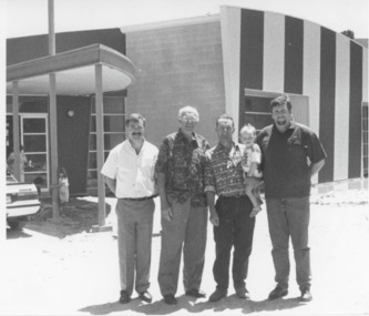
Photograph - Aquatic Centre, Lakes Post Newspaper, 1995
number in album 03527.01Black and white photograph winners of the Name the Pool competition Roger Horsley, Tony McKean who both suggested Lakes Aquadome with Centre Manager Noel Boyes and Shire Commissioner Bruce Evans. Lakes Entrance Victoriarecreational facilities, competitions -
 Lakes Entrance Historical Society
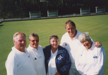
Photograph - Bowls, Lakes Post Newspaper, 2000
Colour photograph Lakes Entrance Bowls Club team winners of Metung Invitation Mixed Fours, Lester Gudgin, Audrey Fulford, Ern Peachey, Pam Moran, Metung President John Lewis. Lakes Entrance Victoriabowls club, sports -
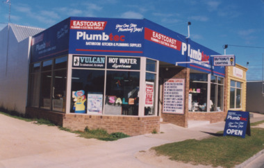 Lakes Entrance Historical Society
Photograph - Eastcoast Plumbtec, 1995
Colour photograph of Paul Rooster Marsden and five other staff members taken at opening of Eastcoast Plumbtec, Church Street Lakes Entrance Victoria also colour photograph of Plumbtec shop in Church St Lakes Entrance businesses, plumbing, people -
 The Beechworth Burke Museum
Photograph, 1960s
This photograph was taken in the 1960s at Lake Sambell Caravan Park and visible in the photograph are individual caravan sites with electricity outlets, a large single-story building with a caravan park banner, dirt roads, a freestanding message board, and a parked car. Lake Sambell Caravan Park opened in 1959 owing to the work of R.E. Carter, Beechworth Shire engineer from 1954-63. Carter advocated for improvements to the lake and surrounding area in order to encourage tourism in Beechworth. The opening of the caravan park was part of many improvements to Lake Sambell made in this period by Carter including: the swimming pool in 1961, water skiing and boating facilities, and increased lake surface in 1964. These improvements were financed mainly by grants from the Tourist Development Authority. The popularity of caravanning in Australia exploded during this post-war period of the late 1950s and 1960s. This popularity was driven by multiple factors, including: the stopping of fuel rations, the accessibility of car ownership through the manufacturing of affordable cars, technological developments in caravan design, and the increase in prosperity and leisure time for many Australians. Facilities such as electrical outlets to power caravans are present in this photograph of Lake Sambell Caravan Park. Lake Sambell is an artificial lake that was developed on the previous site of the Rocky Mountain Mining Company workings and was officially opened by Minister for Lands, Mr Baily, on October 5, 1928. The disused and unattractive remains of the mine were converted into a recreational area intended for swimming, boating, and fishing. The lake is named after Mr L.H. Sambell, shire engineer and secretary of the Forward Beechworth Committee, who advocated for the enhancement of Beechworth into a tourist destination and was central to the planning and establishment of the lake. This photograph is of historical and social significance in providing insight into caravanning during the 1960s in Australia. Caravanning was extremely popular during the 1960s in Australia due to multiple social and economic factors including the stopping of fuel rations, the accessibility of car ownership through the manufacturing of affordable cars, technological developments in caravan design, and the increase in prosperity and leisure time for many Australians.Black and white rectangle photograph printed on photographic paper and unmounted.Reverse: 3536/ [logo back printing: KODAK/ VELOX/ PAPER] / C798 lake sambell caravan park, lake sambell, caravanning 1960s, caravan park, rocky mountain mining company, kodak velox paper, r.e. carter, l.h. sambell, caravan electricity outlets, tourist development authority, post-war prosperity, forward beechworth committee, lake sambell boating, lake sambell swimming pool, lake sambell fishing, artificial lake, travel 1960s, recreation 1960s -
 The Beechworth Burke Museum
Photograph, 1960s
This photograph was taken in the 1960s at Lake Sambell Caravan Park, visible in the photograph are individual caravan sites with electricity outlets, a large single-story building, a parked car, and two caravans partially obstructed by trees. Lake Sambell Caravan Park opened in 1959 owing to the work of R.E. Carter, Beechworth Shire engineer from 1954-63. Carter advocated for improvements to the lake and surrounding area in order to encourage tourism in Beechworth. The opening of the caravan park was part of many improvements to Lake Sambell made in this period by Carter including: the swimming pool in 1961, water skiing and boating facilities, and increased lake surface in 1964. These improvements were financed mainly by grants from the Tourist Development Authority. The popularity of caravanning in Australia exploded during this post-war period of the late 1950s and 1960s. This popularity was driven by multiple factors, including: the stopping of fuel rations, the accessibility of car ownership through the manufacturing of affordable cars, technological developments in caravan design, and the increase in prosperity and leisure time for many Australians. Facilities such as electrical outlets to power caravans are present in this photograph of Lake Sambell Caravan Park. Lake Sambell is an artificial lake that was developed on the previous site of the Rocky Mountain Mining Company workings and was officially opened by Minister for Lands, Mr Baily, on October 5, 1928. The disused and unattractive remains of the mine were converted into a recreational area intended for swimming, boating, and fishing. The lake is named after Mr L.H. Sambell, shire engineer and secretary of the Forward Beechworth Committee, who advocated for the enhancement of Beechworth into a tourist destination and was central to the planning and establishment of the lake. This photograph is of historic and social significance in documenting the enhancement of the Lake Sambell area overseen by R.E. Carter and providing insight into caravanning during the 1960s in Australia. Caravanning was extremely popular in Australia during the late 1950s and 60s due to multiple social and economic factors including the stopping of fuel rations, the accessibility of car ownership through the manufacturing of affordable cars, technological developments in caravan design, and the increase in prosperity and leisure time for many Australians. Black and white rectangle photograph printed on photographic paper and unmounted.Reverse: 3538/ [logo back printing KODAK/ VELOX/ PAPER] / C798lake sambell caravan park, lake sambell, lake sambell 1960s, lake sambell fishing, lake sambell boating, lake sambell swimming pool, r.e. carter, l.h. sambell, tourist development authority, caravanning 1960s, caravan electricity outlets, caravan park, forward beechworth committee, rocky mountain mining company, lake caravan park, caravan mid 20th century, beechworth tourism, travel in the 1960s, holiday 1960s -
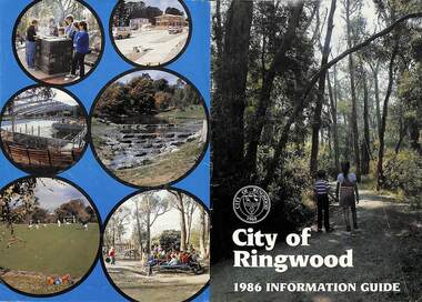 Ringwood and District Historical Society
Booklet, City of Ringwood 1986 Information Guide, 1986
Community information booklet issued by City of Ringwood for 1986 - covering the facilities and activities of the Ringwood Council and other local organisations and associations. Cover photographs: Front - Wombalano Park; Back L-R - Barbecue at Ringwood Lake, Housing construction at Ringwood, Enclosing swimming centre, Water cascade at rear of Ringwood Lake, Croquet at Jubilee Park, Playground at Ringwood Lake.CONTENTS: (page no.) After School Care Programme 30 & 31 Amalgamations 16 Aquatic Centre 14 & 15 Building Information 22 By-Law and Traffic Regulations 23 Chief Executive Message I0 Churches 38 Civic Centre 4 Committees of Council 5 Community Plan 12 & 13 Construction Work 34 Council Meeting Dates 4 Council Representatives 8 Councillors 6 & 7 Disabled Persons Facilities 41 Eastern Corridor Road Action Plan 17 Emergency Telephone Nos. 63 European Wasps 27 Family Day Care 30 Finances 18 Golf Course 22 Health 20 Historical Research Group 44 Home Help 33 Hospitals 45 Immunisations 2 i Incinerators 34 Infant Welfare Centres 45 Knaith Road Child Care Centre 30&31 Library 24 Local Area Traffic Management 17 Management Executive 11 Mayoral Message – Cr. W.R. (Bill) Wilkins, J.P. 3 Meals on Wheels 32 Members of Parliament 9 North Ringwood Senior Citizens 29 Parks for People 28 Playgroups 49 Pre-Schools 50 Rates 19 Rubbish — See Waste Ringwood District Centre 16 Schools 52 Swimming Pool — See Aquatic Centre 14 & 15 Waste 26rinx -
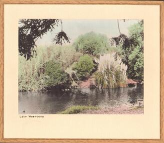 Bendigo Historical Society Inc.
Photograph - LAKE WEEROONA
Hand tinted photograph of Lake Weeroona. Bamboo, flax, pampas grass, trees, family of ducks in water. Inscriptions: on back - in grey lead pencil 'Lake Weeroona', On mount - printed BLS at front - 'Lake Weeroona'. History: with note 'photographs from Mrs Ella Bourke, 131 Barnard St, Bendigo, ph 438269'. :Photographs Francis (Frank) Thomas Kennedy'.Francil (Frank) Thomas Kennedyplace, public gardens, lake weeroona, see also 2001.152.01, 2001.153.01, 2001.154.01, 2001.157.01, 2001.158.01, 2001.159.01, 2001.161.01, 2001.162.01 -
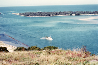 Lakes Entrance Historical Society
Photograph - The Entrance, Fraser, Ian, 1990c
Colour photograph of the lake. It shows a fishing boat with scallop dredge moving up the lake opposite the artificial entrance, grassy edge of Jemmy's Point in foreground above highway guard fence, rock groyne at entry to North Arm, sandy shallows at entry to Hopetoun Channel, scrub covered hummocks of south shore and Bass Strait in distance. Lakes Entrance Victoriaislands, waterways, topography -
 Lakes Entrance Historical Society
Album, LERHS members, Honour Boards from East Gippsland Victoria, 2010
Photographs of Honour Boards from around Gippsland. Includes Bruthen, Omeo, Glen Valley, Lakes Entrance, Kalimna, Swan Reach, Tambo Upper, Lake Tyers Rd School, Briagalong, Swifts Creek, TarravilleA small album containing photographs of Honour Boards from East Gippsland Victoria. Please visit L.E. History Centre to view all photos. schools, ww1, ww2, memorials -
 The Beechworth Burke Museum
Photograph, 1960s
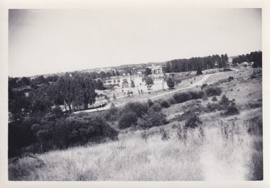
This photo was taken in the 1960s from a northeast position looking down towards Lake Sambell, the caravan park, and the surrounding area. This photo was taken during a period of rejuvenation for the lake area including the opening of the caravan park in 1959 and the swimming pool area in 1961 (this pool is just visible in the centre of the photo). The popularity of caravanning in Australia exploded during this post-war period of the late 1950s and 1960’s. This popularity was driven by multiple factors, including: the stopping of fuel rations, the accessibility of car ownership through the manufacturing of affordable cars, technological developments in caravan design, and the increase in prosperity and leisure time for many Australians. Lake Sambell is an artificial lake that was developed on the previous site of the Rocky Mountain Mining Company workings and was officially opened by Minister for Lands, Mr Baily, on October 5, 1928. The disused and unattractive remains of the mine were converted into a recreational area intended for swimming, boating, and fishing. The lake is named after Mr L.H. Sambell, shire engineer and secretary of the Forward Beechworth Committee, who advocated for the enhancement of Beechworth into a tourist destination and was central to the planning and establishment of the lake. Funding for the project was raised by both competition funds and donations. Since the construction in 1928 several engineering issues have arisen. In 1939 the water levels were low, and the lake was considered both an eyesore and ‘mudhole’, Beechworth Shire Council sort funding to raise the height of the lake six feet to improve the quality of water. Throughout the 1940s the Beechworth Swimming Club tried to raise awareness and funds to address the structural engineering issues and improve swimming facilities at the lake. R.E. Carter, similar to L.H. Sambell, was a shire engineer who advocated the importance of positioning Beechworth as a tourist destination. Carter held the position from 1954-63 and organised many improvements to the Lake Sambell area including the caravan park in 1959, the lake swimming pool in 1961, water skiing and boating facilities, and increased the lake surface are in 1964. These improvements were financed mainly by grants from the Tourist Development Authority. This photograph is of historical significance as it documents Lake Sambell and the surrounding area in the 1960s after a phase of enhancements to improve the appearance and usability for both the people of Beechworth and tourists. It is also of social significance in providing an insight into the increase in leisure time and access to travel during a period of post-war prosperity.Black and white rectangle photograph printed on matte photographic paper and unmounted.Reverse: 1 / [logo KODAK/ VELOX/ PAPER] / C798 / 3535lake sambell, lake sambell caravan park, lake sambell swimming pool, caravan park, caravanning 1960s, rocky mountain mining company, l.h. sambell, r.e. carter, beechworth swimming club, forward beechworth committee, minister of lands, tourist development authority, lake swimming, swimming, boating, fishing, water skiing, beechworth 1960s, lake sambell fishing, lake sambell boating -
 The Beechworth Burke Museum
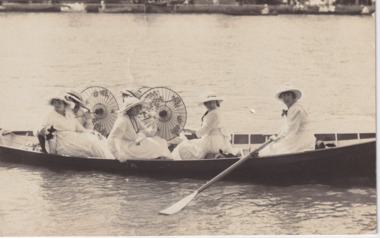
Postcard, 1900s
Photographed in the 1900s, the postcard depicts six young women seated in a canoe. They are all wearing white dresses, and three of them are holding Japanese umbrellas.Black and white rectangular postcard printed on card.Reverse: 3710 / POST CARD / KODAK / 29 / 3710 / CORRESPONDENCE / | / ADDRESS ONLY / AUSTRAL / 15 / AUSTRAL / KODAK /entertainment album, 1900s, canoe, lake, postcard, japan, japanese umbrellas, white dresses -
 Ballarat Heritage Services
Photograph - digital photographs, Lisa Gervasoni, Marysville Pre Olympic Swimming Pool, c2010-2017
Colour photograph of a natural swimming pool at Marysville. swimming pool, sport, swimming, pre olympic, marysville, lake, marysville swimming pool, marysville swimming hole -
 Ballarat Heritage Services
digital photographs, Lisa Gervasoni, Yarrawonga Pre Olympic Swimming Pool, c2010-2017
Colour photograph of the Yarrawonga Pre Olympic Swimming Pool in the Murray River. swimming pool, sport, swimming, pre olympic, natural, lake, yarrawonga, murray river -
 Ballarat Heritage Services
Photograph - digital photographs, Lisa Gervasoni, Coburg pre olympic swimming pool, c2010-2017
Colour photograph of the Coburg pre olympic swimming poolswimming pool, sport, swimming, pre olympic, natural, lake, coburg, coburg swimming pool -
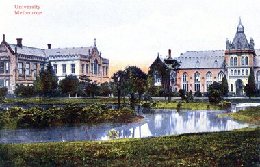 Greensborough Historical Society
Postcard, University Melbourne, 1900c
Early photograph of University of Melbourne grounds, with lake.Colourised photograph printed on one side, correspondence and address sections on reverse"printed in Germany 155/146062"university of melbourne, melbourne -
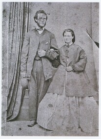 Lake Bolac & District Historical Society
Black and white photograph, Josiah and Mary Park
Josiah and Mary Park, (1867) of Lake Bolac. -
 Malmsbury Historical Society
Photograph (Item), B/W A Group Of People In The Gardens, Malmsbury ca1930
People - "Spencer, P" Buildings - Malmsbury Lake -
 Whitehorse Historical Society Inc.
Photograph, Original site of Pannam's Store, C.1983
Donor developed Educational Programme at Blackburn Lake.Black and white photo of original site of Pannam's Store, Corner Boronia and Canterbury Roads, Vermont.pannam's store, pannam, charles., meagher, dorothy -
 Whitehorse Historical Society Inc.
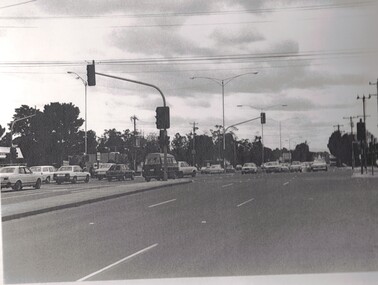
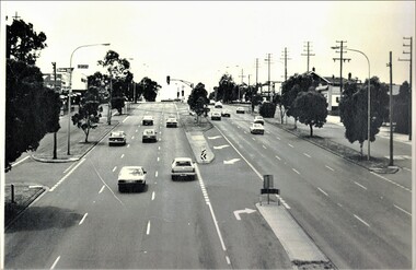
Photograph, Springvale Road looking South, 1/09/1983 12:00:00 AM
Donor developed Educational Programme at Blackburn Lake.Black and white photo of Springvale Road looking South. Intersects with Whitehorse Road, Nunawading.meagher, dorothy, springvale road, nunawading, whitehorse road, nunawading -
 Whitehorse Historical Society Inc.
Photograph, Vermont State School,1983, 1983
Donor developed Educational Programme at Blackburn Lake.Black and white photo of Vermont State School, 1983.meagher, dorothy, vermont state school, no. 1022 -
 Whitehorse Historical Society Inc.
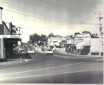
Photograph, Blackburn Road, 1983
Donor developed Educational Programme at Blackburn Lake.Laser Print of black and white photo of Blackburn Road looking South over Blackburn Railway Gates.blackburn railway crossing, meagher, dorothy -
 Whitehorse Historical Society Inc.
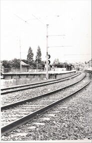
Photograph, Blackburn Railway Station, 1984
Donor developed Educational Programme at Blackburn Lake.Laser Print of black and white photo of Blackburn Railway Station.meagher, dorothy, blackburn railway station -
 Whitehorse Historical Society Inc.
Photograph, Corner Whitehorse & Springvale Roads, 1983
Donor developed Educational Programme for Blackburn Lake.Laser Print of black and white photo of Corner Whitehorse and Springvale Roads Nunawading, looking North. (2 copies) (Mounted)meagher, dorothy -
 Whitehorse Historical Society Inc.
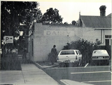
Photograph, Old Dairy at Blackburn, 1983
Donor developed Educational Programme for Blackburn Lake.Laser Print of black and white photo of Old Dairy at Blackburn - Corner Railway Road and Albert Street. (Mounted)meagher, dorothy, railway road, blackburn, albert street, blackburn -
 Whitehorse Historical Society Inc.
Photograph, Whitehorse Road, 1983
Donor developed Educational Programme for Blackburn Lake.Laser Print of black and white photo of Whitehorse Road, Mitcham, looking East 1983. (Mounted)meagher, dorothy, whitehorse road, mitcham -
 Whitehorse Historical Society Inc.
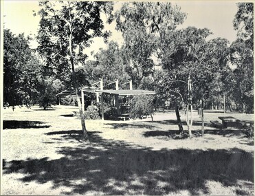
Photograph, Picnic Area at Antonio Park, 1983
Donor developed Educational Programme for Blackburn LakeLaser print of black and white photo of Picnic Area at Antonio Park, corner Deep Creek Road and Whitehorse Road , Mitcham. 1977. (Mounted)meagher, dorothy, antonio park, mitcham, deep creek road, mitcham, whitehorse road, mitcham -
 Whitehorse Historical Society Inc.
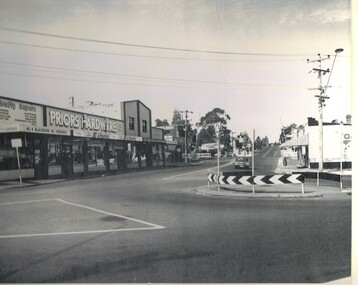
Photograph, Roundabout, 1983
Donor developed Educational Programme for Blackburn LakeLaser Print of black and white photo of Roundabout, corner Blackburn and Railway Roads, Blackburn. (Mounted)meagher, dorothy, blackburn road, blackburn, railway road, blackburn -
 Ballarat Heritage Services
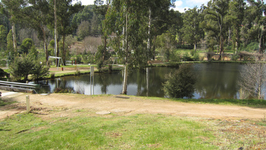
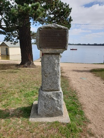
Photograph - Boathouse, Clare Gervasoni, Cairn displaying the place were William Cross Yuille Camped, 2021
Lake Wendouree was originally known as Yuille's Swamp.Colour photograph of a cairn displaying the place were William Cross Yuille CampedNear this spot was the camp of the first resident of Ballarat William Cross Yuille in March 1938. Presented by Cr A.J. Darling. Mayor of Ballarat 1034. Ballt Historical Socylake wendouree, william cross yuille, a.j. darling, yuille's swamp, marker