Showing 8862 items matching "lake "
-
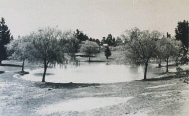
 Malmsbury Historical Society
Photograph (Item), Malmsbury Gardens, Malmsbury ca1990
Buildings - "Gardens,Lake,War Memorial" -
 City of Ballarat Libraries
Postcard - Card Box Photographs, Eureka Reserve, Ballarat circa 1900
Located on Stawell Street. View of the lake.eureka reserve, stawell street, garden, public, eureka gardens -
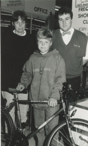
 Lakes Entrance Historical Society
Photograph, Lakes Post Newspaper, Foodarama Lakes Entrance, 1/05/1994 12:00:00 AM
winners of competition Lakes Entrance VictoriaBlack and white photograph showing Danny Sannos Grocery Manager of Arceris IGA Supermarket with Gill and Stephen Ely businesses, competitions -
 Lakes Entrance Historical Society
Photograph, Lakes Post Newspaper, Foodarama Lakes Entrance, 1/05/1994 12:00:00 AM
Competition winners Lakes Entrance VictoriaBlack and white photograph showing Danny Sannos Grocery Manager of Arceris IGA Supermarket with Jenny and David Bowen businesses, competitions -
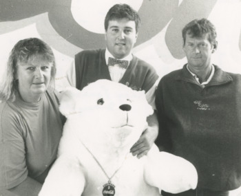
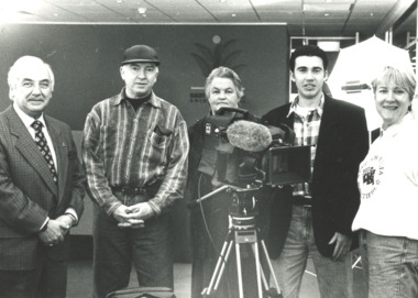 Lakes Entrance Historical Society
Photograph, Keep Australia Beautiful Council, Lakes Entrance, 1996
Making a documentary about Lakes EntranceBlack and white photo of Peter Wood, East Gippsland Shire; Margaret Daly and Anne Canterbury, Keep Australia Beautiful Council; Fred Fargher and Andrew Ross, film maker and camera man; . Plus another photo taken at Nyerimilang Park includes Trevor McCubbin, Margaret Daly, Cr Frank Hunter with Bill Cane, Tidy Town Judgemedia, film -
 Lakes Entrance Historical Society
Photograph, Deputy Premier John Thwaite opening Cunninghame Circuit Lakes Entrance, Victoria, 25.5.2001
Opening of Cunninghame Circuit Lakes Entrance Colour photograph of Deputy Premier John Thwaites. Plus three other photos of same event waterways, tourism, topography -
 Lakes Entrance Historical Society
Photograph, Charlie and Keith Carpenter Lakes Entrance Victoria, 1927 c
taken on bridge Lakes Entrance VictoriaBlack and white photograph of Charlie and Keith Carpenter with girl cousin Dolly. Also a second black and white photograph of Charlie and Keith Carpenter with a cousin c1927genealogy, fashion -
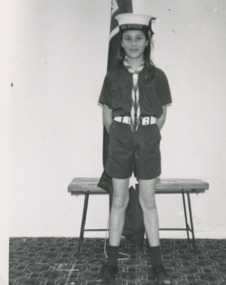 Lakes Entrance Historical Society
Photograph, Lakes Post Newspaper, Kirsty Turner
Kirsty Turner Lakes Entrance VictoriaBlack and white photograph of new member of First Sea Scouts B Group sea scouts, clubs -
 The Beechworth Burke Museum
Photograph, 1960s
This photograph was taken in the 1960s at Lake Sambell Caravan Park and visible in the photograph are individual caravan sites with electricity outlets, a large single-story building with a caravan park banner, dirt roads, a freestanding message board, and a parked car. Lake Sambell Caravan Park opened in 1959 owing to the work of R.E. Carter, Beechworth Shire engineer from 1954-63. Carter advocated for improvements to the lake and surrounding area in order to encourage tourism in Beechworth. The opening of the caravan park was part of many improvements to Lake Sambell made in this period by Carter including: the swimming pool in 1961, water skiing and boating facilities, and increased lake surface in 1964. These improvements were financed mainly by grants from the Tourist Development Authority. The popularity of caravanning in Australia exploded during this post-war period of the late 1950s and 1960s. This popularity was driven by multiple factors, including: the stopping of fuel rations, the accessibility of car ownership through the manufacturing of affordable cars, technological developments in caravan design, and the increase in prosperity and leisure time for many Australians. Facilities such as electrical outlets to power caravans are present in this photograph of Lake Sambell Caravan Park. Lake Sambell is an artificial lake that was developed on the previous site of the Rocky Mountain Mining Company workings and was officially opened by Minister for Lands, Mr Baily, on October 5, 1928. The disused and unattractive remains of the mine were converted into a recreational area intended for swimming, boating, and fishing. The lake is named after Mr L.H. Sambell, shire engineer and secretary of the Forward Beechworth Committee, who advocated for the enhancement of Beechworth into a tourist destination and was central to the planning and establishment of the lake. This photograph is of historical and social significance in providing insight into caravanning during the 1960s in Australia. Caravanning was extremely popular during the 1960s in Australia due to multiple social and economic factors including the stopping of fuel rations, the accessibility of car ownership through the manufacturing of affordable cars, technological developments in caravan design, and the increase in prosperity and leisure time for many Australians.Black and white rectangle photograph printed on photographic paper and unmounted.Reverse: 3536/ [logo back printing: KODAK/ VELOX/ PAPER] / C798 lake sambell caravan park, lake sambell, caravanning 1960s, caravan park, rocky mountain mining company, kodak velox paper, r.e. carter, l.h. sambell, caravan electricity outlets, tourist development authority, post-war prosperity, forward beechworth committee, lake sambell boating, lake sambell swimming pool, lake sambell fishing, artificial lake, travel 1960s, recreation 1960s -
 The Beechworth Burke Museum
Photograph, 1960s
This photograph was taken in the 1960s at Lake Sambell Caravan Park, visible in the photograph are individual caravan sites with electricity outlets, a large single-story building, a parked car, and two caravans partially obstructed by trees. Lake Sambell Caravan Park opened in 1959 owing to the work of R.E. Carter, Beechworth Shire engineer from 1954-63. Carter advocated for improvements to the lake and surrounding area in order to encourage tourism in Beechworth. The opening of the caravan park was part of many improvements to Lake Sambell made in this period by Carter including: the swimming pool in 1961, water skiing and boating facilities, and increased lake surface in 1964. These improvements were financed mainly by grants from the Tourist Development Authority. The popularity of caravanning in Australia exploded during this post-war period of the late 1950s and 1960s. This popularity was driven by multiple factors, including: the stopping of fuel rations, the accessibility of car ownership through the manufacturing of affordable cars, technological developments in caravan design, and the increase in prosperity and leisure time for many Australians. Facilities such as electrical outlets to power caravans are present in this photograph of Lake Sambell Caravan Park. Lake Sambell is an artificial lake that was developed on the previous site of the Rocky Mountain Mining Company workings and was officially opened by Minister for Lands, Mr Baily, on October 5, 1928. The disused and unattractive remains of the mine were converted into a recreational area intended for swimming, boating, and fishing. The lake is named after Mr L.H. Sambell, shire engineer and secretary of the Forward Beechworth Committee, who advocated for the enhancement of Beechworth into a tourist destination and was central to the planning and establishment of the lake. This photograph is of historic and social significance in documenting the enhancement of the Lake Sambell area overseen by R.E. Carter and providing insight into caravanning during the 1960s in Australia. Caravanning was extremely popular in Australia during the late 1950s and 60s due to multiple social and economic factors including the stopping of fuel rations, the accessibility of car ownership through the manufacturing of affordable cars, technological developments in caravan design, and the increase in prosperity and leisure time for many Australians. Black and white rectangle photograph printed on photographic paper and unmounted.Reverse: 3538/ [logo back printing KODAK/ VELOX/ PAPER] / C798lake sambell caravan park, lake sambell, lake sambell 1960s, lake sambell fishing, lake sambell boating, lake sambell swimming pool, r.e. carter, l.h. sambell, tourist development authority, caravanning 1960s, caravan electricity outlets, caravan park, forward beechworth committee, rocky mountain mining company, lake caravan park, caravan mid 20th century, beechworth tourism, travel in the 1960s, holiday 1960s -
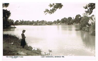 Bendigo Historical Society Inc.
Postcard - LAKE WEEROONA, BENDIGO
Postcard, black and white. Image shows woman standing on LH side on shore of lake. Ducks in water and on bank. Island partly visible on RH side. On bottom ' The Rose Series P 2854, Lake Weeroona, Bendigo, Vic'Rose Series/Rose Stereograph Co., Armadale, Victoriabendigo, parks and gardens, lake weeroona, bendigo, lake weeroona, boat sheds -
 Bendigo Historical Society Inc.
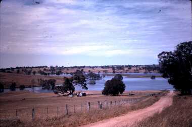
Slide - DAVID MCDONALD COLLECTION: EPPALOCK. CONSTRUCTION, c1962
Eppalock. Construction. The lake is now filling, the fence line and the road disappear down into the lake. Near the water there is a ''Road Closed sign''. To the left of the road there are two old sheds. Markings: Eppalock Dam, Dec 1962 near Lyal.Kodakcivil engineering, water supply, eppalock -
Whitehorse Historical Society Inc.
Article, Keeping us all 'postered', 1990
Winners of the Nunawading Rotary Club's school poster competition will be announced at a family fun day at Blackburn Lake.Winners of the Nunawading Rotary Club's school poster competition will be announced at a family fun day at Blackburn Lake. Part of the club's major fund raising campaign to raise $50,000 to help extend the information and display centre at Blackburn Lake.Winners of the Nunawading Rotary Club's school poster competition will be announced at a family fun day at Blackburn Lake. nunawading rotary club, blackburn lake, blackburn technical school, dibattista, mario, eaton, paul, forster, peter -
 Lakes Entrance Historical Society
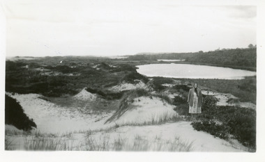
Photograph, 1950c
Also enlargement 15x25cmBlack and white photograph of the Warm Holes, from the sand hummocks looking west. The Warm Holes are the remnant of Reeves River, the original waterway from the Gippsland lakes to the natural entrance. Lady with shawl in foreground. Lakes Entrance Victoria waterways, topography -
 Lakes Entrance Historical Society
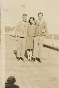
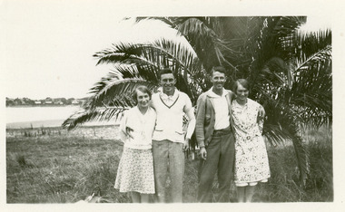
Photograph - Wills/Legg
Black and white photograph of Rita Wills and boyfriend John Alexander with friends Gladys Legg of Lakes Entrance and her boyfriend Keith Scarce taken in front of the young palm tree opposite the Club Hotel Lakes Entrance Victoriaclothing, genealogy -
 Lakes Entrance Historical Society
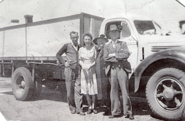
Photograph - Doyle, 1947 c
Black and white photograph of Wally and Marjory neeWarne Doyle of Eden with his parents Alice nee Grant and William Doyle of Bairnsdale previously Lakes Enrtrance, standing beside Hancocks International D45 truck at Lakes Entrance Victoria genealogy, vehicles -
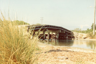 Lakes Entrance Historical Society
Photograph - Bridges, Fish Marie, 1965
Also one other photograph, similar viewColour photograph of the first road bridge from Lakes Entrance to Bullock island, which was built for Public Works Dept. groyne building and sand build up to enlarge the island. Built early 1953. Lakes Entrance Victoria topography, bridges, islands, public works -
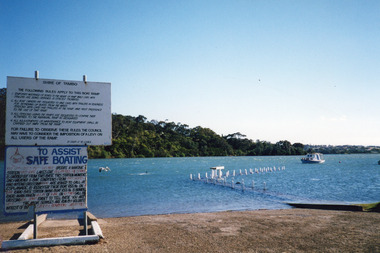 Lakes Entrance Historical Society
Photograph - North Arm Lakes Entrance, Holding M, 2000
Date made January 2000Colour photograph of high tide in the North Arm. It shows the boat ramp and jetty under water, boat moored in lake, pelican fishing nearby. Warning and instruction signs on shore. Kalimna Heights in background. Lakes Entrance Victoriaboats and boating, waterways, safety -
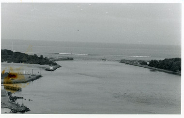
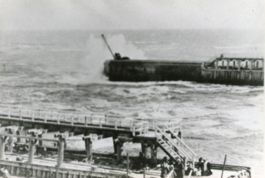 Lakes Entrance Historical Society
Photograph - Western Pier, 1918c
Black and white photograph showing piers and entrance to lakes from ocean Bass Strait. Western pier in back ground shows concrete extension to original wooden pier. Wooden eastern pier in foreground. Lakes Entrance Victoriapiers, waterways -
 Lakes Entrance Historical Society
Postcard - The Entrance, 1940c
2 x identical mini postcards collected 6.5 x 9|1 x photographic print copy 18.5 x 25Black and white small format postcard of the man-made entrance from Bass Strait to the Gippsland Lakes, taken from Jemmys Point. It shows the rock groynes at Bullock Island and North Arm entrance. Lakes Entrance Victoriaislands, waterways, topography -
 Lakes Entrance Historical Society
Photograph - The Entrance, 1986
Black and white photograph of the entrance from Bass Strait to the Gippsland Lakes. It also shows the rock groynes at Bullock Island filled with dredged sand to extend the island. Fishing boat coming through entrance. Lakes Entrance Victoriaislands, topography, waterways -
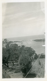 Lakes Entrance Historical Society
Photograph - The Entrance, 1950c
Black and white photograph of the man-made entrance from Bass Strait to the Gippsland Lakes, taken from the lookout tower on Jemmys Point. In foreground is the natural vegetation of Jemmys Point and a glimpse of the light beacon. Lakes Entrance Victoriaislands, waterways -
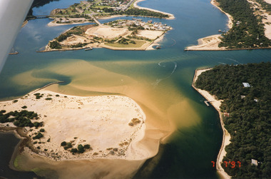 Lakes Entrance Historical Society
Photograph - Lakes Entrance, 1997
Date made 7 July 1997Colour photograph being an aerial view of entrance at Lakes Entrance, showing the sand hummocks, the sand bar offshore a fishing boat entering the channel through the bar which appears to be recently dredged township of Lakes Entrance Victoria waterways, islands, boats and boating -
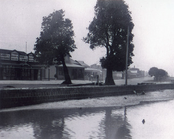 Lakes Entrance Historical Society
Photograph - Post Office, 1923c
Freeman's took over the store after the death of John Barke, December 1921, photo taken before the removal of native trees and planting of Memorial Cypresses in 1924Black and white photograph of Esplanade, showing Freemans, previously Barkes Store, the Post Office, and Postmasters residence, with other buildings in the distance. Two tall trees between road and bluestone wall on the edge of the lake. Lakes Entrance Victoriatownship, waterfront, postal services -
 Lakes Entrance Historical Society
Photograph - Fraser Island, Holding M, 2000c
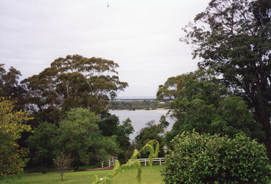
Colour photograph taken from the veranda of Nyerimilang Homestead, Gippsland Lakes. It shows a glimpse of Fraser Island through the trees and ornamental shrubs of the homestead garden. Fence and pathway to viewing platform in centre foreground. Lakes Entrance Victoriaislands, historic site -
 Lakes Entrance Historical Society
Photograph - Carpentertown, Phillips, Miss L, 1900c
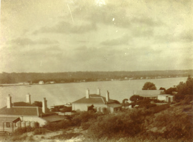
Also black and white copy 9 x 14 cmSepia photograph showing lake, Cunningham Arm, in front of three houses on dunes at New Works. House on left is harbour masters, centre is harbour engineer's house and on right is house of contractor John Carpenter. Lakes Entrance Victoriajetties, waterfront, historic buildings -
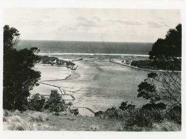
 Lakes Entrance Historical Society
Photograph - Foreshore Lakes Entrance, Bulmer H D, 1923c
Second copyBlack and white photograph showing aerial view of the entrance to the Gippsland Lakes, shows Cunninghame Arm, North Arm, Reeves River and Hopetoun Channel, Rigby Island and Snake Island, the barrier on right foreground. Lakes Entrance Victoriawaterways, islands, aerial photograph, fishing industry, coast -
 Lakes Entrance Historical Society
Photograph - Lakes Entrance State School, 1930 c
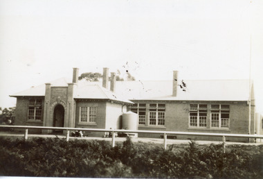
Black and white photograph of Lakes Entrance State School, Myer St., showing a concrete building, four chimneys through the roof, arched entry flanked by pillars with school name and number above arch. Lakes Entrance Victoriaschools, room display, buildings -
 Lakes Entrance Historical Society
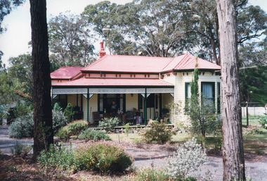
Photograph - Nithsdale, 2000
Original name of dwelling 'Nithsdale' retained by present owners.Colour photograph of a timber dwelling at 357 Lakes Tyers Beach Road, with corrugated iron hipped roof, decorative timber frieze under veranda, bay window on front room, painted heritage colour. Lake Tyers Victoriahouses, architecture -
Lakes Entrance Historical Society
Book, McMahon, David and Fitzclarence, Eunice, Rob the Milkman - Robert Hamilton McMahon, 2009
An edited account of the diary of Robert Hamilton McMahon written 1917-1918, when he served as 'milkman' for the township of Lakes Entrance and associated settlements, from his dairy herd on Rigby Island and the Barrier, Gippsland Lakes, Victoria.township, land settlement