Showing 123958 items matching "main-road"
-
 Greensborough Historical Society
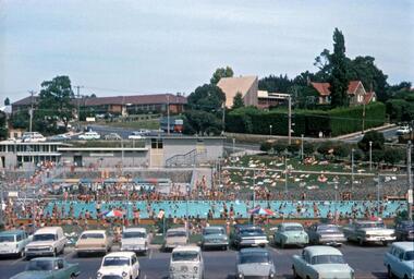
Photograph - Digital Image, R. Max Neumann, Greensborough Main Swimming Pool 1970, 1970_02
Greensborough Swimming Pool, main pool, February 1970.An early photograph of the Pool, now demolished to make way for the Watermarc developmentDigital copy of colour photographgreensborough swimming pool, greensborough pool, watermarc -
 Greensborough Historical Society
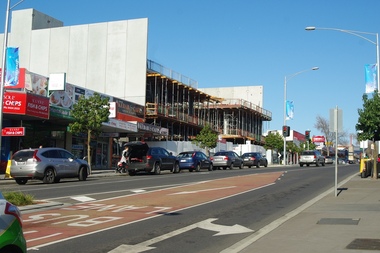
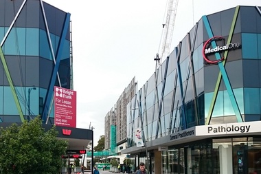
Photograph - Digital image, Marilyn Smith, New construction, Main Street Greensborough, 19/08/2015
New development centred on 78 Main Street Greensborough.Digital copy of colour photographmain street greensborough -
 Federation University Historical Collection
Book, Alex Sideratos et al, Anderson's Mill Smeaton - Main Report. Student Project, 1992
Anderson's Mill Smeaton - Main Report. Student Project.White bound book of 80 pages and includes five appendices.anderson's mill, smeaton, alex sideratos, ozlem soyogul, michael pearlman, jane lennon, chris smith, simon nelly, barry golding, russel dawe, margaret giles, ross squires, executive summary, introduction, methodology, swot analysis, site analysis, concept/product analysis, summary of market research, other development options to consider, community involvement, preferred option & cost analysis, marketing recommendations, management issues, conclusion, the courier ballarat, department of conservation and natural resources, creswick business promotions committee, creswick, daylesford, kingston, allendale, flour mill, anderson brothers, convent gallery daylesford, mill restaurant malmsbury, oat mill -
 Stawell Historical Society Inc
Photograph, Seppelts Main Building & Cellars in Great Western 1969
Seppelts Great Western Main Building & Cellars 1969stawell winery -
 Stawell Historical Society Inc
Photograph, Seppelts Main Entrance Door in Great Western 1969
Seppelts Great Western Main Entrance Door 1969stawell winery -
 Stawell Historical Society Inc
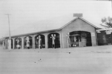
Photograph, Garage with Petrol Bowsers on the Corner Main & Patrick Streets Stawell
Garage - Corner Main & Patrick Streets with Petrol Bowsers.stawell, garages -
 Stawell Historical Society Inc
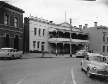
Photograph, Commercial Hotel in Upper Main Street Stawell c1960
Commercial Hotel c1960. Upper Main Street Stawell. stawell businesses -
![Newspaper - Newspaper Clipping - Digital Image, The Valley Voice, [Main Street Greensborough 1978], 08/11/1978](/media/collectors/4f729f5697f83e03086015b8/items/674ab0558f48af8ae71d31f3/item-media/674ab0778f48af8ae71dca42/item-fit-380x285.jpg) Greensborough Historical Society
Greensborough Historical SocietyNewspaper - Newspaper Clipping - Digital Image, The Valley Voice, [Main Street Greensborough 1978], 08/11/1978
Main Street Greensborough 1978 showing the streetscape and trafficDigital copy of newspaper articlegreensborough plaza, main street greensborough -
 Greensborough Historical Society
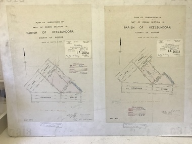
Poster - Planning Document, City of Heidelberg, Subdivision Plan # G313, Corner Main and Grimshaw Streets, Greensborough, 08/03/1960
Plan of Subdivision at corner of Main and Grimshaw Streets, Greensborough.An example of hard copy subdivision plans from the Greensborough area. Mainly from the Shire of Diamond Valley era (1964-1994).Plan (2 sheets) mounted on heavy card.Stamped and handwritten Council permissions, dates and other details.subdivision plans, main street greensborough, grimshaw street greensborough -
 Stawell Historical Society Inc
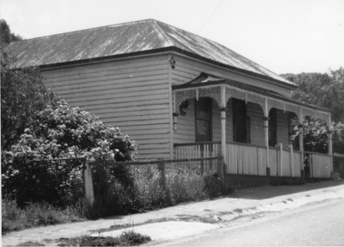
Photograph, Upper Main Street with a Weatherboard Home – Reeve Family
Weatherboard Home Upper Main Street – Reeve Family. Black and white photgrapgh of a weatherboard house with veranda across the front, around which is a wooden fence, with a gateway on the streetstawell, reeve -
 Rutherglen Historical Society
Image, 1890
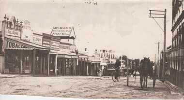
Black and white photograph of Main Street, Rutherglen, looking westOn back of photo: "Main St, Rutherglen 1890"main street, rutherglen -
Whitehorse Historical Society Inc.
Map, Springvale Road, 1987
Aerial photograph of cnr Springvale Road and Burwood Highway, south past Highbury Road and west past Blackburn Road.Aerial photograph of cnr Springvale Road and Burwood Highway, south past Highbury Road and west past Blackburn Road.Aerial photograph of cnr Springvale Road and Burwood Highway, south past Highbury Road and west past Blackburn Road.aerial photographs, blackburn road, burwood east, highbury road, burwood east, burwood highway, burwood east, springvale road, burwood east, burwood east -
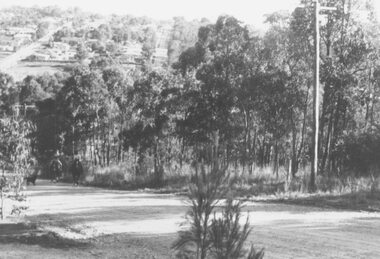
 Whitehorse Historical Society Inc.
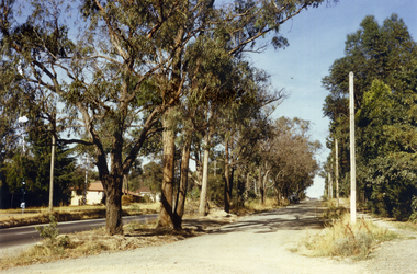
Photograph, Canterbury Road, Vermont, 1967
Part of Tim Shambrook's Collection for 'This is Vermont'. Not used.Coloured photo of Canterbury Road, Vermont, taken in 1967 showing one lane road and heavily treed side road.canterbury road, vermont, shambrook, tim -
 Greensborough Historical Society
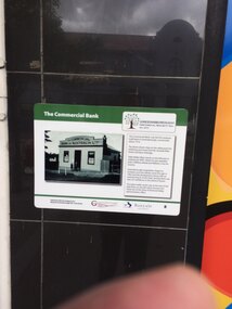
Photograph - Digital Image, Chris Foster, The Commercial Bank Greensborough (Main Street Plaques Project), 17/05/2018
In 2018, Greensborough Historical Society placed plaques in the Main Street area of Greensborough. In these photographs, GHS member Chris Foster, accompanied by GHS President Noel Withers, has photographed the installation of the 'Commercial Bank' plaque on Main Street Greensborough. The Main Street Plaques Project placed historical information about original Greensborough buildings as close to the original site as possible. Further information available on the GHS website. The Plaques were made possible through a Greensborough RSL Grant.Digital copy of 2 colour photographs.main street plaques project, main street greensborough, commercial bank greensborough -
 Greensborough Historical Society
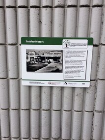
Photograph - Digital Image, Chris Foster, Stubley Motors Greensborough (Main Street Plaques Project), 17/05/2018
In 2018, Greensborough Historical Society placed plaques in the Main Street area of Greensborough. In these photographs, GHS member Chris Foster, accompanied by GHS President Noel Withers, has photographed the installation of the 'Stubley Motors' plaque on Main Street Greensborough. The Main Street Plaques Project placed historical information about original Greensborough buildings as close to the original site as possible. Further information available on the GHS website. The Plaques were made possible through a Greensborough RSL Grant.Digital copy of 2 colour photographs.main street plaques project, main street greensborough, stubley motors -
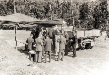 Eltham District Historical Society Inc
Photograph, Country Road Board members having morning tea just south of St Andrews, Heidelberg-Kinglake Road, 1962, 1962
Black and white photograph of Council and Country Road Board group with truckheidelberg kinglake road, kinglake road -
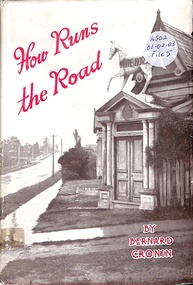 Ringwood and District Historical Society
Book, How Runs the Road
Romance and appeal of roads and a look at the future of Australian roads and transport -
 Glen Eira Historical Society
Photograph, Murrumbeena Road, 229, Murrumbeena, 2001
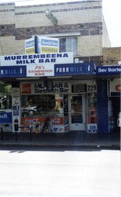
Originally labelled "Beauville Estate, Established 1936, Still Thriving 65 years on, 10th March 2001", the Beauville Estate Album contains colour photographs of houses in the Estate. They were taken around the time of the Beauville Estate’s 65th Heritage Celebration held on 10/03/2001 and donated to the Caulfield Historical Society shortly afterwards. Photographer unknown. From Glen Eira’s Heritage Management Plan by Andrew Ward (1996) Vol 2 p78: In Murrumbeena Road, the shops which form part of the estate are a simple cream brick row relieved by manganese bricks in bands across the upper storeys. City of Glen Eira’s Heritage Management Plan Vol 2 p79 (this is p84 of the pdf version) – HO12 Beauville Estate and environs, Murrumbeena: The Beauville Historic Area is important at the State level as the first large housing estate undertaken by the AV Jennings Construction Co, later Jennings Group Limited, Victoria’s largest home builder. It is important also as a very early estate development incorporating a range of features other than houses and including made roads, shops and recreation facilities. In this respect it was the forerunner of the comprehensively planned housing estate of the post war era. The estate is distinguished by its aesthetic values, as is the earlier and comparable Hillcrest Estate, which are formed by a combination of restrained diversity in house styles, with the exception of no. 30 in the emerging International style, and by a landscaped garden environment. Colour photograph of a section of a double storey, unpainted brick, commercial property containing shops at ground level all with awnings over the footpath. This specific property is a milk bar on street level with plate glass windows and door, colourful advertising and "229' in the top right section of the window. Shop signage says "MURREMBEENA MILK BAR". The upper storey brick residence features a large window, a flat roof and decorative two tone banded brickwork. MURREMBEENA (sic) MILK BAR / PK's / SANDWICH / BAR / MILK BAR & Sandwich Bar / 229 / SUB NEWSmurrumbeena, architectural styles, 1930's, inter war style, a.v. jennings, av jennings, jennings, beauville estate, murrumbeena road, milk bars, commercial establishments, flats, sir albert victor jennings, a v jennings construction co, beauville estate heritage area, glen eira city council, architectural features, jennings group limited, land subdivision, beauville historic area, shops, brick features, window displays, advertising signs, murrembeena (sic) milk bar -
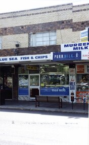 Glen Eira Historical Society
Photograph, Murrumbeena Road, 229A, Murrumbeena, 2001
Originally labelled "Beauville Estate, Established 1936, Still Thriving 65 years on, 10th March 2001", the Beauville Estate Album contains colour photographs of houses in the Estate. They were taken around the time of the Beauville Estate’s 65th Heritage Celebration held on 10/03/2001 and donated to the Caulfield Historical Society shortly afterwards. Photographer unknown. From Glen Eira’s Heritage Management Plan by Andrew Ward (1996) Vol 2 p78: In Murrumbeena Road, the shops which form part of the estate are a simple cream brick row relieved by manganese bricks in bands across the upper storeys.City of Glen Eira’s Heritage Management Plan Vol 2 p79 (this is p84 of the pdf version) – HO12 Beauville Estate and environs, Murrumbeena: The Beauville Historic Area is important at the State level as the first large housing estate undertaken by the AV Jennings Construction Co, later Jennings Group Limited, Victoria’s largest home builder. It is important also as a very early estate development incorporating a range of features other than houses and including made roads, shops and recreation facilities. In this respect it was the forerunner of the comprehensively planned housing estate of the post war era. The estate is distinguished by its aesthetic values, as is the earlier and comparable Hillcrest Estate, which are formed by a combination of restrained diversity in house styles, with the exception of no. 30 in the emerging International style, and by a landscaped garden environment. Colour photograph of a section of a double storey, unpainted brick, commercial property containing shops at ground level all with awnings over the footpath. This specific property is a fish and chip shop. The upper storey brick residence features a curtained window, a flat roof and decorative two tone bands of brickwork. It has a large street seat on the footpath out front.BLUE SEA FISH & CHIPS / TAKE AWAY FOODmurrumbeena, architectural styles, 1930's, inter war style, a.v. jennings, av jennings, jennings, beauville estate, murrumbeena road, milk bars, commercial establishments, flats, fish & chip shops, sir albert victor jennings, a v jennings construction co, beauville estate heritage area, glen eira city council, architectural features, jennings group limited, land subdivision, beauville historic area, brick features, restaurants -
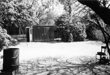 Surrey Hills Historical Society Collection
Digital photo, George L Coop, Back yard of 686 Whitehorse Road, Mont Albert c 1953, c1953
This is a photo of the backyard of the property adjacent to the Coop's home. At the time the neighbours were Mrs Daisy McKernan (a widow) and her son Alexander Colin McKernan. The clothes line prop was a forerunner of the clothes hoist. Clothes line props were standard purchase items at many local hardware stores and the donor poetically described them as holding "long lines of drying washing above the dusty democracy of many a rough back yard." Whilst the Coop home is still extant in 2019 and used as professional rooms for Dr Peter Chau, an eye surgeon, 686 Whitehorse Road has been replaced by units. This captures the utilitarian nature of the 'typical' back yard before the advent of rampant consumerism. Large areas of open lawn were a desirable central feature, often edged with neatly contained garden beds. Better lawnmowers, plus the promotion of new chemicals and fertilisers to help home gardeners grow the perfect lawn. Missing is the rotary hoist and the vegetable garden.A black & white photo on a sunny day of a backyard with the following features: a timber shed, an additional shed / hen house, a hand lawn mower leaning against a tree, several hens and a metal drum (perhaps used as bonfire container). A sloping pole/prop may be seen on the left. backyards, (mrs) daisy mckernan, alexander colin mckernan -
Glenelg Shire Council Cultural Collection
Photograph - Photograph - Main Breakwater construction, Portland, n.d
Port of Portland Authority ArchivesBack: Main Breakwater - pencilport of portland archives, main breakwater, construction, portland, harbour, harbour development -
 Ringwood and District Historical Society
Photograph, View of Glenvale Road, Ringwood 1964
See Also #25Written on back of photograph, "1964 - View of Glenvale Road. Supplied by Garrett Gundry. Warnes Road in left background. Deep Creek Road in centre background." -
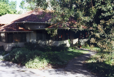 Whitehorse Historical Society Inc.
Photograph, 443 Mitcham Road, Mitcham, 1998
Eric Roger Webb moved to Mitcham with his family in about 1932. They lived at 443 Mitcham Road and owned all the land up to Simpson Street. The land was a grass paddock and he planted native trees and shrubs around the perimeter. The Webbs has three children: Eric, Dean and Donald. Mr Webb worked in the public service. He was a councillor of the Shire of Blackburn and Mitcham and later of the city of Nunawading between 1940 and 1949. He was also a Shire President from 1943-1944.Coloured photograph of a house at 443 Mitcham Road, Mitcham. Tiled roof, verandah, path leading to front door.443 mitcham road, mitcham, houses, webb, eric -
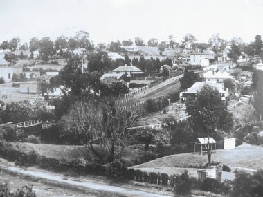
 Greensborough Historical Society
Photograph - Digital Image, Greensborough, looking up Main Street, 1950c
Greensborough in the 1950s, looking towards Main Street from Greenhills.Digital copy of black and white photographmain street greensborough -
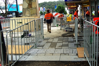 Greensborough Historical Society
Photograph - Digital Image, Marilyn Smith, Main Street Greensborough, installation of new footpath, 24/06/2018
Installation of new footpath on Plaza side of Main Street GreensboroughDigital copy of colour photographmain street greensborough -
 Greensborough Historical Society
Photograph - Digital Image, Lower Main Street Greensborough c1930s, 1930s
A view of lower Main Street Greensborough taken from in the 1930s.Digital copy of black and white photograph.main street greensborough -
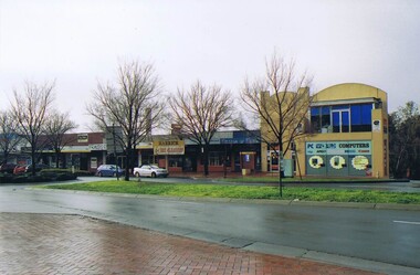 Greensborough Historical Society
Photograph - Digital image, Frank Solomon, Greensborough: Main Street shopping strip at Grimshaw Street end, 04/06/2010
Greensborough: Main Street shopping strip at Grimshaw Street end.Digital copy of colour photographmain street greensborough, grimshaw street greensborough -
 Greensborough Historical Society
Photograph - Digital image, Marilyn Smith, Main Street Medical/Bank building, 19/07/2016
Medical and Bank building, Main Street Greensborough July 2016.Digital copy of colour photographmain street greensborough -
![Newspaper Clipping, Diamond Valley Leader, 85 & 87 Main Street Greensborough [advertisement], 15/06/2016](/media/collectors/4f729f5697f83e03086015b8/items/5923fb98d0ce770eb0e3d5c8/item-media/5923fbfdd0ce770eb0e417ac/item-fit-380x285.jpg) Greensborough Historical Society
Greensborough Historical SocietyNewspaper Clipping, Diamond Valley Leader, 85 & 87 Main Street Greensborough [advertisement], 15/06/2016
Advertisement for auction of two retail premises in Main Street Greensborough.News clipping, black text and colour imagemain street greensborough -
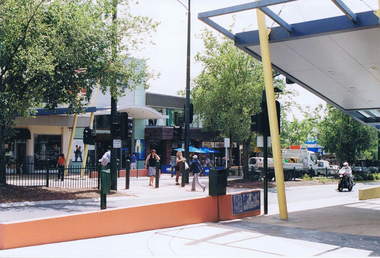 Greensborough Historical Society
Photograph - Digital image, Frank Solomon, Main Street outside Plaza entrance, 04/06/2010
View of Main Street Greensborough outside the entrance to Greensborough Plaza.Digital copy of colour photographmain street greensborough, greensborough plaza