Showing 3609 items
matching street map
-
 Bayside Gallery - Bayside City Council Art & Heritage Collection
Photograph, Department of Crown Lands and Survey, Victoria, Brighton, Brighton East and Bentleigh, c. 1965-71
The Department of Crown Lands and Survey (1857-1983) was responsible for the administration of survey and mapping and the sale, occupation and management of crown land throughout its existence. This aerial photograph shows parts of Brighton and Brighton East and was taken circa 1965-71.brighton, department of crown lands and survey, aerial photograph, bayside, port phillip bay, map, cartographic material, brighton east, dendy park, dendy street, centre road, nepean highway, south road, brighton golf course, golf -
 Bayside Gallery - Bayside City Council Art & Heritage Collection
Map - print, Melbourne and Metropolitan Board of Works, Interim development order: Brighton, Moorabbin and Sandringham, 1959
The Melbourne and Metropolitan Board of Works (now Melbourne Water) was established in 1891. From that time, as part of their work laying water and sewerage connections, they created detailed plans of houses and other buildings in the Melbourne metropolitan area. In 1956 it acquired powers to construct and maintain highways and bridges, protect and improve the foreshores and create and maintain parks within the metropolitan region. This Interim development order comprises part of the municipalities of Brighton, Moorabbin and Sandringham and was made on 20 October 1959.brighton, moorabbin, sandringham, melbourne and metropolitan board of works, map, town planning, cartographic material, interim development order, bayside -
 Bendigo Historical Society Inc.
Booklet - Your Clan Heritage - Clan Macleod, 1989
34-page white cover booklet about the history of the Clan Macleod in Scotland. Clan crest in colour on the front cover also repeated on page 1 with the Macleod Tartan and a water colour of a castle. Repeated again on page 2 with the Lewis Tartan and a water colour of Ardvreck Castle. The crest features a full-on head of a bull. Macleod Clan maps on pages 5 and 7. Includes sepia coloured images of Bonnie Prince Charlie, Sir Walter Scott and Flora Macdonald. Some notable Clan members given on page 34. Compiled by Alan McNie 1983 and revised 1989. Cascade Publishing Company, Jedburgh, Scotland. clan macleod, scotland -
Bendigo Historical Society Inc.
Booklet - Frontier Life in the Loddon Protectorate, 1967
95-page light cover booklet of Episodes from Early Days 1837-1842 in the Loddon Aboriginal Protectorate in Victoria. By Edgar Morrison. Map showing the approximate limits of the Protectorate in Victoria on title page. Map of early station boundaries on page iv. Sketch of an Aborigine holding a spear on front cover. Illustrated with B&W photos. B&W photo of Edward Stone Parker (1802-1865) Protector of Aborigines in the Loddon District. A reprint of Parker's Lecture on the Aborigines of Australia, May 10, 1854, is given in a 31-page section at the back. Foreword by Edgar Morrison Feb. 1967. Hugh McColl, Printer, 'Banner' Office, Latrobe StreetHandwritten in ink on front page. 'To Mr A. Chisholm from Alan J. Hardy (?)aborigines, loddon protectorate, edgar morrison, edward stone parker -
 Bendigo Historical Society Inc.
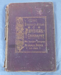
Book - Atlas of Physical Geography
The student's atlas of physical geography consisting of twenty maps, constructed and engraved by Edward Weller F.R.G.S. with descriptive letterpress by James Bryce L.L.D F.R.G.S. Published by William Collins, Sons & Company, London, Glasgow and Edinburgh 1871. Brown cover with the title of the book in gold letters. to the left of the title, also in gold, three circles with different pictures inside. the first of two boats on the sea, a volcanic eruption and a mountain peak.On first page in pencil the name Carrie Van Damme.geography, atlas, 1871 -
Bendigo Historical Society Inc.
Booklet - The Bendigo Naturalist
The Bendigo Naturalist (a set of 5). The Journal of the Bendigo Field Naturalist Club. Vol 5 Nos. 1&2, Vol 6 Nos. 1&2, Vo; 7 No. 2 Each booklet illustrated with B&W photos and maps. Featuring articles and reports on flora and fauna subjects of the Bendigo Area. bendigo naturalist, widlife, flora & fauna -
Bendigo Historical Society Inc.
Booklet - The Eppalock Catchment
Yellow covered booklet of 36 typed and copied pages entitled 'Project for Environmental Education Resources Development. THE EPPALOCK CATCHMENT Sub-Catchment What's Up the Creek? A Resource for Teachers. Includes a diagram of the Water Cycle, 2 maps of the Pohlman's Creek Catchment and Soil Studies. Also includes Pre-Excursion, Excursion and Post- Excursion Activities as well as Record Sheets for Excursions. The name 'Dr W.N.Holsworth' is stamped on the front cover and the date 29 April 1981lake eppalock, catchment study, teachers' resource -
Bendigo Historical Society Inc.
Booklet - Burrow, Burra and 'Borough - a Powell Family History, 1996
Spiral bound pale coloured plastic cover booklet of 82 pages 'Burrow, Burra and 'Borough' a Powell Family History. B&W photo of Powell people on front cover. Compiled and edited by Pauline E Powell 1996 Illustrated with B&W photos and mapsHandwritten comments made against some photspowell, family history -
Bendigo Historical Society Inc.
Book - The Traveller's Guide to the Goldfields, 2006
A soft cover book of 312 pages being a guide, history and natural heritage trails through Central and Western Victoria. Colour photos on front and back covers. Illustrated with maps and numerous colour photos of towns and districts. Published in 2006 by Best Shot! Publications P/L Torquay, Victoria. Printed in Maryborough by McPherson's Printing Group'M & J Qualtrough' sticker on title page Dymocks Booksellers sticker on back cover central and western goldfields, traveller's guide -
 Bendigo Historical Society Inc.
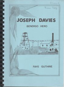
Book - Joseph Davies Bendigo Hero
Joseph Davis : Bendigo Hero (1988) Written by Faye Guthrie. Published by Guthrigg Genealogy, Ringwood Victoria. 224pg Includes b/w photos, copies of letters, maps, and index Acknowledgements - ….and June Parry of the Bendigo Historical Society. Review Copy. Plastic binding.joseph davies, mining rescue, medal -
 Bendigo Historical Society Inc.
Document - NEVILLE KING COLLECTION: OCCUPATION CERTIFICATE HOMESTEAD FARM NO. 15/939 IN THE NAME OF DAVID WILLIAMS AT A COST OF ONE POUND, DATED 25 SEPTEMBER 1897, 1897
Under the Western Australia 'the Homestead act 1893' an Occupation Certificate, Homestead Farm No. 15/939 for David Williams of Bendigo for 160 acres (near Woolkabunning near Bunbury WA); at a cost of one pound. Signed by order of the Commissioner of Crown Lands. Dated 25 September 1897. The land is marked and distinguished in the maps and books of the Department of Lands and Surveys of the said (WA) Colony as Williams Location No. 702. -
 Bendigo Historical Society Inc.
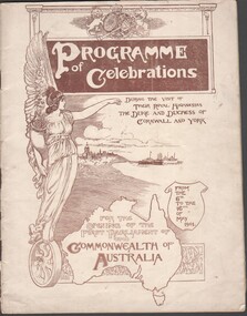
Booklet - JOHN HONES COLLECTION: PROGRAM FOR THE OPENING OF THE FIRST PARLIAMENT OF THE COMMONWEALTH OF AUSTRALIA FROM 6TH TO 16TH MAY 1901
Program for Celebrations for the opening of the First Parliament of the Commonwealth of Australia, from 6th to 16th May 1901 opening during the visit of their Royal Highnesses of the Duke and Duchess of Cornwall and York 48 page program, printed in sepia ink includes photographs, maps and portraits of parliamentary officials -
Bendigo Historical Society Inc.
Photograph - Aerial shots of parts of Bendigo 1934, 1934
AERIAL SHOTS OF PARTS OF BENDIGO 1934 Catalogue No.10584 This document contains scans of a unique set of aerial photographs that were taken over the City of Bendigo on Friday 12th January 1934, at about midday. The photographs were commissioned by Bendigo Mines Limited during their exploration and mining program designed to revitalize the Bendigo Goldfield. The photographs were given to the Victorian Mines Department sometime in the 1950s. The photographs were taken at a relatively low level of about 4000 feet. This gives a very detailed picture of Bendigo as it was in the 1930s. The photos cover the City Centre and are mainly of the goldfields on the south side of the city; the extent of which covers approximately the four corners of Myers Flat, Maiden Gully, Mandurang and One Tree Hill. Streets, roads and places of interest have been identified as best as possible in December 2023. There are 44 maps, and each references the adjoining maps.Typed Notes with CD The CD is one of two and contains a set of 46 images: The folder named "High_Resolution_800dpi" contains the original digital files that were produced by scanning the photographic prints (About A3 size) at 800 dpi using a high quality, large pformat, roll scanner. These files may be too large for some computers. A second CD contains a direstory called "Low_Resolution_300dep" The images in the folder names "Low_Reolution_300dpr" have a lower resolution (300 dpi) and have been rotated 90 degrees clockwise so that the Northern margin of each image is a the top of the screen. Clive Willman Senior Geologist Geological Survey of Victoriahistory, bendigo, bendigo mines, bendigo maps, bendigo aerial photos -
 Bendigo Historical Society Inc.
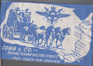
Ephemera - Aileen and John Ellison Collection: Cobb & Co.flag
RFDS was begun by Reverend John Flynn as an aerial Medical Service out of Cloncurry, Queensland in 1928. By 1934 it had expanded across outback Australia. Cobb and Co. was a stagecoach line transporting diggers between the gold fields. There were many coach lines but there names were generalised to "Cobb and Co. It operated between 1853 and 1924.Two small blue and white flag for Cobb & Co. - Royal flying Doctor service 1963 coach run souvenir. The flag has a map of Australia, a horse drawn coach with two men driving, the emblem of the flying doctors and the route from Melbourne to Port Douglas.cobb & co., flying doctors, coach run -
 Bendigo Historical Society Inc.
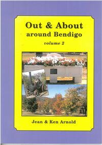
Book - Out and About around Bendigo. Volume 2
BHS CollectionSoft cover book with purple and green colours. Front cover has a photo collage of Bendigo scenes. Back cover has a map of the area covered.plaques, monuments -
 Bendigo Historical Society Inc.
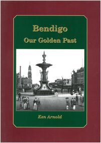
Book - Bendigo Our Golden Past
Historical buildings parks plaques markers and items of interest from first settlement capturing the rich heritage of BendigoBurgundy outer edge with Green insert and gold lettering early photo of Alexandra fountain. Back page various landmarks in Bendigo. 80 Pages - Author Ken ArnoldBook store price tagblack and white plaques and photos, maps of goldfields -
 Bendigo Historical Society Inc.
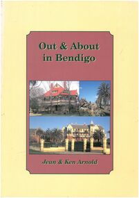
Book - Out & About in Bendigo
Historical markers plaques stones tabulets and photos from an area covering Huntly across to Junortoun to Strathfieldsaye , Mandurang , Big Hill, Maiden Gully and around EaglehawkOut & About in Bendigo - Jean & Ken Arnold Cream outer edge with plum coloured insert with black writing. Front cover Photo Langley Hall Botanical gardens and former Orphanage building Back cover various photos. Pages 80. black and white photos, maps -
 Bendigo Historical Society Inc.
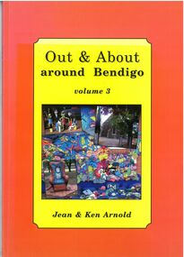
Book - Out & About around Bendigo Volume 3
BHS CollectionOrange outer edge with yellow insert black writing inset of photos Lockwood State School, Maldon photos and Kangaroo Chair Tarnagulla. Back page map of area and various photos. Author Jean and Ken Arnold - 96 Pagesblack and white photos plaques, maps -
 Bendigo Historical Society Inc.
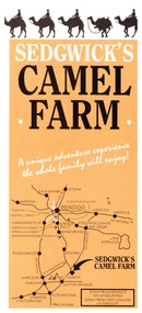
Ephemera - Camel Farm, about 1980s
Now called Mattie's Sanctuary, it provides homes for all livestock animals although there is a particular emphasis on excess male camels from the camel dairies of regional Victoria.Sedgewick Camel Farm and Epsom Market Brochures 1. Camel Farm: Advertising Brochure complete with map of location, hours of operation, tours and prices. 2. Epsom Market, times and phone number, location, times of opening and invitation to become a seller. history, bendigo, merle lummis collection, sedgwick's camel farm, epson market -
Bendigo Historical Society Inc.
Book - Country Towns of Victoria by A.J & J.J. McIntyre
BHS CollectionLight brown hard cover book. 292 pages illustrated with 16 B&W photographs and 4 maps. 36 tables of data relating to Country Towns of Victoria. Authors Jean and Alan McIntyre. Published by Melbourne University Press in 1944. An Ex Libris-plate of Dr. George Mackaness pasted inside front cover. towns, victoria -
 Bendigo Historical Society Inc.
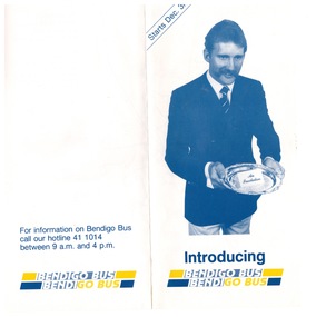
Ephemera - "Bendigo Bus" new routes, 1960 -1970s
BHS CollectionGlossy Brochure introducing "Bendigo Bus" new routes. Map of the new routes and information hotline.history, bendigo, merle lummis collection, bendigo bus -
 Bendigo Historical Society Inc.
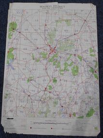
Map - Bush Fire Control Map Bendigo District
A Bush Fire Control map is a valuable tool used by emergency services and communities to respond to respond to bushfires.Cream coloured parchment map showing roads, railway lines, telephone lines, rivers, creeks and water courses. Also marked are houses, Post Offices, Police stations, bush fire brigades, water channels, swamps, marshes, dense, medium and scattered timber, aqueducts and reservoirs. Villages, districts and Towns are clearly marked. Printed in red, green, black and blue. Very clear and easy to read. Undated.bush fires, bendigo area map -
 Bendigo Historical Society Inc.
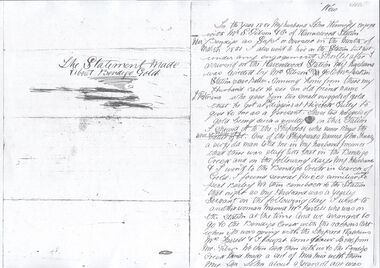
Document - Statement about Bendigo Gold
Photocopy of the statement made by Mrs. Kennedy to the select committee instituted to investigate the claim from Henry Frenchman that he was the discoverer of the Bendigo Goldfields. The committee verdict did not support the claim. Also attached two copies of hand drawn map of the goldfields in 1851.bendigo goldfields, henry frenchman, margaret kennedy, 1851 -
 Bendigo Historical Society Inc.
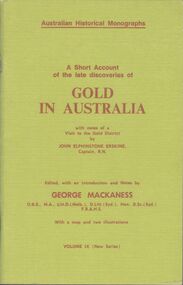
Booklet - Gold in Australia - Australian Historical Monographs - Volume IX
BHS Collection53-page soft lime green cover booklet. A short account of the late discoveries of gold in Australia with notes of a visit to the gold district by Captain John Elphinstone Erskine. Edited by George MacKaness. Australian Historical Monographs Volume IX. Includes a map and 2 illustrations. Printed by D.S.Ford, Sydney Nov 30,1957. Reprint edition by Review Publications, Dubbo, NSW, 1976 gold, australia -
 Bendigo Historical Society Inc.
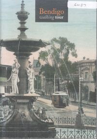
Booklet - Bendigo Walking Tour by Glenn Woodger
52-page soft cover booklet with colour photo of the fountain at Charing Cross on front and back covers. 'Bendigo Walking Tour' authored by Glenn Woodger, June 2003. Includes photos of 58 buildings in Bendigo with a map outlining 3 walking tours. A narrative is included with most photos. A list of references and acknowledgements is given on back page. bendigo, buildings, walking tour -
Bendigo Historical Society Inc.
Booklet - Eaglehawk Cemetery Tours 1& 2
2 x Eleven-page soft blue cover booklets. Eaglehawk Cemetery Tour 1& 2 'Preachers and Publicans' Compiled by Bev Hanson for the Bendigo Cemeteries Trust Museum Committee. Short biography of 17 burials for each Tour with a location maps. General cemetery picture on front covers. Includes short history of the Eaglehawk Monumental Cemetery.eaglehawk cemetery, preachers and publicans -
Bendigo Historical Society Inc.
Booklet - Kangaroo Flat Cemetery Pioneers
Eleven-page green coloured soft cover booklet 'Kangaroo Flat Cemetery Pioneers Tour 1' compiled by Bev Hanson for the Bendigo Cemeteries Trust Volunteer Committee Photo of cemetery entrance on front cover. Ten entries each with a brief biography with location map. Brief history of Kangaroo Flat Cemetery on page 1kangaroo flat, cemeteries, pioneers -
 Bendigo Historical Society Inc.
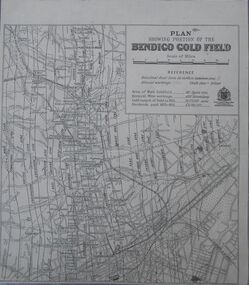
Map - Bendigo Gold Field
... Inc. History House 11 Mackenzie Street Bendigo goldfields Map ...Plan showing portion of the Bendigo goldfield. Area of main goldfield: 140 square miles. Deepest mine working: 4593' (Victoria quartz). Gold output of field to 1935: 20,775,000 ounces. Dividends paid 1870-1935: 10,740,000 pounds.map, goldfield, bendigo -
 Bendigo Historical Society Inc.
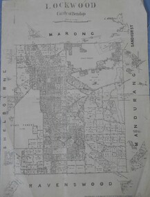
Map - Lockwood County of Bendigo
... Inc. History House 11 Mackenzie Street Bendigo goldfields Map ...A map of Lockwood in the County of Bendigo. On the back in blue pen: Lockwoodmap, lockwood -
 Bendigo Historical Society Inc.
Map - Marong County of Bendigo
... Inc. History House 11 Mackenzie Street Bendigo goldfields Map ...Map of Marong. Drawn and reproduced at the Dept. of Lands and Survey, Melbourne. By authority: W.M. Houston Government Printer. June 1953.On the back in blue pen: certified plan parish Marong, signed minister and seal affixed for land S sec.72 evidence act. I certify that this a true plan parish Marong (signature illegible) minister for lands.map, marong