Showing 6702 items
matching river
-
 Greensborough Historical Society
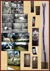
Poster, Lewis C Tulk, My Scout Stave, by Lewis Tulk, 02/02/2018
Lewis Tulk's account of his scouting experiences, including reference to the campsite at Kangaroo Point, Plenty River, Janefield.Laminated poster, with text, black and white and coloured photographs and scout emblem.scouting, lewis tulk -
 Kiewa Valley Historical Society
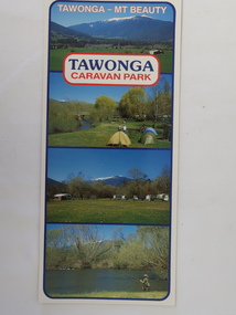
Brochure - Tawonga Caravan Park, Tawonga - Mt Beauty
Tawonga Caravan park is on the Kiewa River situated north of Mt Beauty and 30 km from Falls Creek. Tawonga Caravan park has always been popular for families and fishermen with plenty to do.Colored cardboard brochure with 3 small photos on the front and information printed on the back with a small map.tawonga caravan park, trout fishing -
 Orbost & District Historical Society
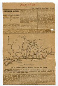
newspaper clippings, 1908; 1958; 1970
These articles were compiled by Mary Gilbert.They have been cut from The Argus, The Age and the Snowy River Mail.These articles are contemporary reports on the transport system in Orbost and as such are useful research tools.A manila folder containing black / white newspaper clippings from various newspapers. The articles are related to transport in Orbost - rail and shipping. (details in Catalogue 735 - 900) -
 Tatura Irrigation & Wartime Camps Museum
Photograph, Goulburn Waranga Main Channel Construction, 1957
Photo taken by the photographer for Victoria State Rivers and Water Supply Commission of the Goulburn Waranga main channel in 1957.Large black and white photograph - dry mounted to cream board. Channel excavation scene with excavator, bucket upraised, in right foreground. Two men looking at something, left foreground. Two small figures mid distance.Below photo: "Goulburn Waranga Main Channel Construction / Bucyrus 200 W. Excavator with 6 c. yd. Bucket / Looking towards off-take at Goulburn Weir / Completed Excavation in Background.goulburn, waranga, irrigation, photo, victoria state rivers and water supply commission -
Tatura Irrigation & Wartime Camps Museum
Photograph, Goulburn Waranga Main Channel Construction, 1957
Photo taken by the photographer for Victoria State Rivers and Water Supply Commission of the Goulburn Waranga main channel in 1957.Large black and white photograph - dry mounted to cream board. Channel excavation scene - with excavator bucket in operation, right foreground. Two men, one arm raised, pointing, in left foregroundBelow photo: "Goulburn Waranga Main Channel Construction / Bucyrus 200 W. Excavator with 6 c. yd. Bucket / Looking towards off-take at Goulburn Weir / Completed Excavation in Background.goulburn, waranga, irrigation, photo, victoria state rivers and water supply commission -
Tatura Irrigation & Wartime Camps Museum
Photograph, Goulburn Waranga Main Channel Construction, 1957
Photo taken by the photographer for Victoria State Rivers and Water Supply Commission of the Goulburn Waranga main channel in 1957.Large black and white photograph - dry mounted to cream board. Channel excavation scene - with excavator bucket in operation / Man operation machine right foreground / Several small indistinct figures mid distance working in channel bed.Below photo: "Goulburn Waranga Main Channel Construction / Bucyrus 200 W. Excavator with 6 c. yd. Bucket / Looking towards off-take at Goulburn Weir / Completed Excavation in Background.goulburn, waranga, irrigation, photo, victoria state rivers and water supply commission -
Tatura Irrigation & Wartime Camps Museum
Photograph, Goulburn Waranga Main Channel Construction, 1957
Photo taken by the photographer for Victoria State Rivers and Water Supply Commission of the Goulburn Waranga main channel in 1957.Large black and white photograph - dry mounted to cream board. Channel excavation scene - with excavator operating right mid distance, scoop bucket operating top of earth wall left mid distance, supervised by figure on top of earth wall.Below photo: "Goulburn Waranga Main Channel Construction / Bucyrus 200 W. Excavator with 6 c. yd. Bucket / Looking towards off-take at Goulburn Weir / Completed Excavation in Background."goulburn, waranga, irrigation, photo, victoria state rivers and water supply commission -
Tatura Irrigation & Wartime Camps Museum
Photograph, Goulburn Waranga Main Channel Construction, 1957
Photo taken by the photographer for Victoria State Rivers and Water Supply Commission of the Goulburn Waranga main channel in 1957.Large black and white photograph - dry mounted to cream board. Channel excavation scene - with excavator operating in mid distance, tractor with rooter in foreground.Below photo: "Goulburn Waranga Main Channel Construction / Channel excavation in progress / 200 W. Bucyrus Dragline, D.8 Caterpillar Tractor with rooter with "Gradall"goulburn, waranga, irrigation, photo, victoria state rivers and water supply commission -
Tatura Irrigation & Wartime Camps Museum
Photograph, Transport office Camp 13, 1950
Shows Army garrison huts in camp 13 Murchison. Taken by photographer for State Rivers and Water Supply Commission.Black and white photograph. Army huts - view looking down main street - transport office on left - poplars and telegraph pole rightvictorian state rivers and supply commission, camp 13, murchison, water commission camp, army garrison huts -
Tatura Irrigation & Wartime Camps Museum
Photograph, Goulburn Waranga Main Channel Construction, 1957
Photo taken by the photographer for Victoria State Rivers and Water Supply Commission of the Goulburn Waranga main channel in 1957.Large black and white photograph - dry mounted to cream board. Channel excavation scene with excavator in right foreground, bucket scooping earth in middle foreground, two small figures of men working mid-distance.Below photo: "Goulburn Waranga Main Channel Construction / Bucyrus 200 W. Excavator with 6 c. yd. Bucket / Looking towards off-take at Goulburn Weir / Completed Excavation in Background.goulburn, waranga, irrigation, photo, victoria state rivers and water supply commission -
Tatura Irrigation & Wartime Camps Museum
Book, Irrigation and Water Supply Development in Victoria, 1954
History of irrigaton in Victoria. Reference to Eildon Reservoir, Goulburn Weir, Waranga Reservoir, River Murray irrigation systemsBuff and blue covered book, showing farmhouse, dairy cattle on front cover, cattle, trees and channel on backirrigation, water supply, goulburn river, books, history, local -
Creswick Campus Historical Collection - University of Melbourne
Sample, 1957
River red gum (E.Camuldelensis) hitching post. Specimen removed from the front of the Bank of NSW Creswick, 1957Wood SpecimenNote the wasting and decay of wood within one foot of ground level. Date of installation unknown. -
 Sunbury Family History and Heritage Society Inc.
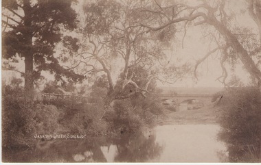
Photograph
The Jacksons Creek and the Macedon Street stone arched bridge are the features in this postcard with a view of a vineyard on the LH river bank. The wine industry was one of the early industries caroused out in Sunbury by the early European settlers in the district.A sepia photograph in post card format of a waterway with overhanging trees and an arched bridge in the middl;e distance.JACKSONS CREEK, SUNBURYjacksons creek, macedon street bridge, vineyards. -
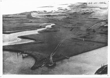 Port Fairy Historical Society Museum and Archives
Photograph, c. 1925
Black and white aerial of Martins Point Moyne River showing dredge. The original signed by R. W. Golding.Black and white landscapelocal history, photography, photographs, slides, film, aerial, martins point, moyne river, dredge -
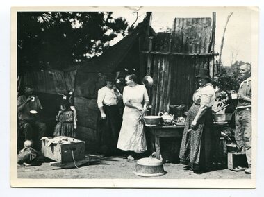 Orbost & District Historical Society
black and white photograph, C1916
This is a photograph of a railway camp, set up to house workers and their families when building the Bairnsdale to Orbost Railway in 1916. The Bairnsdale-Orbost railway was opened in 1916 to serve the agricultural and timber industry. Because of the decline in traffic and heavy operating costs, the line was finally closed in August, 1987. Orbost Railway Station was opened on Monday 10 April 1916 as the terminus of the Orbost railway line, and closed in 1987. The station was located on the west side of the Snowy River despite the town of Orbost being on the east side of the river, in order to save on the costs of a bridge over the river, which at the time had highly variable levels.This item is associated with the history of the Orbost-Bairnsdale railway line and therefore reflects the role that the rail line played in the social and economic history of Orbost.A black / white photograph of a campsite kitchen. The kitchen is outside against a roughly constructed hut. There are three women preparing food. Two men are drinking from tin mugs. a small child is crawling on the ground and another is seated.on back - "Railway Camp"orbost-railway newmerella-railway-camp transport -
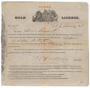 Old Colonists' Association of Ballarat Inc.
Document - Gold License, Gold License issued to Edwin Smart, 28/01/1853
The Old Colonists Association Minute Book records: 'James Smart presented the Association with a Gold Diggers License dated 28th January 1853, it being resolved a vote of thanks be recorded.' The headwaters of the Loddon River rise on the northern slopes of the Great Dividing Range east of Daylesford. The river rises below Musk near Trentham and Lyonville from where it heads northward to Glenlyon and on to Loddon Falls. It then flows generally northward through Guildford and Newstead, 40 kilometres (25 mi) west of Bendigo, then towards the Murray River. The Upper Loddon Plains is within the traditional lands of the Dja Dja Wurrung people.Gold License issued to Edwin Smart on 28 January 1853 at the Upper Loddon.gold license, edwin smart, gold mining, james smart, upper loddon -
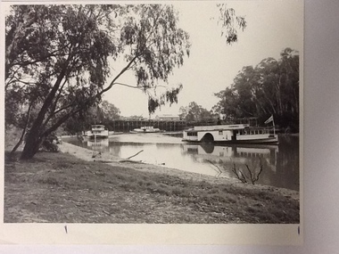 Port of Echuca
Black and white photograph, Approx. 1980
Information of construction of Pride of the Murray. Construction: Composite Tonnage: 71 gross 36 net Dimensions: L 82.4 ft B 15.5 ft D 4.4 Date of Registration: Melbourne 1870 no.88, 918 Built: Echuca, Vic. 1865 Owners: Permewan, Wights & co.This photo has Social and historical significance,depicting some of the boats and the wharf in the 1980's. It gives a very clear visual of the Port of Echuca wharf and the Echuca banks of the Murray with some of the beach visible. Black and white satin photograph of the starboard side of the P. S. Canberra sailing upstream on Murray river between the Port of Echuca wharf and the Echuca bridge. The Pride of the Murray (front on) can be seen further behind , on the left, with the Pevensey, which appears to be moored in front of the wharf in the background. On front of photo paddlesteamers are marked Canberra & Pride of the Murray. On back of the photo is marked in pencil: please return to Mrs H.Coulson, Port of Echuca, Box 35, Echuca.echuca wharf, p.s. canberra -
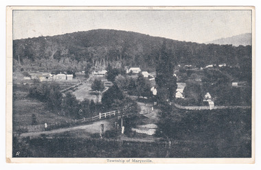 Marysville & District Historical Society
Postcard (item) - Black and white postcard, Nicholas John Caire, Township of Marysville, 1858-1918
One of a series of postcards of photographs taken by socialite photographer Nicholas John Caire. N.J. Caire had a great love for the area and in the late 1800's took many photographs of Marysville and its surrounds.One of a series of postcards of photographs taken by socialite photographer Nicholas John Caire. N.J. Caire had a great love for the area in and surrounding Marysville and in the late 1800's took many photographs of Marysville and its surrounds. N.J. Caire was born in 1837 in Guernsey. He arrived in Adelaide about 1860 along with his parents who encouraged his early interest in photography. He opened a studio in Adelaide in 1867 after traveling extensively throughout the Gippsland taking photographs. After marrying in 1870 he moved to Talbot in Victoria until 1876 when he opened a studio in the Royal Arcade in Melbourne. After 1885 N.J. Caire gave up his city work and made his home in South Yarra and devoted the rest of his life to outdoor photography, specializing in the bush, the gullies and the mountains of south-eastern Victoria. POST CARD The Address to be written on this side This space may be used for Correspondence/ within the Commonwealth at 1d. rate./ Foreign, charged ordinary letter rate. St. Fillans/ Narbethong This is the/ little village we/ visited last week/ E.L. Mrs R.D. Cole/ Mozart Villa/ Bethanga One penny Victorian postage stamp Date Stamp/ Illegible Date Stamp/ JA 16/ 6/ VICTORIA/ Illegiblemarysville, victoria, nicholas john caire, postcard, souvenir -
 Glenelg Shire Council Cultural Collection
Photograph - Photograph - Homestead, Side View, Esther Winifred Hill (Nee Smallpage), 1920
Photographs taken by Esther Winifred Hall (nee Smallpage) - great grand-daughter of Stephen George Henty. Taken in 1934 Centenary Celebrations in Portland.Black and white photograph of house with wide verandah, water tank (on left), behind light-coloured pole and wire fence with metal and wire gate. Donated by Ms. Mary Robinson, acting on behalf of Mrs. W.G. Hutchinson "Tellong", Blackwood River Drive, Balingup, W.A. 6253Front: (no inscriptions) Back: Homestead side view -
Glenelg Shire Council Cultural Collection
Souvenir - Sticker - Glenelg River, n.d
Coloured sticker. Image of Glenelg River at Nelson, oblong, wavy top edge, yellow print along this edge "A Great Place to Relax'; white lettering bottom left hand corner: 'Nelson Victoria'. Sticker attached to white backing, hole in one short end for hanging.souvenir, heywood, nelson, glenelg river -
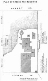 Federation University Historical Collection
Book - Annual Report 1880, The School of Mines Ballaarat Annual Report, 9 February, 1880, 1880
The School of Mines Annual Report, 9 February, 1881, Additional Examination Statute 1880, Balance Sheet, Certificates Granted by Council, Donations and Fees - carriage of, Extracts from Visitors' Book, Fees, Form of Bequest, Honorary Correspondents, Life Governors, Mining and Mineral Contributions Invited - Paper of Particulars, Museum - open to visitors, Office Bearers, Obituary, Report of the Lecturer in Mathematics, Report of the Lecturer in Mining-Land- and Engineering-Surveying, Report of the Lecturer in Mechanical Engineering, Report of the Lecturer in Telegraphy, Report of the Curator of the Museum (with Plans), Report of the Superintendent of Laboratories, Subjects and Lecturers, Subjects and Examiners, Statement of Receipts and Expenditure for the year 1880, Subscriptions and Donations from 1 January to 31 December 1880, The Lal-Lal Iron Ore Deposits - (with Section and Plan)Pale green booklet of 70 pages, Annual Report 1880. Image of Guage Test Tower, Image of The School of Mines, Plan of Ground and Buildings - Albert Street, The School of Mines Ballaarat - The Museum - Plan of Groundfloor, Image of the Lal-Lal Iron Ore Deposits, Moorabool Riverthe school of mines, annual report, additional examination statute 1880, balance sheet, certificates granted by council, donations and fees - carriage of, extracts from visitors' book, fees, form of bequest, honorary correspondents, life governors, mining and mineral contributions invited-paper of particulars, museum open to visitors, office bearers, obituary, report of the lecturer in mathematics, report of the lecturer in mining-land and engineering-surveying, report of the lecturer in mechanical engineering, report of the lecturer in telegraphy, report of the curator of the museum (with plans), report of the superintendent of laboratories, subjects and lecturers, subjects and examiners, statement of receipts and expenditure for the year 1880, subscriptions and donations from 1 january to 31 december 1880, the lal-lal iron ore deposits-(with section and plan), obituary - sir redmond barry - arthur leahy - jacob upfold - john day, mr james oddie, dr. r. f. hudson, john victor, chas. wm. thomas, w. h. shaw, walter d. campbell, ferdinand m. krause, joseph flude, geo. perry, w. hy. barnard, examination statute, his excellency sir wm. f. drummond jervois, charles h. pearson, t. brodribb, professor pepper, james mitchell, robert adam, wm. lant carperter, h. b. de la poer wall, w. h. brokenshire, arthur parker, henry parkinson, c. davies, simon richards, c. v. gorton, c. r. blackett, david jones, wilberforce dyke, ferdinand krause, ballarat school of mines museum, ballarat school of mines museum plan, lal lal ore deposits, moorabool river, william land carpenter, william jervois, william henry tbarnard -
Bendigo Historical Society Inc.
Map - NOLAN : COUNTY OF BENDIGO, 22-7-13
Map. Nolan, County of Bendigo, Egerton, Elmore, Goornong, Northern Railway, Campaspe River. By authority A.J.Mullett, Government Printer, Melbourne. Photo-Lithographed at the Deptartment of Lands and Survey, Melbourne by W.J. Butson 22-7-13. Price 1/-. (number 79 in map cupboard 1)A.J. Mullett, Government Printer, Melbourne.map, bendigo, nolan -
Bendigo Historical Society Inc.
Map - NOLAN : COUNTY OF BENDIGO, 7-5-30
Map. Nolan, County of Bendigo, Egerton, Elmore, Goornong, Campaspe River, Northern Railway. By Authority H.J. Green, Government Printer, Melbourne. Drawn and reproduced at the Department of Lands and Survey, Melbourne, Victoria.7-5-30. Price 2/-. (number 78 in map cupboard 1)H.J. Green, Government Printer, Melbourne.map, bendigo, nolan -
Bendigo Historical Society Inc.
Map - JANIEMBER WEST : COUNTY OF BENDIGO, September 1955
Map. Janiember West, County of Bendigo, Powlett, Janiember East, Jarklan, Kinypanial, River Loddon, Kelsh's Lagoon. By authority W.M. Houston, Government Printer. Drawn and reproduced at the Department of Lands and Survey, Melbourne. Price 2/-.September 1955. (number 64 in map cupboard 1)W.M. Houston, Government Printermap, bendigo, janiember west -
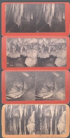 Bendigo Historical Society Inc.
Photograph - WES HARRY COLLECTION: 4 STEROEGRAPHIC CARDS, ?
Four Stereographic cards, all showing views inside of the Jenolan Caves. On the reverse is stamped ' Picturesque Stereoscopic Views of Jenolan Caves and Blue Mountains, Photographed and Published by J. Rowe, Jenolan Caves., (a) Queens Diamonds , (b) Decent to River , (c) Shawls , (d) Jersey Castle ?J. Roweplace, jenolan caves, j. rowe, jenolan caves, blue mountains, stereoscopic views, queens diamonds, decent to river , shawls -
Bendigo Historical Society Inc.
Map - HAWKESTONE : COUNTY OF BENDIGO, December 1953
Map. Hawkestone, County of Bendigo, County of Talbot, Sutton Grange, Redesdale, Faraday, Elphinstone, Metcalfe, Coliban River. By authority W.M. Houston, Government Printer. Drawn and reproduced at the Department of Lands and Survey, Melbourne. December 1953. Price 5/-. (number 97 in map cupboard 1)W.M. Houston, Government Printer.map, bendigo, hawkestone. -
 Port Melbourne Historical & Preservation Society
Album - Projects by Charles Wynn Kiver Allison, Piers, etc, 1920 - 1922
Original photos. Photo album of 48 photos of projects undertaken by Charles Wynn Kiver Allison M.I.E.A.. Namely the New Pier (Princes), Railway Pier, Williamstown, Centre Pier in Victoria Dock, and the Interstate Swinging Basin (near Charles Grimes Bridge) in Yarra River 1920spiers and wharves - miscellaneous, piers and wharves - princes pier, charles wynn kiver allison - miea, victoria dock -
Tatura Irrigation & Wartime Camps Museum
Memorabilia - Photograph
Used in September November 1991 Duplicate photos. Grey with 13 white stripes horizontal. Attractive picture of snow clad mountains - fir trees reflected on the river. Tatura & District Historical Society Museum album. superimposed on the scene. Photographs of exhibits on display. Wartime camps room 1243 top right corner.photographs -
 Kew Historical Society Inc
Slide - Garden, 'Yarra Bluffs', 27 Redmond Street, 1979
One of a group of slides taken by members of the Society of built heritage in Kew in 1979-80. The selection of subject matter reflects the priorities of the period. The colour of some slides has degraded.The slides represent a snapshot in time of built architecture in Kew, much of which has changed in the forty-plus period since they were created.Colour positive transparency (slide) of the garden, facing the river, of the mansion at 27 Redmond Street, Kew, Initially known as 'Yarra Bluffs' or 'Red Bluffs'. The house was built for George H Mott, prominent newspaper owner, prior to 1890. The landholdings of the house were subdivided during the 1940s. "Cnr Redmond and Fellows Streets"historic houses -- kew (vic.), redmond street -- kew (vic.), yarra bluffs, red bluffs, george h mott, victorian mansions -- studley park -
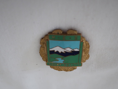 Kiewa Valley Historical Society
Badge Brass - Mt Beauty Higher Elementary School
Schools of this era were very proud of their identity. This was particularly so in country based ones. Schools in isolated or semi-isolated regions provided social cohesion and pride and community involvement that was not so inherent in schools located in larger cities. The exception here being the Greater Public Schools. Mrs Beverly Johnson nee Davis designed the school badges. HES and latter one (Secondary College).Mt Beauty formal secondary education commenced in 1950 with the creation of central classes, with an enrolment of 35 pupils at the Mt Beauty Primary School to serve the children of employees on the Kiewa Hydro Electric Scheme and other people of the district. The Mt Beauty HES was proclaimed on 25th May 1958. In 1962 Mt Beauty High School was proclaimed with 213 pupils. ref. Vision & Realisation Pages 1036-1037. This badge was worn by a local girl.Mt Beauty Higher Elementary School badge made from brass. The front is coloured enamel depicting a scene of sky, mountains, grass and river. On the top it has 'H.E.S.' and on the bottom 'Mount Beauty'. The outside edges are decorated with gold colored ferns. See also KVHS 0371mt beauty higher elementary school, school badge, brass badge