Showing 25659 items
matching plenty-township-estate
-
 Canterbury History Group
Ephemera - A stroll to Maling village, {2000]
Real estate advertisement for the sale of 26 Milton Street Canterbury.Includes a sketch of the house and a floor plancanterbury, milton street -
 National Wool Museum
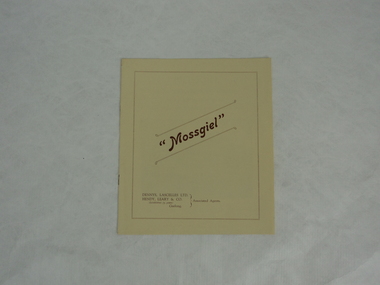
Booklet - Catalogue, Mossgiel, c. 1920
From the collection of a family who had three generations that worked for Dennys Lascelles. This is a catalogue describing the Mossgiel estate for an upcoming auction which was going to be held through the Dennys Lascelles Company. Mossgiel was built for or owned by Brigadier-General Robert Smith, who (I believe) was the founder of the Returned Soldiers & Sailors Mill in Newtown.Cream/pale yellow coloured paper booklet with maroon/brown text and border on front page, "Mossgiel" text in centre. 6 pages, bound with two metal staples on spine. Text and images throughout, describing and showing the Mossgiel estate. Back cover has small drawing of a shield or symbol with flowers below and text reading "LIST. HICKIE. PTY. LTD"dennys lascelles ltd, hendy leary and co, mossgiel -
 Bendigo Historical Society Inc.
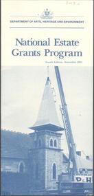
Document - NATIONAL ESTATE GRANTS PROGRAMME, November 1985
Two Documents. Leaflet from the Australian Dept. of Arts, Heritage and Environment describing the National Estate Grants Programme, and a four page typed photocopy headed 'National Estate Grants Programme Guidelines - November 1983. Issued by the Ministry for Planning and Environment, Victoria.Dept. of Arts Heritage and Environment, Canberradocument, dept. of arts, heritage and environment, national estate, grants -
 Bendigo Historical Society Inc.
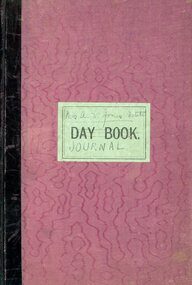
Book - G. ALICE JONES COLLECTION: MRS A.E. JONES ESTATE JOURNAL
Purple with brown spine journal titled Mrs. A. E. Jones Estate Journal. The journal has 188 pages. Written on page 1 ''Annie Elizabeth Jones Estate Journal'' pages 8 et seg and the date 1938 February 21. Pages 2 to 6 a description of the contents of various rooms with a valuation. From page 8 a description of the various assets: real estate, rents, debenture and bonds, mortgages and shares.person, individual, g.alice jones -
 Melbourne Tram Museum
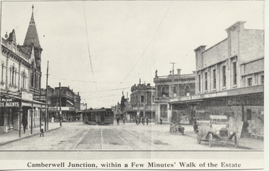
Photograph - Black & White Photograph/s, 1970's
Black and white copy photograph from a Real Estate Poster of a bogie tram (HTT?) turning from Riversdale Road into Camberwell Road, c1920. Has a car (Ford Model T) parked in the street and a motorcycle. Camberwell Junction, Adair Bros, Wilson Real Estate Agents. Post office on the left hand side of the photo with the tower. Has title on photograph "Camberwell Junction, with a Few Minutes' Walk of the Estate"trams, tramways, mmtb, camberwell junction, camberwell rd -
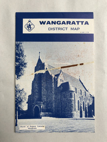 Robin Boyd Foundation
Map, RACV General Insurance, RACV Wangaratta District Map
District Map of Wangaratta and surrounding townshipswangaratta, victoria, map, beechworth, albury-wodonga, walsh st library -
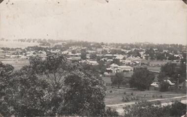 Rutherglen Historical Society
Photograph - Image, 1914-1920 (Approximate)
View across section of Rutherglen TownshipBlack & white photograph, unframed but pasted to pages of an album. Rutherglen"Rutherglen" -
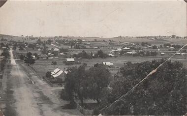 Rutherglen Historical Society
Photograph - Image, 1914-1920 (Approximate)
View looking across township of RutherglenBlack & white photograph, unframed but pasted to pages of an album. Rutherglen"Rutherglen" -
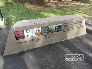 Eltham District Historical Society Inc
Photograph, Shire of Nillumbik World War One Memorials tour, 10 August 2016, 10 August 2016
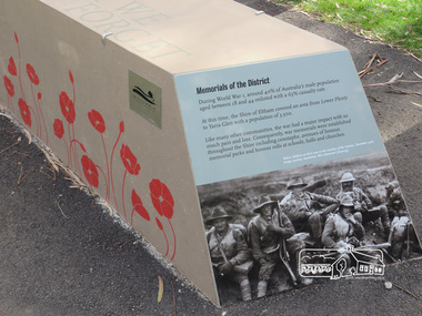
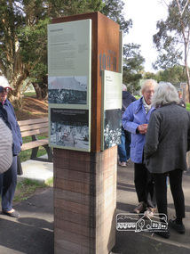
As part of a program to acknowledge the Anzac Centenary Nillumbik Shire Council partnered with Yarra Plenty Regional Library to provide a bus tour with commentary of local sites of significance. These included Eltham township, the Shire of Eltham War Memorial at Kangaroo Ground, Christmas Hills, Hurstbridge memorial recreation park and finished at Eltham Library to view the Writing the War exhibtion at Eltham Library Community Gallery. In June 2014 Nillumbik Shire Council received Anzac centenary Local Grants Program funding to create new interpretative signage that acknowledged the history of the Hurstbridge Memorial Recreation Park as a memorial to all who served in the First World War. Born Digitalworld war 1, war memorials, shire of nillumbik, interpretative signage, hurstbridge -
 Eltham District Historical Society Inc
Photograph, Shire of Nillumbik World War One Memorials tour, 10 August 2016, 10 August 2016
As part of a program to acknowledge the Anzac Centenary Nillumbik Shire Council partnered with Yarra Plenty Regional Library to provide a bus tour with commentary of local sites of significance. These included Eltham township, the Shire of Eltham War Memorial at Kangaroo Ground, Christmas Hills, Hurstbridge memorial recreation park and finished at Eltham Library to view the Writing the War exhibtion at Eltham Library Community Gallery. In June 2014 Nillumbik Shire Council received Anzac centenary Local Grants Program funding to create new interpretative signage that acknowledged the history of the Hurstbridge Memorial Recreation Park as a memorial to all who served in the First World War. Born Digitalworld war 1, war memorials, shire of nillumbik, hurstbridge, interpretative signage -
Kew Historical Society Inc
Booklet - Old Kew Golf Links Estate, 1926
Subdivision plans and real estate flyers/brochures reveal a number of aspects of urban development and history. The Kew Historical Society's collection of these plans, as well as advertisements extracted from magazines, cover key aspects of community development and architectural history of Kew and Kew Eat as well as surrounding suburbs. While most of the plans in the collection were gifted to the Society by the former City of Kew, a number of other plans and advertisements have been donated by individuals, of which this is an example.8-page brochure advertising 80 residential home sites for sale in a subdivision called the 'Old Kew Golf Links Estate'. These sites had historic importance in Kew's history as they had previously belonged to Kodak Pty Ltd who were refused permission by Kew Council to use the land for industrial development. The estate, advertised was advertised as being within five miles of Melbourne. The brochure is notable as it includes photographs of Kew East Primary School, the former Kew Golf Club clubhouse, and 'The Moorings' Boathouse (aka Chipperfield's Boat House). The aerial photograph, overlaid with names of notable sites, on the final page is of interest as it shows the area before the intrusion of the Eastern Freeway, which resulted in changing the course of a section of the Yarra River. old kew golf links estate, subdivision -- kew (vic.), subdivisions -- kew east (vic), chipperfield's boathouse, kew east primary school, kew golf club -
 Kew Historical Society Inc
Plan - Subdivision Plan, Six Big Home Sites, Camberwell North, c.1936
Subdivision plans are historically important documents used as evidence of the growth of suburbs in Australia. They frequently provide information about when the land was sold on which a built structure was subsequently constructed as well as evidence relating to surveyors and real estate and financial agents. The numerous subdivision plans in the Kew Historical Society's collection represent working documents, ranging from the initial sketches made in planning a subdivision to printed plans on which auctioneers or agents listed the prices for which individual lots were sold. In a number of cases, the reverse of a subdivision plan in the collection includes a photograph of a house that was also for sale by the agent. These photographs provide significant heritage information relating house design and decoration, fencing and household gardens.A subdivision in what is currently Balwyn, but which was advertised as being in Camberwell North. The subdivision included six allotments facing Buchanan Avenue and Houghton Street. The subdivision was to the east of the Pointed Firs Estate (1936). In addition to the intrinsic value of this subdivision plan, it also reveals information about the development of transport infrastructure in this area. The subdivision plan notes that the Tramways Board has approved the extension of the tram route past the current terminus at Balwyn Road.subdivision plans - camberwell -
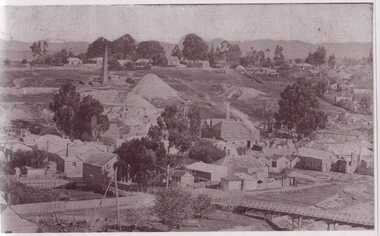
 Bendigo Historical Society Inc.
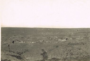
Photograph - ACC LOCK COLLECTION: B&W PHOTO OF A BATTLEGROUND WITH TOWNSHIP IN DISTANCE, PHOTOGRAPH, 1914-1918
Photograph, WW1, B&W photo of a desolate battleground showing gun positions and a township in the far left distance. Handwritten in pencil on the back Gun positions from the duckboards S985 114 114photo, photo, ww1, france, battleground -
 Hume City Civic Collection
Photograph, late 1980s
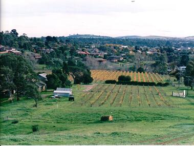
'Craiglee' Winery was established by James Stewart Johnstone in 1865 and the property continued to function as a winery until the late 1920s. The vines were uprooted and the property was used for wool and fat lamb production. In 1961 the Carmody family purchased the property and in 1976 re-established the vineyard.A coloured landscape photograph overlooking Craiglee Winery and vineyard as well as the Sunbury township and its surrounding hills north of the town. A roll of hay is in the foreground and a tractor near out buildings is to the LHS of the photograph.wineries, vineyards, johnstone, james stewart, carmody, patrick, 'craiglee' winery, george evans collection -
 Hume City Civic Collection
Photograph
Housing development spread to the banks of the Jacksons Creek at the east end of the town in the late 1970s.A coloured landscape photograph overlooking the Jacksons Creek and Sunbury township and showing housing development which is taking place on the horse shore bend also known as blueberry island on the opposite creek bank.jacksons creek, blueberry island, george evans collection -
 Hume City Civic Collection
Photograph, Early 1970s
The Kaolin Quarry at Bulla supplied Kaolin to the Northcote and Brunswick Pottery Works until it ceased operation at that site in the 1950s. The three arched bluestone bridge r3placed a ford crossing across Deep Creek, which along with Jacksons Creek flows into the Maribyrnong River.A black and white photograph of the Deep Creek and three arched bluestone bridge in the Bulla Township with the Kaolin Quarry in the background. One truck is crossing the bridge with a tanker approaching the bridge at the bottom of the Bulla Hill.deep creek, bridges, kaolin quarries, quarries, george evans collection -
Lakes Entrance Regional Historical Society (operating as Lakes Entrance History Centre & Museum)
Book, Tract Consultants Australia Pty Ltd and J L Sach and Associates Pty Ltd, Lake Tyers Beach and Surrounds Draft Startegy Plan March 1990, 1986
A development strategy plan prepared by Tract Consultants and J L Sach and Associates, for the Shire of Tambo, focusing in particular on the townships at the Eastern section of the Gippsland Lakes. Minimal consideration is given to the Buchan areagovernment, tourism -
 Clunes Museum
Photograph, KODAK, 1999
VIEW OF POWDER MAGAZINE USED IN MINING DAYS TO STORE EXPLOSIVES. BUILDING MATERIALS SOLID BRICKCOLOURED REPRINT PHOTOGRAPH OF POWDER MAGAZINE EXTERIOR. SITUATED IN A PADDOCK ON SMEATON ROAD APPROX. 2 KM. FROM TOWNSHIP ON LEFT HAND SIDE. SHOWING BRICKED ARCHED ROOF AND END WALL.photography, photographs, mining, powder magazine -
 Clunes Museum
Photograph
.1 BLACK AND WHITE PHOTOGRAPH OF CLUNES TOWNSHIP - FRASER STREET FROM CAMP PARADE C 1897 .2 BOOKLET WITH CREAM COVER TITLE: "A COLLECTION OF HYMNS AND SOLOS FOR SUNDAY SCHOOL ANNIVERSARIES" .1 On Reverse; CLUNES FROM CAMP PARADE ABOUT 1897 On Front; Handwritten in blue ink Port Phillip Hotel - Clunes - From Camp Parade 1895-1900 *Note growth of trees along creek. Planted about 1879 to 1880. Seven Stars Hotel at bend in Fraser Streetlocal history, photography, photographs, clunes township -
 Clunes Museum
Photograph
BLACK AND WHITE PHOTOGRAPH OF CLUNES TOWNSHIP. SMOKE STACKS, MULLOCK HEAPS, TWO POPPET HEADS, TWO BRIDGES OVER CREEK, DWELLINGS. SEVERAL LARGE TREES AND SMALLER TREES IN TREE GUARDS.local history, photography, photographs, clunes township -
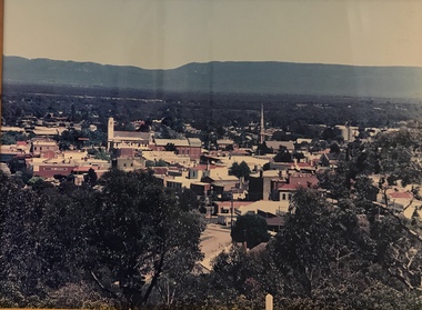 Stawell Historical Society Inc
Photograph, Panorama of Stawell from Big Hill -- Coloured
Colour Laminated photograph and timber framed view of Stawell from Big Hill. c 1998 The Town Hall is at the center of photograph and the National Hotel on the left. The back of buildings can be seen at top of Main Street. Laminated and Framed photograph taken by Irene Read in c 1998 showing view of Stawell from Big Hill -- The Coloured photograph can be identified by trees in the foreground, Stawell township and mountains in background.stawell, panorama, streetscape -
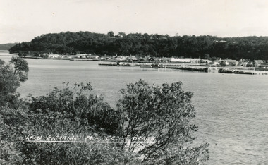 Lakes Entrance Regional Historical Society (operating as Lakes Entrance History Centre & Museum)
Postcard, Bulmer H D, 1950
Black and white postcard of the township of Lakes Entrance, taken form the south bank of Cunninghame Arm, showing the boat haven, buildings along Esplanade, and the Kalimna escarpment in the distance. Lakes Entrance VictoriaOcean Beach at Lakes Entrancetownship, transport -
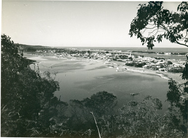 Lakes Entrance Regional Historical Society (operating as Lakes Entrance History Centre & Museum)
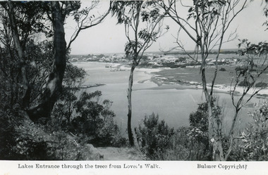
Photograph, 1955
Also black and white postcard, similar view, titled Lakes Entrance through the trees from Lovers Walk. Bulmer copyright.Black and white photograph of a view from Kalimna Heights overlooking township. Shows North Arm, Marine Parade, Cunninghame Arm and sand hummocks with Bass Strait in distance. Lakes Entrance Victoriafishing industry, public works, bridges -
 Lakes Entrance Regional Historical Society (operating as Lakes Entrance History Centre & Museum)
Postcard
Black and white photograph of a view from Kalimna Heights overlooking township. Shows North Arm, Marine Parade, Cunninghame Arm and sand hummocks with Bass Strait in distance. Lakes Entrance Victoria -
 Lakes Entrance Regional Historical Society (operating as Lakes Entrance History Centre & Museum)
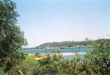
Photograph, Davies, Judy, 2005c
Colour photograph of Jemmys Point, Kalimna Heights, and the Western end of the township, taken from the southern shore of Cunninghame Arm. Small sand spit and natural vegetation in foreground. Lakes Entrance Victoriajetties, waterways, topography, township -
Lakes Entrance Regional Historical Society (operating as Lakes Entrance History Centre & Museum)
Postcard, H D Bulmer, 11920 c
Black and white postcard of township showing first concrete bridge over North Arm swamp land behind buildings on Esplanade low sand dunes on outer barrier Lakes Entrance VictoriaLakes Entrance from Princes Highwayislands, roads and streets -
Lakes Entrance Regional Historical Society (operating as Lakes Entrance History Centre & Museum)
Photograph, L Carpenter, 1952 c
Also three black and white photographs showing sandrifts on hummocks overwhelming coastal banksia trees and other vegetation 04317.1, 04317.2 and 04317.3 12.5 x 13 cm and 15 x 11 cmBlack and white photograph taken on hummocks showing drifting sand overwhelming a stand of coastal banksia trees. Part of western end of township across Cunninghame Arm in distance Lakes Entrance Victoriatownship, waterways -
Lakes Entrance Regional Historical Society (operating as Lakes Entrance History Centre & Museum)
Postcard, Valentine's, 1940 c
Also two other black and white postcards showing similar views 04320.1, 04320.2 size3s 9 x 14 cmBlack and white postcard taken from sand hummocks looking across Cunninghame Arm to township, sandy beach known as Play Point shown left centre of image Lakes Entrance VictoriaLakes Entrance from Front Beach Armtopography, waterways -
 Bendigo Historical Society Inc.
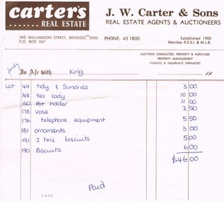
Document - CARTER'S REAL ESTATE INVOICE
Carter's Real Estate Invoice: J.W. Carter & Sons Real Estate Agents & Auctioneers. 295 Williamson Street, Bendigo 3550 Phone 43 1800. Established 1900 Member R.E.S.I & M.L.B Invoice to Ms King for household items. Paid. Box 625business, auctioneers, j.w.carter & sons, j. w. carter & sons. ms king