Showing 10966 items matching " plan."
-
 Federation University Historical Collection
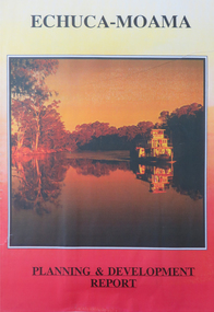
Report, Echuca Moama Tourism Planning and Development Strategy, c1996
Report compiled by three students of 'Tourism Planning and Development' at Ballarat University College (later Federation University Australia).victorian tourism industry, tourism, alumni, echuca, moama, hopwood's ferry, murray river, goulburn river, campaspe river, gaming -
 Federation University Historical Collection
Report, Echuca Moama Tourism Planning and Development Strategy, 1993, 06/1993
Report compiled by four students of 'Tourism Planning and Development' at Ballarat University College (later Federation University Australia).victorian tourism industry, tourism, alumni, echuca, moama, hopwood's ferry, murray river, goulburn river, campaspe river, gaming, port of echuca -
 Federation University Historical Collection
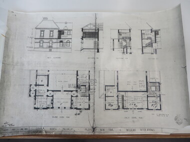
Plan, Court House Ballarat Proposed New Stair & Internal Alterations, 1935, 10/05/1935
Photocopy of a plan of the former Ballarat Supreme Court House showing ground floor, first floor and three sections. former ballarat supreme court house, ballarat school of mines, architectural plans -
 Bendigo Historical Society Inc.
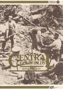
Document - CENTRAL GOLDFIELDS RESTORATION FUND
A document titled ' Central Goldfields Restoration fund.' Ministry for Planning and Environment. A Commonwealth/State Bicentennial Project. 1988.bendigo, planning, goldfields, central goldfields, document, restoration fund, bendigo, history, bendigo history, heritage, bendigo heritage, central goldfields, place, gold, victoria, australian bicentenery -
 Bendigo Historical Society Inc.
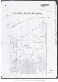
Document - CERTIFICATE OF TITLE
Certificate of titles and its subdivision plans for land bought by George Lansell in Toorak. Dated 27th August 1874.melbourne -
Port Melbourne Historical & Preservation Society
Plan - Bayside development, Port Melbourne, Feb 1987
1987 proposal plan for Bayside development incorporating Princes and Station Piers, with Missions to Seamen Building bordered by canals.town planning - proposals shelved - bayside, sandridge city development company pty ltd, scdc -
Port Melbourne Historical & Preservation Society
Plan - Drainage, Board of Works, William Pentland (Coach builders), corner Ingles Street and Crockford Street, 8 Mar 1905
Board of Works drainage plan for William Pentland (Coach builders) at Ingles St and Crockford St corner. 1905built environment - industrial, sue pentland, william pentland -
Port Melbourne Historical & Preservation Society
Photograph - Participants, Bayside Open Planning Forum, Aug 1992
8 lasercopies of photos of participants in the Bayside Open Planning Forum, held between 6 and 10 August 1992town planning, built environment, bayside development action group, bdag, joh drury, lyn allison, neil robinson, david raynor, leanne matheson, robin edmond, bayside open planning forum, wendy morris, neil beddoe, city engineers -
Port Melbourne Historical & Preservation Society
Plan - Air raid shelter, Engineering Department, City of Port Melbourne, Shelter Type 'A', 7 Jan 1942
Plan for air raid shelter comprising 5'3" reinforced concrete pipe with seating - probably for schoolyard. January 1942.war - world war ii, built environment, city engineers, fred cook -
Port Melbourne Historical & Preservation Society
Document - Specification, Williamstown Road, Derham Street to Raglan Street, Port Melbourne, 14 Mar 1893
Written specification of works attached to plan of Williamstown Road from Derham Street to Raglan Street. (67.1) 1893.A.V. Heath (Town Surveyor). J.J. Bartlett (Mayor).engineering - roads streets lanes and footpaths, arthur victor heath, town clerks, james john bartlett, mayors -
Port Melbourne Historical & Preservation Society
Plan - Soundings, Webb Dock, Port Melbourne, Operation Division, Port of Melbourne Authority, Jul 1987
Port of Melbourne Authority. Plan: soundings taken at Webb Dock, Port Melbourne, Berhs 1 to 5, approachesmelbourne harbor trust - port of melbourne authority, webb dock -
Port Melbourne Historical & Preservation Society
Document - Specification, Metalling and channelling Liardet Street from Esplanade East to Esplanade West, 14 Mar 1893
Specifications (102.1) & Plan (102.2) for metalling and channelling Liardet Street from Esplanade East to Esplanade West 1893..Both signed by J.J. Bartlett. (Mayor).engineering - roads streets lanes and footpaths, town planning, town clerks, mayors, arthur victor heath, james john bartlett, liardet street -
Port Melbourne Historical & Preservation Society
Plan - Metalling and channelling Liardet Street from Esplanade East to Esplanade West, 14 Mar 1893
Specifications (102.1) & Plan (102.2) for metalling and channelling Liardet Street from Esplanade East to Esplanade West 1893..Both signed by J.J. Bartlett. (Mayor).engineering - roads streets lanes and footpaths, town planning, town clerks, mayors, arthur victor heath, james john bartlett -
Port Melbourne Historical & Preservation Society
Plan - Housing Commission Victoria, Erection of State houses, Fishermen's Bend, 1930s
Housing Commission Victoria. Plan of area at Fishermen's Bend Port Melbourne, to be used for erection of State houses. late1930sNotations in Pencil.town planning, garden city, fishermans bend -
Port Melbourne Historical & Preservation Society
Plan - Bow Fender, Inner East berth, Ferry Terminal, Station Pier, Port Melbourne, Port of Melbourne Authority, 1984
Plan - general arrangement of Bow Fender Station Pier - Inner East - Ferry Terminal - preliminary print only.melbourne harbor trust - port of melbourne authority, piers and wharves - station pier -
Port Melbourne Historical & Preservation Society
Plan - Sandridge, 1859
1859 plan of Sandridge. Photocopy made from joined photocopies. Appears that original was joined or reinforced by narrow tapetown planning, sandridge, land sales -
Port Melbourne Historical & Preservation Society
Plan - Woodruff Dairies, Bridge Street and Derham Street, Port Melbourne, Norman C Smith, Architects, 6 Oct 1950
From the Woodruff family archives, 4 photocopies 1950 plans for the Woodruff Dairies at Bridge St and Derham St.industry, business and traders - dairies, woodruff's superior dairies -
Port Melbourne Historical & Preservation Society
Plan - Township of Sandridge, 1855
COPYRIGHT PUBLIC RECORDS OFFICE Plan of the Township of Sandrdge 1855 - copy from Public Record Office 1978local government - municipal district of sandridge, town planning, j jones -
Bendigo Historical Society Inc.
Map - KANGAROO FLAT SUBDIVISION, 26/11/1900
Map: Plan of Subdivision at Kangaroo flat, Parish of Sandhurst, County of Bendigo ( number 149 in Map Cupboard 1)map, bendigo, parish plan, kangaroo flat, parish of sandhurst, county of bendigo -
Bendigo Historical Society Inc.
Map - PLAN OF THE TOWNSHIP OF SANDHURST(PHOTOCOPY)
Map: Photocopy of a plan of the Township of Sandhurst. Dated 26 July 1854 ( number 141 in Map Cupboard 1)map, bendigo, city streets, township of sandhurst, early bendigo, city streets -
Bendigo Historical Society Inc.
Map - NERRING, 15/06/1937
Map: Parish of Nerring, County of Bendigo. Parish plan Canvas backed ( number 139 in Map Cupboard 1)map, bendigo, rural, nerring, county of bendigo -
Bendigo Historical Society Inc.
Map - PARISH OF SANDHURST SHEET 5A, 1970
Map: Parish of Sandhurst Sheet 5A, County of Bendigo. Parish plan ( number 161 in Map Cupboard 1)map, bendigo, parish plan, parish of sandhurst, county of bendigo -
Bendigo Historical Society Inc.
Map - EAGLEHAWK (PART), 22/01/1882
Map: Parish plan showing area Eastward from Lightning Hill ( number 205 in Map Cupboard 1)map, bendigo, parish plan, eaglehawk, lightning hill -
Bendigo Historical Society Inc.
Map - NERRING. SHEET ?, Circa 1894
Map: Nerring, Part ( number unreadable), County of Bendigo. Parish plan ( number 190 in Map Cupboard 1)map, bendigo, parish plan, nerring -
Bendigo Historical Society Inc.
Map - RAYWOOD, 18/09/1930
Map: Township of Raywood, Parish of Neilborough,County of Bendigo. Parish plan (number 270 in map cupboard 1)map, bendigo, township, raywood -
Bendigo Historical Society Inc.
Map - GOORNONG, 1/10/1906
Map: Town of Goornong, Parish of Goornong, County of Bendigo. Parish plan (number 269 in map cupboard 1)map, bendigo, township, goornong -
Bendigo Historical Society Inc.
Map - RAVENSWOOD, April 6th 1872
Map: Township of Ravenswood. Parish plan, has a 1913 calendar as a backing (number 266 in map cupboard 1)map, bendigo, township, ravenswood -
Bendigo Historical Society Inc.
Map - PORTION OF SANDHURST, 27/01/1877
Map: Hand draughted parish plan, showing a portion of the City of Sandhurst ( number 225 in Map Cupboard 1)map, bendigo, parish plan, sandhurst -
Bendigo Historical Society Inc.
Map - SANDHURST (PART), Circa 1880's
Map: Parish plan sowing an area along Specimen Hill Rd. ( number 211 in Map Cupboard 1)map, bendigo, parish plan, specimen hill rd. sandhurst , bendigo -
Bendigo Historical Society Inc.
Map - TARNAGULLA SHEET 1, Examined 25/08/1926
Map: Tarnagulla Sheet 1, Counties of Gladstone and Bendigo. Parish plan (number 304 in map cupboard 1)map, gladstone, parish plan, tarnagulla