Showing 3609 items
matching track
-
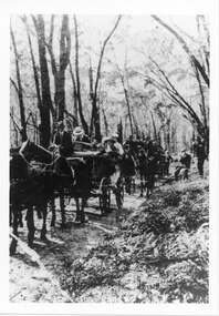 Halls Gap & Grampians Historical Society
Photograph - B/W, C 1900
A group of people on the Stawell-Halls Gap road on their way to an outing at the turn of the 19th century.access routes, jinker track, transport, horse drawn -
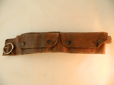 Kiewa Valley Historical Society
Belt Money, Circa 1950
This money, belt made of soft leather, would have been used in the mid 1900's by horse riding traders or wealthy property owners. It could also have been used by miners or other commercial business men. The main criteria for such a belt is security for valuables during travel on horseback. Commercial traders who plied their wares on horseback or caravans during a period where poor roads and flood prone rivers could dislodge wallets or money "sacks".The Kiewa Valley in the early 1900's was an environment which was frequented by the "canny" travelling salesman using dirt tracks and having to cross swollen rivers and creeks throughout the year. Travelling times within the rural areas in and surrounding the valley called for more frequent stops in bush lands. Camping presented itself with great challenges not to loose small cumbersome coin and notes. Local banks were of short supply and although bartering was a thriving method of transactions within the Valley traders from other regions were not so forth coming. Where ever possible local "trades" were called upon more than in city areas for limited products of a rural incline.This "vintage" handcrafted money belt has been professionally made circa 1950's. It appears as though it might have been made in a saddlery. There are five pockets each fastened by black painted "press studs". The stitching is of a high standard and the pockets are large and well defined. The buckle is circular with one fastening pin.handcrafts, leather work, vintage money belt, personal effects. -
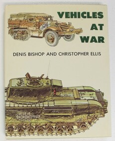 4th/19th Prince of Wales's Light Horse Regiment Unit History Room
Book, Denis Bishop & Christopher Ellis: Vehicles at War, 1979 (exact)
An account of vehicles which have made history in mechanised warfare. Ranging from tanks, armoured cars, personnel carriers, and gun carriers to vehicles such as jeeps, staff cars, ambulances, traction engines and motor cycles. Examples are from many countries and theatres of war, from the Crimean War to the Cold War. Contains 225 colour illustrations and 261 in black & white. ISBN 0-04-623012-2military history, tanks, armoured fighting vehicles, military vehicles, scout car, armoured cars, half track, military history, tanks, armoured fighting vehicles, military vehicles, scout car, armoured cars, half track -
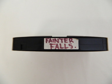 Kiewa Valley Historical Society
Video - Fainter Falls, Fainter Falls, 2003 - 2008
Visual workings and development of the Fainter Falls Trail completed in 2008. The trail was originally accessible via a fire fighting access trail. The fire in the summer of 2003 highlighted the beauty of the area and provided the residents of the Kiewa Valley with the opportunity to consider the redevelopment of the trail. Work to establish a 700 metre grade 2 walking trail with a 50 metre grade 3 extension trail to the Falls began in 2005. It also includes 3 observation decks, a bridge over a creek crossing, car parking and interpretive signage.This video recording is a visual recording of the process of the establishment of the Fainter Falls Walking Trail giving an insight into the process, the work, tools and materials used for such work from 2003 to 2008. It also shows the vegetation in the area and the amount of water flowing at the time.White cardboard cover with black plastic video labelled "Fainter Falls" on outer edge."Fainter Falls"fainter falls. bogong. walking trail. fire track. national parks of victoria -
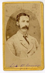 Victoria Police Museum
Carte de Visite (Sub-Insp O'Connor)
A small black and white photograph of Sub-Inspector O'Connor. Shown are the head and shoulder of the man, with a dark moustacheLut. O'Connor P66 (in ink under photograph)sub-inspector o'connor, queensland trackers, kelly gang -
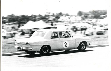 Victoria Police Museum
Photograph (racing car)
Studebaker former Mobile Traffic Section patrol Car with No. 2 painted on driver's door racing at Sandown. Circa 1964wireless patrol; motor transport branch; motor transport section; sandown race track -
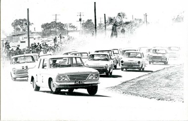
 Victoria Police Museum
Photograph (racing car)
A former Police Studebaker racing at SandownCar with No. 11 painted on driver's door racing at Sandown. Circa 1964wireless patrol; motor transport branch; motor transport section; sandown racing track -
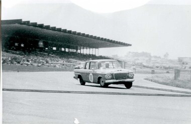
 Victoria Police Museum
Photograph (racing car)
A former Police Studebaker racingCar with No. 2 painted on the driver's door racing at Bathurst. Circa 1965wireless patrol; motor transport branch; motor transport section; bathurst racing track -
 Poowong Historical Group
"Pack Tracks to Pastures", The DCP Group, 2009
A valued historic publication of the Poowong area the first edition written by Ross Hartnell was no longer available.This second edition was published by the Poowong Historical Group with the inclusion of additional photos and also names to previously unnamed photographs. Some corrections to earlier text was also made. The editing and proof reading was carried out by PHG life member and brother of the author Rex Motton with the assistance of PHG life member Heather Gregg who also typeset the second edition.Second edition published 2009 by Poowong Historical Group Inc. Hard back publication. Typeset from the First edition by Heather C Gregg. Copies of this publication are still available for purchase from PHG members @ $30. pack, to, poowong, tracks, pastures -
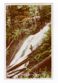
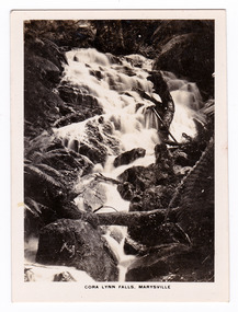 Marysville & District Historical Society
Photograph (item) - Black and white photograph, Rose Stereograph Company, Cora Lynn Falls, Marysville, 1913-1967
An early black and white photograph of the Cora Lynn Falls near Marysville in Victoria.An early black and white photograph of the Cora Lynn Falls near Marysville in Victoria. These falls are located on the Marysville-Wood's Point Road. Cambarville is notable for its giant mountain ash (Eucalyptus regnans) trees within the Cumberland Memorial Scenic Reserve, and relics from former sawmills and gold mining. The Big Culvert is located nearby on the Marysville - Woods Point Road, which was historically part of the Yarra Track. Cambarville was established as a timber mill town in the 1940s. Timber mill owners A Cameron and FJ Barton named Cambarville. They established the mill to salvage timber from trees destroyed in the 1939 bushfires. Cambarville was impacted by the 2009 Black Saturday bushfires and any remaining structures were destroyed. The photograph was also used to produce the Rose Series postcard P. 4947.marysville, victoria, photograph, cora lynn falls, waterfalls, rose series postcard, rose stereograph company, souvenir, cambarville, marysville-wood's point road, eucalyptus regnans, cumberland memorial scenic reserve, mining, big culvert, yarra track, a cameron, fj barton, 1939 bushfires, 2009 black saturday bushfires, timber mills, p. 4947 -
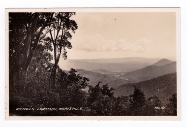
 Marysville & District Historical Society
Photograph (item) - Black and white photograph, Rose Stereograph Company, Nichol's Lookout, Marysville, 1913-1967
An early black and white photograph of the view from Nichol's Lookout which is on the Marysville-Wood's Point Road near Marysville, Victoria.An early black and white photograph of the view from Nichol's Lookout which is on the Marysville-Wood's Point Road near Marysville, Victoria. The photograph was also used to produce the Rose Series postcard P. 2324.marysville, victoria, photograph, nichol's lookout, marysville-wood's point road, p. 2324, rose series postcard, souvenir, rose stereograph company, wood's point, mining, yarra track -
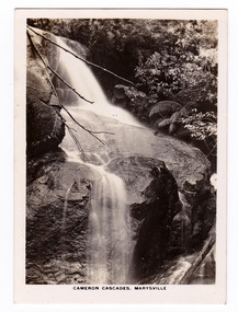 Marysville & District Historical Society
Photograph (item) - Black and white photograph, Rose Stereograph Company, Cameron Cascades, Marysville, 1913-1967
An early black and white photograph of the Cameron Cascades near Marysville, Victoria.An early black and white photograph of the Cameron Cascades near Marysville, Victoria. The Cameron Cascades are off the Lady Talbot Drive. Lady Talbot Drive a 24 kilometer scenic rainforest car journey which passes a number of walks and waterfalls in the Yarra Ranges National Park. Lady Talbot Drive is named after Lady Sarah Elizabeth, the wife of Sir Reginald Talbot, who was the Governor of Victoria from 25th April, 1904 to 6th July 1908. The photograph was also used to produce the Rose Series postcard P. 2313.marysville, victoria, photograph, cameron cascades, waterfalls, cameron cascades track, lady talbot forest drive, p. 2313, rose series postcard, souvenir, rose stereograph company, sir reginald talbot, lady sarah elizabeth talbot -
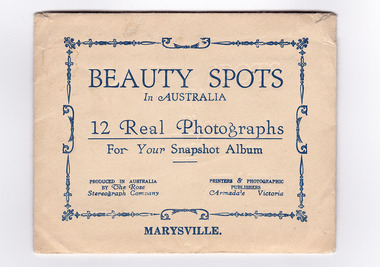 Marysville & District Historical Society
Photograph (item) - Black and white photographs, Rose Stereograph Company, Beauty Spots In Australia-Marysville, 1913-1967
An envelope with 12 black and white photographs of scenic attractions taken in and around Marysville in Victoria. An envelope with 12 black and white photographs of scenic attractions taken in and around Marysville in Victoria. The photographs were used for a series of photographs and postcards published by the Rose Stereograph Company in Armadale, Victoria.12 Real Photographs/ For Your Snapshot Album PRODUCED IN AUSTRALIA/ BY The Rose/ Stereograph Company PRINTERS & PHOTOGRAPHIC/ PUBLISHERS/ Armadale, Victoriakeppel falls (image 1), cumberland falls (image 2), track to cora lynn falls (image 3), nichol's lookout (image 4), cameron cascades (image 5), stevenson falls (image 6), taggerty river (image 7), main street (image 8), taggerty river (image 9), talbot drive (image 10), cora lynn falls (image 11), taggerty river (image 12), rose series postcard, rose stereograph company, souvenir -
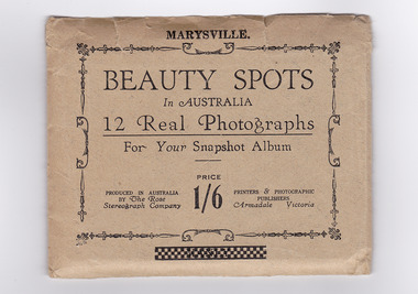 Marysville & District Historical Society
Photograph (item) - Black and white photographs, Rose Stereograph Company, Beauty Spots In Australia-Marysville, 1913-1967
An envelope with 12 black and white photographs of scenic attractions taken in and around Marysville in Victoria. The photographs were used for a series of photographs and postcards published by the Rose Stereograph Company in Armadale, Victoria.An envelope with photographs of scenic attractions taken in and around Marysville in Victoria.12 Real Photographs/ For Your Snapshot Album PRODUCED IN AUSTRALIA/ BY The Rose/ Stereograph Company PRINTERS & PHOTOGRAPHIC/ PUBLISHERS/ Armadale, Victoria PRICE/ 1/6keppel falls (image 1), cumberland falls (image 2), track to cora lynn falls (image 3), nichol's lookout (image 4), cameron cascades (image 5), stevenson falls (image 6), taggerty river (image 7), main street (image 8), glover walk (image 9), from murray pass (image 10), cora lynn falls (image 11), taggerty river (image 12), rose series postcard, rose stereograph company, souvenir -
 Marysville & District Historical Society
Photograph (item) - Colour tinted photograph, Valentine Publishing Co. Pty. Ltd, The Road to Cumberland Valley, Marysville. No. 1, 1923-1963
An early colour tinted photograph of the intersection of the Buxton Marysville Road and the Marysville-Wood's Point Road.An early photograph of the Buxton Marysville Road and the Marysville-Wood's Point Road intersection. The Marysville-Buxton Road joins the Maroondah Highway which leads to Alexandra. The Marysville-Woods Point Road was originally part of the Yarra Track, constructed in the early 1860s to provide access between Healesville and the Woods Point Goldfields. Despite the steep terrain and engineering difficulties, the Yarra Track soon became a busy route used by pack horses, horse-drawn drays, and wagons. Today this sealed mountain road is a popular scenic drive between Marysville and Warburton. On the right of the photograph can be seen 'The Crossways Hotel' which is circa 1920 and one of the oldest buildings still standing in Marysville. 'The Crossways Hotel' survived the 2009 Black Saturday bushfires, through the efforts of the owner using buckets of water from the nearby Steavenson River. In the background can be seen the Poontawan Guest House which later became the Marysville Chalet Guest House which was on the site of the original Steavenson's Hotel. That guest house no longer exists and the Christ Church stands on the land where the guest house once stood. This photograph was published by the Valentine Publishing Co Pty. Ltd as a souvenir of Marysville.marysville, victoria, marysville chalet guest house, crossways hotel, christ church marysville, poontawan guest house, steavenson's hotel, valentine publishing co, souvenir, yarra track, wood's point road, mining, buxton-marysville road, marysville-wood's point road, maroondah highway, alexandra -
 Marysville & District Historical Society
Photograph (item) - Colour tinted photograph, Valentine Publishing Co. Pty. Ltd, Cumberland Falls, Marysville. No.3, 1923-1963
An early colour tinted photograph of the Cumberland Falls near Marysville in Victoria. This photograph was published by the Valentine Publishing Co Pty. Ltd. as a souvenir of Marysville.An early colour tinted photograph of the Cumberland Falls near Marysville in Victoria. These falls are located on the Marysville-Wood's Point Road. Cambarville is notable for its giant mountain ash (Eucalyptus regnans) trees within the Cumberland Memorial Scenic Reserve, and relics from former sawmills and gold mining. The Big Culvert is located nearby on the Marysville-Woods Point Road, which was historically part of the Yarra Track. Cambarville was established as a timber mill town in the 1940s. Timber mill owners A Cameron and FJ Barton named Cambarville. They established the mill to salvage timber from trees destroyed in the 1939 bushfires. Cambarville was impacted by the 2009 Black Saturday bushfires and any remaining structures were destroyed.cumberland falls, waterfalls, marysville, victoria, valentine publishing co, souvenir, a cameron, fj barton, cambarville, marysville-wood's point road, eucalyptus regnans, big culvert, yarra track, timber milling, 1939 bushfires, black saturday bushfires -
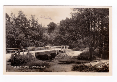 Marysville & District Historical Society
Photograph (item) - Black and white photograph, Valentine Publishing Co. Pty. Ltd, The Old Ford, Marysville No.9, 1923-1963
An early black and white photograph of the old ford in Marysville, Victoria.An early photograph of the bridge at the end of the main street in Marysville which is near the Buxton-Marysville Road and the Marysville-Wood's Point Road intersection. The Marysville-Buxton Road joins the Maroondah Highway which leads to Alexandra. The Marysville-Woods Point Road was originally part of the Yarra Track, constructed in the early 1860s to provide access between Healesville and the Woods Point Goldfields. Despite the steep terrain and engineering difficulties, the Yarra Track soon became a busy route used by pack horses, horse-drawn drays, and wagons. Today this sealed mountain road is a popular scenic drive between Marysville and Warburton. This photograph was published by the Valentine Publishing Co Pty. Ltd as a souvenir of Marysville.marysville, victoria, valentine publishing co, souvenir, buxton-marysville road, marysville-wood's point road, maroondah highway, alexandra, yarra track, mining -
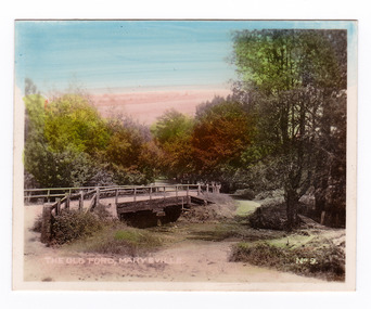 Marysville & District Historical Society
Photograph (item) - Colour tinted photograph, Valentine Publishing Co. Pty. Ltd, The Old Ford, Marysville No.9, 1923-1963
An early colour tinted photograph of the old ford in Marysville, Victoria. This photograph was published by the Valentine Publishing Co Pty. Ltd. as a souvenir of Marysville.An early photograph of the bridge at the end of the main street in Marysville which is near the Buxton-Marysville Road and the Marysville-Wood's Point Road intersection. The Marysville-Buxton Road joins the Maroondah Highway which leads to Alexandra. The Marysville-Woods Point Road was originally part of the Yarra Track, constructed in the early 1860s to provide access between Healesville and the Woods Point Goldfields. Despite the steep terrain and engineering difficulties, the Yarra Track soon became a busy route used by pack horses, horse-drawn drays, and wagons. Today this sealed mountain road is a popular scenic drive between Marysville and Warburton. This photograph was published by the Valentine Publishing Co Pty. Ltd as a souvenir of Marysville.marysville, victoria, valentine publishing co, souvenir, buxton-marysville road, marysville-wood's point road, maroondah highway, alexandra, yarra track, mining -
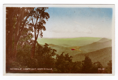 Marysville & District Historical Society
Photograph (item) - Colour tinted photograph, Valentine Publishing Co. Pty. Ltd, Nicoll's Lookout, Marysville No.10, 1923-1963
An early colour tinted photograph of Nicholl's Look-out near Marysville in Victoria. This photograph was published by the Valentine Publishing Co Pty. Ltd. as a souvenir of Marysville.An early colour tinted photograph of Nicholl's Look-out near Marysville in Victoria. This lookout is situated on the Marysville-Wood's Point Road. The Marysville-Woods Point Road was originally part of the Yarra Track, constructed in the early 1860s to provide access between Healesville and the Woods Point Goldfields. Despite the steep terrain and engineering difficulties, the Yarra Track soon became a busy route used by pack horses, horse-drawn drays, and wagons. Today this sealed mountain road is a popular scenic drive between Marysville and Warburton. This photograph was published by the Valentine Publishing Co Pty. Ltd. as a souvenir of Marysville.marysville, victoria, valentine publishing co, souvenir, nicholl's look-out, mining, yarra track -
 Marysville & District Historical Society
Photograph (item) - Black and white photograph, Valentine Publishing Co. Pty. Ltd, Nicoll's Lookout, Marysville No.10, 1923-1963
An early black and white photograph of Nicholl's Look-out near Marysville in Victoria.An early black and white photograph of Nicholl's Look-out near Marysville in Victoria. This lookout is situated on the Marysville-Wood's Point Road. The Marysville-Woods Point Road was originally part of the Yarra Track, constructed in the early 1860s to provide access between Healesville and the Woods Point Goldfields. Despite the steep terrain and engineering difficulties, the Yarra Track soon became a busy route used by pack horses, horse-drawn drays, and wagons. Today this sealed mountain road is a popular scenic drive between Marysville and Warburton. This photograph was published by the Valentine Publishing Co Pty. Ltd. as a souvenir of Marysville.marysville, victoria, valentine publishing co, souvenir, nicholl's look-out, mining, yarra track -
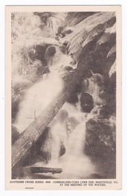 Marysville & District Historical Society
Postcard (item) - Black and white postcard, Rose Stereograph Company, Cumberland-Cora Lynn Trip, Marysville, Vic. At the Meeting of the Waters, 1913-1967
A postcard in a series produced by the Rose Stereograph Company in Victoria, Australia.A black and white photograph of the Cora-Lynn waterfalls at the Meeting of the Waters near the Cumberland Creek. These falls are located on the Marysville-Wood's Point Road. Cambarville is notable for its giant mountain ash (Eucalyptus regnans) trees within the Cumberland Memorial Scenic Reserve, and relics from former sawmills and gold mining. The Big Culvert is located nearby on the Marysville-Woods Point Road, which was historically part of the Yarra Track. Cambarville was established as a timber mill town in the 1940s. Timber mill owners A Cameron and FJ Barton named Cambarville. They established the mill to salvage timber from trees destroyed in the 1939 bushfires. Cambarville was impacted by the 2009 Black Saturday bushfires and any remaining structures were destroyed. This postcard was produced by the Rose Stereograph Company as a souvenir of Marysville.POST CARD. Correspondence/ Addresscora lynn falls, waterfalls, cumberland valley, cumberland creek, marysville, victoria, southern cross series, 4938, postcard, souvenir, meeting of the waters, marysville-wood's point road, cambarville, eucalyptus regnans, big culvert, cumberland memorial scenic reserve, a cameron, fj barton, 1939 bushfires, 2009 black saturday bushfires, rose stereograph company -
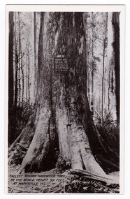 Marysville & District Historical Society
Postcard (item) - Black and white postcard, Valentine Publishing Co. Pty. Ltd, Tallest Known Hardwood Tree in the World, Height 301 Feet at Marysville, Vic. V10, 1923-1963
An early black and white photograph of the Big Tree in Cambarville in Victoria.An early black and white photograph of the Big Tree in Cambarville in Victoria. It was, at one stage, known to be the tallest hardwood tree in the world standing at 92 meters (301ft, 6 inches). However, it was reduced to 84 meters by a wind storm in 1959. It is a mountain ash. There is a walking track through the forest that will take you to the Big Tree. This postcard was published by Valentine Publishing Co. Pty. Ltd. as a souvenir of Marysville.VALENTINE'S/ POST/ CARD A GENUINE PHOTOGRAPHbig tree, mountain ash, cambarville, victoria, valentine publishing co, postcard, souvenir -
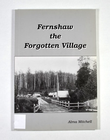 Marysville & District Historical Society
Book - Paperback book, Alma Mitchell, Fernshaw the Forgotten Village, 2001
The story of the village of Fernshaw between the dates of 1864 and 1890.Paperback. Front cover has the title and author's name. Also, a black and white photograph taken by John W. Lindt entitled 'First Glimpse of Fernshaw'.non-fictionThe story of the village of Fernshaw between the dates of 1864 and 1890.fernshaw, victoria, history, watts river, yarra track -
 Marysville & District Historical Society
Postcard (item) - Black and white postcard, Valentine Publishing Co. Pty. Ltd, View From Jock's Lookout, Marysville. V. 21, 1923-1963
An early black and white photograph of the view from Jock's Lookout of Marysville in Victoria. An early black and white photograph of the view from Jock's Lookout of Marysville in Victoria. Jock's Lookout is situated on the Marysville-Wood's Point Road. The Marysville-Woods Point Road was originally part of the Yarra Track, constructed in the early 1860s to provide access between Healesville and the Woods Point Goldfields. Despite the steep terrain and engineering difficulties, the Yarra Track soon became a busy route used by pack horses, horse-drawn drays, and wagons. Today this sealed mountain road is a popular scenic drive between Marysville and Warburton. This postcard was published by the Valentine Publishing Co. Pty. Ltd. as a souvenir of Marysville.VALENTINE'S/ POST CARD/ A GENUINE PHOTOGRAPHjock's lookout, marysville, victoria, postcard, valentine publishing co, souvenir, marysville-wood's point road, yarra track, mining, warburton -
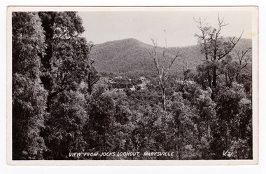
 Marysville & District Historical Society
Postcard (item) - Black and white postcard, Valentine Publishing Co. Pty. Ltd, View From Jock's Lookout, Marysville. V. 21, 1923-1963
An early black and white photograph of the view from Jock's Lookout of Marysville in Victoria.An early black and white photograph of the view from Jock's Lookout of Marysville in Victoria. Jock's Lookout is situated on the Marysville-Wood's Point Road. The Marysville-Woods Point Road was originally part of the Yarra Track, constructed in the early 1860s to provide access between Healesville and the Woods Point Goldfields. Despite the steep terrain and engineering difficulties, the Yarra Track soon became a busy route used by pack horses, horse-drawn drays, and wagons. Today this sealed mountain road is a popular scenic drive between Marysville and Warburton. This postcard was published by the Valentine Publishing Co. Pty. Ltd. as a souvenir of Marysville.VALENTINE'S/ POST CARD/ A GENUINE PHOTOGRAPHjock's lookout, marysville, victoria, postcard, valentine publishing co, souvenir, marysville-wood's point road, yarra track, mining, warburton -
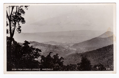 Marysville & District Historical Society
Postcard (item) - Black and white postcard, Valentine Publishing Co. Pty. Ltd, View From Nicholl's Lookout, Marysville. V. 43, 1923-1963
An early black and white photograph of the view of Marysville in Victoria taken from Nicholl's Lookout.An early black and white photograph of the view of Marysville in Victoria taken from Nicholl's Lookout. This lookout is situated on the Marysville-Wood's Point Road. The Marysville-Woods Point Road was originally part of the Yarra Track, constructed in the early 1860s to provide access between Healesville and the Woods Point Goldfields. Despite the steep terrain and engineering difficulties, the Yarra Track soon became a busy route used by pack horses, horse-drawn drays, and wagons. Today this sealed mountain road is a popular scenic drive between Marysville and Warburton. This postcard was published by the Valentine Publishing Co Pty. Ltd. as a souvenir of Marysville.VALENTINE'S/ POST CARD/ A GENUINE PHOTOGRAPHmarysville, nicholl's lookout, victoria, postcard, valentine publishing co, souvenir -
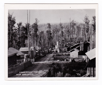 Marysville & District Historical Society
Photograph (item) - Black and white photograph, Valentine Publishing Co. Pty. Ltd, Camberville Township, Near Marysville. V. 35, 1923-1963
An early black and white photograph of the township of Cambarville near Marysville in Victoria.An early black and white photograph of the township of Cambarville near Marysville in Victoria. Cambarville is notable for its giant mountain ash (Eucalyptus regnans) trees within the Cumberland Memorial Scenic Reserve, and relics from former sawmills and gold mining. The Big Culvert is located nearby on the Marysville-Woods Point Road, which was historically part of the Yarra Track. Cambarville was established as a timber mill town in the 1940s. Timber mill owners A Cameron and FJ Barton named Cambarville. They established the mill to salvage timber from trees destroyed in the 1939 bushfires. Cambarville was impacted by the 2009 Black Saturday bushfires and any remaining structures were destroyed. This photograph was produced by Valentine Publishing Co as a souvenir of Marysville.marysville, victoria, photograph, valentine publishing co, souvenir, cambarville, cumberland valley, cumberland scenic reserve, big culvert, marysville-wood's point road, yarra track, a cameron, fj barton, 1939 bushfires, 2009 black saturday bushfires -
 Marysville & District Historical Society
Photograph (item) - Black and white photograph, Valentine Publishing Co. Pty. Ltd, Camberville Township, Near Marysville. V. 35, 1923-1963
An early black and white photograph of the township of Cambarville near Marysville in Victoria.An early black and white photograph of the township of Camberville near Marysville in Victoria. Cambarville is notable for its giant mountain ash (Eucalyptus regnans) trees within the Cumberland Memorial Scenic Reserve, and relics from former sawmills and gold mining. The Big Culvert is located nearby on the Marysville-Woods Point Road, which was historically part of the Yarra Track. Cambarville was established as a timber mill town in the 1940s. Timber mill owners A Cameron and FJ Barton named Cambarville. They established the mill to salvage timber from trees destroyed in the 1939 bushfires. Cambarville was impacted by the 2009 Black Saturday bushfires and any remaining structures were destroyed. This photograph was produced by Valentine Publishing Co as a souvenir of Marysville.marysville, victoria, photograph, valentine publishing co, souvenir, cambarville, cumberland valley, cumberland scenic reserve, big culvert, marysville-wood's point road, yarra track, a cameron, fj barton, 1939 bushfires, 2009 black saturday bushfires -
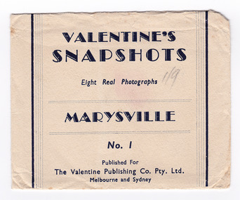 Marysville & District Historical Society
Photograph (item) - Black and white photographs, Valentine Publishing Co. Pty. Ltd, Valentine's Snapshots MARYSVILLE, Victoria, 1923-1963
Early black and white photographs of Marysville and surrounds.This collection of photographs shows various scenes around Marysville and surrounds such as waterfalls, lookouts and local towns. Valentines snapshots were done of many places world wide, and packaged in a convenient size to be posted.VALENTINE'S/ SNAPSHOTS/ 8 Real Photographs/ MARYSVILLE, Victoria/ No. 1/ Published For/ The Valentine Publishing Co. Pty. Ltd./ Melbourne and Sydneymarysville, victoria, valentine publishing co, photograph, souvenir, beautiful ferns on michaeldene track (image 1), cathederal range (image 2), camberville township (image 3), tallest known hardwood tree (image 4), main street marysville (image 5), on black spur road (image 6), stevenson falls (image 7), taggerty valley (image 8) -
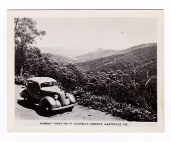 Marysville & District Historical Society
Photograph (item) - Black and white photograph, Murray Views, Murray Views No. 47. Nicholl's Lookout, Marysville, Vic, Post 1929
An early black and white photograph of the view of Marysville taken from Nicholl's Lookout.An early black and white photograph of the view of Marysville taken from Nicholl's Lookout. Nicholl's Lookout is situated on the Marysville-Wood's Point Road. The Marysville-Woods Point Road was originally part of the Yarra Track, constructed in the early 1860s to provide access between Healesville and the Woods Point Goldfields. Despite the steep terrain and engineering difficulties, the Yarra Track soon became a busy route used by pack horses, horse-drawn drays, and wagons. Today this sealed mountain road is a popular scenic drive between Marysville and Warburton. This photograph was produced by Murray Views in Gympie, Queensland as a souvenir of Marysville. nicholl's lookout, marysville, victoria, photograph, murray views, souvenir, marysville-wood's point road, yarra track, mining, warburton