Showing 10966 items matching " plan."
-
 Bendigo Historical Society Inc.
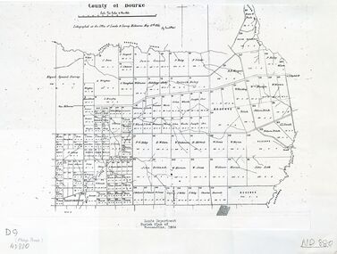
Map - PARISH OF MARONG ALLOTMENTS, No date Visible
Map: Parish of Marong Allotments, County of Bendigo. Parish plan Blueprint (number 286 in map cupboard 1)map, bendigo, allotments, marong allotments -
Bendigo Historical Society Inc.
Map - FOSTERVILLE MAP, 19/08/1897
Map: Township of Fosterville, Parish of Ellesmere, County of Bendigo. Parish plan (number 277 in map cupboard 1)map, bendigo, township, fosterville, ellesmere -
Bendigo Historical Society Inc.
Map - YARRABERB, 17/12/1937
Map: Township of Yarraberb, Parish of Yarraberb, County of Bendigo. Parish plan (number 274 in map cupboard 1)map, bendigo, township, yarraberb -
Bendigo Historical Society Inc.
Map - NEWBRIDGE, August 17th 1875
Map: Township of Newbridge, Parish of Tarnagulla, County of Bendigo. Parish plan (number 272 in map cupboard 1)map, bendigo, township, newbridge -
Bendigo Historical Society Inc.
Map - AXEDALE, 12/07/1909
Map: Township of Axedale, Parish of Axedale, County of Bendigo. Parish plan (number 271 in map cupboard 1)map, bendigo, township, axedale -
Bendigo Historical Society Inc.
Map - CRAVEN'S ALLOTMENTS , NEW CHUM, No date visible
Map: Craven's Allotments, New Chum. Hand Draughted plan showng the corner of McKenzie and Rose streets Bendigo.map, bendigo, allotments, cravens allotments, new chum -
Bendigo Historical Society Inc.
Map - CALAVIL, 28/08/1874
Map: Country Lands, Parish of Calavil, County of Bendigo. Parish plan (number 334 in map cupboard 1)map, bendigo, country lands, country lands, parish of calavil -
Tatura Irrigation & Wartime Camps Museum
Book, Adolf Wilke, 15 September 1944 - 1 May 1946
Surveyors book compiled by POW Adolf Wilke who was lecturer in surveying at Camp 13, Murchison.Handmade hard cover, hand stitched book consisting of figures and plans in ink and pencil. 69 numbered pages.adolf wilke, surveying, camp 13 surveying -
Tatura Irrigation & Wartime Camps Museum
Architect plans, Tatura Methodist Church, 1964
Methodist Church was built and opened on present site (Uniting) in 1959. These extensions completed the building as it now stands.1 of 2 copies (L3264) of complete architects plans and specifications for extensions to Tatura Methodist Church building, 1964. methodist church tatura, alexander harris & assoc. -
Tatura Irrigation & Wartime Camps Museum
Architect plans, Tatura Methodist Church, 1964
Methodist Church was built and opened on present site (Uniting) in 1959. These extensions completed the building as it now stands.1 of 2 copies (L3263) of complete architects plans and specifications for extensions to Tatura Methodist Church building, 1964. methodist church tatura, alexander harris & assoc. -
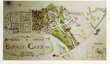 University of Melbourne, Burnley Campus Archives
Slide - Colour slide, Milton Gellert, Department of Agriculture Burnley Gardens Victoria, 1955-1990
Copied for use as a postcard for the Centennial Year in 1990. Note by T.H. Kneen 18 March 1992, "The original drawing was done by Milton Gellert and for a considerable time was displayed in the Fruit Preserving Branch's display window. This was Milton's own concept and was probably done in late 50's. Milton was on Burnley Staff 1955-57 & then employed at Plant Research Institute, Burnley Gardens." The picture was later hung in the Staff Room in the Administration Building but has disappeared.2 copies, large colour negative. Coloured hand drawn plan of of the whole site in a frame. Photographed in 1965.centennial year, milton gellert, fruit preserving branch, staff, plant research institute, burnley gardens, hand drawn plan of site, 1991, plan -
Clunes Museum
Plan - CLUNES TOWN HALL AND COURTHOUSE, 30TH JULY 1892
MADE BY HARRY E SANDO CE; TOWN CLERK & ENGINEER, BOROUGH OF CLUNES, 30TH JULY 1892ACTUAL PLAN OF THE CLUNES TOWN HALL AND COURTHOUSE 1892 DRAWING DONE BY HARRY SANDS, TOWN CLERK AND ENGINEERlocal history, document, plans, town hall -
Stawell Historical Society Inc
Map - Plan, Earle and Partners, Restoration of Pleasant Creek Courthouse Stawell West 1974, 24/10/1974
Drawing 1 Is not in Collection Drawing 5 Landscape Pal is 5092-13 A2 Sheets. Drawing 3 is Elevations. Drawing 2 is Gallery And Roof Plan. Drawing 4 Details24 Oct 74. And 25 Oct 74stawell historical -
Whitehorse Historical Society Inc.
Document, City of Nunawading Forward Planning Special Committee, 1/07/1994 12:00:00 AM
Notice and agenda of Forward planning Committee includes items re Amalgamation submission and proposed names for merged city.Notice and agenda of Forward planning Committee includes items re Amalgamation submission and proposed names for merged city.Notice and agenda of Forward planning Committee includes items re Amalgamation submission and proposed names for merged city.city of nunawading, local government, amalgamations -
Whitehorse Historical Society Inc.
Letter - Correspondence, Abattoir Property, 1937
Letters between City of Box Hill and Shire of Blackburn and Mitcham re sale of abattoir property with a plan of the subdivision.Letters between City of Box Hill and Shire of Blackburn and Mitcham re sale of abattoir property with a plan of the subdivision.Letters between City of Box Hill and Shire of Blackburn and Mitcham re sale of abattoir property with a plan of the subdivision.city of box hill, shire of blackburn and mitcham, abattoirs paddock, aspinall's estate, woodhouse grove, box hill north, aspinall road, box hill north, koonung creek, land subdivision -
Whitehorse Historical Society Inc.
Article, Access grant setback, 1976
Nunawading Learning Exchange suffered a financial loss when it missed out on a further Australian Assistance plan grant.Nunawading Learning Exchange suffered a financial loss when it missed out on a further Australian Assistance plan grant.Nunawading Learning Exchange suffered a financial loss when it missed out on a further Australian Assistance plan grant.city of nunawading, learning exchanges, morris, jo, reach out for kids, nunawading learning exchange -
Whitehorse Historical Society Inc.
Article, School finally opens, 1992
Orchard Grove Primary School has finally opened after nearly six years planning and several 'hiccups'.Orchard Grove Primary School has finally opened after nearly six years planning and several 'hiccups'.Orchard Grove Primary School has finally opened after nearly six years planning and several 'hiccups'.orchard grove primary school, turner, dennis, mirabooka primary school, blackburn south primary school, no. 4035, warrawong primary school -
Whitehorse Historical Society Inc.
Article, Hostel welcomes first residents
After five years of planning and development the Nunawading Community Hostel has taken in its first residents.After five years of planning and development the Nunawading Community Hostel has taken in its first residents. With photo.After five years of planning and development the Nunawading Community Hostel has taken in its first residents.retirement homes and villages, nunawading community hostel, wroe, chris, martin, jan, cavill, margaret, williams, pat, livingstone road, vermont south, no 39 -
Whitehorse Historical Society Inc.
Document, Plans and Specifications, 1948
House Plans and SpecificationsHouse Plans and Specifications for A.H. Schultz and Sons at 26 Owen Street, Mitcham. Approved 15 Dec 1948.House Plans and Specifications plans, owen street, mitcham, no. 26, schultz, a.h. & sons -
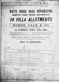 Whitehorse Historical Society Inc.
Document, Hampton Court Estate
Plan of subdivision Hampton Court EstatePlan of subdivision Hampton Court Estate Whitehorse Road, Nunawading 1882. Original in Vale Maps LaTrobe LibraryPlan of subdivision Hampton Court Estate hampton court estate, byrne vale & co. -
Whitehorse Historical Society Inc.
Map, Schwerkolt Museum Extension 2010, 1/06/2010 12:00:00 AM
Plans for construction of an extension of the museum building of the Schwerkolt Cottage & Museum Complex (Visitor Centre).Plans for construction of an extension of the museum building of the Schwerkolt Cottage & Museum Complex (Visitor Centre). Lovell Chen, Architects.Plans for construction of an extension of the museum building of the Schwerkolt Cottage & Museum Complex (Visitor Centre).schwerkolt cottage & museum complex, museum building -
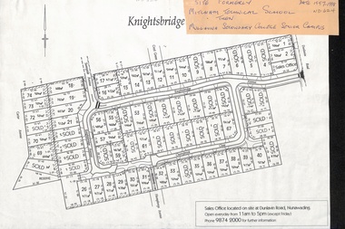 Whitehorse Historical Society Inc.
Map, Knightsbridge Estate, Nunawading, Ca 1997 - 1998
Plan of subdivision of former Mitcham Technical School and later Mullauna Secondary College Senior Campus - Knightsbridge Estate.land subdivision, knightsbridge estate, mitcham technical school, mullauna secondary college, senior campus, cherrybrook close, nunawading, knightsbridge avenue, sunnyside avenue, crest grove, dunlavin road, mitcham, carter avenue, humphreys avenue -
Whitehorse Historical Society Inc.
Document, Crown Grant Register, 10/05/1999
Crown Grant Register - General Law - Parish of Nunawading, 1854 - 1858. Lands Department plan of Parish, 1864.land settlement, victoria. lands department, blood, robert, blood, thomas, burrell, charles, clisby, william, cook, charles, cousens, james, dickensen, william, harding, william, hedding, william, holland, john, jones, william, kefford, richard, lobb, john, morgan, robert rowland, morton, william, o'conner, patrick, orr, joseph, polak, nelson, riley, patrick, smith, l l dr, tranter, william, whitman, francis, williams, william, wilks, joseph, wilson, william, wilton, edward -
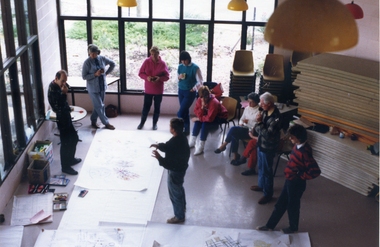 Whitehorse Historical Society Inc.
Photograph, Foyer of Nunawading Arts & Entertainment Centre, 1988
Coloured photo of Crafts People discussing Plans for Bicentenary Leadlight Mural in Foyer of Nunawading Arts & Entertainment Centre.nunawading arts centre, bicentenary leadlight mural, arrowsmith, ted -
 Whitehorse Historical Society Inc.
Map - Nunawading scaled Map, Nunawading, 1864
Parish plan of Nunawading, Lands Department, 1864, showing names of first purchasers of land. Copy also at NP215.parish of nunawading, land settlement, maps -
 Wangaratta High School
WSC School Improvement Plan, 1989
White folder containing school report and analysis documents which form part of the 1989 school improvement plan -
 Bendigo Historical Society Inc.
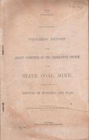
Document - DOCUMENT. PROGRESS REPORT, 1910
Document. Progress Report. Of the Select Committee of the Legislative Council on the State Coal Mine; Together with the Minutes of Evidence and Plan. -
 Ballarat Tramway Museum
Drawing - Drawings by Alwyn Marshall of the Philadelphia Streetcar system, Alwyn Marshall, 1959
Wal Jack had an extensive range of correspondents throughout Australia and the world who often prepared extensive drawings for him. This set of drawings of the extensive Philadelphia streetcar system would have taken many hours to prepare, before the days of colour photocopiers. Parts of the system remain in use.Demonstrates some of the correspondence that Wal Jack received from around the world.Set of 6 ruled foolscap sheets with a drawing or plan of the Philadelphia Streetcar routes and a type note on plain paper. letters, wal jack, tramways, drawings, streetcars, philadelphia, alwyn marshall -
Kew Historical Society Inc
Book, McPhee Gribble, Living Places: twenty houses, 1987
Photographic project commissioned by The State Library of Victoria. "Two hundred of the four hundred photographs taken for the project are to be found at the State Library of Victoria ..."--Introd., p. 6.Fitzroy, Vic. : McPhee Gribble/Penguin, 1987 218 p. : ill., plans ; 21 x 25 cm. non-fictionPhotographic project commissioned by The State Library of Victoria. "Two hundred of the four hundred photographs taken for the project are to be found at the State Library of Victoria ..."--Introd., p. 6.housing -- australia, dwellings -- australia -- social aspects -
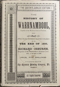 Port Fairy Historical Society Museum and Archives
Book, Richard Osburne, The history of Warrnambool, capital of the western ports of Victoria, from 1847 (when the first government land sales took place) up to the end of 1886, 1980
The history of Warrnambool, capital of the western ports of Victoria, from 1847 (when the first government land sales took place) up to the end of 1886 / by Richard Osburne Other Authors, Fraser, Malcolm, 1930-2015, (author of introduction, etc.) Tylee Memorial Collection368 pages, unnumbered and folded leaves of plates : illustrations (some colour), maps, portraits, plans ; 19 cmnon-fictionThe history of Warrnambool, capital of the western ports of Victoria, from 1847 (when the first government land sales took place) up to the end of 1886 / by Richard Osburne Other Authors, Fraser, Malcolm, 1930-2015, (author of introduction, etc.) Tylee Memorial Collectionvictoria. warrnambool, 1847-1886. facsimiles, government policy - initial period and protectionism., settlement and contacts - 19th century., mining industry - gold., race relations - violent - massacres, religions - christianity - missions., warrnambool (vic.) -- history., framlingham / purnim (w vic sj54-11), demography - census data, book