Showing 5150 items
matching no.627
-
 Beechworth RSL Sub-Branch
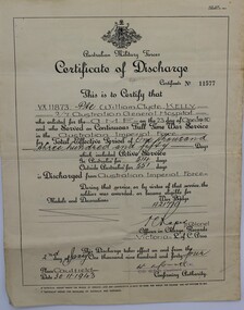
Certificate, Certificate of Discharge (Certificate No: 11577)
... Certificate of Discharge (Certificate No: 11577) ...Presented to Pte William Clyde Kelly on his discharge in 1944 This certificate recognizes Pte Kelly's Service in WWII and is related to his war time service in WWI Certificate of Discharge for Private William Clyde Kelly VX 11873Certifies "VX11873 Pte William Clyde Kelly / 2/7 Australian General Hospital / who enlisted for the A M F on the 23 April 1940 / and who served on Continous Full Time War Service / in the Australian Imperial Force / for a Total Effective Period of One Thousand Three Hundred and Fifty Days / Active Service in Australia 514 days Outside Australia 551 dayscertificate -
 Mont De Lancey
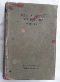
Book, Clement V. Durell, A New Algebra for Schools Parts 1 and 2 - on a separate sheet a Correspondence School Secondary Section. Terminal Report for Lance Sebire No. 1299 1st Test 1st Year 1940, 1930, 1936 Reprint
... for Lance Sebire No. 1299 1st Test 1st Year 1940 ...This is an Algebra textbook for secondary students with an Appendix at the back with Answers along with Supplementary Exercises and tests. Included are illustrations, diagrams and charts. The cover is badly ink stained, loose pages with pencil markings are visible throughout.Very stained grey cloth bound hardcover New Algebra for Schools Parts, 1 and 2 with Appendix and Answers by Clement V. Durell, M.A. Included in the book is a Correspondence School Secondary Section Terminal Report no. 1299 for Lance Sebire 1st test 1st Year 1940. It is signed by his parent, Thomas Sebire.328p. plus Appendix 66p.non-fictionThis is an Algebra textbook for secondary students with an Appendix at the back with Answers along with Supplementary Exercises and tests. Included are illustrations, diagrams and charts. The cover is badly ink stained, loose pages with pencil markings are visible throughout.mathematics, textbooks, algebra -
 The 5th/6th Battalion Royal Victoria Regiment Historical Collection
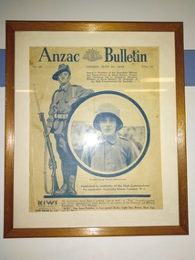
Magazine - Framed Magazine Cover, Anzac Bulletin No. 68 (New Issue). London, April 26, 1918, April 26 1918
... Anzac Bulletin No. 68 (New Issue). London, April 26, 1918 ...Issued to Members of the Australian Military and Naval Forces in Great Britain, France, and elsewhere; by the Authority of the High Commissioner for Australia.Framed copy of the April 26 1918 issue of the Anzac Bulletin. There is a large square picture of a machine gun post on the Western Front. Surrounding this picture is a thin black border with silhouetted kangaroos and emus and a banner with the stars from the Australian flag. A rising sun hat badge is located at the top centre of the light brown page.ww1, wark vc club, print media, anzac bulletin -
The 5th/6th Battalion Royal Victoria Regiment Historical Collection
Magazine - Framed Magazine Cover, Anzac Bulletin No. 70( New Issue) London May 10, 1918, 10 May 1918
... Anzac Bulletin No. 70( New Issue) London May 10, 1918 ...Issued to members of the Australian Military and Naval Forces in Great Britain, France and elsewhere; by the High Commissioner for AustraliaFramed copy of ANZAC BULLETIN Issue 70 from 10 May 1918. There is a large square photo of " the debris of the battlefield" Surrounding this photo is a thin black boarder with small silhouettes of Kangaroos and Emus and a banner across the top containing the stars from the Australian flag. Located at the top and centre of this brown paper magazine cover is the Rising Sun hat badge. -
 The 5th/6th Battalion Royal Victoria Regiment Historical Collection
Magazine - Framed Magazine Cover, Anzac Bulletin No.76 London June 21 1918, June 21 1918
... Anzac Bulletin No.76 London June 21 1918 ...Issued to the members of the Australian Military and Navel Forces in Great Britain, France and elsewhere, and to Australain Munition Workers in Great Britain: by the Authority of the High Commissioner of AustraliaFramed copy of the front cover of the " Anzac Bulletin" issue No. 76. London June 21, 1918. On this cover is a sketch of an Australian soldier in a slouch hat with side up turned holding a SMLE with bayonet affixed leaning on a circular picture of a " Youthful type of German reinforcement". At the base of the page is an ad for Kiwi shoe polish.ww1, wark vc club, anzac bulletin, print media -
 The 5th/6th Battalion Royal Victoria Regiment Historical Collection
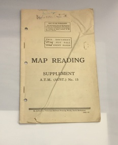
Booklet - Book, Map Reading No. 13 1942, 1942
... Map Reading No. 13 1942 ...Military guide to map readingBook made of yellowed paper with black print. It is bound by two staples and has three holes punched into the left side for storage in a ring binder. There is a crease that runs from the bottom left to the top right of the cover.wark vc club, military manuals, ww2, regimental property -
 Ballarat Heritage Services
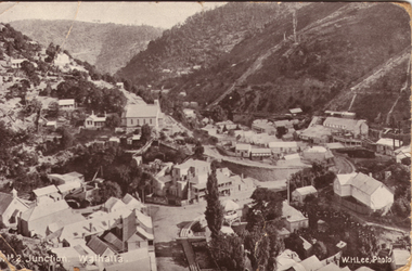
Image - Black and White, W.H. Lee, No. 2 Junction Walhalla, c1908
... No. 2 Junction Walhalla, c1908 ...Black and white photographic postcard of Walhalla, Victoriawalhalla, mining -
 Victorian Bands' League
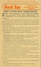
Newsletter, Caulfield Citizens' Band - Band Age (No. 34, December 1952), December 1952
... Caulfield Citizens' Band - Band Age (No. 34, December 1952) ...This is one of two newsletters produced by the Caulfield Citizens' Band titled "Band Age" which detail a little bit of the life and activities of this band. This set of newsletters are significant as they detail the life and activities of a typical brass band in the 1950's. Small newsletter printed on papercaulfield citizens' band, city of glen eira band -
 Victorian Bands' League
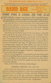
Newsletter, Newsletter - Caulfield Citizens' Band - Band Age (No. 43. September 1953), September 1953
... Newsletter - Caulfield Citizens' Band - Band Age (No. 43 ...This is one of two newsletters produced by the Caulfield Citizens' Band titled "Band Age" which detail a little of the life and activities of this band.This set of newsletters are significant as they detail the life and activities of a typical brass band in the 1950's.Small newsletter printed on papercaulfield citizens' band, city of glen eira band -
 Kew Historical Society Inc
Map, MMBW, MMBW Plan No.39 Kew & Heidelberg, 1900-1910
... MMBW Plan No.39 Kew & Heidelberg ...The Melbourne and Metropolitan Board of Works (MMBW) was established by an act of the Victorian Parliament in 1890 to prepare for and to implement a sewerage and water reticulation system across what was then inner Melbourne, its surrounding and middle distance suburbs, including Kew. The MMBW was disbanded in 1991.The map collection of the Kew Historical Society has at its core the historic maps assembled and originally stored in the City Engineer's Department of the City of Kew. These include maps in a number of scales. The vast majority of maps were produced by the MMBW in the first two decades of the twentieth century, and are solid working maps, backed by linen for durability. These maps are historically significant to Kew, the City of Boroondara and to the history of the development of state utilities in Victoria. A number of the Kew maps have additional details added by former municipal officers, including the levels reached by various floods. As these were working documents, information was added to them long after the period of their initial production and distribution.Early map of part of the Borough of Kew, created in the first decade of the twentieth century, at a scale 160 ft to 1 inch. The map covers what was then the north western section of Kew, bordered on its north by Wills Street and the Kew Lunatic Asylum, in the west by the River Yarra [and the later added Yarra Boulevard] , by Princess Street in the East and Holroyd Street in the south. The map shows the extent of urban development by that time, prominent institutions and the outlines of built structures in the municipality. Contour lines were added in ink to the map at a later stage.MELBOURNE AND METROPOLITAN BOARD OF WORKS / PLAN NO. 39 / KEW & HEIDELBERGmelbourne & metropolitan board of works, mmbw maps, mmbw plans, borough of kew, cartography -
 Kew Historical Society Inc
Map, MMBW, MMBW Plan No.40 Collingwood & Kew, 1900-1910
... MMBW Plan No.40 Collingwood & Kew ...The Melbourne and Metropolitan Board of Works (MMBW) was established by an act of the Victorian Parliament in 1890 to prepare for and to implement a sewerage and water reticulation system across what was then inner Melbourne, its surrounding and middle distance suburbs, including Kew. The MMBW was disbanded in 1991.The map collection of the Kew Historical Society has at its core the historic maps assembled and originally stored in the City Engineer's Department of the City of Kew. These include maps in a number of scales. The vast majority of maps were produced by the MMBW in the first two decades of the twentieth century, and are solid working maps, backed by linen for durability. These maps are historically significant to Kew, the City of Boroondara and to the history of the development of state utilities in Victoria. A number of the Kew maps have additional details added by former municipal officers, including the levels reached by various floods. As these were working documents, information was added to them long after the period of their initial production and distribution.Early map of part of the Borough of Kew, created in the first decade of the twentieth century, at a scale 160 ft to 1 inch. The map covers what was then the south western section of Kew, bordered on its north by Studley Park Road, in the west by Walmer Street and the River Yarra, by High Street South and Princess Street in the East and Barkers Road in the south. The map shows the extent of urban development by that time, prominent institutions and the outlines of built structures in the municipality. Contour lines and historic flood levels were added in ink to the map at a later stage.MELBOURNE AND METROPOLITAN BOARD OF WORKS / PLAN NO. 40 / COLLINGWOOD & KEWmelbourne & metropolitan board of works, mmbw maps, mmbw plans, borough of kew, cartography -
 Kew Historical Society Inc
Map, MMBW, MMBW Plan No.64 Kew & Heidelberg, 1900-1910
... MMBW Plan No.64 Kew & Heidelberg ...The Melbourne and Metropolitan Board of Works (MMBW) was established by an act of the Victorian Parliament in 1890 to prepare for and to implement a sewerage and water reticulation system across what was then inner Melbourne, its surrounding and middle distance suburbs, including Kew. The MMBW was disbanded in 1991.The map collection of the Kew Historical Society has at its core the historic maps assembled and originally stored in the City Engineer's Department of the City of Kew. These include maps in a number of scales. The vast majority of maps were produced by the MMBW in the first two decades of the twentieth century, and are solid working maps, backed by linen for durability. These maps are historically significant to Kew, the City of Boroondara and to the history of the development of state utilities in Victoria. A number of the Kew maps have additional details added by former municipal officers, including the levels reached by various floods. As these were working documents, information was added to them long after the period of their initial production and distribution.Early map of part of the Borough of Kew, created in the first decade of the twentieth century, at a scale 160 ft to 1 inch. The map covers what was then the northern most part of Kew, bordered on its north and west by the Yarra River, in the East by Connor's Creek and by the Asylum in the south. The map shows the extent of urban development by that time, prominent institutions and the outlines of built structures in the municipality. Contour lines and historic flood levels were added in ink to the map at a later stage.MELBOURNE AND METROPOLITAN BOARD OF WORKS / PLAN NO. 64 / KEW & HEIDELBERGmelbourne & metropolitan board of works, mmbw maps, mmbw plans, borough of kew, cartography -
 Kew Historical Society Inc
Map, MMBW, MMBW Plan No.65 Kew & Heidelberg, 1900-1910
... MMBW Plan No.65 Kew & Heidelberg ...The Melbourne and Metropolitan Board of Works (MMBW) was established by an act of the Victorian Parliament in 1890 to prepare for and to implement a sewerage and water reticulation system across what was then inner Melbourne, its surrounding and middle distance suburbs, including Kew. The MMBW was disbanded in 1991.The map collection of the Kew Historical Society has at its core the historic maps assembled and originally stored in the City Engineer's Department of the City of Kew. These include maps in a number of scales. The vast majority of maps were produced by the MMBW in the first two decades of the twentieth century, and are solid working maps, backed by linen for durability. These maps are historically significant to Kew, the City of Boroondara and to the history of the development of state utilities in Victoria. A number of the Kew maps have additional details added by former municipal officers, including the levels reached by various floods. As these were working documents, information was added to them long after the period of their initial production and distribution.Early map of part of the Borough of Kew, created in the first decade of the twentieth century, at a scale 160 ft to 1 inch. The map covers what was then the south central part of Kew, bordered on its north by Malmsbury Street, in the west by Florence Avenue, in the south by Barkers Road, and in the east by Princess Street. The map shows the extent of urban development by that time, prominent institutions and the outlines of built structures in the municipality. Contour lines were added in ink to the map at a later stage.MELBOURNE AND METROPOLITAN BOARD OF WORKS / PLAN NO. 65 / KEW & HEIDELBERGmelbourne & metropolitan board of works, mmbw maps, mmbw plans, borough of kew, cartography -
 Kew Historical Society Inc
Map, MMBW, MMBW Plan No.66 Kew, 1900-1910
... MMBW Plan No.66 Kew ...The Melbourne and Metropolitan Board of Works (MMBW) was established by an act of the Victorian Parliament in 1890 to prepare for and to implement a sewerage and water reticulation system across what was then inner Melbourne, its surrounding and middle distance suburbs, including Kew. The MMBW was disbanded in 1991.The map collection of the Kew Historical Society has at its core the historic maps assembled and originally stored in the City Engineer's Department of the City of Kew. These include maps in a number of scales. The vast majority of maps were produced by the MMBW in the first two decades of the twentieth century, and are solid working maps, backed by linen for durability. These maps are historically significant to Kew, the City of Boroondara and to the history of the development of state utilities in Victoria. A number of the Kew maps have additional details added by former municipal officers, including the levels reached by various floods. As these were working documents, information was added to them long after the period of their initial production and distribution.Early map of part of the Borough of Kew, created in the first decade of the twentieth century, at a scale 160 ft to 1 inch. The map covers what was then the south eastern part of Kew, bordered on its north by Adeney Avenue, in the west by Sackville Street, in the south by Barkers Road, and in the east by Burke Road. The map shows the extent of urban development by that time, prominent institutions and the outlines of built structures in the municipality. Contour lines were added in ink to the map at a later stage.MELBOURNE AND METROPOLITAN BOARD OF WORKS / PLAN NO. 66 / KEW melbourne & metropolitan board of works, mmbw maps, mmbw plans, borough of kew, cartography -
 Kew Historical Society Inc
Map, MMBW, MMBW Plan No.67 Kew, 1900-1910
... MMBW Plan No.67 Kew ...The Melbourne and Metropolitan Board of Works (MMBW) was established by an act of the Victorian Parliament in 1890 to prepare for and to implement a sewerage and water reticulation system across what was then inner Melbourne, its surrounding and middle distance suburbs, including Kew. The MMBW was disbanded in 1991.The map collection of the Kew Historical Society has at its core the historic maps assembled and originally stored in the City Engineer's Department of the City of Kew. These include maps in a number of scales. The vast majority of maps were produced by the MMBW in the first two decades of the twentieth century, and are solid working maps, backed by linen for durability. These maps are historically significant to Kew, the City of Boroondara and to the history of the development of state utilities in Victoria. A number of the Kew maps have additional details added by former municipal officers, including the levels reached by various floods. As these were working documents, information was added to them long after the period of their initial production and distribution.Early map of part of the Borough of Kew, created in the first decade of the twentieth century, at a scale 160 ft to 1 inch. The map covers what was then the north central part of Kew, bordered on its north by the Outer Circle Railway Spruzen and Beresford Avenues, in the west by Princess Street, in the south by High Street, and in the east by (about) Belford Road. The map shows the extent of urban development by that time, prominent institutions and the outlines of built structures in the municipality. Contour lines were added in ink to the map at a later stage.MELBOURNE AND METROPOLITAN BOARD OF WORKS / PLAN NO. 67 / KEW melbourne & metropolitan board of works, mmbw maps, mmbw plans, borough of kew, cartography -
 Kew Historical Society Inc
Map, MMBW, MMBW Plan No.68 Kew, 1900-1910
... MMBW Plan No.68 Kew ...The Melbourne and Metropolitan Board of Works (MMBW) was established by an act of the Victorian Parliament in 1890 to prepare for and to implement a sewerage and water reticulation system across what was then inner Melbourne, its surrounding and middle distance suburbs, including Kew. The MMBW was disbanded in 1991.The map collection of the Kew Historical Society has at its core the historic maps assembled and originally stored in the City Engineer's Department of the City of Kew. These include maps in a number of scales. The vast majority of maps were produced by the MMBW in the first two decades of the twentieth century, and are solid working maps, backed by linen for durability. These maps are historically significant to Kew, the City of Boroondara and to the history of the development of state utilities in Victoria. A number of the Kew maps have additional details added by former municipal officers, including the levels reached by various floods. As these were working documents, information was added to them long after the period of their initial production and distribution.Early map of part of the Borough of Kew, created in the first decade of the twentieth century, at a scale 160 ft to 1 inch. The map covers what was then the north central part of Kew, bordered in the north by Oak Avenue, in the west by the Yarra River and Connor's Creek, in the south by Beresford and Carnegie Avenues, and in the east by Glass's Creek and Burke Road. The map shows the extent of urban development by that time, prominent institutions and the outlines of built structures in the municipality. Contour lines and the levels of historic floods were added in ink to the map at a later stage.MELBOURNE AND METROPOLITAN BOARD OF WORKS / PLAN NO. 68 / KEW melbourne & metropolitan board of works, mmbw maps, mmbw plans, borough of kew, cartography -
 Kew Historical Society Inc
Map, MMBW, MMBW Plan No.117 Heidelberg & Kew, 1900-1910
... MMBW Plan No.117 Heidelberg & Kew ...The Melbourne and Metropolitan Board of Works (MMBW) was established by an act of the Victorian Parliament in 1890 to prepare for and to implement a sewerage and water reticulation system across what was then inner Melbourne, its surrounding and middle distance suburbs, including Kew. The MMBW was disbanded in 1991.The map collection of the Kew Historical Society has at its core the historic maps assembled and originally stored in the City Engineer's Department of the City of Kew. These include maps in a number of scales. The vast majority of maps were produced by the MMBW in the first two decades of the twentieth century, and are solid working maps, backed by linen for durability. These maps are historically significant to Kew, the City of Boroondara and to the history of the development of state utilities in Victoria. A number of the Kew maps have additional details added by former municipal officers, including the levels reached by various floods. As these were working documents, information was added to them long after the period of their initial production and distribution.Early map of part of the Borough of Kew, created in the early twentieth century, at a scale 160 ft to 1 inch. The map covers what was then the north eastern part of Kew showing the natural landscape and limited development on the south side of the Yarra River. In the Kew section, south of the river, the land is occupied currently by the Greenacres and Kew Golf Clubs. The map shows the extent of urban development by that time and the outlines of the few built structures in the municipality. The height above sea level of all parts of the landscape are indicated numerically in feet. Contour lines and the levels of historic floods were added in ink to the map at a later stage. MELBOURNE AND METROPOLITAN BOARD OF WORKS / PLAN NO. 117 / HEIDELBERG & KEW melbourne & metropolitan board of works, mmbw maps, borough of kew, cartography, mmbw plan no. 117, kew (vic.) -- maps, heidelberg (vic.) -- maps -
 Kew Historical Society Inc
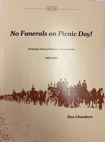
Book, Don Chambers, No funerals on picnic day! : Victorian funeral industry associations, 1890-1990, 1990
... No funerals on picnic day! : Victorian funeral industry ...East Kew, Vic. : Australian Funeral Directors Association Victorian Division, 1990. xiv, 157 p. : ill. ; 28 cm. Includes index. Available from The Association, 722 High St, East Kew Vic 3102. Bibliography: p. 135.non-fictionundertakers and undertaking -- victoria -- history. -
 Power House Rowing Club
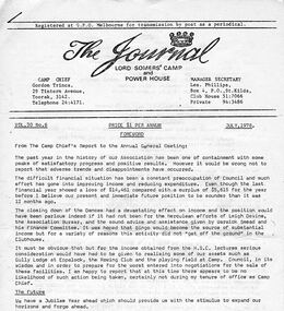
Newsletter, The Journal - Lord Somers' Camp and Power House - Vol.30 No.6 JULY, 1978, July 1978
... The Journal - Lord Somers' Camp and Power House - Vol.30 No ...The Journal - Lord Somers' Camp and Power House - Vol. 30 No.6 JULY, 1978 Registered at G.P.O. Melbourne for transmission by post as a periodical The Journal LORD SOMERS' CAMP and POWER HOUSE CAMP CHIEF Gordon Trinca 29 Tintern Avenue, Toorak, 3142. Telephone 24:4171. MANAGER SECRETARY Les. Phillips, Box 4, P.O. , St.Kilda, Club House 51:7066 Private 94:3486 Vol. 30 No.6 JULY, 1978 -
 Mont De Lancey
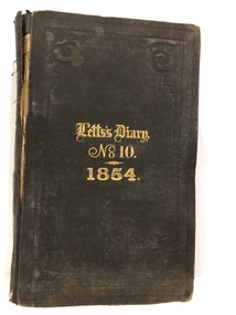
Diary, Letts’s Diary No. 10 1854
... Letts’s Diary No. 10 1854. ...Diary of Mr. Simon Blagdon 1854. Pages give story of Eureka Stockade and Crimean War, a note that Steamship arrives with mail. Mr. Blagdon was a senior Postal official, who died 1893 in Hawthorn, Victoria. Brown diary with gold lettering on cover"Letts's Diary No 10. 1854"diaries -
Bendigo Trades Hall Council & Literary Institute Inc.
Book, Official Year Book of the Commonwealth of Australia No. 34 1941
... Official Year Book of the Commonwealth of Australia No. 34 ...Hard Binder Book with aprox. 952 pagesOfficial Year Book of the Commonwealth of Australia No. 34 1941 -
Bendigo Trades Hall Council & Literary Institute Inc.
Book, Official Year Book of the Commonwealth of Australia No. 35 1942-43
... Official Year Book of the Commonwealth of Australia No. 35 ...Hard Binder Book with aprox. 992 pagesOfficial Year Book of the Commonwealth of Australia No. 35 1942-43 -
Bendigo Trades Hall Council & Literary Institute Inc.
Book, Year book Australia 1968 no. 54
... Year book Australia 1968 no. 54 ...BookYear book Australia 1968 No. 54 Commonwealth Bureau of Census and Statistics -
Bendigo Trades Hall Council & Literary Institute Inc.
Book, Year book Australia 1969 No 55
... Year book Australia 1969 No 55 ...Book Year book Australia 1969 no. 55 Commonwealth Bureau of Consus and Statistics -
 Carlton Football Club
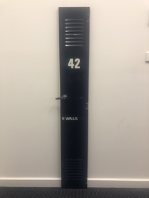
Locker door, No.42, R. Walls, Circa 1960s
... No.42, R. Walls ...This locker door was used by the Carlton Premiership player of 1968, 1970 and 1972, Robert Walls. Walls played 218 games for Carlton between 1967 and '78. The locker carries his name because he wore the No.42 into 100 senior games for the club - the minimum number of games required by a player to earn that honour. This item is one of the few of its type remaining with the club, and Robert Walls is an important figure in Carlton FC history as both Carlton Premiership player (1968, 1970 and 1972) and Senior Coach (1987). The locker room is considered the inner sanctum of the players, hence the significance.1.5m x 25m x 2.5cm steel louvred dark navy blue locker with white enamel No.42 and R. Walls, silver handle. At rear on left side below louvre, white powder coated, with inscription GOOD BOY BANGER! in fading black fineliner, and GOOD BOY POTS AND PANS!, plus various other markings. Slight rust. At rear on left side below louvre, white powder coated, with inscription GOOD BOY BANGER! in fading black fineliner, and GOOD BOY POTS AND PANS!, plus various other markings. locker, no.42, robert walls, carlton football club, robert heatley stand, locker room -
 Rutherglen Historical Society
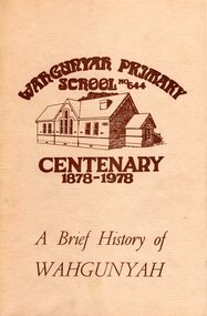
Booklet, Sun Print, Wahgunyah Primary School No. 644, Centenary 1878-1978: A Brief History of Wahgunyah, 1978
... Wahgunyah Primary School No. 644, Centenary 1878-1978: A ...The Wahgunyah Centenary Committee published this book for the celebration in 197836 page booklet with beige cover and brown lettering, with a sketch of Wahgunyah School.wahgunyah primary school no 644, wahgunyah, schools -
 Ringwood RSL Sub-Branch
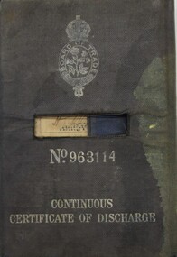
Document Certificate of Discharge, Board of Trade No, 963114
... Board of Trade No, 963114 ...Issued to Harry Webb - merchant seaman born 1901 in London - last entry 1921.12pages plus loose sheets. Continuous Certificate of Discharge -
 Rutherglen Historical Society
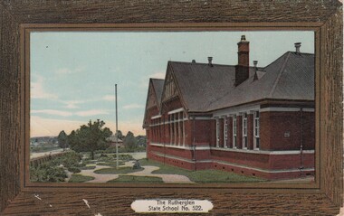
Postcard - Image, W. Hine Bookseller, The Rutherglen State School No. 522, c1890
... The Rutherglen State School No. 522 ...Postcard showing coloured photograph, in a brown printed frame, of a brick school building.school buildings, rutherglen state school -
 Rutherglen Historical Society
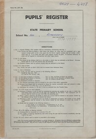
Document - School Records - Register, A.C. Brooks Govt. Printers, Pupils' Register. State Primary School. School No. 522, Rutherglen, 1974-1977
... Pupils' Register. State Primary School. School No. 522 ...Handwritten pupil register. Cover printed with the title "Pupils' Register. State Primary School. School No." followed by a space for the school number and name to be written in. The remainder of this cover contains printed directions to aid the entry of information about pupil enrolments.Written in ink on top right of the cover: "4029-4208" Written in pencil below the name of the school: "1974-1977" teacher records, rutherglen, state primary school, pupils, students, school reports, rutherglen state primary school no 522 -
 Rutherglen Historical Society
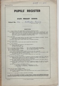
Document - School Records - Register, C.H. Rixon, Government Printer, Pupils' Register. State Primary School. School No. 522, Rutherglen Primary, 1977-1980
... Pupils' Register. State Primary School. School No. 522 ...Handwritten pupil register. Cover printed with the title "Pupils' Register. State Primary School. School No." followed by a space for the school number and name to be written in. The remainder of this cover contains printed directions to aid the entry of information about pupil enrolments.Written in ink on top right of the cover: "4209-4388" teacher records, rutherglen, state primary school, pupils, students, school reports, rutherglen state primary school no 522