Showing 9778 items
matching east street
-
 St Kilda Historical Society
Photograph - Photo map, 28/01/1951
One of a series of photo-maps produced for the Department of Crown Lands and Survey (1857-1983). For correlation with a current map, and access to other historical photo maps of Victoria, see the Historic Photo-Maps Index published by the Department of Environment, Land, Water and Planning at https://services.land.vic.gov.au/DELWPmaps/historical-photomaps/Black and white aerial photograph1424-43 534 Run 18 Lens 12" Melbourne Metropolitan 12150 28.1.51 M639armadale, malvern, st kilda cemetery, caulfield north, st kilda east, 1951 -
 St Kilda Historical Society
Photograph - Photo map, 30/01/1960
One of a series of photo-maps produced for the Department of Crown Lands and Survey (1857-1983). For correlation with a current map, and access to other historical photo maps of Victoria, see the Historic Photo-Maps Index published by the Department of Environment, Land, Water and Planning at https://services.land.vic.gov.au/DELWPmaps/historical-photomaps/Black and white aerial photographVic 1092-40 Melbourne & Metropolitan Project Run 22 30.1.60 Lens 10" 8.200st kilda east, balaclava, ripponlea, st kilda cemetery, 1960 -
 St Kilda Historical Society
Photograph - Photo map, 30/01/1960
One of a series of photo-maps produced for the Department of Crown Lands and Survey (1857-1983). For correlation with a current map, and access to other historical photo maps of Victoria, see the Historic Photo-Maps Index published by the Department of Environment, Land, Water and Planning at https://services.land.vic.gov.au/DELWPmaps/historical-photomaps/Black and white aerial photographVic 1091-110 Melbourne & Metropolitan Project Run 23East 30.1.60 Lens 10" 8.200elwood, elsternwick, elsternwick park, ripponlea, st kilda east, caulfield, balaclava, 1960 -
 St Kilda Historical Society
Photograph - Photo map, 14/12/1963
One of a series of photo-maps produced for the Department of Crown Lands and Survey (1857-1983). For correlation with a current map, and access to other historical photo maps of Victoria, see the Historic Photo-Maps Index published by the Department of Environment, Land, Water and Planning at https://services.land.vic.gov.au/DELWPmaps/historical-photomaps/Black and white aerial photographVic 1807 Melbourne 1963 Project Run 16 14.12.63 Lens 205 152.70 M/M 5.150 179st kilda, prahran, albert park, st kilda east, balaclava, 1963 -
 St Kilda Historical Society
Photograph - Photo map, 14/12/1963
One of a series of photo-maps produced for the Department of Crown Lands and Survey (1857-1983). For correlation with a current map, and access to other historical photo maps of Victoria, see the Historic Photo-Maps Index published by the Department of Environment, Land, Water and Planning at https://services.land.vic.gov.au/DELWPmaps/historical-photomaps/Black and white aerial photographVic 1807 Melbourne 1963 Project Run 16 14.12.63 Lens 205 152.70 M/M 5.150 181st kilda cemetery, caulfield north, st kilda east, armadale, malvern, 1963 -
 St Kilda Historical Society
Photograph - Photo map, 12/04/1966
One of a series of photo-maps produced for the Department of Crown Lands and Survey (1857-1983). For correlation with a current map, and access to other historical photo maps of Victoria, see the Historic Photo-Maps Index published by the Department of Environment, Land, Water and Planning at https://services.land.vic.gov.au/DELWPmaps/historical-photomaps/Black and white aerial photographVic 1933 Melbourne 1966 Project Run 12 12.4.66 Lens 122 151.75MM 9.800 154st kilda, st kilda east, balaclava, toorak, amadale, caulfield, south yarra, st kilda botanical gardens, peanut farm, 1966 -
 St Kilda Historical Society
Photograph - Photo map, 08/02/1966
One of a series of photo-maps produced for the Department of Crown Lands and Survey (1857-1983). For correlation with a current map, and access to other historical photo maps of Victoria, see the Historic Photo-Maps Index published by the Department of Environment, Land, Water and Planning at https://services.land.vic.gov.au/DELWPmaps/historical-photomaps/Black and white aerial photographVic 1916 Melbourne 1966 Project Run 13 E 8.2.66 Lens 122 151.75MM 9.800 111st kilda, balaclava, caulfield, caulfield north, st kilda east, elsternwick, elsterwick park, elwood park, elwood canal, elwood beach, ripponlea, 1966 -
 St Kilda Historical Society
Photograph - Photo map, 11/01/1968
One of a series of photo-maps produced for the Department of Crown Lands and Survey (1857-1983). For correlation with a current map, and access to other historical photo maps of Victoria, see the Historic Photo-Maps Index published by the Department of Environment, Land, Water and Planning at https://services.land.vic.gov.au/DELWPmaps/historical-photomaps/Black and white aerial photographVic 2132 State Aerial Survey Melbourne 1968 Proj Run 27E 11.1.68 5100 ASL 67st kilda east, st kilda cemetery, caulfield north, alma park, balaclava, armadale, 1968 -
 St Kilda Historical Society
Photograph - Photo map, 11/01/1968
One of a series of photo-maps produced for the Department of Crown Lands and Survey (1857-1983). For correlation with a current map, and access to other historical photo maps of Victoria, see the Historic Photo-Maps Index published by the Department of Environment, Land, Water and Planning at https://services.land.vic.gov.au/DELWPmaps/historical-photomaps/Black and white aerial photographVic 2132 State Aerial Survey Melbourne 1968 Proj. Run 27E 11.1.68 5100 ASL 69st kilda, albert park, st kilda east, st kilda beach, alma park, windsor, prahran, 1968 -
 St Kilda Historical Society
Photograph - Photo map, 11/01/1968
One of a series of photo-maps produced for the Department of Crown Lands and Survey (1857-1983). For correlation with a current map, and access to other historical photo maps of Victoria, see the Historic Photo-Maps Index published by the Department of Environment, Land, Water and Planning at https://services.land.vic.gov.au/DELWPmaps/historical-photomaps/Black and white aerial photographVic 2132 State Aerial Survey Melbourne 1968 Proj. Run 28E 11.1.68 5100 ASL 81st kilda, balaclava, st kilda east, ripponlea, elwood, elsternwick, caulfield, st kilda botanical gardens, 1968 -
 St Kilda Historical Society
Photograph - Photo map, Department of Crown Lands and Survey (1857-1983), 22/01/1970
One of a series of photo-maps produced for the Department of Crown Lands and Survey (1857-1983). For correlation with a current map, and access to other historical photo maps of Victoria, see the Historic Photo-Maps Index published by the Department of Environment, Land, Water and Planning at https://services.land.vic.gov.au/DELWPmaps/historical-photomaps/Black and white aerial photographVic 2358 Department of Crown Lands and Survey Victoria,.© Melbourne 1970 Project Run 41E 22.1.70 5,100 ASL 62caulfield, caulfield north, st kilda east, armadale, 1970 -
 St Kilda Historical Society
Photograph - Photo map, 14/12/1963
One of a series of photo-maps produced for the Department of Crown Lands and Survey (1857-1983). For correlation with a current map, and access to other historical photo maps of Victoria, see the Historic Photo-Maps Index published by the Department of Environment, Land, Water and Planning at https://services.land.vic.gov.au/DELWPmaps/historical-photomaps/Black and white aerial photographVic 1807 Melbourne 1963 Project Run 17 14.12.63 Lens 205 152.70 M/M 5.150 36st kilda, st kilda botanical gardens, balaclava, st kilda east, elwood canal, ripponlea, caulfield north, elwood, caulfield, 1963 -
 St Kilda Historical Society
Photograph - Photo map, Department of Crown Lands and Survey (1857-1983), 22/01/1970
One of a series of photo-maps produced for the Department of Crown Lands and Survey (1857-1983). For correlation with a current map, and access to other historical photo maps of Victoria, see the Historic Photo-Maps Index published by the Department of Environment, Land, Water and Planning at https://services.land.vic.gov.au/DELWPmaps/historical-photomaps/Black and white aerial photographVic 2358 Department of Crown Lands and Survey Victoria,.© Melbourne 1970 Project Run 42E 22.1.70 5,100 ASL 77st kilda, st kilda east, st kilda marina, elwood, elwood canal, elsternwick park, point ormond, balaclava, mc moran reserve, ripponlea, st kilda botanical gardens, peanut farm, 1970 -
 St Kilda Historical Society
Photograph - Photo map, Department of Crown Lands and Survey, 22/01/1970
One of a series of photo-maps produced for the Department of Crown Lands and Survey (1857-1983). For correlation with a current map, and access to other historical photo maps of Victoria, see the Historic Photo-Maps Index published by the Department of Environment, Land, Water and Planning at https://services.land.vic.gov.au/DELWPmaps/historical-photomaps/Black and white aerial photographVic 2358 Department of Crown Lands and Survey Victoria,.© Melbourne 1970 Project Run 41E 22.1.70 5,100 ASL 64st kilda, st kilda cemetery, balaclava, st kilda east, windsor, caulfield north, alma park, 1970 -
 St Kilda Historical Society
Photograph, Christ Church St Kilda exterior - images collection #2
Christ Church was constructed in 1854-57 and designed in Decorated Gothic style by Albert Purchase & Charles Swyer. It was enlarged in 1874 and 1881 to the designs of Sydney W Smith. It is one of four main buildings constructed on land granted to the Church of England in 1855 and named Church Square. The other buildings are the bishop's residence, vicarage and parish hall. Heritage Victoria describes it as a 'rare and significant square in the history of town planning in Victoria which demonstrates the importance of the church to the community'. It is built from rarely used undressed random coursed sandstone from Point King Sorrento. It is located at 14 Acland Street, St Kilda. The triangular rose window is said to have been modelled on Lichfield Cathedral and shows outstanding craftsmanship. According to Heritage Victoria, the only other known example in Victoria is at St Georges Presbyterian Church in East St Kilda, designed by the same architect, Albert Purchas. The Church has a varied collection of stained glass, including work by leading stained glass firms and artists in Victoria in the nineteenth and early twentieth century: Ferguson & Urie, William Montgomery and Brooks Robinson. The 'shipwreck window,' north west transept, is an historically significant memorial window dedicated to Miles and William Dalzell Nicholson, the second and third sons of the Hon. William Nicholson, M.L.A, a Lord Mayor of Melbourne and Premier of Victoria in the 1850s. Miles, died in England on 27 April 1874. His younger brother William died in the wreck of the ‘British Admiral’ off King Island on 23 May 1874. The images show the condition of the church at the time they were taken (c 2012). Signs of deterioration can be seen. The bell is not rung any more because of damage to the stonework.There has been some remedial work since and the National Trust of Australia conducted a heritage restoration appeal.churches, acland street, purchase, swyer, st kilda, christ church -
 St Kilda Historical Society
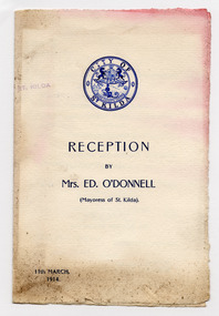
Ephemera - Concert program, Reception by Mrs Ed O'Donnell (Mayoress of St Kilda), 1914
Edward O’Donnell was elected a St. Kilda Councillor in 1888 and served for more than 40 years, including six terms as mayor. In 1872 he married Bridget Brown at St. Mary’s, East St. Kilda. They were to have eleven children.Yellowed white coloured folded paper, printed in blue with City of St Kilda logo on front and details of the program for a reception by the Mayoress of St Kilda in 1914.st kilda mayoral function, city of st kilda, hj inge, isabel beddle, mollie barrett, hector goldspink, essie taylor, kittie gleeson, di gilio's band -
 St Kilda Historical Society
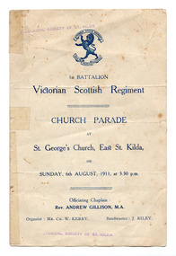
Ephemera - Program - religious service, 1st Battalion Victorian Scottish Regiment Church Parade, 1911
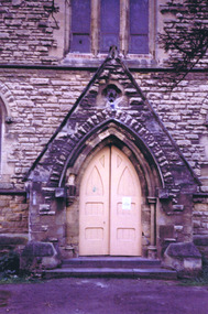
Service at St George's Church, East St Kilda, on 6 August 1911.Folded single sheet of white paper that has discoloured with age, printed in blue with Scottish Regiment insignia on the front.victorian scottish regiment, st george's presbyterian church st kilda -
 St Kilda Historical Society
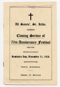
Ephemera - Program - religious service, Closing Service of 70th Anniversary Festival, 1928
Program commemorating the church's 70 year history, and Armistice Day, in 1928. All Saints Anglican Church in East St Kilda is one of Melbourne's oldest Anglican churches. The foundation stone was laid on 8 November 1858 and the first service was held in the church on the 8 December 1861. The building which can seat up to 1400 people is said to be the largest Anglican parish church in the southern hemisphere. Two sheets of yellow paper, folded and bound with two staples and printed in blackall saints church, all saints anglican church st kilda -
 St Kilda Historical Society
Ephemera - Ticket, Picnic to Park Orchards, 1936
Ticket to picnic at Park Orchards on 21 December 1936, organised by the St Kilda Unemployed Organisation with the support of the St Kilda City Council, Mayor (Cr Alfred Levy), Archie Michaelis MLA, and 'other well-known gentlemen'. The ticket appears to have been perforated to allow vouchers, printed on the back (for bus, dinner, toys, stockings, ice cream and tea) to be separated and used. Park Orchards is a residential suburb 23km north east of Melbourne that was created in 1925 on land used for orchards when timber merchants Australis Sharp and John Taylor launched the Park Orchards Country Club estate. Buyers were not attracted to the estate, and for many years all that existed were a clubhouse and various sporting facilities. It gained popularity when demand for housing surged in the 1950s.Grey/green coloured card, printed in blue on both sides and with 5 evenly spaced lines of perforations across the width.st kilda unemployed organisation, st kilda council -
 St Kilda Historical Society
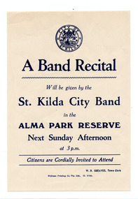
Ephemera - Poster, A Band Recital, c1970s
Notice of performance by the St Kilda City Band at Alma Park, St Kilda East on a Sunday afternoon. The date is not given.White paper, discoloured with age, printed in blue on one sidest kilda city band, alma park -
 St Kilda Historical Society
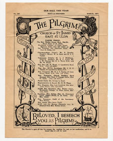
Document - Newsletter, The Pilgrim, 1957
Newsletter of the Church of St James East, St Kilda, edition no 367, published in March 1957. Contains the names of the Parish Priest and church officials; the dates and times of services, including for Lent 1957; lists of new subscribers; summaries of meetings; announcements.White paper, yellowed with age, printed in black on both sides and folded in half.the pilgrim newsletter, church of st james - east st kilda -
 St Kilda Historical Society
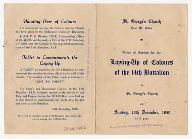
Ephemera - Program - religious service, Laying-Up of Colours of the 14th Battalion, 1950
Order of service for the laying-up of colours of the 14th Battalion in St George's Presbyterian Church St Kilda (now St George's East St Kilda Uniting Church) on 10 December 1950White card, discoloured with age, printed in blue on both sides and folded in half2/14th army battalion, 2/14th army battalion association, st george's presbyterian church st kilda -
 St Kilda Historical Society
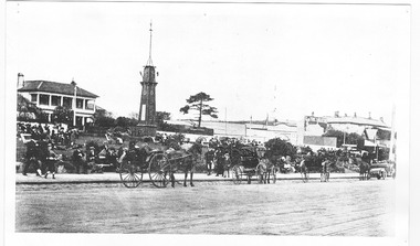
Postcard - Photograph Streetscape, Fitzroy St, St Kilda
view from south west end of Fitzroy St looking north eastblack and white photograph -
 St Kilda Historical Society
Postcard, Boer War Memorial, Alfred Square, Esplanade East, c. 1890
black and white photograph, unmounted copy, good conditionMelbourne -Suburbs St Kilda Alfred Square and Soldiers Memorial from the Esplanade. St Kilda by the Sea Annual Season 1915/16 p.107 F600:65 c1890 -
 St Kilda Historical Society
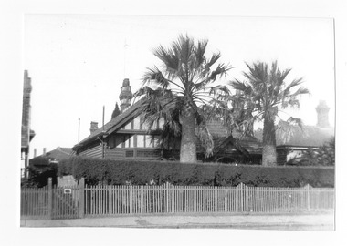
Photograph, 106 Westbury St, St Kilda, c.1931
... showing front of house from street On back: East St Kilda Vic ...photo taken in about 1931 showing front of house from street black and white photograph, unmounted, orginal, good conditionOn back: East St Kilda Vic about 1931 Residence of family Govett #118 (later 106) Westbury St -
 St Kilda Historical Society
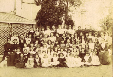
Photograph, Oberwyl, c. 1880 - 1890?
Pupils and Teachers of The Girls High School, Oberwyl, Burnett St, St Kildasepia photograph fair conidtion mountedMalson�� (Armstrong?) 1081 Hoddle st East Melbourne. Girls' high school, "Oberwyl" Burnett St, St Kilda. -
 St Kilda Historical Society
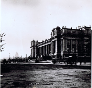
Photograph, Parliament House, c. 1900
black and white photograph fair conditionParliament House, Spring St, 1900. Briam Pump. 36 Kanaith road, Ringwood East, 3135. Phone 870 7001 -
 St Kilda Historical Society
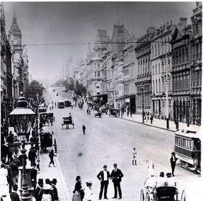
Photograph, Collins St Melbourne, c. 1897
... Collins Street, (looking east) 1897... Carlisle Street St Kilda melbourne Collins Street, (looking east ...black and white photographCollins Street, (looking east) 1897 -
 St Kilda Historical Society
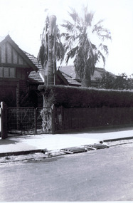
Photograph, 106 Westbury St, East St Kilda, c. 1934?
palm trees removed from front garden, gates for proposed construction of a garage in 1934black and white photographWestbury St, East St Kilda 106. Removal of Palms from Garden. Note the Gates to allow for a garage built 1934 -
 St Kilda Historical Society
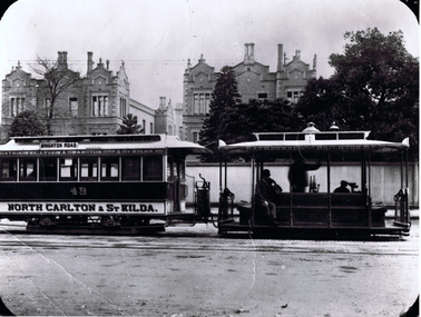
Photograph, CableTram, c. 1905
also stamped on back D.J. Taggartblack and white photograph1900. CableTram (North Carlton to St Kilda) in Lonsdale St, Melbourne about 1905. Brian Pump 36 Knaith road, Ringwood East. Phone: 8707001. Rathdowne, Lygon and Swanston sts and St Kilda rd. Rathdowne st to Brighton rd. 49 North Carlton and St Kilda.