Showing 10746 items
matching maps
-
 Koorie Heritage Trust
Book, Gibbs, R. M, The Aborigines, 1994
The book seeks to provide a readable account of traditional Aboriginal society in Australia, and of what happened to that society after the European invasion began in 1788.152 p. : ill., maps. ; 25 cm.The book seeks to provide a readable account of traditional Aboriginal society in Australia, and of what happened to that society after the European invasion began in 1788.aboriginal australians -- history. | aboriginal australians -- social life and customs. -
Koorie Heritage Trust
Booklet, Brown, John, Corinella sesqui-centenary celebrations : a brief outline of the early history of Western Port -Victoria, with particular reference to the settlement at Corinella in the year 1826, 1976
A brief outline of the early history of Western Port - Victoria with particular reference to the settlement at Corinella in the year 1826.[12] p. : ill., maps ; 22 cm.A brief outline of the early history of Western Port - Victoria with particular reference to the settlement at Corinella in the year 1826. 1. corinella (vic.)--history. i. title., 2. bunerong-western port (vic.) -
Koorie Heritage Trust
Book, Hibbins, G. M, Barmah Chronicles, 1991
This book is a collection of writings about the Barmah area and of illustrations made by some of its residents and visitors over the years.144p,; maps; figs.;index; 21 cm.This book is a collection of writings about the Barmah area and of illustrations made by some of its residents and visitors over the years.barmah (vic.) -- history. | barmah (vic.) -- history. -
Koorie Heritage Trust
Book, Brown, Rik, The upper Yarra River corridor : sites of conservation significance, 1993
179 p.; maps; appendices; 30 cm.environmental protection -- victoria -- yarra river region. floodplain management -- victoria -- yarra river region. ecology -- victoria -- yarra river region. biodiversity conservation -- victoria -- yarra river region. yarra river region (vic.) -
Whitehorse Historical Society Inc.
Article, Tour of City of Nunawading, 1968?
Notes for a tour of the City of Nunawading, with accompanying map.Notes for a tour of the City of Nunawading, with accompanying map.Notes for a tour of the City of Nunawading, with accompanying map.city of nunawading, map -
Whitehorse Historical Society Inc.
Map, Community facilities, 1/10/1981 12:00:00 AM
Map of the City of Nunawading showing community facilitiesMap of the City of Nunawading showing community facilitiesMap of the City of Nunawading showing community facilitiesparks and reserves, city of nunawading, schools, senior citizens centres, maternal and child health centres, post offices, police stations, preschools -
Whitehorse Historical Society Inc.
Map, Eastern Freeway, n.d
Map of proposed Eastern Freeway, Mitcham - Ringwood.Map of proposed Eastern Freeway, Mitcham - Ringwood.Map of proposed Eastern Freeway, Mitcham - Ringwood.freeways, eastern freeway, mullum mullum creek -
Whitehorse Historical Society Inc.
Document, Mitcham Township 1914 - 1917, n.d
Hand drawn map of Mitcham township c1914.Hand drawn map of Mitcham township c1914.Hand drawn map of Mitcham township c1914.boxshall, hilda, mitcham -
 Whitehorse Historical Society Inc.
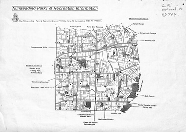
Map, Nunawading parks and recreation information, 1990 ?
Map of parks and reserves in the City of Nunawading, 199-?city of nunawading. parks and recreation department, parks and reserves -
 Ringwood RSL Sub-Branch
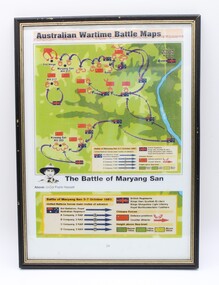
Map
australian wartime battle maps rectangular frame, the battle of maryang san, -
 Ballarat Heritage Services
Map, Central Europe and the Mediterranean during World War One
Map of the World as it was during World War One. map of the world, world war one, france, spain, england, ireland, germany, austria-hungary, rumania, servia, albania, greece, bulgaria, russia, asia minor, turkey, egypt, tripoli, morocco, algeria, tunis -
 Queenscliffe Maritime Museum
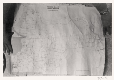
Map - French Island, County of Mornington, French Island map photographs x 2, c1987
Islands off Victorian coastFrench Island mapFrench Island map photographs x 2Reverse " Nil "french island -
Running Rabbits Military Museum operated by the Upwey Belgrave RSL Sub Branch
Pilot's Map
Part of survival KitMap of Japan, East & South China Seas.equipment, ww2, raaf -
Running Rabbits Military Museum operated by the Upwey Belgrave RSL Sub Branch
Pilot's Map
Part of Survival Kit.Map of North Borneo and surrounds and East Javaequipment, ww2, raaf -
 Running Rabbits Military Museum operated by the Upwey Belgrave RSL Sub Branch
Photo
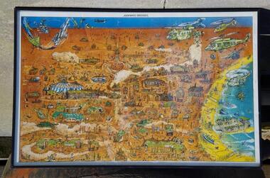
Cartoon depiction of Kakatoo 2 Exercise map.picture, c2000, army -
![Book, The Northcote Side of the River / [by] Andrew Lemon, 1983](/media/collectors/550653872162f11fb04854aa/items/5d034cac21ea7b09505990ad/item-media/5d034cca21ea7b095059b2fd/item-fit-380x285.jpg) Kew Historical Society Inc
Kew Historical Society IncBook, The Northcote Side of the River / [by] Andrew Lemon, 1983
306 p. : ill., facsims., maps, portsnorthcote (vic) - history -
Hand Tool Preservation Association of Australia Inc
Map
This item is part of the Thomas Caine Tool Collection, owned by The National Trust of Australia (Victoria) and curated by the Hand Tools Preservation Association of Australia.Map of essendon, moonee ponds, ascot vale -
Stawell Historical Society Inc
Map, Tourist Map of Grampians/Halls Gap and Surrounds, 1928
Tourist Map of Grampians/Halls Gap and Surroundsstawell, tourism -
Stawell Historical Society Inc
Document - Photo Map, 1953
Photo Map. Glenorchy A1, Zone 6.stawell -
Stawell Historical Society Inc
Document - Photo Map, 1953
Photo Map. Glenorchy A2, Zone 6.stawell -
Stawell Historical Society Inc
Document - Photo Map, 1953
Photo Map. Glenorchy A3, Zone 6.stawell -
Stawell Historical Society Inc
Document - Photo Map, 1953
Photo Map. Glenorchy A4, Zone 6.stawell -
Stawell Historical Society Inc
Document - Photo Map, 1953
Photo Map. Glenorchy B1, Zone 6.stawell -
Stawell Historical Society Inc
Document - Photo Map, 1953
Photo Map. Glenorchy B2, Zone 6.stawell -
Stawell Historical Society Inc
Document - Photo Map, 1953
Photo Map. Glenorchy B3, Zone 6.stawell -
Stawell Historical Society Inc
Document - Photo Map, 1953
Photo Map. Glenorchy B4, Zone 6.stawell -
Stawell Historical Society Inc
Document - Photo Map, 1953
Photo Map. Glenorchy C1, Zone 6.stawell -
Stawell Historical Society Inc
Document - Photo Map, 1954
Photo Map. Glenorchy C2, Zone 6.stawell -
Stawell Historical Society Inc
Document - Photo Map, 1954
Photo Map. Glenorchy C3, Zone 6.stawell -
Stawell Historical Society Inc
Document - Photo Map, 1954
Photo Map. Glenorchy C4, Zone 6.stawell