Showing 22335 items
matching parks
-
 Whitehorse Historical Society Inc.
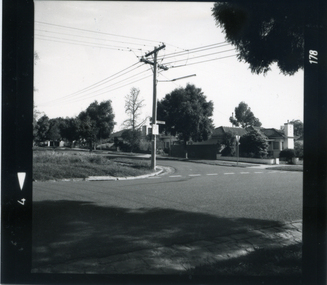
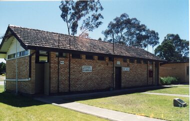
Photograph, Corner Victoria & Edward Streets, Mitcham, c 1987
Photograph taken prior to the building of the Coles supermarket and car parkBlack and white photograph of the corner of Victoria and Edwards Streets, Mitcham; looking south and west c. 1987victoria street, mitcham, edward street -
 Stawell Historical Society Inc
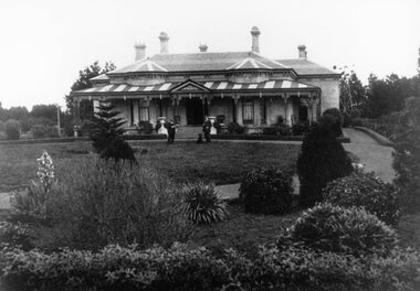
Photograph, “Yarram Park” Homestead in Willaura owned by the Simmons Family
“Yarram Park” Homestead Willaura owned by the Simmons Family of OBANwillaura simmons -
 Stawell Historical Society Inc
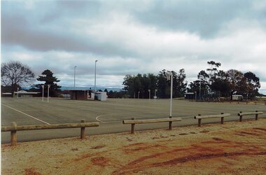
Photograph, North Park looking from Lamont Sttreet with the Netball Courts to the left
North Park Lamont St. Netball Courts to left in entrystawell sport -
 Stawell Historical Society Inc
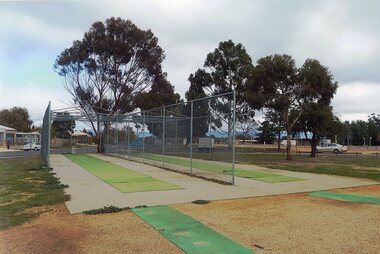
Photograph, North Park looninfg from Lamont Street with the Cricket Nets to the right
North Park Lamont St. Cricket Nets to right in entrystawell sport -
 Stawell Historical Society Inc
Photograph, Grampians Gate Caravan Park -- Improved Facilities 1977
Grampians Gate Caravan Park 1977 Facilities were improvedstawell -
 Stawell Historical Society Inc
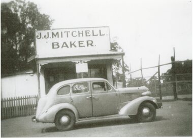
Photograph, J J Mitchell Baker's Shop in Glenorchy with a Sedan parked outside
Mitchell J.J. Glenorchy. Baker Sedan parked outside shop.stawell -
 Stawell Historical Society Inc
Photograph, Stawell Girl Guides Activities at Bastin Park --- Opposite Lake Fyans -- 2 Photos
Bastin Park - Guides. Opposite Lake Fyans Two photographs stawell -
 Stawell Historical Society Inc
Photograph, Central Park Gardens & the Sundial Stawell
Valentine's Postcard. V1. The Gardens and Sundial Central Park Stawellstawell -
 Stawell Historical Society Inc
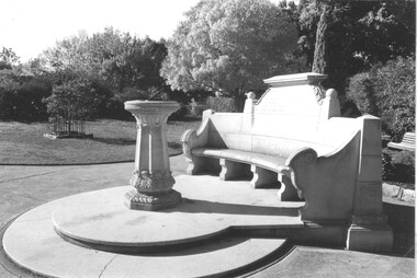
Photograph, Close up view of the Memorial Seat & Sundial at Central Park Stawell
Close up view of Seat and Sundial at Central Park Stawellstawell -
 Stawell Historical Society Inc
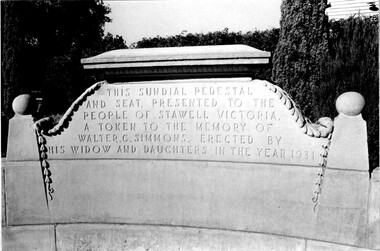
Photograph, Close up view of the Inscription on the Memorial Seat at Central Park Stawell
Close up view of Inscription on Seat at Central Park Stawellstawell -
 Stawell Historical Society Inc
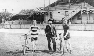
Photograph, Messrs. Chapman, Neal & Ledger -- Cyclists At Central Park 1905
Cyclists At Central Park. Messrs. Chapman. Neal & Ledger 1905stawell -
 Wonga Park Community Cottage History Group
Photograph (Item) - Black and White, Wonga Park: The Oaks 3 in garden
Wonga Park: The Oaks 3 in garden and lady in front of housePhoto is named 14880029.jpg on CD -
 Stawell Historical Society Inc
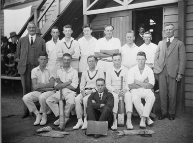
Photograph, Stawell Cricket Team at Central Park 1928
Stawell Cricket Team played Hamilton at Central Park 1928stawell sport -
 Eltham District Historical Society Inc
Slide, Construction of Eltham Town Park, 22 Feb 1974
Construction of Eltham Town Park, later renamed Alistair Knox Park. In the distance can be seen the Eltham Tip accessed from Susan Street and the Shell Service Station which was situated on the corner of Susan Street and Bridge Street, now the site of Bunnings35 mm colour positive transparency Mount - Agfacolor Service (Blue)alistair knox park, eltham town park, eltham tip, shell service station, susan street -
![Advertising Leaflet, Grace Park Electric Station Estate, Watsonia [3], 21/06/1924](/media/collectors/4f729f5697f83e03086015b8/items/5dcfb9c821ea671434edd447/item-media/5dcfb9e821ea671434ededfc/item-fit-380x285.jpg) Greensborough Historical Society
Greensborough Historical SocietyAdvertising Leaflet, Grace Park Electric Station Estate, Watsonia [3], 21/06/1924
Digital copy of auction leaflet for sale of land known as Grace Park Electric Station Estate, Saturday 21/06/1924. Auctioneer Knight & Harwood in conjunction with C. Jessop. This leaflet shows a photograph of the 'Grace Park Railway Station' nearing completion.Digital copy of auction leaflet 1 page. Black and red text on white paper.watsonia, grace park -
 Hepburn Shire Council Art and Heritage Collection
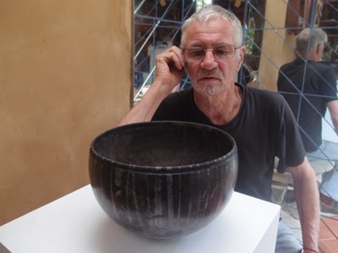
Public Art Work, Petrus Spronk, 'Silent/Listen Listen/Silent' - Petrus Spronk. 2001, 2001
This work was first commissioned by the Melbourne city council as part of a celebration of the opening of the Birrarung Marr park. 25 victorian sculptors were given $2,500.00 to create a work which would be part of the park for about 6 months. Date of manufacture and installation: 2002 'Silent/Listen' was gifted by the artist, Petrus Spronk, to the people of Hepburn Springs in July 2001.Two smooth rectangular engraved granite slabs placed directly on the ground. Each granite stone is engraved on its uppermost surface. The left hand work is engraved with the text - 'silent' and the right hand work is engraved with 'listen'. Unsigned. Dated July 2001 petrus spronk, public art, sculpture, environmental art, hepburn shire public art collection, hepburn shire, listen, silent, hepburn springs mineral reserve, granite -
Clunes Museum
Document, MINUTES FOR PUBLIC MEETING HELD IN THE TOWN HALL CLUNES ON 23/2/1971, 23/02/1971
THIS PUBLIC MEETING WAS TO CONSIDER THE FOLLOWING; HOLDING OF A "BACK TO CLUNES", CONSTRUCTION OF A CARAVAN PARK AND CONSTRUCTION OF A SCENIC TOURISE ROAD FROM ANGUS STREET TO FRASER STREET VIA "THE ROCKS" THIS RESULTED IN THE ELECTION OF A "BACK TO CLUNES" COMMITTEE AND THE" SCENIC ROAD AND CARAVAN PARK COMMITTEE".2 X FOOLSCAP PAGES OF THE COPY OF MINUTES HELD IN THE TOWN HALL, CLUNES ON 23/2/1971local history, local government, council, events and celebrations, back to clunes, scenic road and caravan park committee -
Port Melbourne Historical & Preservation Society
Pamphlet - The Pubs of Port 2001, Pat Grainger, Walks around Vintage Port No.6, 2001
Update and reprint of Pubs in Port Walk (No 7). Project Assisted by CoPP. The original Pubs in Port Walk was No 7 with No 6 reserved for Bend on the River: Westgate Park. The Westgate Park walk was not produced so on this updated version the Pub walk became No 6.Port Melbourne Historical and Preservation Society publication, "Walks around Vintage Port", "No.6 Pubs of Port" 2001 Edition.built environment - commercial, business and traders - hotels -
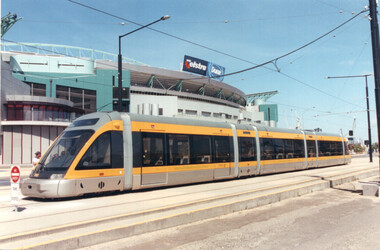 Melbourne Tram Museum
Photograph - Colour print - Porto Portugal Euro Tram 018 - Docklands, Jan. 2003
Colour print showing Porto Portugal Euro Tram No 018 parked in the Docklands Harbour Esplanade tracks - January 2003 with the Telstra Dome (Stadium) in the background. Tram parked on the middle track at this location at the time. Tracks in the area have since been relocated. Yields information about the tram from Porto that visited Melbourne Jan. 2003Colour print on paper - Kodak Professional Papertrams, tramways, harbour esplanade, docklands melbourne, eurotram, tram 018, porto, telstra dome -
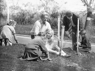 Eltham District Historical Society Inc
Photograph, ELTHAM ARBOR DAY 1973 - Alistair Knox with school children of the Shire of Eltham, Vic, planting native trees in the Town Park, 10 October 1973, 1973-10-10
Eltham Arbor Day, 10 October, 1973. School children of the Shire of Eltham planting trees with Alistair Knox in Eltham Town Park. Knox was a local architect and conservationist and councillor for the Shire of Eltham 1972-1975. The day was previously planned to take place during the visit of the Governor, Sir Rohan Delacombe to the Shire on 19th September, 1973 but cancelled that day due to inclement weather. Eltham Town Park would later be renamed Alistair Knox Park. This photo forms part of a collection of photographs gathered by the Shire of Eltham for their centenary project book," Pioneers and Painters: 100 years of the Shire of Eltham" by Alan Marshall (1971). The collection of over 500 images is held in partnership between Eltham District Historical Society and Yarra Plenty Regional Library (Eltham Library) and is now formally known as 'The Shire of Eltham Pioneers Photograph Collection.' It is significant in being the first community sourced collection representing the places and people of the Shire's first one hundred years.Black and white photograph print 16.5 x 21.5 cmtree planting, arbor day, alistair knox, eltham town park, alistair knox park, sepp, shire of eltham pioneers photograph collection, school children -
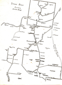 Wonga Park Community Cottage History Group
Plan (sub-item) - Plan re moving State School to corner of Yarra and Brysons Roads
A plan prepared by Mr. A.J. Upton (secretary and convenor of the Wonga Park School Committee) in about 1920, when residents were pressing for a new school to be located at the junction of Bryson’s and Yarra Road, the object being to combine the Wonga Park and Yarra Road Schools. Although the proposal was eventually dropped, this plan shows who lived in Wonga Park in the 1920’s and where they lived. [It is likely that this plan dates from some time after 1920.]wonga park school -
 Bendigo Historical Society Inc.
Document - Hustlers, Sheepshead and Deborah lines of reef
Albert Richardson was a mining historian who wrote widely on the mines of the Bendigo Goldfield. The park opposite the Goldmines Hotel in Marong Road, is named in his honour. Five page document, hand written by Albert Richardson on lined foolscap and edited with cross-outs and insertions, . The mines along the Hustlers line of reef and the Sheepshead line of reef are described. Mines listed on Hustlers line of reef: Fortuna Hustlers (1888 - 1913), shaft 2,240 feet at rear of Buckell and Jeffrey's offices; Royal Hustlers Reserve No. 2 - two shafts 'City" 860 feet, now covered by R.S.L. building Pall Mall, steel poppet legs 60 ft high and 'Park Shaft" at rear of Camp Hill School, 1,775 feet, steel poppet legs 60 feet high; Hustlers Hill Group first worked by Jonathan Harris in 1853 and bounded by Valentine, Anderson and Ironbark Creek to the north and Milroy Street to the east, one of first areas worked for quartz reefing. It with Garden Gully line west and Victoria Hill Ironbark, formed by far the richest cross section of the Bendigo Goldfield. Great Extended Hustlers (1865-1921) close to intersection of Anderson Street and Hustlers Road, mullock heap against road and shored up around shaft, steel poppet legs now at Wattle Gully mine, Chewton, large winding machine, air compressor south of shaft and 36 head crushing battery. Hustlers Reef (Old Hustlers) and Hustlers Reef No. 1, two shafts, main 2,210 feet, about 220 yards east of Moran Street and against Fenton Street. , No. 1 shaft 1,140 feet and about 155 yards east of Moran Street. Lansell's Comet, Lightining Hill line, 2.100 feet, on Comet Hill approx 70 yards west of Holmes Road, near Comet Creek, steel poppet legs. United Hustlers and Redan (1876-1918), main Redan, 1,830 feet about 155 yards west of Sandhurst Roead, in line with Comet Hill State School, this hill known as Redan Hill. North, or New Hustlers, once known as Agnew Hustlers, wooden poppet legs, south side, Kneebone Street, Eaglehawk. Derby line, Johnson's No. 3, South Johnson's (east shaft of Collman and Tacchi) 439 feet on west wide of Woods Street, south of Wetherall Street. Paddy's Gully Line, south to north, some shafts - Lansell's 'Sandhurst" ('Needle") Eaglehawk Road shaft 2,425 feet, about 50 yards east of Needle Loops, a brick square sided chimney with Cleopatra Needle top. British American, 789 feet, just south of Holdsworth Road. Collman and Tacchi, main shaft 2,588 feet, 60 yards west of Eaglehawk Road, California Gully. Deborah Line of Reef, The Deborah (1932-1954) shaft 2.017 feet, west of Adams Road and south of Abel Street, Quarry Hill. North Deborah (1937 - 1954) shaft 1,151 feet, Breen Street, Quarry Hill, steel poppet legs. Central Deborah (1939-1954) shaft 1,347 feet Sheepshead line of reef, Lansell's South Red, White and Blue, shaft 2,124 feet, north east of Bellevue Road and 220 yards east of Adams Road. The New Red, White and Blue Consolidated (Big Blue) main shaft 2,416 feet. Lansell's Bendigo Battery 105 head, north of 'Big Blue" on his freehold lease, commenced crushing on 24th February 1895. After closing was erected as the Showground's Industrial Hall, July 1926. North Red, White and Blue, burnt down February 1926, new company 1934, closed 1938. Document is part of the Albert Richardson Collection of Bendigo mining history. bendigo, gold mining, deborah line of reef, sheepshead line of reef, hustlers line of reef, royal hustlers reserve mine, hustlers hill group of mines, great extended hustlers, hustlers reef no. 1, lightning hill line, old comet, collman and tacchi, lansell's comet, north deborah, central deborah, dhrrpdhrsf linr og trrg, new red, white and blue consolidated mine, big blue, lansell's bendigo battery, north red, white and blue mine, albert richardson collection -
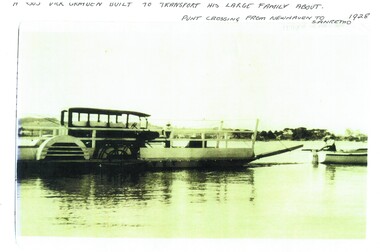 Phillip Island and District Historical Society Inc.
Photograph, Newhaven punt and Nobbies tea house, 1928, 1929
Historical4 A4 photocopies of black & white photos. A large bus on a punt with a person onboard. A small boat with 2 men towing the punt. Land in the background. Wooden building with a group of 6 people standing outside, one looking through telescope.with sloping roof and sign Ye Olde Tea House. Set on barren headland, sea in background with 2 small outbuildngs and a car parked beside building. Other photos show group of cars parked near the same building or on barren headland.A bus Dick Grayden built to transport his large family about 1928. Punt crossing from Newhaven to San Remo. Original tea house at Nobbies. 1929phillip island punt, richard grayden, the nobbies kiosk, point grant, motor car -
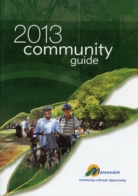 Ringwood and District Historical Society
Book, Community Guide 2013 Maroondah City Council, Ringwood Victoria
Community information book issued by City of Maroondah for 2013 covering the facilities and activities of the Ringwood Council and other local organisations and associations. Includes contact details for Council services, community organisations and emergency services. Supplement - Maroondah In Focus newsletter Sept to Nov 2013 includes features Sherbrook Park, Ringwood Library developments, Staley Gardens makeover, Costco opening preparations, Eastland transformation works with QIC Global Real Estate, Railway Station and bus interchange tenders, Ringwood Lake Park improvements. -
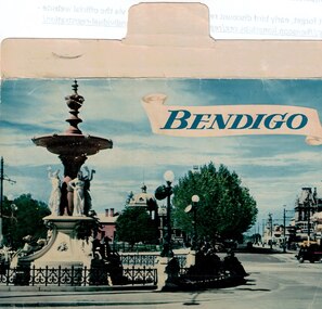 Bendigo Historical Society Inc.
Souvenir - Bendigo Fold-out Postcards, Early 1950s
BHS CollectionCarol Holsworth Collection: Bendigo Fold-out Postcards - 13 Photos of Alexandra Fountain, Botanical Gardens, Conservatory Gardens, Rosalind Park Lookout, Rosalind Park Sound Shell, View from the Lookout, Queen Victoria Gardens, Lake Weroona, the town hall, Charing Cross, the Post Office and Law Courts, Pall Mall and the Sacred Heart Cathedral. On the rear, it is addressed to Mr. R J Randall, c/o A.N.Z. Ltd, Fish Creek, Victoria. Published by Nucolorvue Productions, Mentone, Victoria. history, bendigo, carol holsworth collection, postcard -
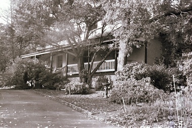 Southern Sherbrooke Historical Society Inc.
Photograph, Visit to Mt Heatherly, early 2000s
Photos of Mt Heatherly, an historical building in Belgrave, opposite Belgrave Lake Park. Address is Park Drive, on the corner of Waratah Ave. The house is now owned by Mrs Elizabeth Schneider, and was first constructed around 1881 by the first owner of the selection, Ormond Smith. It was made of hand-made bricks made on site, and a foundation of rock and stone. The original house may have had a corrugated iron roof. The original house forms part of the modern house. Photos taken in early 2000s by Susan Heywood-Downard. -
 Southern Sherbrooke Historical Society Inc.
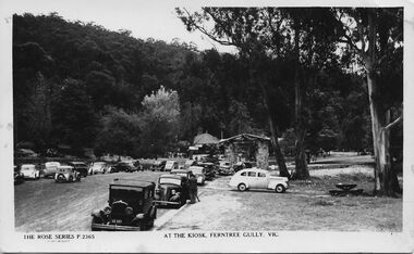
Postcard - At The Kiosk, Ferntree Gully, Vic
B&W postcard, Rose Series P.2365, named 'At The Kiosk, Ferntree Gully, Vic.' Photo shows around twenty or more cars parked outside the kiosk in what is now Ferntree Gully National Park Several people are walking and standing in the carpark and on the paths. The kiosk is visible in the background with advertising signs outside, including one for Peters Ice-cream. Closer to the camera is a stone shelter. There are tall trees beside the carpark and in the background of the photo is a heavily treed hillside. The back of the postcard is blank. -
 Ballarat Tramway Museum
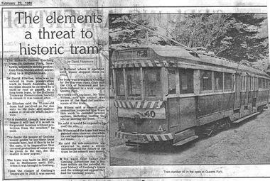
Document - Photocopy, The Courier Ballarat, "The elements a threat to historic tram", 23/02/1985 12:00:00 AM
Photocopy of an article concerning the fate of a Ballarat tram after its return to Geelong and storage in open weather. The tram was in poor condition. BTPS did inspect but did not have the room to store and its poor condition went against recovery. Subsequently acquired by the TMSV and since sold?Photocopy of an article on an A4 sheet from the Geelong Advertiser dated 23-2-1985, titled "The elements a threat to historic tram". Article by David Fitzsimons about the poor condition of the body of Geelong tram No. 40 in Queens Park Newtown. Gives a short history of the tram, including its time in Ballarat as No. 43. Quotes Dr. David Ellerton who reported on the situation, Mr Tom Wilson, City Engineer of Newtown. Has a photo of the tram in Queens Park. Mentions offering the tram to the BTPS.trams, tramways, geelong, queens park, newtown, sale of trams, scrapped trams -
Kew Historical Society Inc
Archive (series) - Subject File, Kew Historical Society, JELLIS, Thomas G, 1958
Various partiesReference, Research, InformationSecondary Values (KHS Imposed Order)Subject file containing research and primary sources relating to T.G. Jellis and his family bakery in High Street, and later Studley Park Road, Kew. It includes a 1-page summary compiled by Elizabeth Mackie of an interview with his daughter Mrs Whitney, which was separately recorded on tape. A later document is a reminiscence of the bakery in Studley Park Road by Trevor D. Fiander of Ballan. This document includes drawings of the exterior and interior. [An article on the bakery can also be accessed in KHS Newsletter No.104 September 2013.kew historical society - archives, kew - history, t.g. jellis, mayors of kew - t.g. jellis, bakeries - kew (vic), mrs whitney (1895-?), trevor fianderkew historical society - archives, kew - history, t.g. jellis, mayors of kew - t.g. jellis, bakeries - kew (vic), mrs whitney (1895-?), trevor fiander -
Kew Historical Society Inc
Plan - Willsmere Park Estate, Kew, 1926
Subdivision plans and real estate flyers/brochures reveal a number of aspects of urban development and history. The Kew Historical Society's collection of these plans, as well as advertisements extracted from magazines, cover key aspects of community development and architectural history of Kew and Kew Eat as well as surrounding suburbs. While most of the plans in the collection were gifted to the Society by the former City of Kew, a number of other plans and advertisements have been donated by individuals, of which this is an example.Original 4-page, bifold subdivision plan of the Willsmere Park Estate, Kew. The 1926 land sale advertised '40 superb villa allotments' on the 'Yarra Heights'. Streets within the subdivision included: Willow Grove, Kilby Road, Elm Grove and Belford Road. The double page spread on pages 2 and 3 shows the detailed plan of the 40 lots, surrounded by public parkland [Willsmere Park] and the Kew Golf Links. By the time that this version of the plan was released, only the lots on Willow Grove and Kilby Road remained. willsmere park estate -- kew (vic.), subdivisions - kew (vic.), subdivisions -- kew east (vic.), willsmere park -- kew east (vic.)