Showing 3154 items
matching police
-
 Wodonga & District Historical Society Inc
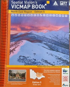
Book - Spatial Vision's VICMAP BOOK 2016 - Northeast Region, Spatial Vision Innovations Pty Ltd, 2016
This edition of Spatial Vision's VicMap Book North East Region was published in October 2016 and provides detailed topographic maps for the region. It was used by emergency services and various agencies, including the Country Fire Authority (CFA). It covers areas including Wodonga, Albury, Wangaratta, and beyond, including national parks and recreation areas. Text on the cover states that the volume is "Trusted by and produced in partnership with: Department of Environment, Land, Water & Planning, Country Fire Authority, State Emergency Service, Parks Victoria, Victoria Police".A spiral bound volume of 409 pages including colour topographic maps and illustrations of North East Victoria. The cover features a colour photo of Razorback Ridge leading to Mount Feathertop, Hotham Heights, Victoria. It also features an index map inside the front cover, a legend, road index, and locality index.This edition of Spatial Vision's VicMap Book North East Region was published in October 2016 and provides detailed topographic maps for the region. It was used by emergency services and various agencies, including the Country Fire Authority (CFA). It covers areas including Wodonga, Albury, Wangaratta, and beyond, including national parks and recreation areas. Text on the cover states that the volume is "Trusted by and produced in partnership with: Department of Environment, Land, Water & Planning, Country Fire Authority, State Emergency Service, Parks Victoria, Victoria Police".emergency management north east victoria, state emergency service, cfa wodonga -
 Wodonga & District Historical Society Inc
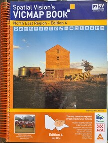
Book - Spatial Vision's VICMAP BOOK 2014 - North East Region
This edition of Spatial Vision's VicMap Book North East Region was published in May 2014 and provides detailed topographic maps for the region. It was used by emergency services and various agencies, including the Country Fire Authority (CFA). It covers areas including Wodonga, Albury, Wangaratta, and beyond, including national parks and recreation areas. Text on the cover states that the volume is "Trusted by and produced in partnership with: Department of Environment, Land, Water & Planning, Country Fire Authority, State Emergency Service, Parks Victoria, Victoria Police".A spiral bound volume of 409 pages including colour topographic maps and illustrations of North East Victoria. The cover features a colour photo of the old flour mill at Milawa, Victoria. It also features an index map inside the front cover, a legend, road index, and locality index.non-fictionThis edition of Spatial Vision's VicMap Book North East Region was published in May 2014 and provides detailed topographic maps for the region. It was used by emergency services and various agencies, including the Country Fire Authority (CFA). It covers areas including Wodonga, Albury, Wangaratta, and beyond, including national parks and recreation areas. Text on the cover states that the volume is "Trusted by and produced in partnership with: Department of Environment, Land, Water & Planning, Country Fire Authority, State Emergency Service, Parks Victoria, Victoria Police".emergency management north east victoria, cfa wodonga -
 Wooragee Landcare Group
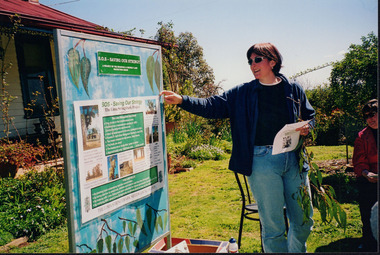
Photograph, 5 September 2004
Wooragee Landcare Group took a bus trip Sunday 5th September to Samaria, Tatong area (near Benalla) to look at land use on small farms. Around this time, Wooragee Landcare were looking into how small land holders could run some enterprises. This photo was taken at Tatong Tavern where the group had lunch. The Tatong Tavern is an old English style pub situated in the foothills of the Great Dividing Range the small community of Tatong 23km south-east of Benalla. The original weatherboard hotel was originally built in the 1880s by William Worrall who was listed as Hotel Keeper from 1886 to 1910. It was destroyed by fire in 1923 and replaced by the current building, which has undergone many changes over the past 100 years. The name has also changed from the Tatong Hotel or ‘Pub’ to the current name of Tatong Tavern.Tatong is a rural village in north-east Victoria, set in undulating country that rises southwards to the Tolmie ranges. The name is thought to derive from an Aboriginal expression, possibly referring to something unseen. The Tatong pastoral run was taken up in 1847 and farm selections began in the 1870s. A school opened in 1890 (closed in 2006). Dairy herds were grazed on the Tatong flats and a cooperative creamery operated from 1892 until 1918. In 1914 a branch railway line was opened from Benalla to Tatong that carried farm produce and timber to Tatong, which had two sawmills in the 1920s. There was also a general store, a police station, and a livestock trucking yard. St Albans Church of England was built in 1921. Most of those buildings have now disappeared. The Tatong Tavern along with the Hall built in 1904 are the only remaining buildings. The Tatong Tavern is a significant tangible and visual representation of the area’s cultural and social history over the past 100 years. Coloured rectangular photograph printed on paperReverse: WAN NA E0NA2N2. NNN- 14240/ (No. 20) 373/ tatong, tatong pub, tatong tavern, tolmie ranges, tatong flats, benalla, wooragee landcare, wooragee landcare group, bus trip, samaria, land use, william worrall, 1800s, 2004, mount samaria -
 Narre Warren and District Family History Group
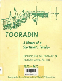
Book, DJ Mickle, Tooradin - A History of a Sportman's Paradise, 1975
Lots of information on the various sporting groups like Football, Netball, Rifle club, schools, honor rolls and pioneer families96 p.; 23 cmnon-fictionLots of information on the various sporting groups like Football, Netball, Rifle club, schools, honor rolls and pioneer familiesstudents from 1928 - 1974., tooradin primary school number 1503, tooradin police