Showing 9725 items
matching west
-
 Glenelg Shire Council Cultural Collection
Photograph - Photograph - oil tanks, n.d
Port of Portland Authority ArchivesBack: 2398 Lines drawn in biro 5 3/4" 4 1/8" 8036 s/s in pencilport of portland archives, oil tanks -
Glenelg Shire Council Cultural Collection
Photograph - Photograph - oil tanks, n.d
Port of Portland Authority Archivesport of portland archives, fishermans breakwater -
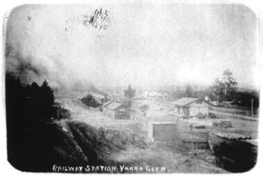 Yarra Glen & District Historical Society
Sepia postcards, Railway Station Yarra Glen
Faded sepia photograph of the Yarra Glen Railway Station taken from a point south west of the buildings. In the centre of the photograph is the railway station and platform. To the right is a goods shed. In the background is 'River View'.On the back at the top "POST CARD". Below that is "FOR CORRESPONDENCE" to the left and "FOR ADDRESS ONLY" to the right. Centre right is a stamp "YARRA GLEN/Mrs. E. Smith/SYMONDS STREET/YARRA GLEN 3775"yarra glen, river view, yarra glen railway station, railway station, railway platform, goods shed -
 Ringwood and District Historical Society
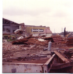
Photograph, Former Ringwood Timer and Trading Co Demolition c1979 and subsequent photos of site
Set of colour photographs taken by Richard Carter, c1979 - Ringwood Timber and Trading Co demolition, and later photos (undated) of the RT&T yard , Charer Street, looking North East and West. -
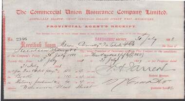 Bendigo Historical Society Inc.
Document - CONNELLY, TATCHELL, DUNLOP COLLECTION: COMMERCIAL UNION ASSURANCE COMPANY LTD
Document: Provincial Agent's Receipt for 350 Pounds from Commercial Union Assurance Company Ltd. 80 Collins St West Melbourne , for Connelly and Tatchell, fire insurance 30th. July 1888.business, legal, connelly & tatchell, connelly & tatchell, insurance -
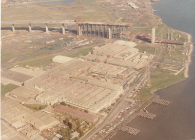 Port Melbourne Historical & Preservation Society
Photograph - Aerial view of West Gate Bridge under construction, 1960 - 1979
Colour aerial (faded) photograph of West Gate Bridge under construction with two land spans incomplete. "Rotten Row" (disused old piers) in the foreground. Aircraft factory and other industry in foreground."Master Copy . Not to be removed from Marketing department " lightly stamped on photo. and on reartransport, engineering, engineering - bridges, fishermans bend, industry, west gate bridge, rotten row, williamstown, yarra river -
Port Melbourne Historical & Preservation Society
Photograph - Photograph -Centenary Bridge stairway, Port Melbourne, 1991
Taken by Alison Kelly during the demolition years for 'Bayside' developmentColour photograph of Centenary Bridge stairway (west, beach side) through the gap under the bridge can be seen what remains of the Port Melbourne railway shunting yard. Mounted on grey paper.centenary bridge, built environment - civic, transport, alison kelly -
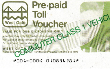 Port Melbourne Historical & Preservation Society
Document - Pre-paid Toll Vouchers for West Gate Bridge, 1980
From the collection of Warren DOUBLEDAY. Bridge tolls were imposed from its opening in 1978 until they were removed in 1985.Two unused white Pre-paid Toll Vouchers.' Commuter Class 1 Vehicle Only' is written in green across both the front and back, The West Gate logo is in the top left corner.transport - motor vehicles, built environment - west gate bridge, transport - roads -
Port Melbourne Historical & Preservation Society
Photograph - Cruise ship, Fairstar, at Outer West Station Pier, Port Melbourne, 5 Nov 1990
Colour photograph of cruise ship Fairstar (bow only) laying at Outer West Station Pier. To the left in the background athe two lead beacons can be seen. Mounted in photocorners on white card.transport - shipping, fairstar, alison kelly -
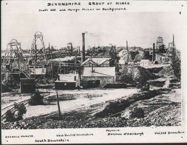 Bendigo Historical Society Inc.
Photograph - HARRY BIGGS COLLECTION: DEVONSHIRE GROUP OF MINES, Circa 1880's
Photograph of the Devonshire group of mines with Snobs Hill and Mungo mines in the background. The mines are individually labelled; Duchess Tribute, West United Devonshire, Phoenix, Duchess of Edinburgh, United Devonshire and south Devonshireplace, mining site, devon shire group, devonshire mines, snobs hill, mungo mines, united devonshire, phoenix, duchess of edinburgh, west united devonshire, south devonshire -
 Geelong Cycling Club
Minutes, Books, 1911 - 1968
Minute books of the GWCC dating from 1911 - 1968Provides details of the club's activities and persons connected with the club in the years 1911-1968.Six handwritten minute books of the Geelong West Cycling Club dated from 16/11/1911 - 13/2/1968. Each book has a hard cover and is bound along the spine.geelong cycling club; geelong west cycling club; minute books; 1911; 1968; -
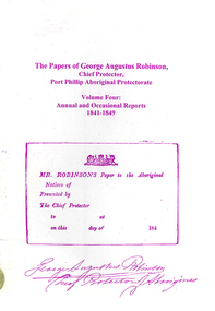 Victorian Aboriginal Corporation for Languages
Book, Ian D Clark, The papers of George Augustus Robinson, Chief Protector, Port Phillip Aboriginal Protectorate : volume four : annual and occasional reports : 1841-1849, 2001
This is a collection of Official Reports from the Chief Protector of Aborigines. It includes expedition reports to the Western Interior, 1841, a journey of 1,100 miles to the tribes of the North West and Western Interior, 1845 and Annual Reports.document reproductionsport phillip protectorate, george augustus robinson, western district, noorat, lake boloke, lake bolac, lake corangemite, portland, koroit, koonong wootong, burrumbeep, tarecurrumbeet, wimmera, lake hindmarsh, rivoli bay, mount gambier, murray river, swan hill, goulburn, loddon, mount rouse -
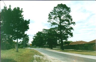 Hume City Civic Collection
Photograph, Early 1980's
A coloured photograph of Cornish Street, looking west taken from Horne Street, with an avenue of pine trees on either side of the road. There is a roundabout at the first intersection and Mt. Holden can be seen in the distance.cornish street, horne street, mt. holden, george evans collection -
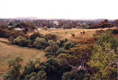 Hume City Civic Collection
Photograph, c 1980s
The photograph although recently taken shows the original settled area in Sunbury, which included Goonawarra Vineyard and Macedon Street which was once the business centre of Sunbury township before the railway was established.A coloured photograph of Sunbury Township looking west from above Jacksons Creek and Goonawarra Winery. Macedon Street can be seen in the middle distance and Mt. Holden and Burke Hill are across the skyline.sunbury township, mt. holden, burke hill, francis, james goodall, barnier, john, jacksons creek, goonawarra winery, george evans collection -
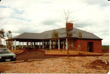 Hume City Civic Collection
Photograph, 1/10/1978
On 4th August 1978 the construction of the Goonawarra Housing Estate commenced. The estate was formerly known as the Goonawarra Farm and overloked the Sunbury town area and Jacksons Creek valley. Plans for the new development included a gold course, housing, community and recreational facilities. The construction continued througout the last two decades of the twentieth century and into the twenty first century.A coloured photograph of the clubhouse taken from the south west at the Goonawarra Golf Club. The surrounding garden has been planted out with trees and has been mulched. A green car is on the LHS of the photograph.goonawarra farm, goonawarra golf club, goonawarra housing estate, sharkey, robert b., kilkenny homes, australian ideas homes pty.ltd., craftsmen homes., glamor homes, villa bella homes, george evans collection -
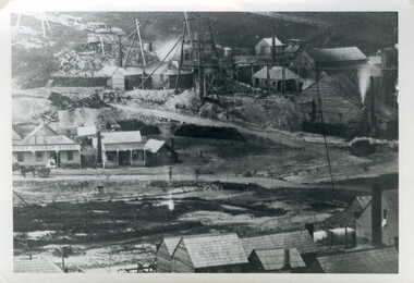 Clunes Museum
Photograph, JEAN GORDON GOVERNMENT PRINTER. MELBOURNE
BLACK AND WHITE PHOTOGRAPH OF PORT PHILLIP MINE - LOOKING NORTH FROM WEST SIDE OF CAMP HILL.TULLAROOP CREEK WITH CAMP STREET FORD, PORT PHILLIP HOTEL AND MINING BUILDINGS AND MINING CONSTRUCTIONSphotographs, mining, port phillip mine -
Whitehorse Historical Society Inc.
Article, Mayoral blast for M.P, 1994
Mayor of Nunawading, Noel Spurr, has made a scathing attack on Box Hill M.P., Robert Clark, for his role in trying to push for West Box Hill residents to be joined with the City of Boroondara.Mayor of Nunawading, Noel Spurr, has made a scathing attack on Box Hill M.P., Robert Clark, for his role in trying to push for West Box Hill residents to be joined with the City of Boroondara.Mayor of Nunawading, Noel Spurr, has made a scathing attack on Box Hill M.P., Robert Clark, for his role in trying to push for West Box Hill residents to be joined with the City of Boroondara.local government, spurr, noel, clark, robert, city of nunawading, city of box hill, amalgamations -
Whitehorse Historical Society Inc.
Document, Bridge divides locals, 2010
Report of proposal by Deakin University, Burwood Campus to construct a 200m. bridge over Gardiners Creek to connect two portions of its campus, and comments from West Elgar Residents Association spokeswoman.Report of proposal by Deakin University, Burwood Campus to construct a 200m. bridge over Gardiners Creek to connect two portions of its campus, and comments from West Elgar Residents Association spokeswoman.Report of proposal by Deakin University, Burwood Campus to construct a 200m. bridge over Gardiners Creek to connect two portions of its campus, and comments from West Elgar Residents Association spokeswoman.west of elgar residents association, gardiners creek, deakin university. burwood campus -
Whitehorse Historical Society Inc.
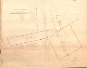
Map, before 1890
Early map showing location and areas of plots and their owners' names between Heatherdale Road in the east and Springvale Road in the west, Burwood Road to the south to north of Canterbury Road. Later additions to 1969Early map showing location and areas of plots and their owners' names between Heatherdale Road in the east and Springvale Road in the west, Burwood Road to the south to north of Canterbury Road. Later additions to 1969Early map showing location and areas of plots and their owners' names between Heatherdale Road in the east and Springvale Road in the west, Burwood Road to the south to north of Canterbury Road. Later additions to 1969mitcham, vermont, nunawading -
Whitehorse Historical Society Inc.
Map, City of Whitehorse, 1/03/1995 12:00:00 AM
Map showing streets of the City of Whitehorse from Mullum Mullum Creek to the north to Highbury Road and Warrigal Road in the west, to Heatherdale Road in the east.Map showing streets of the City of Whitehorse from Mullum Mullum Creek to the north to Highbury Road and Warrigal Road in the west, to Heatherdale Road in the east. Prep. by Richard Meloni. Scale 1:15,000Map showing streets of the City of Whitehorse from Mullum Mullum Creek to the north to Highbury Road and Warrigal Road in the west, to Heatherdale Road in the east. city of whitehorse, mullum mullum creek -
 Whitehorse Historical Society Inc.
Photograph, Narmara Primary School, 13/01/1994 12:00:00 AM
Coloured photo of Narmara Primary School, looking West along Highbury Road. School on North side of Highbury Road between Middleborough and Blackburn Roads. Since demolished and site developed for housing.narmara primary school, warner, philip -
 Whitehorse Historical Society Inc.
Photograph, Mitcham North Shopping Centre, 2006
Coloured Photo of Mitcham North Shopping Centre (opposite Park Road) looking south. Communications towers situated on roof of a security service building. Land surveyor and chemist on right (west side ).mitcham north shopping centre, shops, shopping centre -
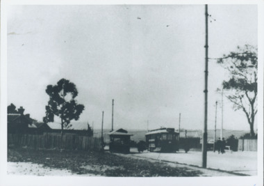
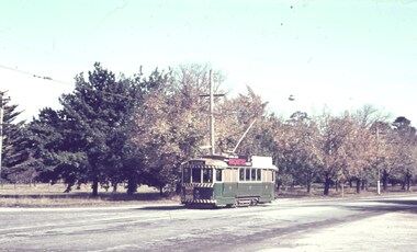 Ballarat Tramway Museum
Slide - 35mm slide/s, Robert Thomson, 27/04/1965 12:00:00 AM
Yields information about trams Sturt St West.Agfa blue/white mount, colour slide of tram 12, inbound to Mt Pleasant in Sturt St West. Tram has a Civic Hall dancing advert on the front and a Briquettes roof advert."27-4-65" in ink.tramways, trams, sturt st west, mt pleasant, tram 12 -
 Bendigo Historical Society Inc.
Document - MARKS COLLECTION: HOBSON AND LANSELL PLANS SHOWING LAND IN DISPUTE
Plan, hand drawn, showing Hobson and Lansell plan 'shewing ground in dispute' On plan East Johnson Lease Ground, Hobson and Lansell land in between, West of England company on bottom of plan.bendigo, mining, hobson and lansell -
 Kew Historical Society Inc
Photograph - Harp of Erin Tram Terminus, 1977
An electrified tram route from Melbourne along High Street replaced an original Horse Tram that terminated at the Kew Cemetery. This new tram only reached the bridge over the Outer Circle railway at the Harp Junction. The line was later extended to North Balwyn.Black and white print enlargement of the Tram Terminus in High Street, Kew at the Harp of Erin hotel. The rear of the photograph identifies it as an enlargement donated by Stewart West from an original owned by Miss Foley.tramways, mmtb, tram terminus, no 48 tram route, harp of erin hotel, trams - kew, trams - kew east -
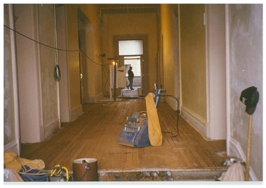 Queen Victoria Women's Centre
Photograph, c.1995/1996
Colour photograph. Level one corridor facing towards women's space and Lonsdale street of the QVWC building. Figure of a person in the women's space room faces west. Taken during a renovation inspection. building construction, historic buildings, cultural structures and establishments -
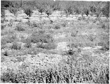 University of Melbourne, Burnley Campus Archives
Photograph - Black and white print, Views Not Burnley
5 photographs which do not appear to be of Burnley Gardens and have not been identified. 6 photographs of what might be the West Orchard. "192" written on the reverse of them. May be photographs for Lantern Slides.garden views, plants, west orchard, fruit trees -
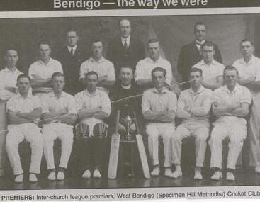 Bendigo Historical Society Inc.
Newspaper - JENNY FOLEY COLLECTION: PREMIERS
BHS CollectionBendigo Advertiser ''the way we were'' from Thursday, January 22, 2004. Premiers: inter-church league premiers, West Bendigo (Specimen Hill Methodist) Cricket Club. The clip is in a folder.newspaper, bendigo advertiser, the way we were -
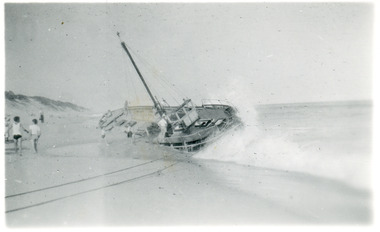 Lakes Entrance Historical Society
Photograph - Black Fin, 1953 c
Also black and white enlargement 16 x 25 cmBlack and white photograph showing fishing boat 'Black Fin' aground at Corringle Beach near Orbost. Picture shows boat broadside to beach with bow facing west. Lakes Entrance Victoriacoast, shipwrecks, ships and shipping -
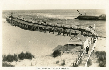 Lakes Entrance Historical Society
Postcard - Entrance Beach, 1920c
One other copy black and white 11.5 x 20 cmSepia postcard showing east and west piers and entrance from ocean - Bass Strait into Gippsland Lakes, at Lakes Entrance, Victoria. Several people on upper deck of eastern pier and on beach and boardwalk.The Piers at Lakes Entrancewaterways, piers, beaches, kiosk