Showing 10971 items matching " plan."
-
 Bendigo Historical Society Inc.
Map - CAMPBELL COLLECTION: BENDIGO AND DISTRICT MAPS
Map. Whirrakee, Parish of Whirrakee. Total area of map 4419 acres. Scale 20 chains to 1 inch. 23 allotments are sold, Eucalypt oil distillery on lower portion of map. Prepared in W.P.B. from Assessor's plan and Parish Plan. (number 350 in map cupboard 1)map, bendigo, allotments -
Whitehorse Historical Society Inc.
Article, Say no to pokies: shoppers alarm, 1992
Residents will fight plans to develop a tavern with 90 poker machines in Forest Hill Chase Shopping Centre.Residents will fight plans to develop a tavern with 90 poker machines in Forest Hill Chase Shopping Centre. Nunawading Council's strategic planning department's spokesman, Richard Schuster, said the 3rd level at the Centre has developed into an entertainment level. The matter has not gone before Council at this stage.Residents will fight plans to develop a tavern with 90 poker machines in Forest Hill Chase Shopping Centre.shopping centres, forest hill chase, city of nunawading, schuster, richard -
 Bendigo Historical Society Inc.
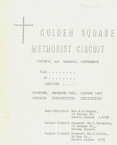
Document - Golden Square Methodist Church, 11/11/1966
Golden Square Methodist Church is situated at 2a Laurel St., Golden Square and was built in 1852. It no longer serves as a church and was sold in 2016.Eight page booklet of the Victoria and Tasmania Conferences, and plan of services. Contains Circuit News and Notes, Plan of Services for divine worship for the Golden Square, specimen Hill, Kangaroo Flat and Lockwood Methodist Churches, financial statements for quarter ending 25th September 1966, and a list of the church officials.religion, lydia chancellor collection, history, church -
 Bendigo Historical Society Inc.
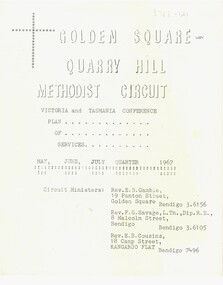
Document - Golden Square Methodist Church Circuit, 01/05/1967
Golden Square Methodist church is situated at 2a Laurel St., Golden Square and was built in 1852. It no longer serves as a church and was sold in 2016.Eight page booklet of the Victoria and Tasmania Conferences, and plan of services. Contains Circuit News and Notes, Plan of Services for divine worship for the Golden Square, specimen Hill, Kangaroo Flat and Lockwood Methodist Churches, financial statements for quarter ending 31 March 1967, and a list of the church officials.religion, lydia chancellor collection, history, church -
 Falls Creek Historical Society
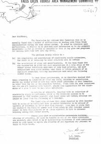
Letter - Commission Advises Of Difficulties In Administration During Summer Period
Bob (Herman) Hymans (a former member of the Royal Netherlands Navy) was born in Bloemendaal, Holland on 30th September 1922. During World War II he fought against the Japanese in the Dutch East Indies (now Indonesia) and was imprisoned in Changi and on the Burma Railway. After gaining qualifications as a Ski Instructor, Bob arrived in Falls Creek in July 1950. Working as an Instructor and Supervisor at Bogong Lodge, Bob decided his future was in accommodation. He was successful in negotiating an indenture for land from the State Electricity Commission (SEC). It took Bob two years to build his Grand Coeur Chalet but, tragically, it was burned down in August 1961. Bob also built the first Chairlift in Australia. This was a single chairlift and the structure was built from wooden electricity poles. He was constantly full of new ideas and proposals for the village. Bob Hymans died on 7th July 2007. This Collection of documents and letters tells the story of Bob's endeavours to develop Falls Creek into the ski village it is today.This letter is significant because it documents developments made or endorsed by the Falls Creek Tourist Area Management Committee.A letter from the Management Committee outlining potential delays for the SEC in regard to programming and construction of extensions to the electricity supply over the summer. Early notification of plans for any extensions or new developments requiring additional supply were required by 31st October with full plans to be submitted by 15th December. falls creek tourist area management committee, chairlift licence negotiations, double chairlift -
 Ballarat Tramway Museum
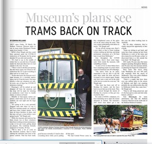
Newspaper, Edwina Williams, "Museum's plans see Trams back on track", 9/07/2020 12:00:00 AM
Digital image of an item in the 9-7-2020 issue of Ballaarat Times, titled "Museum's plans see Trams back on track" about the planning to re-open the museum following the lifting of restrictions due to Covid-19. Includes notes on the operation of the trams from the depot only and limitations. But these came to naught when the plan to lift restrictions did not go ahead and there was a further lockdown in the Melbourne area. Has a photo of Peter Waugh standing on a step of No. 13 with a limitation sign on it.btm, closure, covid-19 -
 Warrnambool and District Historical Society Inc.
Letter Book 4, 1901, 1908
This letter book has letters, invoices, sketch maps and plans and dates from 1908 to 1910. It came from the office of John William Crawley Junior, an engineer, architect and surveyor in private practice in Warrnambool and also the official engineer of the Shire of Warrnambool from 1895 to 1935. His father, brother and son were also engineers and worked in that capacity or as the Shire Secretary for the Shire of Warrnambool, with the Crawley family members recording a total of 132 years of service to the Shire. The letter book was passed on to John Crawley’s son, Rolf, Engineer for the Shire of Warrnambool from 1935 to 1968. The letter book then came into the possession of Michael Hand who took over the private surveying business of Rolf Crawley in Warrnambool and the Warrnambool and District Historical Society has acquired the letter book, one of several Crawley ledgers, from the Michael Hand estate. This letter book is of considerable significance as it contains maps, plans, sketches and written information on the work of John William Crawley, the engineer for the Shire of Warrnambool for 40 years. This is a black-covered letter book with copies of letters and field maps and plans and an alphabetical listing at the front. Some of the letters are invoices for work carried out. The leather section of the front cover has been almost completely torn away and the binding is mended with adhesive tape. There are some torn pages. The front page has a signature and a mauve stamp. ‘Letter Book’ ‘J.Wm. Crawley (Private)’ ‘ Rolf L. Crawley, Civil Engineer, Drainage and Water Supply Engineer, Licensed Surveyor, Registered Architect, Warrnambool’ ‘4’ rolf crawley, warrnambool, john william crawley, junior, warrnambool, history of warrnambool -
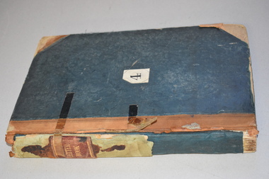
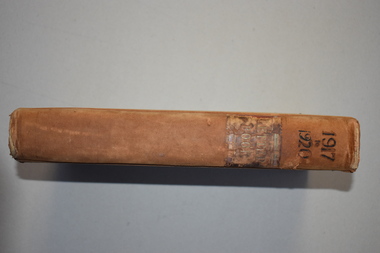 Warrnambool and District Historical Society Inc.
Letter book 7, 1917-1920, 1917
This letter book contains handwritten letters, sketch maps and plans and dates from 1917 to 1920. It comes from the office of John William Crawley Junior, an engineer, architect and surveyor in private practice in Warrnambool and also the engineer for the Shire of Warrnambool from 1895 to 1935. His father, brother and son were also engineers and worked in that capacity or as Shire Secretary for the Shire of Warrnambool, with the Crawley family recording 132 years of service with the Shire of Warrnambool. The Shire existed from 1863 to 1994. The letter book was passed on to John Crawley’s son, Rolf, the engineer for the Shire of Warrnambool from 1935 to 1968. The letter book then came into the possession of Michael Hand who took over the private surveying business of Rolf Crawley in Warrnambool. The Warrnambool and District Historical Society then acquired this letter book, along with other Crawley ledgers, from the Michael Hand estate. This letter book is of considerable significance as it contains letters, plans and maps drawn up John William Crawley Junior, the engineer for the Shire of Warrnambool for 40 years. It will be very useful for research. This is a hard cover book of 745 pages. It has leather trim on the cover edges and the spine with gold lettering on the spine. The leather covering is scuffed and torn. The inside covers have a mottled blue lining. The book contains maps, plans and handwritten letters and has an alphabetical index at the beginning of the book. Most of the pages have been water-stained. ‘7 Private’ ‘Letter Book 1917 to 1920’john william crawley junior, warrnambool, rolf crawley, warrnambool, shire of warrnambool -
 Bendigo Historical Society Inc.
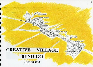
Book - MERLE HALL COLLECTION: ROSALIND PARK CREATIVE VILLAGE BENDIGO PROJECT BOOK, 1995
Merle Hall Collection: Rosalind Park Creative Village Bendigo Project Book. August 1995 Book contains a description, aims of the programme and a linking plan. 35 Pages: Cover Intoduction, The Design Team, Acknowledgement Project Brief Map of Linked Park The Linking Plan described Linking plan graphic Golden Beacon Design Concept Bridge Beacon Entrance to Linear Park Gasworks Café Pavillion Gasworks layout plan Golden Beacons Concept Botanical Gardens Café Botanical Gardens layout plan Victoria Hill Interpretation Centre Victoria Hill layout Victoria Hill plan Victoria Hill continued Victoria Hill continued Rosalind Park Lookout Method 3D Road Map 3D Road Map Continued Implementation Community Participation Oppurtunities, Mosaic Works Appropriate sites Appropriate sites continued Consultaion Summary and Issues Ideas Areas for further consideration Graphic The Design Team - Grant Fink, Jane Marriott, Laszo Biro, James Brearley Graphic Layoutbook -
University of Melbourne, Burnley Campus Archives
Plan, Richmond Primary School 'Prep Garden', 1994
(1) Coloured Section Elevation and Detail Suggestion by Frances Saunders August 1994. (2) Coloured Preliminary Plan, Landscape Graphics by Rachel Dann dated 16.8.94. Scale 1:50. (3) Site Analysis & Inventory. Scale 1:50. (4) 2 copies, 1 coloured, Section Elevations by N. Herzberg. Scale 1:50. (5) Coloured plan, Secret Garden by Julie Tydens p3 of 3 dated 22.8.94. Scale 1:50. (6) Coloured Preliminary Plan by Jacinta Chong Sheet 3 of 3 dated 22 Aug 1994. Scale 1:100. (7) 2 tracing paper and 1 paper Site Plan drawn by JK. Scale 1:50 and 1:100. (8) Coloured Section Elevation for Landscape Graphics by Rachel Dann dated 22.08.1994. Scale 1:50. (9) Coloured Preliminary Plan dated August 1994 by Frances Saunders. Scale 1:100. (10) Preliminary Plan Sheet No 3 of 3 dated 18.08.1994 by Ian Porterfrances saunders, rachel dann, julie tydens, jacinta chong, ian porter, richmond primary school, gardens, jill kellow -
 Ringwood and District Historical Society
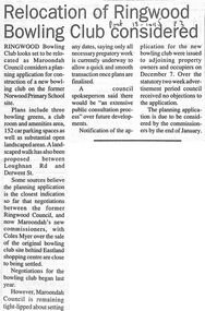
Newspaper, Scrapbook Clipping, Library Collection, Ringwood, Victoria, `
``Newspaper clipping from The "Post" , 18-1-95 P3. Relocation of Ringwood Bowling Club consideredRingwood Bowling Club looks set to be relocated as Maroondah Council considers a planning application for construction of a new bowling club on the former Norwood Primary School site.` -
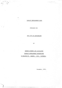 Old Castlemaine Schoolboys Association Inc.
Document, George Hibbert and Associates, The Hibbert Report
TOURIST DEVELOPMENT PLAN PREPARED FOR THE CITY OF CASTLEMAINE BY GEORGE HIBBERT AND ASSOCIATES TOURIST DEVELOPMENT ENTERPRISES 53 MILTON ST. ELWOOD. 3184. VICTORIA. November, 1972. -
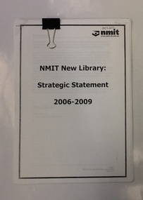 NMIT (Northern Melbourne Institute of TAFE)
Report - NMIT, NMIT New Library: strategic statement 2006-2009, August 2006
A collection of documents and reports related to the NMIT library strategic plan 2006-2009. This plan recognises changes to library service and sets down the plan for NMIT libraries in the first decade of the 21st century. Includes 2 copies of Library Operational Plan August 2007The role of libraries and librarians changed in response to changing client expectations, and new and emerging technologies. This document is NMIT's strategic plan to deliver services relevant to the needs of its clientele.A collection of documents and reports, text printed on white paper. Each document stapled in top left corner, collection held together with large clip.Some passages highlighted with pencilled stars.libraries, student focus in libraries, library operational plan, library staff, nmit, -
 Kew Historical Society Inc
Plan - Subdivision Plan, Erin Heights Estate, East kew, 1917
Pru Sanderson, in her groundbreaking ‘City of Kew Urban Conservation Study : Volume 2 - Development History’ (1988), summarised the periods of urban development and subdivisions of land in Kew. The periods that she identified included 1845-1880, 1880-1893, 1893-1921, 1921-1933, 1933-1943, and Post-War Development. These periods were selected as they represented periods of rapid growth or decline in urban development. An obvious starting point for Sanderson’s groupings involved population growth and the associated economic cycles. These cycles also highlighted urban expansion onto land that was predominantly rural, although in other cases it represented the decline and breakup of large estates. A number of the plans in the Kew Historical Society’s collection can also be found in other collections, such as those of the State Library of Victoria and the Boroondara Library Service. A number are however unique to the collection.The Kew Historical Society collection includes almost 100 subdivision plans pertaining to suburbs of the City of Melbourne. Most of these are of Kew, Kew East or Studley Park, although a smaller number are plans of Camberwell, Deepdene, Balwyn and Hawthorn. It is believed that the majority of the plans were gifted to the Society by persons connected with the real estate firm - J. R. Mathers and McMillan, 136 Cotham Road, Kew. The Plans in the collection are rarely in pristine form, being working plans on which the agent would write notes and record lots sold and the prices of these. The subdivision plans are historically significant examples of the growth of urban Melbourne from the beginning of the 20th Century up until the 1980s. A number of the plans are double-sided and often include a photograph on the reverse. A number of the latter are by noted photographers such as J.E. Barnes.The Erin Heights Estate in Kew included just seven lots in in Valerie Street. These were all that remained of this wartime subdivision, the other 11 allotments on Balfour and Belford Roads having already been sold. Balfour Road was to be only a temporary name as the street is currently called Windella Avenue. Now, the parkland opposite the subdivision is the reserve created from the route of the Outer Circle Railway. This Railway reached Kew East in 1925, but had been planned as far back as 1873. The development focuses on the benefits of living in Kew: being at the highest of Kew’s ‘suburbs’; being a good residential area; its rapid growth; and the proximity of the Kew East tram in High Street. In 1917, the electric tramline only extended to a terminus at the Harp of Erin hotel. The terminus is clearly represented on the plan.subdivision plans - east kew, erin heights estate -
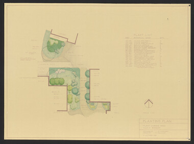 University of Melbourne, Burnley Campus Archives
Plan, Student Amenity Building (Citriodora) Courtyard, 1988-2000
Various plans for what is now known as the "Citriodora Courtyard." I copy tracing paper, 1 coloured original, 4 copies with additional notation 6 smaller copies with additional notation. (1) Planting Plan Plant Science Area V.C.A.H. Burnley designed by J. Hitchmough, drawn by S. Mullany 3 October 1988. (2) Student Amenity Quad Sketch Proposal by M. Green May '95. (3) Rough pencil design, New Design related to Horticultural pursuits of Burnley College. (4) Coloured, Proposed Citriodora Court Redevelopment. (5) 2 copies Citriodora Courtyard Presentation Concept Plan by Adrian Bonifacio. November 2000. (6) Landscape Graphics II Assoc. Diploma in Horticulture (Amenity) Assignment 2 - Planting Plan May 1988. (7) Laminated, Preliminary Plan 2 of 4 Citriodora Lawn Burnley by Kate Szmal B.A.S.H. (8) Laminated, Preliminary Plan Student Amenity Building Courtyard V.C.A.H. Burnley by Caroline Lodge. (9) 1 tracing paper and 1 paper copy University of Melbourne Burnley College Student Amenity Building Courtyard 19.8.99. (10) Setout Plan, Planting Plan & Surface Finishes, Details Courtyard & Entrance, ACM Landscape Architecture: Concrete Paving Topsoil, Mulch - notes. "Phil Tulk," handwritten on reverse. (11) Laminated, V.C.A.H. Preliminary Plan p3 of 5 Project No 1 Student Amenity Building Courtyard by K. Watson 15-8-95. (12) Citriodora Courtyard Redevelopment Concept Plan by Judy Brookes November 2000. 2 copies of Drawing 1 of 2, 1 copy Drawing 2 of 2. (13) Proposed Outdoor Eating Area Student Amenities Block: Scheme 1 pp 2-5 of 5, 16.10.96. Scheme 2 pp 3-5 of 5, 16.10.96. Scheme 8 3 copies p1 of 2, 2 copies p2 of 2, 23.6.97, Paving Types p1 of 1, 30.9.99, handwritten on reverse,"to Phil from Nicki." (14) 2 copies Entry from Rear Car Park Paving Plan. (15) Plan by Margaret Kitching 8.8.90. citriodora courtyard, vcah, centenary courtyard, plant science area, k. watson, s. mullaney, j. hitchmough, judy brookes, kate szmal -
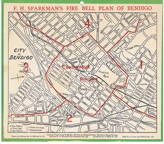 Bendigo Historical Society Inc.
Document - FIRE BELL PLAN OF BENDIGO
Plan Document. A Fire Bell Plan of Bendigo issued by F.H.Sparkman. A street map of Bendigo split up into a central zone plus four surrounding zones. It is probably the upper part of a calendar with the date section missing (torn off). F.H.Sparkman was a printer and a Mason. Date not shown but probably prior to 1950F.H.Sparkmanessential services, firefighting, fire bell plan of bendigo, fire bell plan, f.h.sparkman -
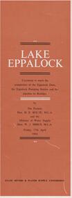 Bendigo Historical Society Inc.
Document - LAKE EPPALOCK - OPENING CEREMONY PROGRAM
Folded document, 5 pages, produced to commemorate the opening of the Eppalock Dam, the Eppalock Pumping Station and the pipeline to Bendigo, by the Premier, Mr. H. Bolte, on 17th April, 1964. Brown cover, cream and black text. Illustrations show the cross section of the tunnel; a plan of the embankments and an overall plan of the weir.bendigo, waterworks, lake eppalock -
University of Melbourne, Burnley Campus Archives
Plan, Alton-Hascombe Feature Survey, c. 1990
1 tracing paper and 2 paper copies of plan by Department of Conservation, Forests and Lands, Division of Survey and Mapping, of adjoining gardens Alton and Hascombe at Mount Macedon, Victoria. Scale 1:1000. Plan of properties includes buildings, gardens and paddocks. 1 copy has significant buildings coloured.feature survey, mount macedon, gardens, alton, hascombe -
 Flagstaff Hill Maritime Museum and Village
Document - Navigation Chart, The Melbourne Harbor Trust Commissioners
Navigation Chart - The Melbourne Harbor Trust Commissioners - General Plan - Shewing proposed Harbor Improvements. Hobson's Bay and Citywarrnambool, shipwrecked-coast, flagstaff-hill, flagstaff-hill-maritime-museum, maritime-museum, shipwreck-coast, flagstaff-hill-maritime-village, shipwrecked-artefact, navigation chart, hobson's bay, the melbourne harbor trust -
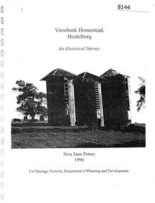 Greensborough Historical Society
Booklet, Sera Jane Peters, Viewbank Homestead, Heidelberg: an historical survey, by Sera Jane Peters for Heritage Victoria, Department of Planning and Development, 1996
History of the Viewbank Homestead, originally a 90 acre site with homestead and outbuildings, now demolished.Black and white photocopy of typescript, with photographs, plans, reproductions of documents. 25 p plus 17 p of Appendices, unboundviewbank homestead, heritage victoria -
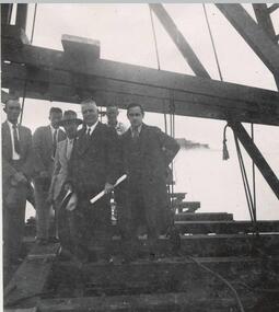 Phillip Island and District Historical Society Inc.
Photograph
One of a collection of over 400 photographs in an album commenced in 1960 and presented to the Phillip Island & Westernport Historical Society by the Shire of Phillip IslandPhotograph of men at the ceremony of the driving of the first pile for the first Phillip Island Bridge - Mr Richard Grayden holding plan.local history, photographs, group of six men on timber framework, black & white photograph, phillip island bridge, first pile driving ceremony, mr r a grayden, first phillip island bridge to san remo, john jenner, bryant west -
Glenelg Shire Council Cultural Collection
Book, Benedict, What To Do At Weddings, c. 1951
Small booklet, a guide for brides, grooms and others involved in wedding planning. Grey card cover, red and navy print. -
4th/19th Prince of Wales's Light Horse Regiment Unit History Room
Booklet (2 copies), Central Drawing Office, Infantry Training Vol 1 Infantry Platoon Weapons Pam 3B The 7.62 Self Loading Rifle and Bayonet, 1961
A soft covered booklet containing the material necessary to equip an instructor on the weapon. The booklet is set out in lesson plan format.7610-66-013-1640rifle 7.62 slr -
Ringwood and District Historical Society
Envelope, Packet: Town Planning Act 1944 and Greater Melbourne Printed Matter and Correspondence
Packet 2 (of 2); Town Planning Act 1944 Municipal Administration Institute Pamphlets and minutes of general meetings; Correspondence -
Ringwood and District Historical Society
Legal record - Conditions of Sale (C.E.Carter), Mitcham - Crown Allotment 124. M.E.Burke to ? Dated June 1st 1929
Particulars and Conditions of Sale of Property , Lot 44 and 45 on Plan of Subdivision 6736, Mitcham Road, Mitcham. Mrs M.E.Burke to ? -
 Federation University Historical Collection
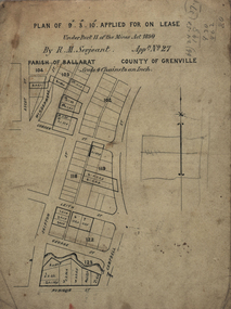
Plan, Lease Applied for by R.M. Serjeant, c1890, c1890
Plan of a lease showing streets around Skipton and Windermere Streets, Redan. Scale 4 chains to 1 inch (!:3168)serjeant, r.m.serjeant, robert m. serjeant, george street, skiptn street, windermere stret, rubicon stret, cobdon street, ascot street, lease, redan, ballarat, robert malachi serjeant, band of hope and albion mine -
Federation University Historical Collection
Book, City of Ballaarat Planning Scheme Review: Planning Policies Identification Summary Report, 1980, 02/1980
Brown soft covered book outlining the City of Ballarat Planning Scheme Review . Includes black and white images and a map.city of ballaarat, city of ballarat planning, planning scheme review, map -
Federation University Historical Collection
Poster, University of Ballarat Camp Street Campus, 2000, 2000
The University of Ballarat became Federation University Australia in 2014. The Camp Street Campus was later known as the Arts Academy. Framed poster of a collage of images showing plans for the University of Ballarat Camp Street Campus, later known as the Arts Academy. "In acknowledgement of the joint agreement to redevelop historic camp Street as a dynamic arts precinct utilising the central business district area of Ballarat."arts academy, camp street precinct, camp street, arts precinct -
 Federation University Historical Collection
Plan, Ballarat School of Mines E.J. Tippett Learning Resource Centre Signs, 19/05/1986
Plans for signage of the Ballarat Sxhool of Mine Library - The E.J. Tippett Learning Resource Centre. Includes front elevation of building. plan, tippett library, e.j. tippett library, e.j. tippett learning resource centre, gadsden signs, ballarat schoo of mines -
 Ringwood and District Historical Society
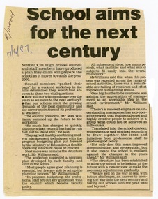
Newspaper - Clipping, Norwood High School, Ringwood, Victoria - "School aims for the next century"
Newspaper report June1987 outlining 21st century planning workshop topics addressed by council president Mr Max Williams.