Showing 3609 items
matching track
-
 Marysville & District Historical Society
Photograph (Item) - Black and white photograph, Beech Forest Beyond Tommy's Bend, c1900
An early black and white photograph of The Beeches, which is known as the Beech Grove, near Tommy's Bend near Marysville in Victoria.An early black and white photograph of The Beeches, which is known as the Beech Grove, near Tommy's Bend near Marysville in Victoria. Tommy's Bend is a stretch of road 10 kilometres from Marysville on the Wood's Point Road up to Lake Mountain. The Beeches Rainforest Walk is a loop that starts at Taggerty Cascades before winding through Myrtle Beech and Mountain Ash woodland and is one of the many walking tracks in and around Marysville. It is accessible from Lady Talbot Drive which is a 24 kilometer scenic rainforest car journey which passes a number of walks and waterfalls in the Yarra Ranges National Park. Lady Talbot Drive is named after Lady Sarah Elizabeth, the wife of Sir Reginald Talbot, who was the Governor of Victoria from 25th April, 1904 to 6th July 1908.ARMSTRONG COLLECTION 42 STATION STREET/ SANDRINGHAM 3191/ TEL. (03) 9521 5442/ IAN M.L. ARMSTRONG OAMtommy's bend, marysville, victoria, marysville-wood's point road, beech grove, wood's point road, lake mountain, beeches rainforest walk, taggerty cascades, myrtle beech, mountain ash, lady talbot drive, lady talbot forest drive, lady sarah elizabeth talbot, sir reginald talbot -
 Marysville & District Historical Society
Photograph (Item) - Black and white photograph, Bridge Over The Cumberland, c1900
An early black and white photograph of a bridge over the Cumberland Creek near Marysville in Victoria.An early black and white photograph of a bridge over the Cumberland Creek near Marysville in Victoria. The Cumberland Creek is in the Cumberland Valley near Cambarville which was a timber town near Marysville. Cambarville is notable for its giant mountain ash (Eucalyptus regnans) trees within the Cumberland Memorial Scenic Reserve, and relics from former sawmills and gold mining. The Big Culvert is located nearby on the Marysville - Woods Point Road, which was historically part of the Yarra Track. Cambarville was established as a timber mill town in the 1940s. Timber mill owners A Cameron and FJ Barton named Cambarville. They established the mill to salvage timber from trees destroyed in the 1939 bushfires. Cambarville was impacted by the 2009 Black Saturday bushfires and any remaining structures were destroyed.ARMSTRONG COLLECTION 42 STATION STREET/ SANDRINGHAM 3191/ TEL. (03) 9521 5442/ IAN M.L. ARMSTRONG OAMcumberland creek, marysville, victoria, cumberland valley, cambarville, mountain ash, eucalyptus regnans, cumberland memorial reserve, the big culvert, marysville-wood's point road, yarra track, a cameron, fj barton, 2009 black saturday bushfires -
 Marysville & District Historical Society
Photograph (Item) - Black and white photograph, Way to Cumberland Falls, c1900
An early black and white photograph of the forest near the Cumberland Falls in Victoria.An early black and white photograph of the forest near the Cumberland Falls in Victoria. The falls are located on the Marysville-Wood's Point Road. Cambarville is notable for its giant mountain ash (Eucalyptus regnans) trees within the Cumberland Memorial Scenic Reserve, and relics from former sawmills and gold mining. The Big Culvert is located nearby on the Marysville - Woods Point Road, which was historically part of the Yarra Track. Cambarville was established as a timber mill town in the 1940s. Timber mill owners A Cameron and FJ Barton named Cambarville. They established the mill to salvage timber from trees destroyed in the 1939 bushfires. Cambarville was impacted by the 2009 Black Saturday bushfires and any remaining structures were destroyed.ARMSTRONG COLLECTION 42 STATION STREET/ SANDRINGHAM 3191/ TEL. (03) 9521 5442/ IAN M.L. ARMSTRONG OAMcumberland falls, cambarville, marysville, victoria, waterfalls, postcard, souvenir, mountain ash, mining, timber mills, big culvert, yarra track, a cameron, fj barton, black saturday bushfires, 1939 bushfires, eucalyptus regnans -
 Marysville & District Historical Society
Photograph (Item) - Black and white photograph, Cumberland Falls, c1900
An early black and white photograph of Cumberland Falls near Marysville in Victoria.An early black and white photograph of Cumberland Falls near Marysville in Victoria. These falls are located on the Marysville-Wood's Point Road. Cambarville is notable for its giant mountain ash (Eucalyptus regnans) trees within the Cumberland Memorial Scenic Reserve, and relics from former sawmills and gold mining. The Big Culvert is located nearby on the Marysville - Woods Point Road, which was historically part of the Yarra Track. Cambarville was established as a timber mill town in the 1940s. Timber mill owners A Cameron and FJ Barton named Cambarville. They established the mill to salvage timber from trees destroyed in the 1939 bushfires. Cambarville was impacted by the 2009 Black Saturday bushfires and any remaining structures were destroyed.ARMSTRONG COLLECTION 42 STATION STREET/ SANDRINGHAM 3191/ TEL. (03) 9521 5442/ IAN M.L. ARMSTRONG OAMcumberland falls, cambarville, marysville, victoria, waterfalls, postcard, souvenir, mountain ash, mining, timber mills, big culvert, yarra track, a cameron, fj barton, black saturday bushfires, 1939 bushfires, eucalyptus regnans -
 Marysville & District Historical Society
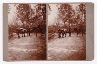
Photograph (Item) - Black and white bi-focal image, Unknown
An early black and white bi-focal image of men and packhorses on the Marysville-Wood's Point Road in Marysville in Victoria.An early black and white bi-focal image of men and packhorses on the Marysville-Wood's Point Road in Marysville in Victoria. This is now known as the Marysville-Wood's Point Road. The Marysville-Woods Point Road was originally part of the Yarra Track, constructed in the early 1860s to provide access between Healesville and the Woods Point Goldfields. Despite the steep terrain and engineering difficulties, the Yarra Track soon became a busy route used by pack horses, horse-drawn drays, and wagons. Today this sealed mountain road is a popular scenic drive between Marysville and Warburton.Packhorses on Wood'spoint Road/ Marysville/ Victoriapackhorses, wood's point road, marysville-wood's point road, marysville, victoria, yarra track, healesville, wood's point goldfields, warburton -
 Marysville & District Historical Society
Document (Item) - Newspaper article, The Argus, New Tourist Road. Marysville to Wood's Point Magnificent Forest Scenery, 02-1924
A newspaper article regarding the opening of the Marysville-Wood's Point Road in February 1924.A newspaper article regarding the opening of the Marysville-Wood's Point Road in February 1924. The Marysville-Woods Point Road was originally part of the Yarra Track, constructed in the early 1860s to provide access between Healesville and the Woods Point Goldfields. Despite the steep terrain and engineering difficulties, the Yarra Track soon became a busy route used by pack horses, horse-drawn drays, and wagons. Today this sealed mountain road is a popular scenic drive between Marysville and Warburton.marysville-wood's point road, yarra track, healesville, wood's point goldfields, warburton, the argus -
 Marysville & District Historical Society
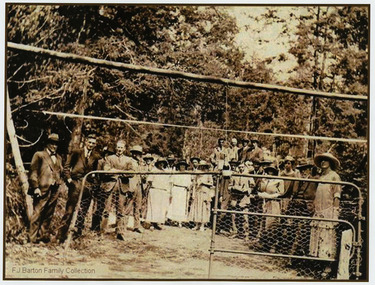
Photograph (Item) - Black and white photograph, 05-02-1924
An early black and white photograph of the ceremonial re-opening of the Marysville-Wood's Point Road in 1924.An early black and white photograph of the ceremonial re-opening of the Marysville-Wood's Point Road in 1924. The Marysville-Woods Point Road was originally part of the Yarra Track, constructed in the early 1860s to provide access between Healesville and the Woods Point Goldfields. Despite the steep terrain and engineering difficulties, the Yarra Track soon became a busy route used by pack horses, horse-drawn drays, and wagons. Today this sealed mountain road is a popular scenic drive between Marysville and Warburton.F.J. Barton Family Collectionmarysville-wood's point road, marysville, wood's point goldfields, healesville, yarra track, warburton -
 Marysville & District Historical Society
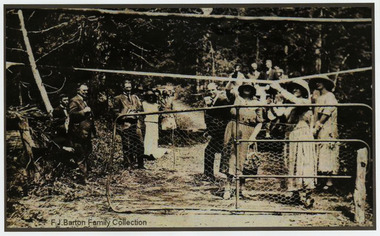
Photograph (Item) - Black and white photograph, 05-02-1924
An early black and white photograph of the ceremonial re-opening of the Marysville-Wood's Point Road in 1924.An early black and white photograph of the ceremonial re-opening of the Marysville-Wood's Point Road in 1924. The Marysville-Woods Point Road was originally part of the Yarra Track, constructed in the early 1860s to provide access between Healesville and the Woods Point Goldfields. Despite the steep terrain and engineering difficulties, the Yarra Track soon became a busy route used by pack horses, horse-drawn drays, and wagons. Today this sealed mountain road is a popular scenic drive between Marysville and Warburton.F.J. Barton Family Collectionmarysville-wood's point road, marysville, wood's point goldfields, healesville, yarra track, warburton -
 Marysville & District Historical Society
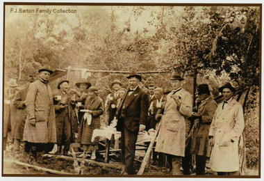
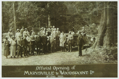
Photograph (Item) - Black and white photograph, Official Opening of MARYSVILLE to WOODSPOINT RD 5th Feb, 1923, 05-02-1924
An early black and white photograph which was taken after the ceremonial re-opening of the Marysville-Wood's Point Road in 1924. The date of 1923 on the photograph is incorrect.An early black and white photograph which was taken after the ceremonial re-opening of the Marysville-Wood's Point Road in 1924. The date of 1923 on the photograph is incorrect. The Marysville-Woods Point Road was originally part of the Yarra Track, constructed in the early 1860s to provide access between Healesville and the Woods Point Goldfields. Despite the steep terrain and engineering difficulties, the Yarra Track soon became a busy route used by pack horses, horse-drawn drays, and wagons. Today this sealed mountain road is a popular scenic drive between Marysville and Warburton.Official Opening of/ MARYSVILLE to WOODSPOINT RD/ 5th Feb, 1923marysville-wood's point road, marysville, wood's point goldfields, healesville, yarra track, warburton, the argus -
Marysville & District Historical Society
Document (Item) - Research Document, Judith Vimpani, William Cavanagh Farrell (1844-1901), 04-2020
An account of the life of William Cavanagh Farrell.An account of the life of William Cavanagh Farrell who was important to Marysville as his review in 1863 of the routes to Wood's Point led to the Yarra Track ascending the Black Spur and going on to what became the resort town of Marysville on the Steavenson River. The Yarra Track is the former name of the gold fields road from Healesville to the Woods Point and Jordan Goldfields, in Victoria, Australia. A direct route via the Yarra River and the Great Divide was discovered by Reick in September 1862 and became known as the Yarra Track. Early in 1863, the Victorian Government decided to construct a 193-kilometre (120 mile) road along the route. Its original width varied between 4 and 6 metres (12 and 20 feet), and was designed to accommodate horse-drawn vehicles. The Track involved the climbing of the Black Spur, descent into the Acheron Valley, and then through Marysville to the Cumberland where it followed the existing route.willaim cavanagh farrell, marysville, victoria, wood's point, yarra track, black spur, steavenson's creek, steavenson river, george theodore rieck -
Marysville & District Historical Society
Document (Item) - Research Document, Judith Vimpani, George Theodore Rieck (1833-pos 1884), 04-2020
An account of the life of George Theodore Rieck.An account of the life of George Theodore Rieck. The Yarra Track is the former name of the gold fields road from Healesville to the Woods Point and Jordan Goldfields, in Victoria, Australia. A direct route via the Yarra River and the Great Divide was discovered by Rieck in September 1862 and became known as the Yarra Track. Early in 1863, the Victorian Government decided to construct a 193 kilometre (120 mile) road along the route. Its original width varied between 4 and 6 metres (12 and 20 feet), and was designed to accommodate horse-drawn vehicles. The Track involved the climbing of the Black Spur, descent into the Acheron Valley, and then through Marysville to the Cumberland where it followed the existing route.george theordore rieck, marysville, victoria, james murphy, new chum creek, wood's point, gold mining, matlock, walhalla, yarra track -
Marysville & District Historical Society
Booklet (Item) - Information booklet, Artworkz Tourism, The Big Culvert, Unknown
An information booklet that was produced as a guide to The Big Culvert.An information booklet that was produced as a guide to The Big Culvert. The Big Culvert is a historic granite and bluestone arch along the Yarra Track, a major route to Melbourne through the 1800s. Built in 1870 and a major piece of infrastructure for its time, the heritage listed culvert allowed water to flow under often-flooded the road. The Yarra Track is the former name of the gold fields road from Healesville to the Woods Point and Jordan Goldfields, in Victoria, Australia. A direct route via the Yarra River and the Great Divide was discovered by Rieck in September 1862 and became known as the Yarra Track. Early in 1863, the Victorian Government decided to construct a 193-kilometre (120 mile) road along the route. Its original width varied between 4 and 6 metres (12 and 20 feet), and was designed to accommodate horse-drawn vehicles. The Track involved the climbing of the Black Spur, descent into the Acheron Valley, and then through Marysville to the Cumberland where it followed the existing route.the big culvert, yarra track, victoria, healesville, wood's point goldfields, jordan goldfields, black spur, acheron valley, cumberland valley -
Marysville & District Historical Society
Flyer (Item) - Information flyer, Artworkz Tourism, The Big Culvert, 26-03-2016
An information flyer that was produced as a guide to The Big Culvert.An information flyer that was produced as a guide to The Big Culvert. The Big Culvert is a historic granite and bluestone arch along the Yarra Track, a major route to Melbourne through the 1800s. Built in 1870 and a major piece of infrastructure for its time, the heritage listed culvert allowed water to flow under often-flooded the road. The Yarra Track is the former name of the gold fields road from Healesville to the Woods Point and Jordan Goldfields, in Victoria, Australia. A direct route via the Yarra River and the Great Divide was discovered by Rieck in September 1862 and became known as the Yarra Track. Early in 1863, the Victorian Government decided to construct a 193-kilometre (120 mile) road along the route. Its original width varied between 4 and 6 metres (12 and 20 feet), and was designed to accommodate horse-drawn vehicles. The Track involved the climbing of the Black Spur, descent into the Acheron Valley, and then through Marysville to the Cumberland where it followed the existing route.the big culvert, yarra track, victoria, healesville, wood's point goldfields, jordan goldfields, black spur, acheron valley, cumberland valley -
 Marysville & District Historical Society
Photograph (Item) - Black and white photograph, Unknown
A black and white photograph taken at the unveiling of the sign placed at The Big Culvert.A black and white photograph taken at the unveiling of the sign placed at The Big Culvert. The Big Culvert is a historic granite and bluestone arch along the Yarra Track, a major route to Melbourne through the 1800s. Built in 1870 and a major piece of infrastructure for its time, the heritage listed culvert allowed water to flow under often-flooded the road. The Yarra Track is the former name of the gold fields road from Healesville to the Woods Point and Jordan Goldfields, in Victoria, Australia. A direct route via the Yarra River and the Great Divide was discovered by Rieck in September 1862 and became known as the Yarra Track. Early in 1863, the Victorian Government decided to construct a 193-kilometre (120 mile) road along the route. Its original width varied between 4 and 6 metres (12 and 20 feet), and was designed to accommodate horse-drawn vehicles. The Track involved the climbing of the Black Spur, descent into the Acheron Valley, and then through Marysville to the Cumberland where it followed the existing route.Unveiling of sign/ at "Big Culvert" In front Max Cockerrell and - Rear: second back Geoff Pope R.H.S. rear: Nancy "/ Anne "the big culvert, yarra track, victoria, healesville, wood's point goldfields, jordan goldfields, black spur, acheron valley, cumberland valley -
 Marysville & District Historical Society
Photograph (Item) - Colour photograph, 20-09-2008
A colour photograph of the entrance to The Big Culvert.A colour photograph of the entrance to The Big Culvert. The Big Culvert is a historic granite and bluestone arch along the Yarra Track, a major route to Melbourne through the 1800s. Built in 1870 and a major piece of infrastructure for its time, the heritage listed culvert allowed water to flow under often-flooded the road. The Yarra Track is the former name of the gold fields road from Healesville to the Woods Point and Jordan Goldfields, in Victoria, Australia. A direct route via the Yarra River and the Great Divide was discovered by Rieck in September 1862 and became known as the Yarra Track. Early in 1863, the Victorian Government decided to construct a 193-kilometre (120 mile) road along the route. Its original width varied between 4 and 6 metres (12 and 20 feet), and was designed to accommodate horse-drawn vehicles. The Track involved the climbing of the Black Spur, descent into the Acheron Valley, and then through Marysville to the Cumberland where it followed the existing route.the big culvert, yarra track, victoria, healesville, wood's point goldfields, jordan goldfields, black spur, acheron valley, cumberland valley -
 Marysville & District Historical Society
Photograph (Item) - Colour photograph, Pre 2009
A colour photograph of the Wilks Creek Bridge near Marysville in Victoria.A colour photograph of the Wilks Creek Bridge near Marysville in Victoria. The Wilks Creek Bridge is a former timber and bluestone road bridge on the Yarra Track, and is located just off the Black Spur route, between Narbethong and Marysville, Victoria, Australia. It was built in 1870 to the design of colonial Public Works Department engineer Clement Wilks as part of the construction of a new road to the Woods Point and Jordan Goldfields. Like many bridges of the period, it had a timber superstructure employing squared beams supported by struts and straining pieces, on cut bluestone abutments. The bridge was remodelled around 1900 by engineer John Monash of the famous bridge-engineering firm of Monash and Anderson. It was last used for heavy vehicular traffic in 1980 following the realignment of Marysville Road, and was left to decay until its demolishment in 2008. All timber traces of the bridge were destroyed in the 2009 Black Saturday fires. The handcrafted bluestone masonry wingwalls and abutments, especially shaped to receive timber struts, rate among the earliest of its kind surviving intact in Victoria.wilks creek bridge, yarra track, narbethong, marysville, victoria, clement wilks, wood's point goldfields, jordan goldfields, john monash, monash and anderson, 2009 black saturday bushfires -
 Marysville & District Historical Society
Photograph (Item) - Black and white photograph, 1993
A black and white photograph taken at the re-opening of the Wilks Creek Bridge picnic area and launch of Ann Thomas' book Wilks Creek Bridge.A black and white photograph taken at the re-opening of the Wilks Creek Bridge picnic area and launch of Ann Thomas' book Wilks Creek Bridge. The Wilks Creek Bridge is a former timber and bluestone road bridge on the Yarra Track, and is located just off the Black Spur route, between Narbethong and Marysville, Victoria, Australia. It was built in 1870 to the design of colonial Public Works Department engineer Clement Wilks as part of the construction of a new road to the Woods Point and Jordan Goldfields. Like many bridges of the period, it had a timber superstructure employing squared beams supported by struts and straining pieces, on cut bluestone abutments. The bridge was remodelled around 1900 by engineer John Monash of the famous bridge-engineering firm of Monash and Anderson. It was last used for heavy vehicular traffic in 1980 following the realignment of Marysville Road, and was left to decay until its demolishment in 2008. All timber traces of the bridge were destroyed in the 2009 Black Saturday fires. The handcrafted bluestone masonry wingwalls and abutments, especially shaped to receive timber struts, rate among the earliest of its kind surviving intact in Victoria.wilks creek bridge, yarra track, narbethong, marysville, victoria, clement wilks, wood's point goldfields, jordan goldfields, john monash, monash and anderson, 2009 black saturday bushfires -
Marysville & District Historical Society
Document (Item) - Heritage Report, Biosis Research Pty Ltd, Heritage Report-Dismantling of Wilks Creek Brdige Deck Marysville, Unknown
A heritage report on the dismantiling of the Wilks Creek Bridge deck in Marysville in Victoria.A heritage report on the dismantiling of the Wilks Creek Bridge deck in Marysville in Victoria. The Wilks Creek Bridge is a former timber and bluestone road bridge on the Yarra Track, and is located just off the Black Spur route, between Narbethong and Marysville, Victoria, Australia. It was built in 1870 to the design of colonial Public Works Department engineer Clement Wilks as part of the construction of a new road to the Woods Point and Jordan Goldfields. Like many bridges of the period, it had a timber superstructure employing squared beams supported by struts and straining pieces, on cut bluestone abutments. The bridge was remodelled around 1900 by engineer John Monash of the famous bridge-engineering firm of Monash and Anderson. It was last used for heavy vehicular traffic in 1980 following the realignment of Marysville Road, and was left to decay until its demolishment in 2008. All timber traces of the bridge were destroyed in the 2009 Black Saturday fires. The handcrafted bluestone masonry wingwalls and abutments, especially shaped to receive timber struts, rate among the earliest of its kind surviving intact in Victoria.wilks creek bridge, yarra track, narbethong, marysville, victoria, clement wilks, wood's point goldfields, jordan goldfields, john monash, monash and anderson, 2009 black saturday bushfires -
Federation University Historical Collection
Booklet - Program, Booklet, Newspaper Cuttings, Map, Quad Sports B.T.C., S.M.B., F.S 1961 and magazine, 4 October 1961
The Diploma Course at the Ballarat School of Mines usually took four years to complete hence the title of the booklet "Your Four Years with Us".Program: Cream card, A4 size, folded in half to make 4 page program. Booklet: 8 cream pages plus cover with image of Ballarat School of Mines on front 7 small newspaper articles Map of SMB in black ink on cream paperProgram: Front: 1961, "Quad" Sports, B.T.C, S.M.B., F.S. printed in black ink. "Michael Whiteside SMB" handwritten on top right hand corner. Inside: Starting time, Event, Records, First, Second, Third, Time or Distance typed with three handwritten names, Michael Whiteside SMB, Philip Lockyer SMB, Judith Christensen BTC and time handwritten 2 Min 8.2 Sec for Men, 880 yards event. Back: Signatures handwritten on back. A KING & Sons Ballarat logo bottom at back Booklet: Michael N Whiteside SMB signature in blue ink on top right hand corner of cover. Inside cover: "This book was stolen from Michael N Whiteside handwritten in blue ink Map has lines drawn from building 3 to 10 to 15 to 14 to 7 with various numbers in circles hand drawn. ballarat teachers' college, school of mines ballarat, ballarat school of mines, quad sports, 1961, philip lockyer, michael whiteside, judith christensen, sports program, program, sports, lake relays, city oval, stewart house, barry house, track events, bob norton, technical schools' regatta, lake wendouree, geelong technical college, gordon institute of technology -
 Federation University Historical Collection
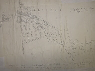
Plan, Ballarat Railway Plan, 1860, 29/05/1860
This plan was created by the Railway Department, Victoria.Photocopy of the Melbourne to Ballarat via Geelong Railway plan. The section is the area adjoining Bakery Hill, Ballarat. The plan shows the Yarrowee River, central Ballarat, Government Camp, Imperial Hotel, Union Hotel, Crown hotel, electric Telegraph line, Eureka Lead, Black Hill Lead, Ballaarat Old Cemetery., Bank of Australasia.ballarat railway, ballarat -
Federation University Historical Collection
Book, New York Post, The School of Mine Quarterly: A Journal of Applied Science, 1889-1809
The School of Mines Quarterly was a jpournal of Applied Science from Columbia College, New York City.The Index to the School of Mines Quarterlu Volumes X1-XX (1900) and 32 green covered journals school of mines, new york, columbia college, schools of mines, columbia school of mines, witwatersrand goldfield, inter-continental railway, mine ropes, harbor improvememnts on the pacific coast, glycerine and artificial butter industry, transit factors for teh columbia college observatory, tables for the reducation of transit observations, ancienct methods for dividing and recoording time in japan, assay of tin, john strong newberry, standards of linnear measure, comparison of costs of electric lighting, huanchaca mine bolivia, el callao gold mine venezuela, john magnus adams, ores in saxony, hartz and rhenish prussia, hofmann apparatus, adjustment of trangulation, determination of carbonic acid in white lead, lower coals in western clearfield county pennsylvania, old telegraph mine ningham canon utah, mechanical preparation of ores, modern waterworks construction, curdling of milk, french regenerative gas furnace, irrication canals, peruvian salt mine, collection of metallurgic dust and fume, permeability of iron and steel, assay of silver, explosion in a zinc fume condenser, teaching archtectural history, liquid air, between the mine and the smelter, ballistic galvonometer, assay of telluride ores, analytical chemistry, theory and design of the masonry arch, silver pick mine wilson colorado, telegraphy and telephoney, mineralogy, morse code, michigan mining practices, titaniferous magnetites, paradox of the pantheon, rocks from wyoming, witwatersrand goldfields, gaseous sun, alternating current distribution, engineering tests on direct current electrical machinery, thomas egleston, ore dressing, frederick morgan watson, camp bird gold mine and mills, magnetic properties of iron and steel, morphology of organic compounds, antimony, structure of the starch molecule, cerrillos hills new mexico, geology, rossie lead veins, practical electrochemistry, lines of graphic statics, anistic acid by the ozidation of anniseed oil, bromate method for antimony, john krom rees, trust company of america building, helion lamp, frederick arthur goetze, mine surveying, pine wood oils, malleable cast iron, electrolytic treatment of galena, turpentine and pine oils, bluestone, ashokan dam bluestone, road resistances, oxy-gas blowtorch, mine dumps, segregation of steel ingots, masonry dam formulas, putnam county magnetic belts, gases, continuity of education, hydraulic diagrams, standardistion of potassium permanganate, sewerage discharge into sea water, modern waterworks, true column formula, slags from lead furnaces, missouri river, tempreture of gases, rocks, architectural history, modern dome, oil machine, undulations in railway tracks, irrigation engineering, cleps-tachymeters, electrical engineering, new york shales, fan pump, sucrose, isaac newton, french school of anstronomers, electrolytic polarization, benjamin bowden lawrence, diamond drilling, new york ciy water front, engineering profession ethics -
 Federation University Historical Collection
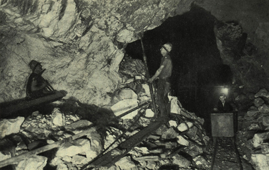
Photograph - black and white, Miners at work underground with a pneumatic drill
Photograph included in book "Victoria: Gold and Minerals" issued by Mines Department Victoria, 1935Photographvictoria, underground drilling, pneumatic drill, rail tracks, hand pushed cart, gold mining, mining, tools -
Federation University Historical Collection
Map, Map of Vitilevu showing vehicular roads, native tracks, villages, provinces, 1935
Printed map on paper backed onto linen with small inset maps of Nandi and Singatoka map, vitilevu, singatoka, nandi -
Federation University Historical Collection
Book, From Timber to Tourism: Exploring Place Attachment and Natural Area Values in the Otway Ranges, 1997
Spiral bound reportuniversity of ballarat, school of business, tourism, apollo bay, otway national park, michelle brown, melinda gill, clare kearns, sarah mcewing, renee walder, cape otway lighthouse, point franklin residential estate, harbour, sand dune erosion, great ocean road, blanket bay, maits rest walking track -
 Australian Commando Association - Victoria
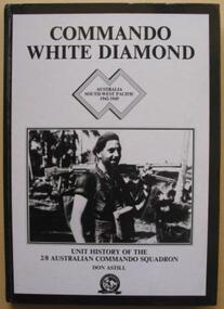
Book, Commando White Diamond: Unt History of the 2/8th Australian Commando Squadron, 1996
The detailed history of the No.8 Independent Commando Company during World War II. Plastic protective cover over the book. The 2/8th Independent Company was formed at Wilson’s Promontory, Victoria, in July 1942 and travelled to Yandina, in Queensland, in September. While the other seven independent companies saw action in the islands off Australian and in New Guinea, the 2/8th spent most of the next two years based at Adelaide River, in the Northern Territory. While it was in the Territory, the independent companies underwent a series of reorganisations and the name of the 2/8th was changed from the 2/8th Independent Company to the 2/8th Cavalry (Commando) Squadron. This name was later simplified to just commando squadron. In July 1944, after years of waiting, the squadron left the Territory and sailed from Townsville to Lae, via Milne Bay. While at Lae, the squadron received an intake of 70 men from the 2/8th from the 2/3rd, 2/5th and 2/6th Cavalry (Commando) Squadrons, many of whom were veterans of the earlier New Guinea campaigns. Their experience was no doubt a useful reserve that would have been called upon during the 2/8th’s subsequent campaign in Bougainville. Others though, were able to implement some of their commando training when a small group from the 2/8th they made a secret landing on New Britain. Towards the end of the 1944 the 5th Division was preparing to make a landing at Jacquinot Bay in New Britain. Part of these preparations included landing a small group of officers from the division at Jacquinot Bay to make a secret reconnaissance of the potential landing site. As Jacquinot Bay was still in Japanese controlled territory, ‘C’ Troop from the 2/8th provided the protection for the reconnaissance party by establishing a position on the beach and by patrolling the surrounding country. Everything went well and the 5th Division later landed at Jacquinot Bay in November. The squadron too was on the move, and in October it sailed to Torokina, the main Australian base on Bougainville, where it joined the II Australian Corps. The campaign on Bougainville was dived into three areas, the Central, Northern and Southern Sectors. The 2/8th served in the latter two areas. The 2/8th made the first move of the Australian campaign in the Northern Sector, by patrolling from Torokina to Kuraio Mission and Amun once a week. The squadron did this from the second week of November unit the second week of December. The 2/8th was then transferred to the Southern Sector. The main battle for Bougainville was fought in the Southern Sector, as the 3rd Division advanced towards Buin – the main Japanese base on the island. As the division’s infantry brigades advanced along the coast, the 2/8th’s task was to protect their flank by conducting forward reconnaissance patrols, harassing the Japanese with raids and ambushes and conducting a form of guerrilla warfare. The squadron had a long campaign. For nine months, from the end of December until August 1945, the troopers were in action the whole time. After securing the Jaba River, they moved inland, first to Sovele Mission, then the villages of Opai, Nihero and Morokaimoro. They had reached Kilipaijino by the end of the war. Each village taken became a patrol base. Patrols were usually limited to two sections, although up to six sections could be operating at a time. Patrols generally lasted four to six days, but nine-day patrols were not unknown. The squadron collected and collated track information, terrain reports and located the enemy. Once patrols had gathered information, they were free to make a ‘strike’ against the Japanese by setting an ambush or taking a prisoner. These raids were very effective, as they forced the Japanese to deploy troops to their rear areas, removing men from the front created by the infantry. Following Japan’s surrender and the end of the war, the ranks of the squadron thinned quickly as men were discharged or were transferred to other units. For those who were left, the squadron returned to Australia at the end of December. In mid January 1946, at Liverpool, the 2/8th Commando Squadron was disbanded.non-fictionThe detailed history of the No.8 Independent Commando Company during World War II. Plastic protective cover over the book. The 2/8th Independent Company was formed at Wilson’s Promontory, Victoria, in July 1942 and travelled to Yandina, in Queensland, in September. While the other seven independent companies saw action in the islands off Australian and in New Guinea, the 2/8th spent most of the next two years based at Adelaide River, in the Northern Territory. While it was in the Territory, the independent companies underwent a series of reorganisations and the name of the 2/8th was changed from the 2/8th Independent Company to the 2/8th Cavalry (Commando) Squadron. This name was later simplified to just commando squadron. In July 1944, after years of waiting, the squadron left the Territory and sailed from Townsville to Lae, via Milne Bay. While at Lae, the squadron received an intake of 70 men from the 2/8th from the 2/3rd, 2/5th and 2/6th Cavalry (Commando) Squadrons, many of whom were veterans of the earlier New Guinea campaigns. Their experience was no doubt a useful reserve that would have been called upon during the 2/8th’s subsequent campaign in Bougainville. Others though, were able to implement some of their commando training when a small group from the 2/8th they made a secret landing on New Britain. Towards the end of the 1944 the 5th Division was preparing to make a landing at Jacquinot Bay in New Britain. Part of these preparations included landing a small group of officers from the division at Jacquinot Bay to make a secret reconnaissance of the potential landing site. As Jacquinot Bay was still in Japanese controlled territory, ‘C’ Troop from the 2/8th provided the protection for the reconnaissance party by establishing a position on the beach and by patrolling the surrounding country. Everything went well and the 5th Division later landed at Jacquinot Bay in November. The squadron too was on the move, and in October it sailed to Torokina, the main Australian base on Bougainville, where it joined the II Australian Corps. The campaign on Bougainville was dived into three areas, the Central, Northern and Southern Sectors. The 2/8th served in the latter two areas. The 2/8th made the first move of the Australian campaign in the Northern Sector, by patrolling from Torokina to Kuraio Mission and Amun once a week. The squadron did this from the second week of November unit the second week of December. The 2/8th was then transferred to the Southern Sector. The main battle for Bougainville was fought in the Southern Sector, as the 3rd Division advanced towards Buin – the main Japanese base on the island. As the division’s infantry brigades advanced along the coast, the 2/8th’s task was to protect their flank by conducting forward reconnaissance patrols, harassing the Japanese with raids and ambushes and conducting a form of guerrilla warfare. The squadron had a long campaign. For nine months, from the end of December until August 1945, the troopers were in action the whole time. After securing the Jaba River, they moved inland, first to Sovele Mission, then the villages of Opai, Nihero and Morokaimoro. They had reached Kilipaijino by the end of the war. Each village taken became a patrol base. Patrols were usually limited to two sections, although up to six sections could be operating at a time. Patrols generally lasted four to six days, but nine-day patrols were not unknown. The squadron collected and collated track information, terrain reports and located the enemy. Once patrols had gathered information, they were free to make a ‘strike’ against the Japanese by setting an ambush or taking a prisoner. These raids were very effective, as they forced the Japanese to deploy troops to their rear areas, removing men from the front created by the infantry. Following Japan’s surrender and the end of the war, the ranks of the squadron thinned quickly as men were discharged or were transferred to other units. For those who were left, the squadron returned to Australia at the end of December. In mid January 1946, at Liverpool, the 2/8th Commando Squadron was disbanded.