Showing 10390 items
matching plan
-
 Bendigo Historical Society Inc.
Map - KOOYOORA, July 23rd 1857
Map: The Township of Kooyoora and suburban allotments in the Parish of Kingower. This plan has been applied to a newer backingmap, township, kooyoora, allotments, parish of kingower -
Bendigo Historical Society Inc.
Map - RESURVEY, PARISH OF SANDHURST, 1/08/1891
Map: Resurvey , Parish of Sandhurst sheet 3. Parish plan ( number 203 in Map Cupboard 1)map, bendigo, parish plan, parish of sandhurst resurvey -
Bendigo Historical Society Inc.
Map - SANDHURST SHEET 1, No date visible
Map: Sandhurst ,County of Bendigo sheet 1. Parish plan ( number 201 in Map Cupboard 1)map, bendigo, city streets, sandhurst -
Bendigo Historical Society Inc.
Map - SANDHURST SHEET 2, No date visible
Map:Sandhurst, County of Bendigo Sheet 2. Parish plan, Eaglehawk. ( number 200 in Map Cupboard 1)map, bendigo, city streets, sandhurst -
Bendigo Historical Society Inc.
Map - LANDS AVAILABLE FOR SELECTION, 6/05/1912
Map: Lands available for selection, County of Bendigo. Parish plan ( number 192 in Map Cupboard 1)map, bendigo, lands available for selection, lands available for selection, bendigo -
Bendigo Historical Society Inc.
Document - MINING PLAN, No date Visible
Mining Plan: Longtitudinal section showing Victoria Quartz Mining Company's Shaft No. 75 to shaft No. 68topic, mining, plans, gold mines bendigo, victoria quartz mining company -
Bendigo Historical Society Inc.
Map - CITY OF SANDHURST RESURVEY SHEET 2, 23/05/1881
Map City of sandhurst Resurvey, sheet 2. Parish plan ( number 231 in Map Cupboard 1)map, bendigo, parish plan, sandhurst resurvey -
Bendigo Historical Society Inc.
Map - CITY OF BENDIGO RESURVEY SHEET 1, 5/06/1903
Map: City of Bendigo resurvet sheet 1. Parish plan ( number 219 in Map Cupboard 1)map, bendigo, parish plan, bendigo resurvey -
Bendigo Historical Society Inc.
Map - CITY OF BENDIGO RESURVEY SHEET NO. 3, Circa 1900
Map: City of Bendigo Resurvey sheet No. 3. Parish plan ( number 214 in Map Cupboard 1)map, bendigo, parish plan, bendigo, resurvey -
Bendigo Historical Society Inc.
Map - PARISHES OF WARRAGAMBA AND MINTO, No date visible
Map: Parishes of Warragamba and Minto,Hand draughted parish plan. (number 290 in map cupboard 1)map, parish plan, warragamba, minto -
Bendigo Historical Society Inc.
Map - KAMAROOKA ALLOTMENTS, 7/06/1894
Map: Parish of Kamarooka Allotments, County of Bendigo. Parish plan (number 288 in map cupboard 1)map, bendigo, allotments, kamarooka, allotments -
Bendigo Historical Society Inc.
Map - NEILBOROUGH, 6/12/1882
Map: Parish of Neilborough, County of Bendigo. Parish plan. Earliest date on map 21/8/1877.map, bendigo, parish plan, neilborough -
Bendigo Historical Society Inc.
Map - BAGSHOT, Circa 1878
Map: Parish of Bagshot, County of Bendigo. Parish plan (coloured) (number 329 in map cupboard 1)map, bendigo, parish plan, bagshot -
Bendigo Historical Society Inc.
Map - GOORNONG, 29/04/1879
Map: Parish of Goornong, County of Bendigo. Parish plan (coloured) (number 326 in map cupboard 1)map, bendigo, parish plan, goornong -
Bendigo Historical Society Inc.
Map - INGLEWOOD, 17/12/1877
Map: Parish of Inglewood, County of Gladstone. Parish plan. Earliest date on map 31/12/75.map, gladstone, parish plan, inglewood -
Clunes Museum
Document - DOCUMENT POSTER, JEANETTE SPITTLE - UNIVERSITY OF MELBOURNE BURNLEY CAMPUS, QUEENS PARK CLUNES - A MANAGEMENT REVIEW
LAMINATED MANAGEMENT REVIEW FOR QUEENS PARK CLUNES. SHOWING MASTER PLAN. COMPLETED 2006. JEANETTE SPITTLEqueens park, clunes, management review, regional botanic gardens -
Lakes Entrance Regional Historical Society (operating as Lakes Entrance History Centre & Museum)
Book, Delbridge Graham R, Freeman Anne, The Church of St Peters by the Lakes, 1976
History of St Peters by the Lakes Paynesville Victoria, acquisition of land, building plans, forward by Bishop Delbridgereligion -
Whitehorse Historical Society Inc.
Pamphlet, Horticultural Centre. Self guided tour, c1985
A leaflet giving a plan of the Horticultural Centre at Forest Hill.A leaflet giving a plan of the Horticultural Centre at Forest Hill. The information in the tour describes the centre and its operation.A leaflet giving a plan of the Horticultural Centre at Forest Hill. horticultural centre, forest hill -
Whitehorse Historical Society Inc.
Pamphlet, Campbell's Croft - Abbey Walk. Design Concept, c1988
A plan showing the design concept for Campbell's Croft and Abbey Walk reserves in Vermont.A plan showing the design concept for Campbell's Croft and Abbey Walk reserves in Vermont. Localities are numbered but there is no key.A plan showing the design concept for Campbell's Croft and Abbey Walk reserves in Vermont.abbey walk, vermont, campbells croft -
Whitehorse Historical Society Inc.
Article, New bid for cinema, 2005
Article on development plans for former quarry site on Middleborough Road for a cinema complex and discount department store.Article on development plans for former quarry site on Middleborough Road for a cinema complex and discount department store.Article on development plans for former quarry site on Middleborough Road for a cinema complex and discount department store.middleborough road, burwood east, reading entertainment australia pty ltd, burwood heights, commercial development, land subdivision -
Whitehorse Historical Society Inc.
Document, Whitehorse Heritage Review 2001, 2003
Part 2 : assessment of precincts. Contract No 02048. Project report, includes 'Proposed heritage overlay plans'.Part 2 : assessment of precincts. Contract No 02048. Project report, includes 'Proposed heritage overlay plans'.Part 2 : assessment of precincts. Contract No 02048. Project report, includes 'Proposed heritage overlay plans'.city of whitehorse, heritage studies, houses, churches, historic buildings -
Whitehorse Historical Society Inc.
Pamphlet, Creating a living environment
Booklet on the guidelines for building, siting and design in residential areas of the City of Nunawading by the City of Nunawading Planning Department.Booklet on the guidelines for building, siting and design in residential areas of the City of Nunawading by the City of Nunawading Planning Department.Booklet on the guidelines for building, siting and design in residential areas of the City of Nunawading by the City of Nunawading Planning Department.town planning, city of nunawading, native plants -
 Whitehorse Historical Society Inc.
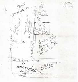
Document, 1924 Tunstall Properties, 11/02/1924 12:00:00 AM
Hand drawn plans of properties bordered by Tunstall (Nunawading) Railway Station,Hand drawn plans of properties bordered by Tunstall (Nunawading) Railway Station, Springvale Road and Springfield Road.Hand drawn plans of properties bordered by Tunstall (Nunawading) Railway Station, plans, whitehorse road, nunawading, tunstall railway station, tunstall avenue, springvale road, springfield road, luxton, lee, mcculloch street, hayes timber, cooper, land subdivision -
Whitehorse Historical Society Inc.
Map, Shire of Blackburn and Mitcham, 1938
Plan of Shire of Blackburn and Mitcham showing sections and lot numbers. Scale 8 chains to 1 inch.Plan of Shire of Blackburn and Mitcham showing sections and lot numbers. Scale 8 chains to 1 inch.Plan of Shire of Blackburn and Mitcham showing sections and lot numbers. Scale 8 chains to 1 inch.shire of blackburn and mitcham, blackburn, blackburn north, blackburn south, burwood east, forest hill, mitcham, nunawading, vermont, vermont south -
Whitehorse Historical Society Inc.
Article, In Line with Policy, 5/01/1993 12:00:00 AM
Abandonment of plans to grade separate Whitehorse and Springvale Roads. Enables Council to redevelop Nunawading Shopping Centre.Abandonment of plans to grade separate Whitehorse and Springvale Roads enables Council to redevelop Nunawading Shopping Centre.Abandonment of plans to grade separate Whitehorse and Springvale Roads. Enables Council to redevelop Nunawading Shopping Centre.freeways, vicroads, victoria. department of planning & housing, city of nunawading -
Whitehorse Historical Society Inc.
Article, Mitcham Road, 1/11/1967 12:00:00 AM
Article on plans for an underpass to replace the Mitcham Rd railway crossing in Nunawading Gazette, 1 November 1967.Article on plans for an underpass to replace the Mitcham Rd railway crossing in Nunawading Gazette, 1 November 1967.Article on plans for an underpass to replace the Mitcham Rd railway crossing in Nunawading Gazette, 1 November 1967.mitcham railway crossing, mitcham road, mitcham, railway crossings -
Whitehorse Historical Society Inc.
Document, Harkaway School, Tally Ho, Harkaway Inn
Plan showing the site of Nunawading national School built by subscription 1859, Harkaway Inn, and surrounding schools.harkaway school, tally ho, harkaway inn, east burwood, schools, hotels, burwood east, wilkinson, henry -
Whitehorse Historical Society Inc.
Document, Advance Blackburn!, c. 1900
Circular letter and street plan regarding donations sought to fund a proposed extension of The Avenue to Blackburn Road.Circular letter and street plan regarding donations sought to fund a proposed extension of The Avenue to Blackburn Road.Circular letter and street plan regarding donations sought to fund a proposed extension of The Avenue to Blackburn Road.blackburn road blackburn, elmore, algernon john, williams, e. g., page, chas. d, the avenue, blackburn -
Whitehorse Historical Society Inc.
Document, Schwerkolt Cottage site management review, 1994
Collection of letters, fliers, plans and Council meeting agenda papers regarding development proposals for Schwerkolt Cottage.Collection of letters, fliers, plans and Council meeting agenda papers regarding development proposals for Schwerkolt Cottage.Collection of letters, fliers, plans and Council meeting agenda papers regarding development proposals for Schwerkolt Cottage.city of nunawading, schwerkolt cottage -
Whitehorse Historical Society Inc.
Article, State park for our border, 2006
City of Whitehorse to have a state-controlled park at its border under a plan for Mullum Mullum Valley.City of Whitehorse to have a state-controlled park at its border under a plan for Mullum Mullum Valley.City of Whitehorse to have a state-controlled park at its border under a plan for Mullum Mullum Valley.city of whitehorse, state parks, mcinnes, ken, falkingham, cecily, friends of mullum mullum valley