Showing 10971 items matching " plan."
-
 Bendigo Historical Society Inc.
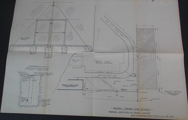
Plan - GOLDEN SQUARE HIGH SCHOOL COLLECTION: PLAN BASKETBALL AND TENNIS COURTS
Golden Square High School proposed basketball and tennis courts site extracted from P.W.D. plan 65-474education, secondary, golden square -
 Bendigo Historical Society Inc.
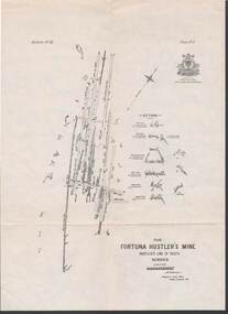
Map - STRUGNELL COLLECTION: HUSTLER'S LINE OF REEFS, BENDIGO, September 1913
Map, Hustler's Line of Reefs, Fortuna Hustler's Mine, Plan, Plate No.11(2).Bulletin No 33 Signed H.A.Whitelaw.Underground Survey Office, Bendigo.map, bendigo, fortuna hustler's mine -
 Bendigo Historical Society Inc.
Document - FORTUNA COLLECTION: BENDIGO FORTUNA VILLA AUCTION
Plan of Fortuna Villa and grounds loose page intended as part of 12th april 2013 Auction Document Cat No 6763.1bendigo, buildings, fortuna villa, bendigo fortuna villa -
 Port Melbourne Historical & Preservation Society
Map - Albert Park, South Melbourne and part of Port Melbourne, MMBW
Melbourne and Metropolitan Board of Works Plan 9E-NE depicting Albert Park, S. Melbourne and (part of) Port Melbourne.mmbw, melbourne and metropolitan board of works -
Port Melbourne Historical & Preservation Society
Plan - Outer berth Passenger Terminal fit-out, Station Pier, PMA, P B Keighran, Port of Melbourne Authority, 1987
Port of Melbourne Authority revised floor and section plans for Station Pier Outer Berth passenger Terminal Fit-out.piers and wharves - station pier -
Port Melbourne Historical & Preservation Society
Plan - Upper Bay Street, annotated by Marilyn Allport showing names of various residents, mid 20th C, Marilyn Allport
Marilyn Allport annotated plan of upper Bay St area showing names of various residents in mid 20th centurynotations are in pencilbuilt environment - domestic, built environment - commercial, industry, families, war - world war ii, marilyn allport, max allport, janet bolitho -
Port Melbourne Historical & Preservation Society
Plan - Toll bar, house and closet, Sandridge, Charles Clay?, Borough Surveyor, 1860s - 1870s
Plan and elevation for Borough of Sandridge toll bar, house and closet, hand drawn and coloured 1860s-70s. Master copy.Signed by Chas. Clay, Suveyor and John L. Forrester (?) and witnessed bt Thomas R. Warren (?).built environment - civic, charles clay, thomas peek warren, john l forrester -
Port Melbourne Historical & Preservation Society
Plan, 1870s
Unidentified, undated plans believed to be for the Market shed, market site (ref Turnbull/U'ren pp 102-9, 132)engineering department - borough of sandridge, market reserve -
Port Melbourne Historical & Preservation Society
Plan - Williamstown Road from Salmon Street to Prohasky Street, Engineering Department, Town of Port Melbourne, 1893 - 1919
Plan of Williamstown Road (Reconstruction of pitched portion). From Salmon Street to Prohasky Street. 1893 Loan Number 5.Reverse side - Williamstown Road, west of Salmon (Pitcher Construction).engineering - roads streets lanes and footpaths -
Port Melbourne Historical & Preservation Society
Map - Melbourne and suburbs, MMBW, 8 Dec 1909
MMBW map of Melbourne and suburbs - Record plan up to July 1st 1913 (scale 3/4" = 1 mile)engineering - board of works, calder e oliver, russwaul(?) -
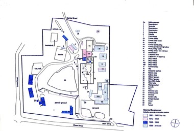
NMIT (Northern Melbourne Institute of TAFE)
Report: Visual and Performing Arts Centre: concept proposal NMCOT 1990
A4 size bound report with clear plastic cover. Text covers 26 pages plus plans, tables, images.northern metropolitan college of tafe, reports, nmit -
 Bendigo Historical Society Inc.
Document - MCCOLL, RANKIN AND STANISTREET COLLECTION: NORTH MONUMENT
Documents: Manilla folder - Plan of area applied for on lease No. 10023 Ben. Prospectus of the Monument Hill Gold Mining Company.MCCOLL RANKIN & STANISTREETorganization, business, gold mining lease, mccoll rankin & stanistreet -
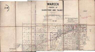 Bendigo Historical Society Inc.
Map - JACK FLYNN COLLECTION: WAREEK, Examined 1918
Map: L.1053. Parish of Wareek, Counties of Gladstone and Talbot. Parish plan. Looks like half of the sheet is missing.Second Issue. Examined by S.F. Green. July 1918. William J. Swan, Draughtsman, August 1884. Photo-Lithographic Fac-Simile, W 36.map, gladstone, parish plan, wareek -
Bendigo Historical Society Inc.
Map - PART PARISHES OF SANDHURST MARONG AND NERRING, No date visible
Map: Section of a Parish plan of Bendigo, covering Ironbark, Eaglehawk and Myers Flat ( number 145 in Map Cupboard 1)map, bendigo, city streets, parish of sandhurst, parish of marong, parish of nerring, ironbark, eaglehawk, myers flat -
Bendigo Historical Society Inc.
Map - BENDIGO IRRIGATION SETTLEMENT, 12/02/1908
Map: Plan of Bendigo Irrigation Settlement, Parishes of Sandhurst and Wellsford, County of Bendigo ( number 160 in Map Cupboard 1)map, bendigo, irrigation settlement, bendigo irrigation settlement, parishes of sandhurst and wellsford, county of bendigo -
Bendigo Historical Society Inc.
Map - TOWNSHIP OF KANGAROO FLAT, 27/01/1932
Map: Township of Kangaroo flat, Parish of Sandhurst , County of Bendigo. Parish plan ( number 194 in Map Cupboard 1)map, bendigo, township, kangaroo flat -
Bendigo Historical Society Inc.
Map - BOROUGH OF EAGLEHAWK, 30/11/1931
Map: Borough of Eagle hawk, Parish of Nerring. Parish plan with coloured areas ( number 185 in Map Cupboard 1)map, bendigo, parish plan, borough of eaglehawk, parish of nerring -
Bendigo Historical Society Inc.
Map - TARNAGULLA (PARTS), Circa 1880's
Map: Compilation of 3 hand draughted parish plans showing portions of Tarnagulla (number 261 in map cupboard 1)map, parish plan, tarnagulla -
Bendigo Historical Society Inc.
Map - TOWNSHIP OF HEATHCOTE (PART), 11/04/1935
Map: Township of Heathcote (part), Parish of Heathcote, County of Dalhousie. Parish plan (number 259 in map cupboard 1)map, dalhousie, township, heathcote, copunty of dalhousie -
Bendigo Historical Society Inc.
Map - HUNTLY (PART) RESURVEY, Circa 1877
Map: Huntly [part) resurvey, Parish of Huntly, County of Bendigo. Parish plan ( number 243 in Map Cupboard 1)map, bendigo, parish plan, huntly -
Bendigo Historical Society Inc.
Map - PARISH OF EPPALOCK RESURVEY, 23/05/1876
Map: Parish of Eppalock resurvey, County of Bendigo, hand draughted Parish plan ( number 240 in Map Cupboard 1)map, bendigo, parish plan, eppalock, resurvey -
Bendigo Historical Society Inc.
Map - SANDHURST (PART), Circa 1880's
Map: Parish plan showing the area Specimen Hill Road and Inglewood St. ( number 222 in Map Cupboard 1)map, bendigo, parish plan, specimen hill rd. inglewood st. -
 Bendigo Historical Society Inc.
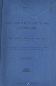
Book - ANNUAL REPORT OF THE SECRETARY FOR MINES AND WATER SUPPLY, c1886
Annual Report Of The Secretary For Mines And Water Supply, Victoria. Publisher: Government Printer, Melbourne. 122 pages. Plans & drawings.victoria, mines and water supply, mining machinery, mine safety, mining statistics, regulation inspection 1885 -
Bendigo Historical Society Inc.
Map - WESTON, 21/10/1876
Map: Re-Survey of part of the parish of Weston, County of Rodney. Parish plan (number 309 in map cupboard 1)Murray and Hargreave, Authorised surveyorsmap, rodney, parish plan, parish of weston, murray and hargreave -
Bendigo Historical Society Inc.
Map - BENDIGO, October 1st 1893
Map: Plan of the whole County of Bendigo, Showing areas now available for Selection (number 340 in map cupboard 1)map, bendigo, lands for selection, county of bendigo, areas available for selection -
Bendigo Historical Society Inc.
Map - GRAZING ALLOTMENTS, 15/10/1894
Map: Grazing Allotments, Parishes of Whirrakee and Bagshot, County of Bendigo. Parish plan (number 331 in map cupboard 1)map, bendigo, grazing allotments, grazing allotments, whirrakee, bagshot -
Tatura Irrigation & Wartime Camps Museum
Sketch, Carl Kubler, 1937
Brown wooden framed, blue/grey mat, pencil drawing of plan of Sarona featuring streets and houses, fields and plantations.Sarona Deutsche Kalone Jaffa Palaestine Januar 1937 Prod Von Carl Kublercarl kubler, camp internee sketches, sarona palestine, magdalen kubler -
University of Melbourne, Burnley Campus Archives
Document, Ellis Stones, 1999-2000
Notes, correspondence and plan re Ellis Stones and on FOBG winning award to restore Ellis Stones dry water courseellis stones, fobg -
 Stawell Historical Society Inc
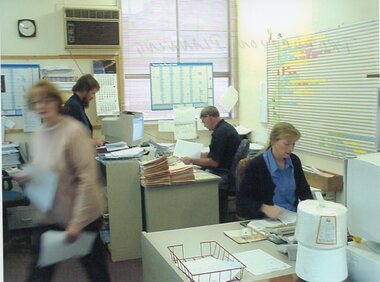
Photograph - Aunde Album 29, Production Planning, 2002
Aunde / Norwellan Textiles North Western Woolen Mills became Norwellan Textiles then AUNDEColour landscape photo: Office, 2 Women, 2 Men, planning calanders, file, computers, clock 1.50 PM.AUnde Australia Ltd. logoindustry, aunde -
Stawell Historical Society Inc
Map, Underground Mine Workings Stawell, 1894
Plan and Elevations of mine workings 12 September 1894. J H Bate Mining Surveyor. Framed under Glassstawell, mining, plans