Showing 11112 items
matching planning
-
 Port Melbourne Historical & Preservation Society
Plan - Handcoloured location of Libbis family members' homes on copy of a section of 1894 MMBW map, 1894
Obtained from MMBW by Peter LIBBIS when researching Libbis family historyPhotocopy of a section of 1894 MMBW plan 118 which has been handcoloured to indicate locations such as homes of various Libbis family membershandcoloured to indicate locations such as homes of various Libbis family membersbuilt environment, families, peter libbis -
Port Melbourne Historical & Preservation Society
Plan - Handcoloured location of Libbis family members' homes on copy of a section of 1894 MMBW map, 1894
Obtained from MMBW by Peter LIBBIS when researching Libbis family historyPhotocopy of a section of 1894 MMBW plan 118 which has been handcoloured to indicate locations such as homes of various Libbis family membershandcoloured to indicate locations such as homes of various Libbis family membersbuilt environment, families, peter libbis -
 University of Melbourne, Burnley Campus Archives
Plan, Old Caretakers Cottage: Base Plan 1:100, 198-?
1. Tracing paper and paper plans of Old Cottage and surroundings. Scale 1:100. 2. Tracing paper copy of Caretaker's residence.cottage, caretaker, burnley, vcah -
Whitehorse Historical Society Inc.
Article, New team, 1991
he new management team at Nunawading Swimming Pool plans to introduce a range of programs to encourage family participation. New manager - Dean Rattle.The new management team at Nunawading Swimming Pool plans to introduce a range of programs to encourage family participation. New manager - Dean Rattle.he new management team at Nunawading Swimming Pool plans to introduce a range of programs to encourage family participation. New manager - Dean Rattle.swimming, nunawading swimming pool, rattle, dean, stephenson, graeme, clements, julie, portelli, sue, nunawading memorial swimming pool, nunawading pool, aqualink nunawading -
Lakes Entrance Historical Society
Book, Strategy Steering Committee, East Gippsland Shire Draft Strategy Mar 1997, 1997
The draft stategy plan provided a basic for discussion with the community about goals and future directions for the next 15 years for East Gippsland Victoriahouses, environment -
Lakes Entrance Historical Society
Book, LERHS, East Gippsland Rail Trail, 2015c
Display folder containing newspaper clippings leaflets and other information on the planning and completion of the East Gippsland rail trail. Lakes Entrance Victoriatransport, recreation -
Lakes Entrance Historical Society
Book, Gippsland Coastal Board, Gippsland Regional Coastline Plan 2015 - 2020, 2015
Booklet containing the draft plan of managing the Gippsland coastal region respecting the social economic and enviromental values for residents and visitors to Gippsland Victoriawaterways, tourism, environment -
Stawell Historical Society Inc
Map - Picture, Plan of Mining Leaseholders and of Land Applies for under Mining Lease November 1887. Plus photocopy, 1887
Lists Businesses in Stawell Trade Directory Mines Listed. New Darlington Mine, Moonlight Junction, Magdala Extended, Moonlight Consols, North Magdala Moonlight, Magdala No 1,Pioneer & Galatea, Pleasant Creek Cross Reef, Moonlight, Moonlight Extended, Oriental, Cross Reef Consolidated, Sloanes and Scotchmans, Scotchmans United, Scotchmans & Cross Reefs,, New Perthshire, Federal, Wimmera Wonga And Birmingham, Rutlands, Wonga ExtendedFramed Stawell Trade Directory 1887 and Plan of Mining Leaseholders and of Land Applies for under Mining Lease November 1887. Plus photocopy.W C Bates Mining Surveyor 4.11.87stawell -
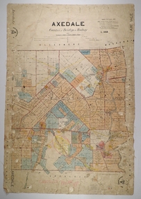 Bendigo Historical Society Inc.
Map - AXEDALE, 26/07/1877
Map: Axedale, Counties of Bendigo and Rodney. Parish plan Draughtsman E. Daniell Sept. 1876. Examined by Harvey 1/6/1877map, bendigo, parish plan, axedale, e. daniell, harvey -
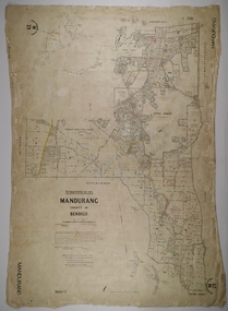 Bendigo Historical Society Inc.
Map - MANDURANG 3, 10/11/1909
Map: Mandurang, County of Bendigo. Parish plan Examined by W. S. Stephen 11.12.79 W. E. Porter Draughtsman July 1879map, bendigo, parish plan, mandurang, w. s. stephen, w. e. porter -
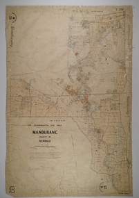 Bendigo Historical Society Inc.
Map - MANDURANG 2, Date unreadable
Map: Mandurang, County of Bendigo. Parish plan Examined by W. S. Stephen 11.12.79 W. E. Porter Draughtsman July 1879map, bendigo, parish plan, mandurang, w.s. stephen, w. e. porter -
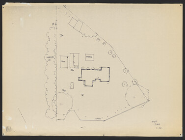
Port Melbourne Historical & Preservation Society
Plan - Proposed Beacon Cove Development plan by Sandridge City Development Company Pty Ltd, 17 July 1989
A photocopy of a detailed of areas 3,4,11,12, 5c, 5b & 5c of the plan for Beacon Cove from the Sandridge City Development Company Pty Ltd.sandridge city development company pty ltd, local government - city of port melbourne, beacon cove -
Port Melbourne Historical & Preservation Society
Book - Heritage study, former Temperance Hall, Port Melbourne, Jan 2008
Completed by donor as part of the requirements for the subject "Heritage Planning" at RMIT University for the degree of Master of Social Science (Environment and Planning)Heritage study of the former Temperance Hall, including a study of selected comparative buildings in the locality. White 86 page book with clear and red plastic cover/binding. January 2008social activities, town planning, heritage, port melbourne dispensary, the independent order of rechabites, port melbourne temperance hall, built environment - civic, robyn clinch -
Bendigo Historical Society Inc.
Map - HUSTLER'S REEF & HUSTLER'S REEF NO 1 MINES - PLAN OF THE HUSTLER'S REEF & HUSTLER'S REEF NO 1 MINES
Plan of the Hustler's Reef & Hustler's Reef No 1 Mines on the Hustler's Line of Reefs Bulletin No 33, Plate No XV. Plan shows the two mines with depth of levels, geological features and levels in relation to the shaft. Geological Survey of Victoria emblem and signed by H A Whitelaw, Underground Survey Office Bendigo, September 1913. Note - The Lease Boundaries shown on this plan are only in their approximate relative positions to Nos 13, Intermediate and 14 Levels of the Hustler's Reef No 1 workings, and Nos 15, 16 and 17 Levels of the Hustler's Reef workings.mining, parish map, hustler's reef & hustler's reef no 1 mines, plan of the hustler's reef & hustler's reef no 1 mines, geological survey of victoria, underground survey office bendigo, h a whitelaw, hustler's line of reefs -
Bendigo Historical Society Inc.
Map - CAMPBELL COLLECTION: BENDIGO AND DISTRICT MAPS, 1982
Map. Forest Commission Victoria, Bendigo Forest District, Sub-Plan 1 District Fire Prevention Plan, Greater Bendigo Area. Prevention Strategy Plan. Shire of Marong, Shire of Huntly, Borough of Eaglehawk, Shire of Strathfieldsaye, Sailors Gully, Epsom, Jackass Flat, White Hills, California Gully, Maiden Gully, Long Gully, North Bendigo, City of Bendigo, Bendigo East, Kennington, West Bendigo, Golden Square, Quarry Hill, Flora Hill, Spring Gully, Kangaroo Flat.Base prepared 1982. (number 397 in map cupboard 1)map, bendigo, forest district -
 Bendigo Historical Society Inc.
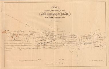
Document - MARKS COLLECTION: ABE LINCOLN CO LEASE
Two copies of plan for Abe Lincoln Co. Lease, New Chum, Sandhurst. One original, one copy. On top of plan 'Plan Showing Position of the Abe Lincoln Co. Lease, New Chum, Sandhurst' under name 'by H.B. Nicholas, Mining Surveyor' Sheepshead Reef, Easter reef, Alfred Reef, Allingham Reef,Adventure Reef, Belle Vue Reef, New Chum Reef, Black Lead, Victoria Reef lines shown on map with mine leases marked. On bottom of map 'Monument Hill Reef' line marked.bendigo, mining, abe lincoln lease -
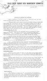 Falls Creek Historical Society
Document - Circular - To Lessees and Licensees
Bob (Herman) Hymans (a former member of the Royal Netherlands Navy) was born in Bloemendaal, Holland on 30th September 1922. During World War II he fought against the Japanese in the Dutch East Indies (now Indonesia) and was imprisoned in Changi and on the Burma Railway. After gaining qualifications as a Ski Instructor, Bob arrived in Falls Creek in July 1950. Working as an Instructor and Supervisor at Bogong Lodge, Bob decided his future was in accommodation. He was successful in negotiating an indenture for land from the State Electricity Commission (SEC). It took Bob two years to build his Grand Coeur Chalet but, tragically, it was burned down in August 1961. Bob also built the first Chairlift in Australia. This was a single chairlift and the structure was built from wooden electricity poles. He was constantly full of new ideas and proposals for the village. Bob Hymans died on 7th July 2007. This Collection of documents and letters tells the story of Bob's endeavours to develop Falls Creek into the ski village it is today.This item is significant because it documents actions taken by the Falls Creek Tourist Area Management Committee in their role overseeing the Tourist Area.A circular from the Management Committee summarising the 1970 season and plans for future development. This included further plans for slope improvements and medical services in Fall Creek Reference is also made to the need for positive public relations. Developments planned for the ski tows were outlined. Prices for lifts and tows for the 1971 season were included. Information for a clean up and oversnow transport were mentioned. Extension of the Village and internal improvements also necessitated sealing of roads. The predicted cost for this was $200,000. A full list of Committee Members finished off the circular.falls creek tourist area management committee, falls creek administration, bob hymans -
Stawell Historical Society Inc
Map - Drawings, Wendy Jacobs, Western Highway, 2014
WD 1/13 - Site Plan WD 2/13 - Existing Conditions & Demolition Plan WD 3/13 - Floor Plan WD 4/13 - Elevations WD 5/13 - Sections AA & BB WD 6/13 - Sections CC WD 7/13 - Sections DD, EE & FF WD 9/13 - Roof Plan WD 10 /13 Reflected Ceiling Plan WD 12/13 - Toilet & Meeting Cup'd Details WD 13/13 - DetailsEleven (11) A1 Printed MapsWendy Jacobs Architect & Heritage Consultant Nov 2014 -
 Kew Historical Society Inc
Plan - Subdivision Plan, Jaques Estate, 1927
The Kew Historical Society collection includes almost 100 subdivision plans pertaining to suburbs of the City of Melbourne. Most of these are of Kew, Kew East or Studley Park, although a smaller number are plans of Camberwell, Deepdene, Balwyn and Hawthorn. It is believed that the majority of the plans were gifted to the Society by persons connected with the real estate firm - J. R. Mathers and McMillan, 136 Cotham Road, Kew. The Plans in the collection are rarely in pristine form, being working plans on which the agent would write notes and record lots sold and the prices of these. The subdivision plans are historically significant examples of the growth of urban Melbourne from the beginning of the 20th Century up until the 1980s. A number of the plans are double-sided and often include a photograph on the reverse. A number of the latter are by noted photographers such as J.E. Barnes.The Jaques Estate was a small subdivision of eight residential allotments bordering Jaques Street and Barkers Road in what is now Hawthorn East. Advertised in The Argus as being in ‘Upper Hawthorn’ the subdivision was claimed to include: ‘charming villa sites in excellent situations, with every convenience available, and with superior homes surrounding’.subdivision plans - hawthorn, jaques estate -
Glen Eira Historical Society
Document - SHELFORD GIRLS’ SCHOOL AND KINDERGARTEN
This file contains 2 items relating to plans for the buildings and grounds of the school: 1/2 copies (1photocopy, 1 original) of the July 1982 ‘Shelford Planning Brief: Church of England Girls’ Grammar School’, written by the Caulfield City Council. The brief describes the history of the school, its current grounds and plans for future expansion. It also contains 2 ground plans: one of the existing school site and 1 of the planned future school site. 2/1 copy of a City of Caulfield Council memo regarding the July 1982 Shelford Planning Brief, describing small changes to the brief. Written by J. Floyd, 24/11/1982.city of caulfield, shelford c.e.g.g.s., caulfield, glen eira road, st mary’s anglican church, seymour road, allison road, ‘helenslea’, hood justice mr, hood crescent, st mary’s parish hall, helenslea road, education, gymnasiums, schools, students, secondary schools, primary schools, bentleigh, classrooms, car parks, libraries, traffic, playgrounds, teachers, windows, plans, shelford planning brief, kilvington planning brief, shelford church of england girls’ grammar school, floyd j, fences, kilvington baptist girls’ -
 Bendigo Historical Society Inc.
Document - JOAN LEVERSHA COLLECTION: HOUSE PLANS 12 BOLT STREET, LONG GULLY
Various documents relating to the plan building of house at 12 Bolt Street, Long Gully. 1)Plan of proposed residence at Bolt Street, Long Gully for D. Dean Esq. job No. 133R plan drawn by A.S. and R.A. Eggleston Architects, 186 Mitchell Street, Bendigo. Stamp of the City of Bendigo approving the plan, signed by an official and dated 27/07/1950. 2) inside plan drawn in pencil and blue Biro, stamped by City of Bendigo and Bendigo Sewerage Authority. 3) Another drawing of section done in blue Biro. 4) Application for permit to construct No.4746. 5) Two pages on A4 paper written in blue pen, under the title City of Bendigo information for builders in regard to weatherboard buildings, long list of regulations to be followed, stamp of City of Bendigo and signature of D. Dean dated 27/07/1950. 6) small paper with various dimensions. All this documents are in a paper envelope marked Doug, house, 12 Bolt St.house, private, drawings -
 Kew Historical Society Inc
Plan - Subdivision Plan, J R Mathers & McMillan, Clutha Subdivision, 1940
Pru Sanderson, in her groundbreaking ‘City of Kew Urban Conservation Study : Volume 2 - Development History’ (1988), summarised the periods of urban development and subdivisions of land in Kew. The periods that she identified included 1845-1880, 1880-1893, 1893-1921, 1921-1933, 1933-1943, and Post-War Development. These periods were selected as they represented periods of rapid growth or decline in urban development. An obvious starting point for Sanderson’s groupings involved population growth and the associated economic cycles. These cycles also highlighted urban expansion onto land that was predominantly rural, although in other cases it represented the decline and breakup of large estates. A number of the plans in the Kew Historical Society’s collection can also be found in other collections, such as those of the State Library of Victoria and the Boroondara Library Service. A number are however unique to the collection.The Kew Historical Society collection includes almost 100 subdivision plans pertaining to suburbs of the City of Melbourne. Most of these are of Kew, Kew East or Studley Park, although a smaller number are plans of Camberwell, Deepdene, Balwyn and Hawthorn. It is believed that the majority of the plans were gifted to the Society by persons connected with the real estate firm - J. R. Mathers and McMillan, 136 Cotham Road, Kew. The Plans in the collection are rarely in pristine form, being working plans on which the agent would write notes and record lots sold and the prices of these. The subdivision plans are historically significant examples of the growth of urban Melbourne from the beginning of the 20th Century up until the 1980s. A number of the plans are double-sided and often include a photograph on the reverse. A number of the latter are by noted photographers such as J.E. Barnes.The subdivision plan for the Clutha Subdivision is one of the largest in the Society’s collection. The plan includes a map of the proposed allotments, photographic views to the north and south, and information about the kinds of buildings that could be constructed on the allotments. The subdivision was bounded by Studley Park Road, and Carson, Stevenson and Edgecombe Streets. Two new streets, Mackie Court and Younger Street were created as part of the subdivision. The subdivision took its name from ‘Clutha’, the home of John Carson, who was to become Mayor of Kew in 1863. A Report to the City of Boroondara outlined how: ‘The Clutha estate was progressively developed from 1940, with new houses under construction on the Studley Park Road, Carson and Edgecombe Street frontages by 1941. By 1943, directory listings were available for all addresses with the exception of Mackie Court. Building ceased after the government’s prohibition on civilian building was enforced from 1942, with little change in listings until the 1950s when the remainder of the subdivision was developed’."H"subdivisions - kew - studley park, clutha subdivision, studley park road -
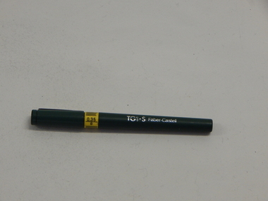 Wannon Water
Technical Drawing Pen, A.W Faber-Castell (Australia) Pty Ltd
Used by Engineers for hand drawing plans. Used during 1980's. Hand drawing of plans was required prior to the use of digital plotters.TG1.S Technical Drawing Pen with 0.35 Thickness PointTG1.S -
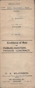 Bendigo Historical Society Inc.
Document - H.A. & S.R. WILKINSON COLLECTION: CONTRACT OF SALE
Conditions of sale by private contract dated 11th September, 1930 between J. Beercroft (seller) and J. Smith (buyer) for pieces of land outlined in red on the plan hereon and owned and or occupied by the vendor at Epsom, being part of allotments 2, 3 and 4 section 8 in the Parish of Huntly. Price 200 pounds. Attached plan of the land sold.organization, business, h.a. & s.r wilkinson real estate -
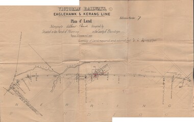 Bendigo Historical Society Inc.
Document - BUSH COLLECTION: PLANS PERTAINING TO LAND OF S. A. BUSH
A: Plan of subdivision of Allots 6, 7, 8, 15 & 16, Sec. 62C, City of Bendigo (The Property of Albert Bush, Esq.) - Plan is torn in half forming two pieces (see 'Condition'. Pinned note attached to one piece. B: Victoria Railways, Eaglehawk & Kerang Line (Albert Bush land, Parish of Nerring, County of Bendigo.person, individual, bush collection - personal -
Bendigo Historical Society Inc.
Map - NEW CHUM & VICTORIA LINES OF REEF - PLAN OF NEW CHUM & VICTORIA LINES OF REEF
Two pages of a Plan of New Chum & Victoria Lines of Reef, compiled by G. W. Hart. Taken from J. N. Macartney's G'Fields Registry for 1871. Plan shows leases from High Street to California Gully. Location of the Manchester Arms, British & American Hotel and the Quartz Miners Arms are shown. Townships of Long Gully and Ironbark are shown.map, goldfields, new chum & victoria lines of reef, plan of new chum & victoria lines of reef, victoria catharine g m coy, thornton & co, extd victoria reef g m co, ural tribute compy, nil desperandum compy, koch, north victoria g m co, danger hill coy, north endeavour coy, wheadon & co, pilot co, north energetic co, energetic compy, endeavour company, hercules co, victoria gold mines compy, iron duke g m co, golden fleece united, ballerstedt, alfred co, confidence co, prince alfred co, canterbury co, advance co, wells, humboldt co, adventure co, try me well, sterry & co, gibbs & ballerstedt, handy andy, wells?, south adventure co, w rae, victoria reef quartz m co, myra co, jackson, wybrants, burrows & sterry, new chum & victoria tribute, old chum co, ballerstedt, lazarus, watson, koch & hildebrand, lansell & hunt, dennis, abe lincoln co, bonati & co, ellesmere co, moore late menzies, british co, british tribute co, garibaldi, c c co, new chum trib, dobson & co, young chum co, little chum co, old chum co, new chum trib, little chum trib, g w hart, j n macartney's g'fields registry for 1871, manchester arms, british & american, quartz miners arms -
Bendigo Historical Society Inc.
Map - UNITED HUSTLER'S & REDAN & K. K. MINES - PLAN OF UNITED HUSTLER'S & REDAN & K. K. MINES
Plan of the United Hustler's & Redan & K. K. Mines on the Hustler's Line of Reefs Bulletin No 33 Plate No XXVIII. Plan shows depth of levels, stone encountered and some geological features. Geological Survey of Victoria emblem and signed by H S Whitelaw, Underground Survey Office Bendigo, September 1913. This item has not been scanned or photographed.mining, parish map, united hustler's & redan & k. k. mines, united hustler's and redan shaft, k. k. shaft, h s whitelaw -
 Bendigo Historical Society Inc.
Document - CENTRAL DEBORAH GOLD MINE - PLAN OF CHANGING HOUSE
Hand drawn plan for Changing House for Central Deborah G. M. Co. Bendigo. Drawn by A. Richardson 14/11/1971. Drawing has approx. measurements and is not drawn to scale. Also some Central Deborah Gold Mine Information . Ref. Mines Dept. Surface Plan 15/1/1954. Written by A Richardson 14/12/1971.mine, gold, central deborah gold mine, central deborah gold mine, plan of changing house, a richardson, mines dept. surface plan 15/1/1954