Showing 7339 items
matching shopping
-
 Glen Eira Historical Society
Letter - International Diabetes Institute, Kooyong Road, 260, Caulfield
This file contains 1 item: 1/A letter and flier addressed to the Caulfield Historical Society, from Evelyn Alperstein of the International Diabetes Institute 13/02/1997 requesting volunteers for their opportunity shops in Caulfield South and Elsternwick.caulfield historical society, international diabetes institute, kooyong road, elsternwick, caulfield south, alperstein evelyn, campbell f. mrs., charitable organisations, voluntary workers, caulfield -
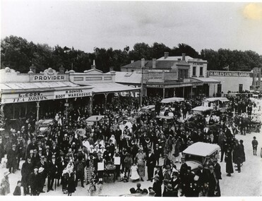 Clunes Museum
Photograph, c1920
Image shows looking east along Fraser Street, showing shops, including L. Cook Tearooms, M. Downes Boot Warehouse, Cash Draper, 4 Miles Central Garage, F C Henry, Barnetts.1 Black and white photograph of Fraser Street Clunes after a parade c1920, street is filled with people celebrating .2 Larger reproduction of the above photograph in black and white.1 £4.00parade, fraser street, 1920, l cook tearooms, m downes boot warehouse, cash drapery, h miles central garage, f c henry, barnetts -
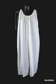 Whitehorse Historical Society Inc.
Clothing - Negligee Set, 1966
Worn as part of her trousseau by Rosalie Whalen on her honeymoon after her wedding on 1st June 1966 at St Andrews Presbyterian Church, Gardiner, Vic.|Bought at a shop at the top of Collins Street 'The Paris End'.Rosalie is the great great grand-daughter of Johann August Schwerkolt, pioneer of Mitcham.1. 1966 white sleeveless batiste nightgown with salmon pink silk Rouleau ties on shoulders. The armholes and neckline are edged with the salmon silk. 2. The elbow-length sleeved coat has a gathered neckline edged with salmon pink Rouleau and tied at the opening (which does not have any fastenings). The sleeves are raglan with elastic casing and decorated with a salmon pink bow. See also wedding dress NA4579 and hat NA4597.costume, female nightwear -
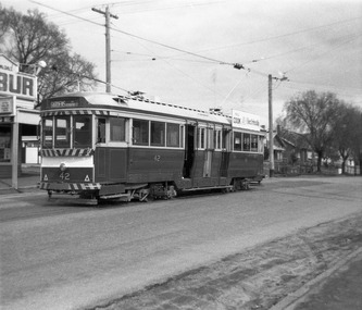 Ballarat Tramway Museum
Photograph - Digital Image, Peter Knife, SEC 42 at the Mt Pleasant terminus, 14/8/1965
Digital image of SEC 42 at the Mt Pleasant terminus. The tram has the destination of Gardens via Drummond St Nth. In the background is the Milk bar/shop that was located at the terminus. Photo by Peter Knife 14 Aug 1965.Yields information about Ballarat's trams in August 1965.Digital image of a black and white negativetramways, tramcars, ballarat, mt pleasant, tram 42 -
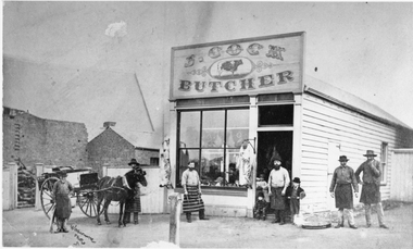 Stawell Historical Society Inc
Photograph, Mr J Cocks wooden Butchers Shop in Main Street Stawell on West side of Town Hall
Wooden Butcher’s Shop (J. Cock) Main Street Stawell on West side of Town Hall with butchers wearing aprons and horse drawn cart out front. Note sheep carcases hanging out in open air.stawell business -
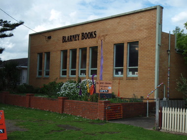 Port Fairy Historical Society Museum and Archives
Photograph
this building was built to house the Port Fairy Masonic Lodge No 67 with two seperate large spaces a general l meeting room in the front and the formal Lodge space to the rear. it is now occupied as a book shop by ‘Blarney Books’Coloured photograph of brick fronted building housing Blarney Booksshop, commercial, port fairy masonic lodge no.67, blarney books, books -
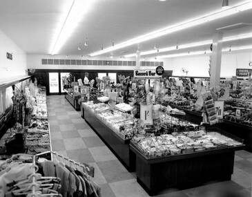 City of Kingston
Photograph - Black and white, c. 1956
This photograph depicts the interior of the Coles Variety Store within Bentleigh's Centre Road shopping precinct in 1956. Signage represents the pre decimal currency era. The Record Bar advertises the availability of standard and microgroove vinyl records.In this era, the Centre Road Bentleigh shopping strip provided consumers with access to many of the major retail outlets and provided for a wide range of shopping needs. By the 1960s, Chadstone Shopping Centres (opened 1960) and Southland (opened 1968) had been established which created changes to the way in which people shopped.Black and white photograph of interior of Coles Store in Centre Road, Bentleigh displaying prominent signage predating decimal currency. Other signage includes the Coles Record Bar indicating the sale of standard and microgroove vinyl records.Handwritten in blue ink: Coles Bentleigh Sep 1956 B Black printed text on white round adhesive sticker: 202 Handwritten in red ink: 80%shopping strip, strip shopping, bentleigh, city of moorabbin, coles stores -
 City of Kingston
Photograph - Black and white, 20 December 1945
This aerial photograph depicts the changing landscape of Cheltenham and Highett since WWII. Photographed in 1945, there is a mix of urban dwellings and industrial development and precedes the major transformation of Cheltenham with the development of the Southland shopping centre in the 1960s and expansion in the 1990s.A large part of Cheltenham was originally established as a rural market gardening community. The railway line and station brought urban development to the area and in the north, the Highett area was dominated by the Highett Gas Works. Cheltenham became a major destination for shopping in the 1960s with the opening of Southland.Aerial photograph taken in 1945 of Cheltenham and Highett within the City of Kingston. The image includes the Highett Reserve, (top right), the Methodist Children Homes (now Southland), Nepean Highway and Jamieson Street. Highett Gas Works is visible in the top left and the land now named William Fry Reserve at the intersection of Bay Road and Nepean Highway. A visible large parcel of land on the corner of Bay Road and Nepean Highway was developed in the 1990s as the west side addition to Southland. The densely vegetated area in the upper right sector of the image is now dense with housing. Tulip Grove, Heather Grove and Gilford Street are visible bottom left. This image is possibly from the collection of aerial photographs commissioned by the Department of Crown Lands and Survey and taken by Adastra Airways.Black ink: 57252 White lettering: VIC-10 57252 20.12.45 [lens information indecipherable] PROJ. No.5 MELB. METROP AREA Black pencil: 80highett, cheltenham, highett gas works, urbanisation -
 City of Kingston
Photograph - Black and white, 20 December 1945
This aerial photograph depicts the changing landscape of Cheltenham and Highett since WWII. Photographed in 1945, there is a mix of urban dwellings and industrial development and precedes the major transformation of Cheltenham with the development of the Southland shopping centre in the 1960s and expansion in the 1990s.A large part of Cheltenham was originally established as a rural market gardening community. The railway line and station brought urban development to the area and in the north, the Highett area was dominated by the Highett Gas Works. Cheltenham became a major destination for shopping in the 1960s with the opening of Southland.Aerial photograph taken in 1945 of Cheltenham and Highett within the City of Kingston. The image includes the Highett Reserve, (top right), the Methodist Children Homes (now Southland), Nepean Highway and Jamieson Street. Highett Gas Works is visible in the top left and the land now named William Fry Reserve at the intersection of Bay Road and Nepean Highway. A visible large parcel of land on the corner of Bay Road and Nepean Highway was developed in the 1990s as the west side addition to Southland. The densely vegetated area in the upper right sector of the image is now dense with housing. Tulip Grove, Heather Grove and Gilford Street are visible bottom left. This image is possibly from the collection of aerial photographs commissioned by the Department of Crown Lands and Survey and taken by Adastra Airways.Black type: Reverse lettering VIC-10 57252 20.12.45 [lens information indecipherable] PROJ. No.5 MELB. METROP AREA White lettering: Reverse writing 57252cheltenham, highett, highett gas works, urbanisation -
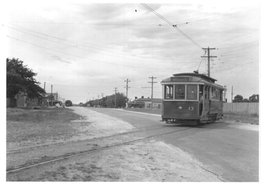 Ballarat Tramway Museum
Photograph - Ballarat tram 13 crossing Albert St, Ken Winney, 12/1949
The photograph shows SEC Ballarat tram No. 13 crossing Albert St on its way to Sebastopol. Has some of the Sebastopol shops in the background on the left side of the image. Photo by I K Winney of Sydney, 12/1949.Yields information about tram 13 and the location where the tram crossed Albert St. Sebastopol.Black and white photograph with photographers details on rear."Car No. 13 en route to Sebastopol crossing from left to right side of road, Ballarat 12/1949, I K Winney"tramcars, sebastopol, albert st., tram 13 -
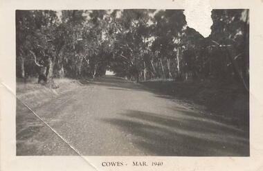 Phillip Island and District Historical Society Inc.
Photographs, 1940's
Seven photographs from a collection of 33 donated by Leonie Brennan. Photographs belonged to Edward (Ted) Sands, hairdresser.Photograph 215-10. Phillip Island Tourist Road (Cowes to Newhaven) in 1940, showing mature eucalypt trees on both sides of the road. Photograph 215-11. Car and tent possibly on a foreshore area on Phillip Island. The car was owned by "Roy". Photograph 215-12. Phillip Island Hotel in Walpole Street, Cowes. Photograph 215-13. Newhaven Boys Home showing farm buildings. Photograph 215-14. Bayview Guest House, The Esplanade, Cowes, with distinctive front fence. Photograph 215-15. The Chapel at Newhaven Boys Home, Phillip Island. Photograph 215-16. The Alvina ferry with passengers on board. Photograph 215-17. Very dark photograph of shops in Cowes. One with sign showing ice-creams and a Grocer Shop next door.Four photographs with "Cowes" month and 1940.main tourist road, phillip island, camp site phillip island, phillip island hotel cowes, hotels, guesthouses cowes phillip island, bayview guesthouse cowes, newhaven boys home phillip island, newhaven boys home chapel, the alvina, ferries, shops at cowes phillip island, mr edward (ted) sands, leonie brennan -
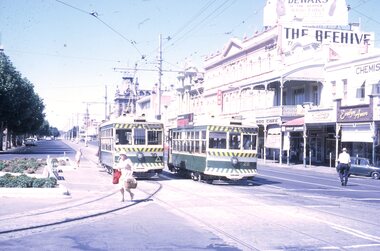 Ballarat Tramway Museum
Slide - 35mm slide/s - set of 4, Peter Moses, Jan. 1969
Set of four colour slides taken at Charing Cross Bendigo, Jan. 1969. .1 - Trams 30 and 28 travelling to North Bendigo and Golden Square respectively. Has the Beehive building in the background, along with W.M.I. Jones Chemist, Evelyn Amor shop, Dewars Whiskey rooftop advertisement. 28 has a SEC Briquettes roof advertisement. .2 - As above but with the front or bogie tram in the photo. Also has A. G. Treloar Optician's shop. Kodak cardboard mount slide, taken by Peter Moses, Jan. 1969. .3 - Close up photo of Birney No. 30, with 28 in the background. .4 - No. 28 leaving for Golden Square with the Plaza building, the Cenotaph, and the City Family Hotel in the background. Kodak cardboard mount slide, taken by Peter Moses, Jan. 1969.On the rear of all the slides "P. Moses" in black ink .1 - "Bendigo Charing Cross" and in red ink "19" .2 - "Bendigo three trams / Charing Cross" and in red ink "21" .3 - "Bendigo" and in red ink "23" .4 - "Bendigo Charing Cross" and in red ink "14". tramways, trams, bendigo, tram 28, tram 30 -
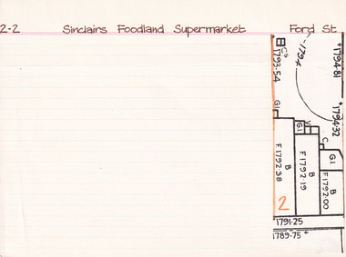 The Beechworth Burke Museum Research Collection
Card (Series) - Index Card, George Tibbits, Ford Street, Beechworth, 1976
George Tibbits, University of Melbourne. Faculty of Architecture, Building and Town & Regional PlanningIndex system that support the research for Beechworth : historical reconstruction / [by] George Tibbits ... [et al]Arranged by street names of BeechworthEach index card includes: street name and number of property, image of property, allotment and section number, property owners and dates of ownership, description of the property according to rate records, property floor plan with dimensions.beechworth, george tibbitsbeechworth, george tibbits -
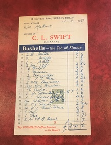
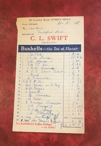 Surrey Hills Historical Society Collection
Document - Account, C. L. Swift order docket re Mrs Matthews. 21/8/1957, 21 August 1957
Clive Leslie Swift (RAAF 430415) was born in Elsternwick in 1924 and served in the RAAF in Borneo during WW2. He was mentioned in dispatches. He married Enid (Ina) Mary Smith in 1947. Together they ran the grocery store at 10 Croydon Road from 1949 until some time after 1954. In the 1980s they were living in Highbury Road, East Burwood and Clive was working for Unigate (later Bonlac) in a managerial position. (REF: Oral testimony, Libby Wilson, Canterbury History Group). The shop continued after the Swifts left but was later destroyed by fire. Clive Swift died in March 2014. This and other dockets were tucked into Ruth Matthews' recipe folder. Ruth and Harold Geoffrey (Geoff) Matthews lived at 42 Guildford Road, Surrey Hills. The donor recalled that her paternal grandmother (Ethel May Matthews) also occasionally shopped at the Swifts' shop as it was closer to her home (31 Guildford Road) than either than Griffith’s on Union Road or Thomas’ on Maling Road . Dockets such as these are reflective of shopping in the pre-supermarket era when women generally walked to the local shop or had proprietors or a staff member come to the house to take weekly orders. A pre-printed grocery docket for C. L. Swift (Late R.A.A.F.) on cream (discoloured) paper printed in black, red and blue filled in with 20 hand-written items, their prices and the total of the grocery order. Signed with initials as having been paid. Order was for Mrs Matthews of Guildford Road.On the rear in blue ink an addition in pounds, shillings and pence.clive leslie swift, miss enid (ina) mary smith, mrs enid (ina) mary swift, croydon road, guildford road, grocery store, docket, accounts, bushells tea, mrs ruth matthews, harold geoffrey matthews, 'geoff' matthews -
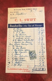 Surrey Hills Historical Society Collection
Document - Account, C. L. Swift order docket re Mrs Matthews. 21/8/1957, 3 July 1957
Clive Leslie Swift (RAAF 430415) was born in Elsternwick in 1924 and served in the RAAF in Borneo during WW2. He was mentioned in dispatches. He married Enid (Ina) Mary Smith in 1947. Together they ran the grocery store at 10 Croydon Road from 1949 until some time after 1954. In the 1980s they were living in Highbury Road, East Burwood and Clive was working for Unigate (later Bonlac) in a managerial position. (REF: Oral testimony, Libby Wilson, Canterbury History Group). The shop continued after the Swifts left but was later destroyed by fire. Clive Swift died in March 2014. This and other dockets were tucked into Ruth Matthews' recipe folder. Ruth and Harold Geoffrey (Geoff) Matthews lived at 42 Guildford Road, Surrey Hills. The donor recalled that her paternal grandmother (Ethel May Matthews) also occasionally shopped at the Swifts' shop as it was closer to her home (31 Guildford Road) than either than Griffith’s on Union Road or Thomas’ on Maling Road . Dockets such as these are reflective of shopping in the pre-supermarket era when women generally walked to the local shop or had proprietors or a staff member come to the house to take weekly orders. A pre-printed grocery docket for C. L. Swift (Late R.A.A.F.) on cream (slightly discoloured) paper printed in black, red and blue filled in with 19 hand-written items, their prices and the total of the grocery order. A green and cream duty stamp to the value of 3d is attached and over-signed with initials as having been paid. Order was for Mrs Matthews of Guildford Road.clive leslie swift, miss enid (ina) mary smith, mrs enid (ina) mary swift, croydon road, guildford road, grocery store, docket, accounts, bushells tea, mrs ruth matthews, harold geoffrey matthews, 'geoff' matthews -
 Surrey Hills Historical Society Collection
Document - Account, C. L. Swift order docket re Mrs Matthews. 21/8/1957, 13 August 1957
Clive Leslie Swift (RAAF 430415) was born in Elsternwick in 1924 and served in the RAAF in Borneo during WW2. He was mentioned in dispatches. He married Enid (Ina) Mary Smith in 1947. Together they ran the grocery store at 10 Croydon Road from 1949 until some time after 1954. In the 1980s they were living in Highbury Road, East Burwood and Clive was working for Unigate (later Bonlac) in a managerial position. (REF: Oral testimony, Libby Wilson, Canterbury History Group). The shop continued after the Swifts left but was later destroyed by fire. Clive Swift died in March 2014. This and other dockets were tucked into Ruth Matthews' recipe folder. Ruth and Harold Geoffrey (Geoff) Matthews lived at 42 Guildford Road, Surrey Hills. The donor recalled that her paternal grandmother (Ethel May Matthews) also occasionally shopped at the Swifts' shop as it was closer to her home (31 Guildford Road) than either than Griffith’s on Union Road or Thomas’ on Maling Road . Dockets such as these are reflective of shopping in the pre-supermarket era when women generally walked to the local shop or had proprietors or a staff member come to the house to take weekly orders. A pre-printed grocery docket for C. L. Swift (Late R.A.A.F.) on cream (slightly discoloured) paper printed in black, red and blue filled in with 19 hand-written items, their prices and the total of the grocery order. A green and cream duty stamp to the value of 3d is attached and over-signed with initials as having been paid. Order was for Mrs Matthews of Guildford Road.clive leslie swift, miss enid (ina) mary smith, mrs enid (ina) mary swift, croydon road, guildford road, grocery store, docket, accounts, bushells tea, mrs ruth matthews, harold geoffrey matthews, 'geoff' matthews -
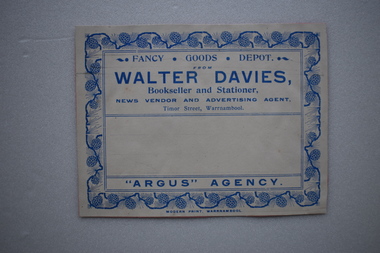 Warrnambool and District Historical Society Inc.
Label, Walter Davies
Walter Davies came to the Warrnambool area in the mid 1850's and established a newsagency, book shop and stationery business. After his death the business continued into the 20th century with family members and others using the same business name.This is a significant label as it was used by a prominent business in Timor Street, Warrnambool.Buff coloured label with blue text and decorative border .The label is adhered to a piece of pink card.FANCY . GOODS. DEPOT. WALTER DAVIES. Bookseller and Stationer. NEWS VENDOR AND ADVERTISING AGENT. Timor Street, Warrnambool "ARGUS" AGENCY MODERN PRINT, WARRNAMBOOLwalter davies, newsagency, book shop, stationers, warrnambool -
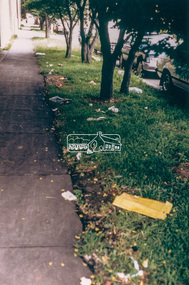 Eltham District Historical Society Inc
Photograph - Colour Print, Eltham Shire Council, Litter, Luck Street, Eltham, c.1988
One of a series of 6 images taken by Eltham Shire Council officers recording litter being prevalent around the shopping precinct and carparks spreading from Luck Street through Commercial Place top Arthur Street, Elthamarthur street, car park, carparks, commercial place, eltham shopping centre, eltham shops, litter, luck street -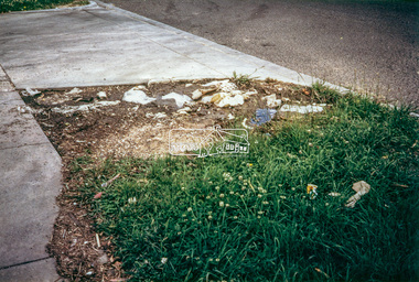
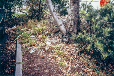
 Eltham District Historical Society Inc
Photograph - Colour Print, Eltham Shire Council, Litter, Luck Street carpark entrance, Eltham, c.1988
One of a series of 6 images taken by Eltham Shire Council officers recording litter being prevalent around the shopping precinct and carparks spreading from Luck Street through Commercial Place top Arthur Street, Elthamarthur street, car park, carparks, commercial place, eltham shopping centre, eltham shops, litter, luck street -
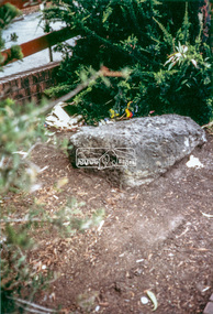 Eltham District Historical Society Inc
Photograph - Colour Print, Eltham Shire Council, Litter near entrance ramp to old Woolworths/Coles store in Eltham Village, c.1988
One of a series of 6 images taken by Eltham Shire Council officers recording litter being prevalent around the shopping precinct and carparks spreading from Luck Street through Commercial Place top Arthur Street, Elthamarthur street, car park, carparks, commercial place, eltham shopping centre, eltham shops, litter, luck street -
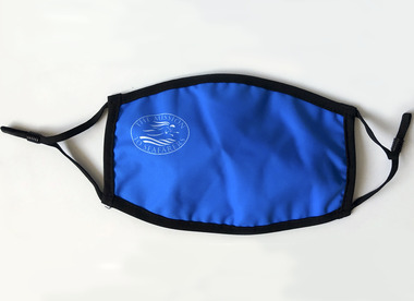 Mission to Seafarers Victoria
Functional object - Face mask, Mission to Seafarers Victoria, 2020
During the Covid 19 pandemic, the Mission to Seafarers was forced to close and stopped its activities on site. However the staff continued the ship visiting, shopping and delivering their goods to the seafarers. The wearing of the face mask was enforced during the second lockdown.The face mask is the symbol of the 2020 pandemic. Melbourne had one of the longest lockdowns in the world and the wearing of face masks became a symbol of the pandemic.Blue fabric face mask with black elasticLogo of the Mission to Seafarers with the Flying Angelcovid 19, pandemic, lockdown, face mask, marketing, 2020, mission to seafarers, mtsv shop -
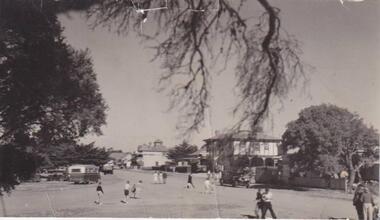 Phillip Island and District Historical Society Inc.
Photograph, San Remo
Broad view of The Esplanade beneath an overhanging branch of tree, looking at hotels and shops. On the right is a large bush to the left a large tree. A bus, car and truck are parked to left and unidentifiable figures of people walking to and fro across the road.Esplanade, San Remolocal history, photographs, san remo, black & white photograph, mona condrick -
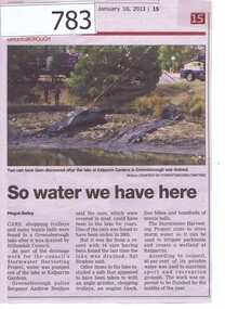 Greensborough Historical Society
Newspaper clipping, Diamond Valley Leader, So water we have here, 16/01/2013
This article is about the recovery of stolen vehicles from the Kalparrin Lake after it was drained as a part of the Stormwater harvesting project. Other items recovered included a safe, shopping trolleys, an engine block, five bicycles and hundreds of tennis balls.The Stormwater will be used to water parklands and create a wetland at Kalparrin.A small newspaper article featuring a colour photograph.kalparrin reserve, stormwater harvesting, stolen cars -
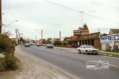
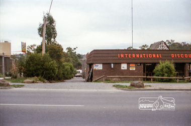
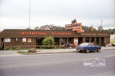
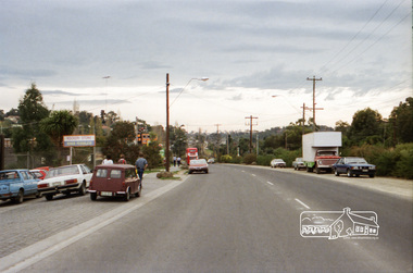
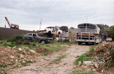
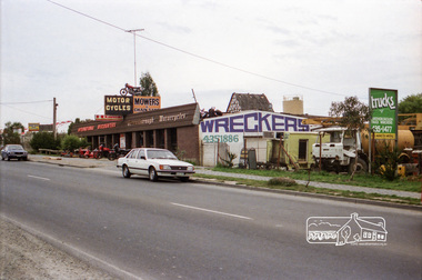 Eltham District Historical Society Inc
Photograph, Industrial development, Para Road, Briar Hill, c.1984, 1996
Views of industrial sites and shop fronts on Para Road, Briar Hill including the business 'Greensborough Motorcycles'. Para Road, Briar Hill is parallel to the Hurstbridge Railway Line. The building 'Greensborough Motorcycles' was destroyed by fire in the early 2000s.Roll of 35mm colour negative film, 4 stripsKodak CP 100 5094briar hill, greensborough, greensborough motorcycles, hutchinson's, industry, international discounters, para road -
 Eltham District Historical Society Inc
Photograph, Industrial development, Para Road, Briar Hill, c.1984, 1996
Views of industrial sites and shop fronts on Para Road, Briar Hill including the business 'Greensborough Motorcycles'. Para Road, Briar Hill is parallel to the Hurstbridge Railway Line. The building 'Greensborough Motorcycles' was destroyed by fire in the early 2000s.Roll of 35mm colour negative film, 4 stripsKodak CP 100 5094briar hill, greensborough, greensborough motorcycles, hutchinson's, industry, international discounters, para road