Showing 9725 items
matching west
-
 Bendigo Historical Society Inc.
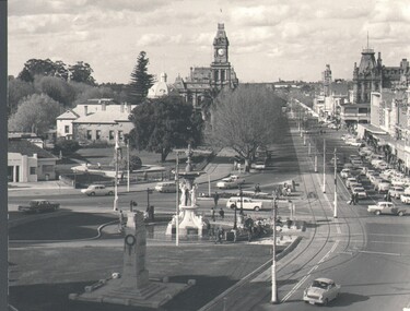
Photograph - WES HARRY COLLECTION: PALL MALL, 1972
Black and white photograph taken from the City Family Hotel tower looking north west along Pall Mall. Bottom centre is the fountain and the cenotaph, top centre is the post office clock tower.Martin Washingtonplace, bendigo, pall mall, pall mall, fountain, cenotaph, post office, tram tracks, shamrock hotel -
 Bendigo Historical Society Inc.
Map - SUBDIVISION OF STERNBERG'S ESTATE, 24/06/1920
Map: Subdivision of Sternberg's Estate, Crown Allotments 75, 76, 76A, 76B and 77, Parish of Rochester West, County of Bendigo. Parish plan Canvas backed ( number 133 in Map Cupboard 1)map, bendigo, rural, sternberg's, crown allotments 75, 76, 76a, 76b, 77, rochester west, county of bendigo -
 National Trust of Australia (Victoria)
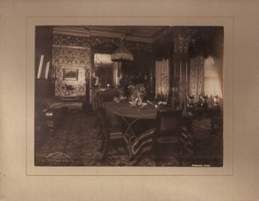
Photograph, Dining room, c1903
Black and white photograph mounted on light grey coloured card. Photograph shows Sargood's Dining Room taken from the north-west corner. Photograph incorrectly identified as the Drawing Room by the photographic studio. Written on photograph: 'DRAWING ROOM' Stamped onto front left bottom corner of photograph: 'Johnstone & O'Shannessy/ & Co./ Propy. Ltd/ Collins St. Melb.' Written on verso of mount: 'Copy of this photograph. Rippon Lea pamphlet' sargood family, rippon lea -
 Whitehorse Historical Society Inc.
Photograph, Narmara Primary School, 13/01/1994 12:00:00 AM
Coloured photo of Narmara Primary School site looking West along Highbury Road. School on North side of Highbury Road between Middleborough and Blackburn Roads. Since demolished and site developed for housing.narmara primary school, warner, philip -
 Rutherglen Historical Society
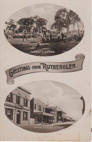
Image, Greetings from Rutherglen, 1910 to 1912
Black and white postcard with two oval photographs with "Greetings from Rutherglen" on a banner between them. The top photograph is of workmen cutting down trees. The bottom one is a view of Main Street looking west.At bottom of top photograph: "Forest Clearing." At bottom of bottom photograph: "Main Street."land clearing, timber felling, main street, bank of australasia, s younkman & co, victoria hotel -
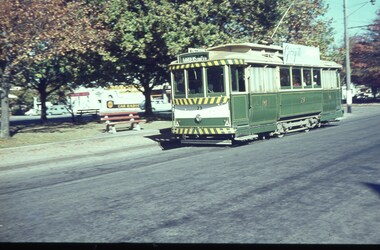
 Ballarat Tramway Museum
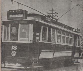
Drawing - Illustration/s, Geelong 18
Illustration or printed photograph from a newspaper or magazine adhered to a sheet of cardboard of Geelong 18, converted for one man operation with the destination of West. Tram in green and cream colour scheme - late 1930's? trams, tramways, geelong -
 Ballarat Tramway Museum
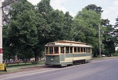
Slide - 35mm slide/s, Travis Jeffrey, Dec. 1992
Plastic mount (black base, white cover) of No. 27, Wendouree Parade, December 1992. Photo by Travis Jeffrey. Gavin Young driving. Tram has destination of Gardens via Sturt St. West.tramways, trams, wendouree parade, btm, tram 27 -
 Ballarat Tramway Museum
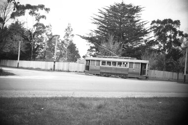
Negative, Wal Jack, late 1940's or early 1950's
Yields information about the intersection of Hamilton Ave and Sturt St west.Negative and Digital image of the Wal Jack Ballarat Negative file of No. 21 turning from Hamilton Ave into Sturt St West with the Loreto Convent fence behind. The Convent tram stop is behind the tram.trams, tramways, hamilton ave, sturt st west, tram 21 -
 Ballarat Tramway Museum
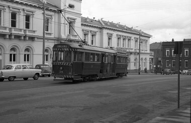
Negative, Wal Jack, early 1960's
Yields information about tram using the cross over in Lydiard St North.Negative and Digital images of the Wal Jack Ballarat Negative file of No. 39 using the Lydiard St North crossover. The tram has the destination of Sturt St West. In the background is the Post Office and the Commonwealth Bank. trams, tramways, lydiard st north, crossover, tram 39 -
 Ballarat Tramway Museum
Slide - 35mm slide/s, c1963
Tram 28 in Sturt St, with Gardens via Sturt St. West destination, trees are going into autumn colours. Tram has the final colour scheme of lights and deep white strip on front dash.'B' in blue inktramways, trams, sturt st., tram 28 -
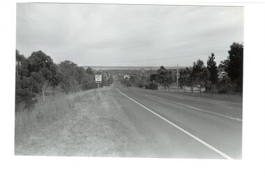 Buninyong & District Historical Society
Photograph - B/W photograph, Mr. Clive J. Brooks, Eastern approach to Buninyong Midland Highway 1994, April 1994
Approach to township of Buninyong prior to amalgamation with Ballarat City Council. Buninyong shire town sign visible in foreground.Record of Buninyong Shire prior to amalgamationBlack and white photograph of the Eastern approach to Buninyong from the Midland Highway taken from opposite Ballantrae looking West. In left foreground is an example of Buninyong shire town sign before amalgamation 1994.buninyong shire, midland highway, street scene -
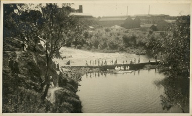 Kew Historical Society Inc
Photograph - Crossing Dights' Falls on the Yarra by foot
Dight’s Falls in Studley Park is an artificial weir built on a natural rock bar across the Yarra. The weir was built in the 1840s to provide water to the ‘Ceres’ flour-mill, one of the first in Victoria. The falls were later to become known as Dight’s Falls after the owners of the mill. Later, a pumping station was built on the Kew side of the river, which pumped water uphill to a reservoir in Walmer Street that provided water to the Melbourne Botanical Gardens and to Albert Park Lake. The area around Dight’s Falls was and is frequently used for recreational activities.Rare original print photograph of people walking across Dight's Falls when the river flow was low. View west towards Abbotsford. Photograph taken from Kew side of river above the Falls.Reverse: "M Holmes"dight's falls, river yarra -- kew - abbotsford -
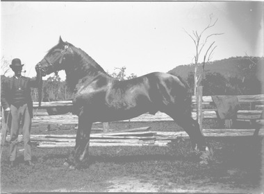 Wodonga & District Historical Society Inc
Negative - Haeusler Glass Negatives Collection - Ted McKoy and his horse
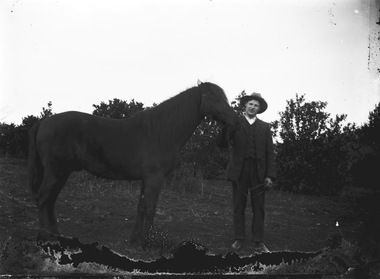
The Wodonga Historical Society Haeusler Collection provides invaluable insight into life in late nineteenth and early twentieth century north east Victoria. The collection comprises manuscripts, personal artefacts used by the Haeusler family on their farm in Wodonga, and a set of glass negatives which offer a unique visual snapshot of the domestic and social lives of the Haeusler family and local Wodonga community. Edgar Francis ‘Ted’ McKoy. Born on 21 January 1881 at Wodonga to parents Alexander Joseph McKoy and Emma House. He was the 11th child born to Joseph and Emma. During 1858, Joseph and Emma travelled from Parks Camp in New South Wales to Wodonga. Joseph’s brother James was already living on the border. They settled at Wodonga and raised a very large family. Ted grew up on the horse stud of his parents – the land is where the Wodonga Caravan Park and Wodonga TAFE are now located. Several streets in the area are named after Joseph’s horses. Ted developed his considerable skills with horses with the help of his father who was a renowned breeder. Ted married Laura Annie McVean at 'The Vicarage' Wodonga on 1 Mar 1905. They had four children - Harold Glenn, Vera, Beatrice Mabel and Gladys. They settled at Ted’s stud Moorefield Park. Ted was a well-known horse breeder in his own right and won many prizes at agricultural shows. He had trotting horses, show hacks and Clydesdales. He worked for many years as the Wodonga Pound Keeper and was well-known throughout the district. Ted died on 7 Jul 1947 at Albury District Hospital and was buried at the Wodonga Cemetery.This item is unique and has well documented provenance and a known owner. It forms part of a significant and representative historical collection which reflects the local history of Wodonga. It contributes to our understanding of domestic and family life in early twentieth century Wodonga, as well as providing interpretative capacity for themes including local history and social history.Digital image created from the Haeusler Glass negative collection. Mr. Ted McKoy showing one of his horses. The McKoy family ran a horse stud for many years in Wodonga West, Victoria.wodonga pioneers, haeusler family, glass negatives, dry plate photography, mckoy family wodonga -
 Wodonga & District Historical Society Inc
Negative - Haeusler Glass Negatives Collection - Ted McKoy and his horse
The Wodonga Historical Society Haeusler Collection provides invaluable insight into life in late nineteenth and early twentieth century north east Victoria. The collection comprises manuscripts, personal artefacts used by the Haeusler family on their farm in Wodonga, and a set of glass negatives which offer a unique visual snapshot of the domestic and social lives of the Haeusler family and local Wodonga community. Edgar Francis ‘Ted’ McKoy. Born on 21 January 1881 at Wodonga to parents Alexander Joseph McKoy and Emma House. He was the 11th child born to Joseph and Emma. During 1858, Joseph and Emma travelled from Parks Camp in New South Wales to Wodonga. Joseph’s brother James was already living on the border. They settled at Wodonga and raised a very large family. Ted grew up on the horse stud of his parents – the land is where the Wodonga Caravan Park and Wodonga TAFE are now located. Several streets in the area are named after Joseph’s horses. Ted developed his considerable skills with horses with the help of his father who was a renowned breeder. Ted married Laura Annie McVean at 'The Vicarage' Wodonga on 1 Mar 1905. They had four children - Harold Glenn, Vera, Beatrice Mabel and Gladys. They settled at Ted’s stud Moorefield Park. Ted was a well-known horse breeder in his own right and won many prizes at agricultural shows. He had trotting horses, show hacks and Clydesdales. He worked for many years as the Wodonga Pound Keeper and was well-known throughout the district. Ted died on 7 Jul 1947 at Albury District Hospital and was buried at the Wodonga Cemetery.This item is unique and has well documented provenance and a known owner. It forms part of a significant and representative historical collection which reflects the local history of Wodonga. It contributes to our understanding of domestic and family life in early twentieth century Wodonga, as well as providing interpretative capacity for themes including local history and social history.Digital image created from the Haeusler Glass negative collection. Mr. Ted McKoy showing one of his horses. The McKoy family ran a horse stud for many years in Wodonga West, Victoria.wodonga pioneers, haeusler family, glass negatives, dry plate photography, mckoy family wodonga -
Port Melbourne Historical & Preservation Society
Audio - PMHPS Meeting, David Sornig, Dudley Flats, Garry Smart, 29 Apr 2019
David Sornig talks about his book"Blue Lake: Finding Dudley Flats and the West Melbourne Swamp" Duration1:15:08 (including meeting preliminaries) PMHPS Meeting 29/4/2019natural environment, dudley flat -
 Stawell Historical Society Inc
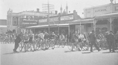
Photograph, Stawell Amateur Cycle Club in Main Street c1940
B/W photograph of Cyclist Group in Main Street Stawell Shows Town Hall in Background and various shops in background M Maloney Motor & Cycle Depot, H.V.A. Callander Baker, A West, Butchersport, cycling, streetscape -
 Lakes Entrance Historical Society
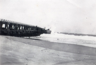
Photograph - Western Pier, 1910c
Black and white photograph showing wooden western pier with new concrete extension on seaward end and crane. Two men on top of pier, ocean breaking on beach west of pier, at Lakes Entrance, Victoria.waterways, machinery, piers -
 Lakes Entrance Historical Society
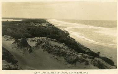
Postcard - Sand Hummocks, Bulmer H D, 1940
Black and white postcard taken from the hummocks to the west. View is looking to the east showing ocean and beach, wind swept scrub covered dunes, and distant view of Gippsland Lakes. Lakes Entrance Victoriawaterfront, ocean, topography -
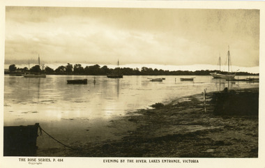 Lakes Entrance Historical Society
Postcard - Boat Harbour, The Rose Series, 1900c
Black and white postcard of the front lake, showing seven vessels moored in the lake at dusk, small jetty, shore stewn with seagrass. In the background, southern shore of the lake west of the entrance. Lakes Entrance VictoriaEvening by the River, Lakes Entrance Victoriajetties, boats and boating, waterfront -
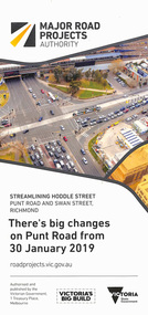 Melbourne Tram Museum
Pamphlet, Major Road Projects Authority, "There's big changes on Punt Road from 30 January 2019", Jan. 2019
Pamphlet describing roadworks at Punt Road and Swan St intersection during January and February 2019. Photo of intersection has a B class at the Punt Road tram stop travelling west towards the city.trams, tramways, road works, punt rd, swan st -
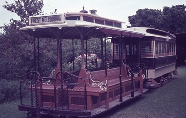 Melbourne Tram Museum
Slide, Keith Caldwell, 17/03/1963 12:00:00 AM
Agfa Colour slide, cardboard, by Keith Caldwell dated 17-3-1963 of Les Twentyman's cable trams set rolled out for photographs in Northcote. Grip car has the destination of West Melbourne.In ink "Cable Grip car and trailer 17-3-1963.trams, tramways, cable trams, northcote, preserved trams -
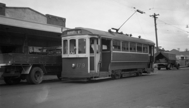 Melbourne Tram Museum
Negative, Wal Jack, 17/12/1954 12:00:00 AM
Black and white negative, by Wal Jack, of T 179 at the Russell St West Footscray terminus in Barkly St. The building facade in the background remains at entry date. Tram has the destination of Russell St.trams, tramways, footscray, t class, barkly st, russell st, tram 179 -
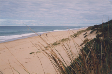 Lakes Entrance Historical Society
Photograph - Ocean Beach, Lakes Post Newspaper, 1/06/2000 12:00:00 AM
Colour photograph taken from Eastern Beach looking towards the west showing expanse of sand between calm ocean and shrub covered coastal dunes, two people on sand Lakes Entrance Victoriacoast, ocean, waterways -
 Ballarat Tramway Museum
Postcard, "Sturt St Ballarat", 1905
Printed colour postcard of an ESCo tram west bound at the intersection of Sturt and Lydiard St. Ballarat, c1905. Has a number of horse drawn vehicles and pedestrians in the picture. Taken from the Post Office tower looking south west, with buildings on the south side of Sturt St., west of Lydiard St in the view. Has the Robert Burns statue in the bottom left hand corner. Titled "Sturt Street, Ballarat" along the bottom edge. On rear of postcard are the words "Post Card", and guidance where the message may be written and space for the address. In the stamp section, details for Inland 1/2d stamp needed, and for Foreign 1d. On the bottom of the space for the stamp, has the words "Printed in Britain" See Reg Item 3151 for the same photo (slightly different position and different cloud effects), but different manufacturer. trams, tramways, esco, sturt st, postcards, lydiard st. -
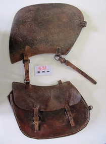 Uniting Church Archives - Synod of Victoria
Saddlebag
This small saddle bag was carried on the off-side (right hand side) of the saddle. Nyah West is a town in Victoria, near the Murray River. It is near the Murray Valley Highway, 371 kilometres north-west of Melbourne and 27 kilometres north-west of Swan Hill.Dark brown leather single small saddlebag. The bag is secured with two buckles. -
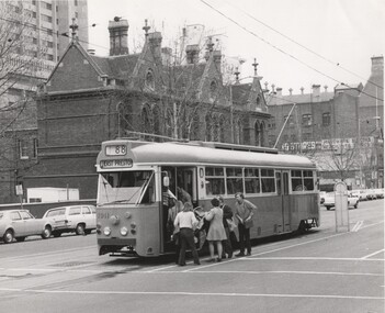 Melbourne Tram Museum
Photograph - Black and White - PCC 1041 - Bourke St 1973
Photograph of PCC car 1041 (Route 88, West Preston) built by the MMTB in 1973 as a prototype for the Z class tram at the King St tram stop, loading passengers through the front door. In the background is Melbourne West or Bourke St West Police Station. Yields information about the location, the streetscape and the prototype tram in use at the time. Black and white photograph of PCC 1041 - Bourke St at Kings St 1973 on rear in ink "RSCP330" and "1973"tramways, trams, tram 1041, mmtb, bourke st, route 88, east preston, bourke street west police station, pcc class -
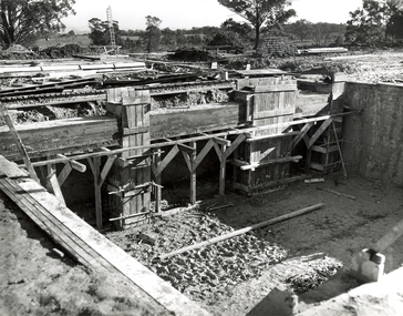 Federation University Historical Collection
Photograph, N.l. Harvey & Son, Mount Helen Campus, 1968, 1969
The Federation University campus at Mount Helen was first used by students in 1970.Seven photographs of the Mt Helen Campus Stage one development. .1) Aerial view of foundation work, from west, towards Green Hill .2) Aerial View from South. Earthworks and foundations .3) Aerial View from south west. Earthworks, general view .4) Aerial View from above the South West corner of E building. .5) Aerial View from North East. Gear Avenue in background .6) Aerial View from North West. Earthworks extend from Gear Avenue .7) Ground level view. First columns of E building. .13) Mt Helen development Stage One, Engineering Diploma Buildings. This image shows the wall beam and pier construction to the East Wall of the Fluid Mechanics Laboratory adjacent to the pump chamber, 17 June 1968. .18) Flume Pit and Pump Chamber, 15 July 1968. .28) East Wing Pit Looking North, 26 August 1968 .40) Construction as of 04 November 1968federation university, federation university australia, feduni, university of ballarat, ballarat college of advanced education, ballarat institute of advanced education, building, earthworks, foundation, early development, soil testing laboratory -
 Bacchus Marsh & District Historical Society
Map, Gorrockburkchap Parish Map, County of Grant c.1906
The parish of Gorrockburkchap (sometimes spelled Gorrockburkghap) lies to the west and south west of the township of Bacchus Marsh. The locality of Rowsley is situated within this parish area.A single page paper map showing the parish plan for Gorrockburkchap in the County of Grant. A cadastral map showing parish boundaries and land ownership The map is pasted into a bound volume containing 76 maps or plans in total. High resolution digital image stored on BMDHS computer network. gorrockburkchap parish maps, rowsley victoria maps, bacchus marsh region parish plans -
 Bacchus Marsh & District Historical Society
Map, Gorrockburkchap Parish Map, County of Grant c.1915
The parish of Gorrockburkchap (sometimes spelled Gorrockburkghap) lies to the west and south west of the township of Bacchus Marsh. The locality of Rowsley is situated within this parish area.A single page paper map showing the parish plan for Gorrockburkchap in the County of Grant. The map is pasted into a bound volume containing 76 maps or plans in total. High resolution digital image stored on BMDHS computer network. gorrockburkchap parish maps, rowsley victoria maps -
 Bacchus Marsh & District Historical Society
Map, Gorrockburkchap Parish Map, County of Grant
The parish of Gorrockburkchap (sometimes spelled Gorrockburkghap) lies to the west and south west of the township of Bacchus Marsh. The locality of Rowsley is situated within this parish area.A single page paper map showing the parish plan for Gorrockburkchap in the County of Grant. The map is pasted into a bound volume containing 76 maps or plans in total. High resolution digital image stored on BMDHS computer network. gorrockburkchap parish maps, rowsley victoria maps