Showing 27535 items
matching yarra-river
-
 Slovenian Association Melbourne
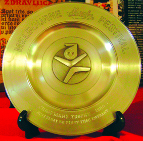
Gold plated metal trophy, Melbourne Moomba Festival trophy 1980, 1980
Important Victorian Labour Day annual event in Melbourne and many floats form a lengthy parade - celebration in the streets of Melbourne, concluding at the Alexandra Gardens along River Yarra; it is a presentation of various communities, arts and cultural performances in the State of Victoria.Getting together, celebrating multicultural community and many facets of social lifeGold plated trophy presented to Slovenian Association Melbourne in 1980 for the entry of a float at the Moomba parade.Melbourne Moomba Festival Chairmans Trophy 1980 Best Float by First Time Entrantslovenian association melbourne, moomba parade, moomba festival melbourne, moomba float -
 Kew Historical Society Inc
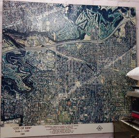
Photograph - Aerial Photograph, Division of Survey and Mapping, Department of Property and Services, City of Kew, Scale 1 : 3,000, 1989, 1989
The City of Kew was a local government area about 4 kilometres east of Melbourne, the state capital of Victoria, Australia, on the southeast bank of the Yarra River. The city covered an area of 14.56 square kilometres, and existed from 1860 until 1994.Very large aerial photograph of “City of Kew” Scale 1 : 3,000. 1989. “City of Kew” Scale 1 : 3,000. 1989. Photomosaic compiled by Division of Survey and Mapping, Department of Property and Services. © Crown (State of Victoria) Copyright 1990.city of kew, kew (vic.), aerial photography -
 Port of Echuca
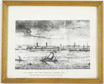
Work on paper - Framed print of a Lithograph
Small wooden frame of a Lithograph showing a river scene with 2 paddle steamers, a sailing boat and an Indigenous bark canoe on a river, with a town and a wharf in the background. The sky is cloudy. LADY AUGUSTA & MARY ANN at Swan Hill, September 1853. (By courtesy of South Australian Archives) -
 Lakes Entrance Regional Historical Society (operating as Lakes Entrance History Centre & Museum)
Book, North East Regional Tourist Authority, North East Victoria, 1980
A brief record of the region from the Murray River in the north to the Dargo High Plains in the south, from Yarrawonga and Wangaratta in the west to the Indi River in the east. Illustrated with coloured photographs.tourism, mines and mining, settlers, water supply -
Lakes Entrance Regional Historical Society (operating as Lakes Entrance History Centre & Museum)
Photograph, 1910 c
Sepia photograph showing steamer JCD on Mitchell River,high river bank behind steamer, post and rail fence on bank, few people on board. Bairnsdale, Victoria.S S J C D (Trading between Bairnsdale and Cunninghame)boats and boating, waterways, buildings -
 Sunbury Family History and Heritage Society Inc.
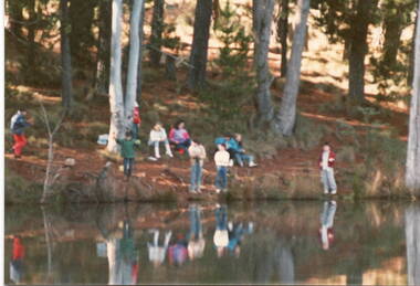
Photograph, School Camp, 1988
The children from Mickleham and Bulla Primary Schools were attending a school camp near Beechworth and were visiting a trout farm.A non- digital coloured photograph of a group of children by a river. Three people are standing very close to the edge, while the rest of the children are sitting further up on the river bank.school camps, beechworth -
 Phillip Island and District Historical Society Inc.
Financial record, Credit account from J.Kennon & Sons for N. L. Smith, Rhyll, 23 March 1914
J.Kennon & Sons were known particularly for their use of the chrome tanning process. They were also buyers and exporters of Australian skins and wool.The firm had tanning works,, established in 1863, offices and stores in the vicinity of River Street, Richmond and a leather warehouse in Bridge Road. [ Source -Heritage Victoria https://www.google.com/url?sa=t&rct=j&q=&esrc=s&source=web&cd=&cad=rja&uact=8&ved=2ahUKEwiI7OnmofT_AhUia2wGHXNGCaUQFnoECBQQAQ&url=http%3A%2F%2Fimages.heritage.vic.gov.au%2Fattachment%2F24257&usg=AOvVaw0ER8QGZ-3eW4PAg0VM909h&opi=89978449]HistoricalCream coloured account with details eg product and amount in black ink. Includes a separate piece of paper attached to page, with a recipe for vermin destroyer typed in red ink.Credit account of N. L. Smith, Rhyll, Phillip Island. One bag of Rabbit Weevily. March 23, 1914 J. Kennon & Sons River Street, Richmondn.l.smith rhyll, j.kennon and sons, rabbit poison, account, vermin -
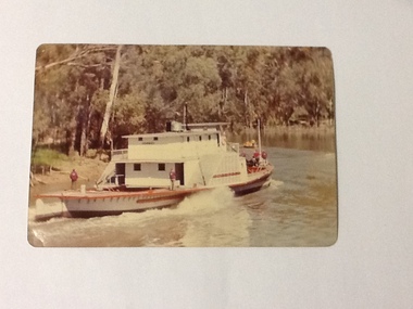 Port of Echuca
Colour Photograph, 1978
P. S. PEVENSEY: Dimensions: 111ft 5 ins X 23 ft X 6ft 8 ins. Tonnage:130 tons Built: 1910 at Moama, N. S. W. References : Book: Murray river Paddle Steamers by D. Wardle Permewan , Wright & Co. : pp. 72, 129, 157 The P. S. PEVENSEY holds historical and social significance for the Port of Echuca, being the cornerstone of their paddlesteamer fleet. The PEVENSEY was renamed for the TV series All the Rivers Run, to P. S. Philadelphia , playing a staring role in the program, which has resulted in the PEVENSEY becoming a tourist attraction and has increased tourism to the Port of Echuca. The PEVENSEY was originally designed for use on the Murrumbidgee river, named after Pevensey station on that river. It was then owned by Permewan Wright & co operating out of Echuca for many years. She returned to Echuca in 1975 to begin another life as part of the Port of Echuca tourism operation.Colour photograph of the P. S. Pevensey, taken from the water, looking at the rear of the boat. There are people (all in red jackets with a logo on the back-Port of Echuca workers?), some on the bow and 2 on the stern of the boat as it steams along the river. In front of the PEVENSEY is a small row boat with a group of people in it.On the front:PEVENSEY on the back of the boat. Printed on reverse: This paper manufactured by Kodak: Print made by Kodak: KODAK: OCT.78-Mriverboats, p.s.pevensey, echuca, port of, paddle steamers, echuca wharf -
 Kew Historical Society Inc
Photograph - Flooding of the Yarra Valley at Kew East, 1974
Flooding of the Yarra Valley, including that section of the Yarra bordering Kew and Kew East in the north and west of the municipality, was a regular occurrence. Extreme flood events of the Yarra River are recorded to have occurred in 1891, 1901, 1916, 1923 and 1934. The Municipality of Kew's response to these floods was to enact planning decisions restricting residential development in flood prone areas following the floods of 1916, 1921 and 1934. While floods continued after the development of the Upper Yarra Reservoir (construction 1948-57), the regularity and extent of these inundations diminished. During the nineteenth century, the land abutting the south side of the Yarra in Kew was devoted to dairy farming. In the twentieth century, before and after the construction of the Eastern Freeway, much of this low-lying area was used as golf courses and public parks.Late example of the capacity of the Yarra Valley at Kew to flood, even though drainage works and the Upper Yarra Reservoir had reduced their regularity.Original black and white print photograph of the low-lying land at East Kew under floodwater on 16 May 1974. The vantage point of the photographer is at Willsmere Road. The road itself is underwater.Annotation verso: "Willsmere Rd / Same as No.7 / 16 May 1974 11.15am"floods, yarra river, willsmere road -
 Kew Historical Society Inc
Photograph - Flooding of the Yarra Valley at Kew East, 1974
Flooding of the Yarra Valley, including that section of the Yarra bordering Kew and Kew East in the north and west of the municipality, was a regular occurrence. Extreme flood events of the Yarra River are recorded to have occurred in 1891, 1901, 1916, 1923 and 1934. The Municipality of Kew's response to these floods was to enact planning decisions restricting residential development in flood prone areas following the floods of 1916, 1921 and 1934. While floods continued after the development of the Upper Yarra Reservoir (construction 1948-57), the regularity and extent of these inundations diminished. During the nineteenth century, the land abutting the south side of the Yarra in Kew was devoted to dairy farming. In the twentieth century, before and after the construction of the Eastern Freeway, much of this low-lying area was used as golf courses and public parks.Late example of the capacity of the Yarra Valley at Kew to flood, even though drainage works and the Upper Yarra Reservoir had reduced their regularity.Original black and white print photograph of the low-lying land at East Kew under floodwater on 16 May 1974. The photograph is of Hyde Park looking north-east.Annotation verso: "Hyde Park looking nth-east / Flood Level / 16 May 1974 11.15am / R.L. 46.61"floods, yarra river, hyde park -
 Kew Historical Society Inc
Photograph - Flooding of the Yarra Valley at Kew, 1974
Flooding of the Yarra Valley, including that section of the Yarra bordering Kew and Kew East in the north and west of the municipality, was a regular occurrence. Extreme flood events of the Yarra River are recorded to have occurred in 1891, 1901, 1916, 1923 and 1934. The Municipality of Kew's response to these floods was to enact planning decisions restricting residential development in flood prone areas following the floods of 1916, 1921 and 1934. While floods continued after the development of the Upper Yarra Reservoir (construction 1948-57), the regularity and extent of these inundations diminished. During the nineteenth century, the land abutting the south side of the Yarra in Kew was devoted to dairy farming. In the twentieth century, before and after the construction of the Eastern Freeway, much of this low-lying area was used as golf courses and public parks.Late example of the capacity of the Yarra Valley at Kew to flood, even though drainage works and the Upper Yarra Reservoir had reduced their regularity.Original black and white print photograph of the low-lying land at East Kew under floodwater on 16 May 1974. The photograph is taken from 43 Kellett Grove.Annotation verso: "Kellett Gve No.43 / Flood Level / 16 May 1974 11.40am"floods, yarra river, kellett grove -
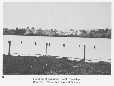 Eltham District Historical Society Inc
Work on paper (Sub-Item) - Photograph, Flooding at Diamond Creek Township
Black and white photograph of the Diamond Creek in flood at Diamond Creek township in 1934. In 1934 extensive flooding of the Yarra River and Diamond Creek set new records for flood plain level (Eltham Chronology EDHS) Nillumbik Historical Society collectionflood, diamond creek, flooding, nillumbik historical society -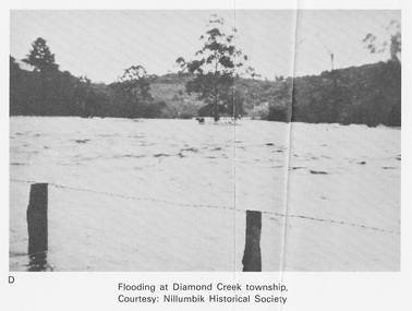
City of Kingston
Photograph - Colour, c. 1993
Patterson Lakes is a suburb in the City of Kingston that is built one kilometre upstream of the mouth of the Patterson River. The area is bordered by the Patterson River and Eel Race Drain which enters the Kananook Creek. The suburb consists predominantly of newer housing developments and the tidal canal system of the development joins Port Phillip Bay.Patterson Lakes and the Kananook Creek were previously part of the extensive Carrum Carrum Swamp. The area was once a source of fish and eels for the Mayone-Bulluk clan of the Bunurong people. Over time the area was drained and in 1973 investigations commenced into the development of a unique residential area that would be built adjacent to canals and waterways. It was originally proposed to be known as "Gladesville". The development would give the suburb's homeowners access to Port Phillip Bay "from their back door". Circa 1974, the area was rezoned from rural to residential and named Patterson Lakes. Development has been continuous since the 1970s with construction of residential housing, schools, shopping centres, marinas, a hotel and library.Laminated colour aerial photograph of the Carrum and Patterson Lakes region within City of Kingston. This 1993 image includes Patterson River Secondary College, Roy Dore Reserve, Kananook Creek and Nepean Highway. The railway line can be seen as it veers inland from Eel Race Road, Seaford. The section of Palm Beach Drive, Curlew Point Drive, Snapper Point Drive, Clipper Island and Myola Street in Patterson Lakes appears to be a recent development with many spare blocks and new houses under construction.patterson lakes, seaford, kananook creek, carrum carrum swamp, canals and waterways -
Port Melbourne Historical & Preservation Society
Photograph - Aerial view of J Kitchen and Sons site, Ingles Street, Port Melbourne, early 1930s, 1930s
Large Black and White aerial photograph on brown cardboard showing Kitchen and Sons buildings including the 1925 Administrative Building No 34 on Ingles st.Photograph taken looking North Easterly with Swanston and Barret Pty concrete works; Port Melbourne Football ground in foreground; Yarra River in top left hand corner; showing South Melbourne and Royal Botanic Gardens in the distance. Taken in the early 1930sindustry - manufacturing, built environment - industrial, j kitchen & sons pty ltd -
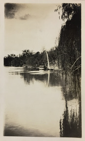 Kew Historical Society Inc
Photograph - Yarra River, Studley Park, 1924
Henry Beater Christian (1886-1962) , was a descendant of one of the earliest settler families in Kew. Employed at the Kew Asylum as a 'public servant', he was a skilled amateur photographer, photographing numerous scenes in Kew and on his travels around Victoria. The majority of his photographs date from 1916 to 1929. His finest photographs are housed in two photograph albums. Digital copy of a photograph from page 7 of the 47-page photograph album containing 261 gelatinous silver images, loaned by Diane Washfold with permission given to digitise and hold a copy in our collection. This photograph shows a covered tourist ferry moored on the river bank at Studley Park. Tourist cruises traversed the Yarra between Princess Bridge and Heidelberg, stopping at scenic points along the journey. "Studley Park / Kew"henry beater christian (1886-1962), landscape photography, kew (vic.) — yarra river, christian-washfold collection, photograph albums, kew, ferries, tourism, studley park -
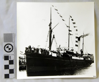 Flagstaff Hill Maritime Museum and Village
Photograph
Black and White Photograph of S.S Casino arriving in Port. Taken 1930-1932. People on the deck and on the river banks waving. Smoke coming from funnel. The S.S. Casino was a passenger and freight steamer built in Dundee, Scotland, in 1882 for the Newcastle and Hunter River Steam Navigation Company of N.S.W. She weighed 425 tons gross with a length of 160.4 feet, beam of 24.1 feet and depth of 10.2 feet. She had saloon accommodation for 35 people, forecabin for 25 more people, and she carried 300 tons of cargo. While on her delivery journey on May 30th 1882 the S.S. Casino called in at the Port of Warrnambool for coal ., narrowly escaping going ashore in gale force winds due to the quick action of the pilot. At that time, still at anchor, she impressed the directors of the Belfast and Koroit Steam Navigation Company so much that they bought her immediately; she was ideal for trade in along the West Coast of Victoria. (Belfast is the original name for Port Fairy, South West Victoria. The Belfast and Koroit Steam Navigation Company was first managed by Messers. Saltau and Osburne and after the passing of Mr. Osburne, by produce merchants Messers H. Sautau and Sons, whose had a hay and corn store and shipping agency was on the corner of Liebig and Koroit Streets in Warrnambool. ) The S.S. Casino became “the most famous steamer to operate in Victorian waters along the West Coast” by author Jack Loney. Captain Boyd was her first Master, followed by Captain Chapman, who stayed with her 1890 until 1924. Captain W. Robertson followed for a short term, then Captain Middleton then took command 1925 - 1932. The S.S. Casino had several mishaps during her life. One was on 3rd January 1898 when she collided with the S.S. Flinders in Apollo Bay with minor damage. Another was on 24th October 1924 when she grounded on a reef at Point Hawdon near Grey River and most of her cargo (of Christmas goods) had to be dumped into the sea. Then in February 1929 she was ‘holed’ when she struck a submerged object as she entered Lady Bay, Warrnambool. On the morning of 10th July 1932, after attempting to berth at Apollo Bay jetty in heavy seas, Captain Middleton decided to take her out into the bay and wait until the seas abated. It was not realised that the anchor used to steady her as she manoeuvred to her berth had pierced her hull. She put about and headed for the beach but sank. Captain Middleton and nine others lost their lives; nine people were rescued including the two female passengers . Captain Middleton had been in charge of the S.S. Casino for seven years. He was the first ship’s Master to lose his life through shipwreck in the West Coast trade. In the years following the turn of the century the S.S. Casino remained the only regular trader with normal passenger accommodation along the West Coast. From 1882 she had made at least 2,500 voyages on the one run. Flagstaff Hill’s collection has a photograph of a portrait of Captain Chapman, , a ship model of the S.S. Casino that shows both forms of power under which she sailed, steam and sail. The ship is painted green and flies three flags. The inscription across the case of the ship model, incorrectly dated, tells the sad story of the wreck of the ship and the loss of lives on July 10th 1932 at Apollo Bay. A print in the Collection show S.S. Casino underway in heavy sea off Point Lonsdale, another two photographs show her at the Port of Warrnambool, leaving from the Breakwater in Lady Bay and another identifies the S.S. Casino as a ship from the Belfast and Koroit Steam Navigation Company. (Belfast is the original name for the township of Port Fairy). This photograph is significant because of its association with the coastal trader S.S. Casino 1930 -1932 and its significance to trade along Victoria's West Coast in the late 19th and early 20th century. The wreck of the S.S. Casino is considered an important part of Victorian and Australian cultural heritage and as such has been declared and protected as an Historic Shipwreck Black and White Photograph of S.S Casino arriving in Port. Taken 1930-1932. People on the deck and on the river banks waving. Smoke coming from funnel.flagstaff hill, warrnambool, shipwrecked coast, flagstaff hill maritime museum, maritime museum, shipwreck coast, flagstaff hill maritime village, great ocean road, newcastle and hunter river steam navigation company, belfast and koroit steam navigation company, h. sautau and sons, s.s. casino, west coast trader s.s. casino, victorian coastal trader, captain boyd, captain w. robertson, captain chapman, captain middleton, apollo bay shipwreck, s.s. casino at lady bay warrnambool, saltau and osburne -
 Lakes Entrance Regional Historical Society (operating as Lakes Entrance History Centre & Museum)
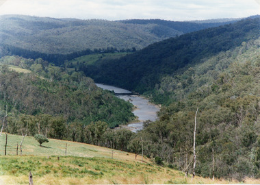
Photograph, Tambo Shire
Also second identical copyColour photograph of the Snowy River near The Basin, showing a river flowing between rocky banks, densely forested hills rising on both sides and into the far distance. Buchan Victoriaagriculture, animals, topography -
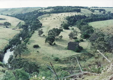 Sunbury Family History and Heritage Society Inc.
Photograph, Lochton Mill at Bulla, C1980s
The building in the photograph is a present day view of the former Lochton Mill which was built on a bend of Deep Creek in Bulla on 1856 on property owned by Captain William Morrison Hunter. Lochton Mill was one of a few mills that were set-up on the banks of Deep Creek in Bulla and Jacksons Creek in Sunbury.A non-digital coloured photograph of the ruins of a bluestone mill that was built on a bend of a river. It is an elevated view and clearly shows the river's course in the deep valley as well as the surrounding hilly countryside. lochton mill, bulla, deep creek, captain william morrison hunter, milling -
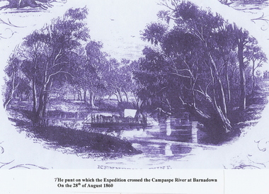 Bendigo Historical Society Inc.
Photograph - PUNT, CAMPASPE RIVER BARNADOWN
Photocopy: Punt on Campaspe River at Barnadown on August 28th, 1860. Used to ferry Bourke & Wills across the river. Picture is a photocopy of a sketch. The punt was possibly called KENNEY'S PUNT.topic, art, punt, camaspe river -
 Bendigo Historical Society Inc.
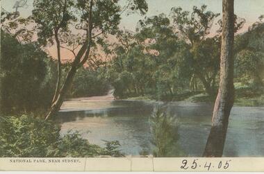
Postcard - Alice McGregor Postcard Collection, 1900 - 1920
Alice McGREGOR Born: 1908; unknown parents. Possibly adopted by the Salter family? Electoral Roll 1936: Highland Terrace Kangaroo Flat. Alice Mary Salter and William Robert Salter living together; presumed to be sister and brother. William Robert Salter was killed in a MVA in Bendigo in 1937 aged 26. In Victoria in 1938, Alice Mary Salter married James Thomas McGregor (born Victoria 1917, died Victoria 1983, buried Fawkner Cemetery) Lived: 1968; 22 Wade Street Golden Square Alice McGregor Died: 1999 aged 91 at Anne Caudle Centre, Bendigo Buried: Kangaroo Flat Cemetery See additional research. Postcard Album of Alice McGregor contained 86 post cards.Postcard Album of Alice McGregor containing 86 post cards. See 1400. Colour photo of a river scene in National Park near Sydney. Trees on both sides of river. Addressed to Miss A. Stapleton, Arcade, Bendigo Sender - not known Dated 25.4.05 postcard, collector, alice mcgregor -
 Ringwood and District Historical Society
Map - Public Land Sale by Thomas Ham, 2000 Acres for Sale - Crown Sections 20, 23, 24 - Ringwood, Victoria - 1855
Two 1850s surveyor's maps on cardboard backing showing area from Melbourne extending East beyond Bulleen and Nunawading. Detailed description of lots for sale and navigational directions to the property from Richmond by Thomas Ham, Victorian public servant, map maker, publisher, lithographer and original Ringwood land owner. Inset map enlarging area between Yarra River and Dandenong Creek, with southern boundary of allotments later forming part of Oban Road, North Ringwood.TRANSCRIPT: "This really valuable Property is now offered to the public for sale, in lots to suit purchasers at the Iow rate of £1 per Acre for 80 acres and upwards, and £1.10s per Acre for any smaller portion. Terms of payment Half Cash, Balance in 6 and 12 months, bearing 8 per cent interest. The Estate is well wooded with Gum, Cherry Tree and Stringy Bark, with Wattle in the valleys of the several creeks. Every lot is Staked and Trenched at the corners marked on the Plan thus - The Surveyor has carefully sub-divided the Property, in order to give every Farm a Creek for Water, Valley for Cultivation, and Hills for House and Grass Paddock. The ROADS have been very carefully laid out so as to give a firm, well drained, and nearly level road to each Homestead. Intending purchasers can readily find the property by the following directions, viz: Start from Richmond Bridge, at Hawthorne, then take the left-hand road to KEW. When at the "Woodman Inn", take the Cotham Road to the right, bearing due east, keep this Road, passing Trainor's "White Horse" Inn, and before you leave the fences, you will see calico bills (see margin) nailed to the Trees on the bush track leading to the Upper Yarra country, follow the Bills till you come to the SOUTH boundary line of the Property, which bears East and West (see Plan) where you will see Bills nailed up "THIS PROPERTY FOR SALE, etc." The Bills from Town lead direct to where Mr. Jull is erecting his Store, and arrangements have been made with him to show the lots to intending purchasers free of charge. At the respective corners of the lots the Bills are nailed up double, with numbers to denote the lot, and that the corner stake is adjacent. Any parties wishing to proceed to the property by way of BULLEEN will find Bills nailed on the Trees, commencing at the NEW INN, at "Wilson's Slip Rail." Keep this Track till you come to the Log Bridge, over the Deep Creek at Bloxhome's Paddock; go through the land now being cleared; keep the track over the hill till you come to an Iron House, you will then be on the property, which Iies to the North and East as per Plan. Follow the Bills till you come to Mr. Jull's Store, etc. etc. Further particulars can be had from the Agent for the Property. THOMAS HAM. " -
 Kew Historical Society Inc
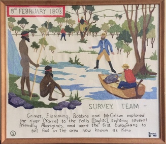
Textile - Bicentennial tapestry, 1. Survey Team, 8th February 1803, 1988
This is one of eight embroidered panels, completed during the 1988 Australian Bi-Centennial, and carried out under the auspices of City of Kew Council and the Kew Historical Society. Nearly 600 residents, including many children, participated in their production by adding a few or more stitches. A book records their names and the panels upon which they worked. Artist: Joy Stewart / Co-ordinator: Dorothy Benyei.1. Survey Team. A framed embroidery created by adults and children of the City of Kew as a Bicentennial project, based on a design by the artist Joy Stewart. Five of the six completed embroideries created in the project are/were displayed in the Kew Library. [The five embroidered panels have now been temporarily removed for conservation reasons].Inscription: "SURVEY TEAM 8th February 1803 / Grimes, Flemming, Robbins and McCallum explored the river (Yarra) to the falls (Dights), sighting several friendly Aborigines, and were the first Europeans to set foot in the area now known as Kew." Embroidered signature of the artist: "(c) JStewart, 1988"bicentennial project (kew), joy stewart, charles grimes expedition, australian bicentennial -
 Greensborough Historical Society
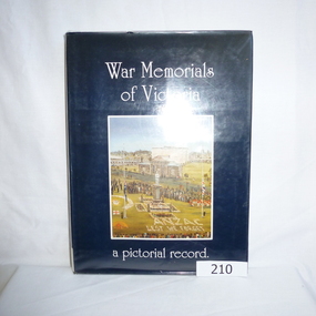
Book, War Memorials of Victoria: a pictorial record, 1994_
A photographic record of War memorials throughout Victoria. Includes 30 oil paintings of War memorials by Dacre Smith. Researched by Harold Bradley [et al]; compiled and designed by Max Parsons and Syd Trigellis-Smith.A record of over 1100 war memorials in Victoria; some photographs forwarded by RSL sub-branches.240 pages, illustrations (some colour).Stamps: Yarra Plenty Regional Library Service. Withdrawn [from collection]war memorials victoria, returned services league, syd trigellis smith, max parsons, dacre smith, harold bradley -
 Bendigo Military Museum
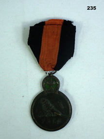
Award - BELGIUM MEDAL, Post 1914
Belgium Yser medal, commemorating a battle on the River Yser in 1914.military, belgium, commemorative yser river -
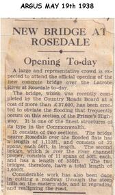 Phillip Island and District Historical Society Inc.
Newspaper clippings, 19/05/1938
Newspaper article in The Argus 19/08/1938Article on opening of new bridge over the Latrobe River at Rosedale.local history, documents, newspapers, bridges, rosedale, latrobe river, black & white newspaper clipping -
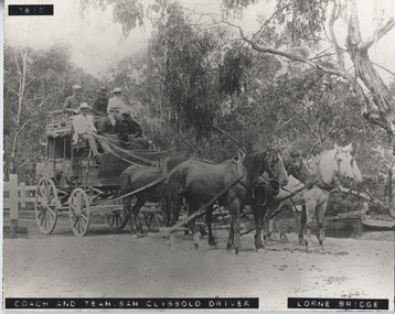 Lorne Historical Society
Photograph - Black and white photograph, mounted, Coach & Team, Sam Clissold driver. Lorne Bridge
Print mounted on board showing coach crossing Erskine RiverCoach & Team - Sam Clissold driver. Lorne Bridgebridge, coach, sam clissold, clissold, lorne bridge, horse driven, 1617, erskine, coach-driver -
Glenelg Shire Council Cultural Collection
Postcard - Postcard - Glenelg River Nelson, Victoria, n.d
Full colour postcard of the Glenelg River near Nelson, Victoria. -
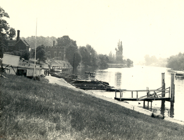 Federation University Historical Collection
Photograph - Photograph - Black and White, The Thames at Hampton Court
A photograph showing structures at the bank of the River Thames at Hampton Court.thames, hampton court -
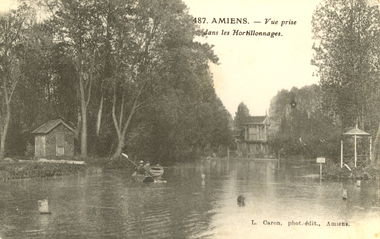 Federation University Historical Collection
Postcard - black and white, L. Caron, Amiens - vue prise dans les Hortillonnages, c1917
WW1 Holmes Family souvenirBlack and white postcard showing a boat on a river at Amiens, Francechatham-holmes family collection, amiens, france, world war one