Showing 11112 items
matching planning
-
 University of Melbourne, Burnley Campus Archives
Plan, Burnley Gardens. City of Richmond. Parish of Jika Jika - County of Bourke, 1927
Plan showing Burnley Gardens - bounded by Swan St to N, Yarra River to E, Richmond Park on S and W side. Photo-lithographed at Dept of Lands & Survey by W.J. Butson. Plan shows old orchard, fowl sheds, coops and yards, milking shed, silo,nursery, glasshouse, fattening pens, gardens and orchards area in S.W. corner.burnley gardens, orchards, sheds, nursery -
University of Melbourne, Burnley Campus Archives
Plan, Swan St. Entrance, 1988-1989
Found in file labelled, "Swan St. Entrance" Geoff Olive.(1) Correspondence between Mr Ron Hamilton, Manager, Tram Operations, Eastern Section and Steve Mullany, Lecturer. Includes plan of "Entrance to V.C.A.H. Burnley and Plant Research Institute." (2) Handwritten note dated 5 July 89. (3) Handwritten estimate of costs by Ian W(instone). (4) Photocopy of planting plan. Also see B11.0592. ron hamilton, vcah, burnley campus, steve mullany -
University of Melbourne, Burnley Campus Archives
Plan, John S. Jenkins, Plan showing land required for Road Purposes from the temporary reservaton for Horticultural Gardens at Richmond, 1880
Plan drawn by hand on tracing paper by John S. Jenkins, Town Surveyor, Richmond. "The land required is coloured red & it is proposed to add the part of Swan Street coloured blue to the gardens." Plan depicts land required for road purposes from the temporary reservation for Horticultural Gardens at Richmond. (Also framed and glazed copy B92.0539.) Scanned on CD.john s. jenkins, gardens, richmond, hoticultural society of victoria -
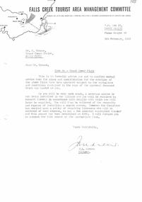 Falls Creek Historical Society
Document - Site 4a - Grand Coeur Flats Erection Approved Subject To Variations
Bob (Herman) Hymans (a former member of the Royal Netherlands Navy) was born in Bloemendaal, Holland on 30th September 1922. During World War II he fought against the Japanese in the Dutch East Indies (now Indonesia) and was imprisoned in Changi and on the Burma Railway. After gaining qualifications as a Ski Instructor, Bob arrived in Falls Creek in July 1950. Working as an Instructor and Supervisor at Bogong Lodge, Bob decided his future was in accommodation. He was successful in negotiating an indenture for land from the State Electricity Commission (SEC). It took Bob two years to build his Grand Coeur Chalet but, tragically, it was burned down in August 1961. Bob also built the first Chairlift in Australia. This was a single chairlift and the structure was built from wooden electricity poles. He was constantly full of new ideas and proposals for the village. Bob Hymans died on 7th July 2007. This Collection of documents and letters tells the story of Bob's endeavours to develop Falls Creek into the ski village it is today.This letter is significant because it reflects the relationship between Bob Hymans and the Management Committee.A letter from the Management Committee formally advising Mr Hymans that his plans and application to construct Grand Coeur Flats has been approved subject to variations enclosed. The required changes related to the installation of a sewerage in the Village. This meant that a septic tank did not have to be included in his plans, but the building must be connected to the new sewerage system and a fee paid.falls creek tourist area management committee, falls creek administration, parking regulations falls creek -
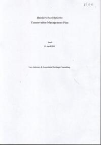 Bendigo Historical Society Inc.
Document - HUSTLERS REEF RESERVE CONSERVATION MANAGEMENT PLAN
Conservation management plan (112 pages) prepared by Lee Andrews & Associates, Heritage Consultants, in 2011, for the Hustlers Reef Reserve. The reserve cover the site of the former Great Extended Hustlers Mine site. Leigh McKinnons amendments to the plan are included with the document. History of the site, a physical survey and analysis, comparative analysis, cultural significance and conservation policy are addressed in the document.bendigo, mining, great extended hustlers mine site -
 Eltham District Historical Society Inc
Slide - Photograph, Eltham Shire Council, Plan of Subdivision, Part of Crown Portion 3, Parish of Nillumbik, County of Bourke, 1969
... planning ...35mm colour positive transparency blue Agfacolour Service plastic mountC5C, Delbridge, 4 lots, Rattray Road, 4 August 1969infrastructure, map, montmorency, planning, rattray road, subdivison lots, reichelt avenue -
 Eltham District Historical Society Inc
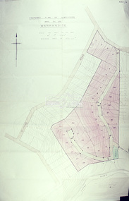
Slide - Photograph, Eltham Shire Council, Proposed plan of subdivision, Mrs Du Lee, Warrandyte, 1969
... planning ...35mm colour positive transparency blue Agfacolour Service plastic mountB2, Du Lee Subdivision, Research-Warrandyte Road, 4 August 1969infrastructure, map, planning, subdivison lots, du lee, glynns road, research-warrandyte road -
 Eltham District Historical Society Inc
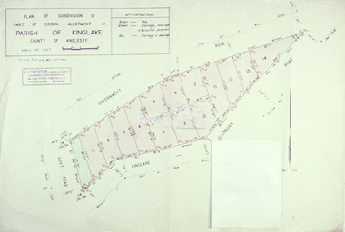
Slide - Photograph, Eltham Shire Council, Plan of subdivision of Part of Crown Allotment 41, Parish of Kinglake, County of Anglesey, 1969
... planning ...35mm colour positive transparency blue Agfacolour Service plastic mountC8, N. Johnson, Kinglake-Glenburn Road, 4 August 1969infrastructure, map, planning, subdivison lots, n. johnson, kinglake-glenburn road, kinglake -
 Eltham District Historical Society Inc
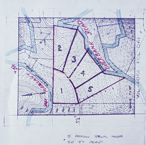
Slide - Photograph, Eltham Shire Council, Proposed subdivision of five approximately equal areas of 5 acres, Vol. 4061, Fol. 061, Overbank Road, North Warrandyte, 1969
... planning ...35mm colour positive transparency blue Agfacolour Service plastic mountD4, 55341, Peck subdivision, Mount Pleasant Road, 4 August 1969infrastructure, map, planning, subdivison lots, overbank road, mount pleasant road, north warrandyte -
 Eltham District Historical Society Inc
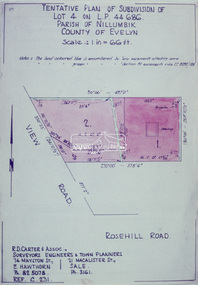
Slide - Photograph, Eltham Shire Council, Tentative Plan of Subdivision of Part of Lot 4 on L.P. 44 686, Parish of Nillumbik, County of Evelyn, 1969
... planning ...35mm colour positive transparency blue Agfacolour Service plastic mountB3 Robinson prelim subdivision, View Road, 4 August 1969infrastructure, map, planning, subdivison lots, view road, rosehill road, lower plenty -
 Eltham District Historical Society Inc
Document - Folder, Eltham Town Focus Group, 1996-1997
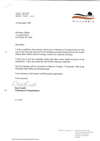
... planning ...Documents relating to a focus group brought together by the Shire of Nillumbik Chairman of Commissioners in 1996 to provide advise on the best long term use for the buildings and land situated between the former Eltham Shire Offices and Country Fire Authority buildings. These buildings are known as the Eltham War Memorial buildings located at 903-907 Main Road, Eltham. In May 2020, the Heritage Council Victoria did not recommend the site for inclusion in the Victorian Heritage Register. 11 pagesharry gilham collection, consultation, planning, eltham, eltham war memorial, eltham war memorial buildings, commissioners -
 Melbourne Tram Museum
Document - Article, Melbourne & Metropolitan Tramways Board (MMTB), "How our Tramways Developed", 1962
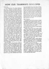
... planning ...Provides a brief history of public transport services in Melbourne - omnibus, cable, horse and electric tramways. Includes the Tramway Trusts, the formation of the MMTB, Preston Workshops, the W class tramcar. Gives figures for 30-6-1962. Yields a brief history of public transport in Melbourne, prepared by the MMTB 1962Three A4 photocopied pages with an article prepared by the MMTB titled - "How our Tramways Developed"tramcars, tramways, mmtb, preston workshops, planning, history, melbourne -
 Melbourne Tram Museum
Document - Report, Melbourne & Metropolitan Tramways Board (MMTB), "Chapel Street - Tram Routes - Data Sheets - Stop by Stop survey 1972", Dec. 1972
... Planning ...Report - Foolscap, card covers, red tape binding, 10 pages, titled "Chapel Street - Tram Routes - Data Sheets - Stop by Stop survey 1972" Maps running times and summary including a check across conductors journals. Dated Dec 1972, notes work done by L Hogan, W. TootellHas "Lees" in the top right hand corner and the title on the left side of the report.trams, tramways, routes, passengers, planning, development, chapel st -
Moorabbin Air Museum
Booklet - Navigation, Flight The Story of Electronic Navigation
... Planning ...Overview of electronic navigation for US FAA familiarization courses, circa 1960snon-fictionOverview of electronic navigation for US FAA familiarization courses, circa 1960scross country navigation, electronic highways, planning, preparation, tactical air navigation (tacan), facilities, radar -
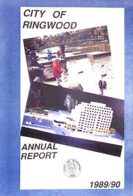 Ringwood and District Historical Society
Book - Annual Report, City of Ringwood Annual Report 1989/90, 1990
Third Annual Strategic and Organisational Management Plan Report to Council, outlining the activities of the organisation from 1st October 1989 to 30th September 1990. -
Federation University Historical Collection
Booklet, University of Ballarat Application to Become an IELTS TEst Administration Centre, c2009
University of Ballarat was renamed Federation University Australia. When the book was published the University of Ballarat had 7,500 international students from approximately 40 countriesA spiral bound 50 page booklet outlining a plan to establish an International English Language Testing System (IELTS) eAdministration Centre at the University of Ballarat.university of ballarat, international english language testing system, david battersby, letterhead, loddon campaspe multicultural services, city of ballarat, ballarat regional multicultural council inc, ethnic council of shepparton and district inc, english language project administrator -
Glenelg Shire Council Cultural Collection
Document - Renovation Plans - 23 Julia Street, Portland, P.S & G.S. Richards, Architects, Ballarat, Aug-37
Framed plans for alterations to 23 Julia Street, Portland, in colour, on beige paper attached to cream mount, then chipboard, commercial silver metal frame.julia street portland -
Ringwood and District Historical Society
Envelope, Packet: Tintern Church of England Grammar School - Foundation Stone Laying 1950, Plans, Letters, Clippings to 1994
Tintern Church of England Grammar School invitation to laying of foundation stone 1950; Booklet of plan for Tintern school; Letters, newspaper clippings to 1994 -
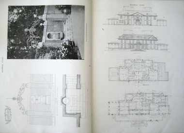 Federation University Historical Collection
Book, The work of Charles A. Platt, 1913
Charles Platt was born in New York in 1861 and died in 1933. He studied art at the National Academy of Design. In 1880, Charles went to Paris to study landscape painting and, while there, he travelled to Italy with his brother. Though he was influenced by Italian detailing, his designs were not copies of Italian gardens He was known as an architect and illustrator not as a garden designer. In 1880, he trained as an etcher with Stephen Parrish in Gloucester, Massachusetts. He also trained at the National Academy of Design and the Art Students League in New York and later in Paris with Gustave Boulanger and Jules Joseph Lefebvre at the Académie Julian. Charles exhibited his paintings and etchings and gained his first audience in Paris Salon of 1885. Betweem 1880 – 1890 , he made hundreds of etchings of architecture and landscapes. In 1900, Charles received a bronze medal at the Paris Exposition Universelle. In 1907 he designed a townhouse for Sara Delano Roosevelt on East 65th Street in New York. Eleanor Roosevelt called Charles A. Platt "an architect of great taste" who with the townhouse had "made the most of every inch of space." and in 1918, he designed the Freer Art Gallery in Washington. Book, Hard brown Cover. Title on the spine "The work of Charles A. Platt". Manufactural details on spine. Page no. 181. Black & white plates and plans. Stamped on page 43, 93, 123, 135, 161, 171"Picton Hopkins & Sons PTY.LTD"architecture design, domestic architecture, designs and plans, landscape gardening -
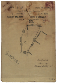 Federation University Historical Collection
Plan, Parish Of Ballarat Mining Lease applied for by J.H. Dill, 1907, 24/10/1907
Removed from Catalogue No 3601.Lease, plan and field notes showing the survey for the New Kohinoor Comapny Lease No 1205. Scale: 8 chains to 1 inch (1:6336)new kohinoor, survey, robert davidson, j.h. dill, dill, mining, ballarat, new koh-i-nor -
 Federation University Historical Collection
Plan, Landscape Plan for a courtyard at the Former Ballarat Gaol
Landscape Plan for a courtyard at the Former Ballarat Gaol, now part of Federation University SMB Campus. It is thought to have been designed by Brian McLennanformer ballarat gaol, landscape plan, brian mclennan, ballarat school of mines, smb campusarchitecture -
Federation University Historical Collection
Plan, Lease Application Field Notes No. 676. James Richardson, 28 January 1893
Foolscap size hand drawn ink plan near Morgan St and along Yarrowee Creek with State School and Weslyan Church central on page.Titled 'Correct Copy of Fieldnotes Lease Application No 676 JAMES RICHARDSON' also handwritten below this is 'Robert Davidson Surveyor 28th Jany/93' -
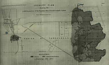 Federation University Historical Collection
Plan, Locality Plan Showing the relative position of the Poseidon, Nick o'Time and Ironbark Rushes
Plan Showing the relative position of the Poseidon, Nick o'Time and Ironbark Rushes from the Geological Seurvey of Victoria, Records, Volume 3, part 1.poseidon, nick o'time and ironbark tarnagulla -
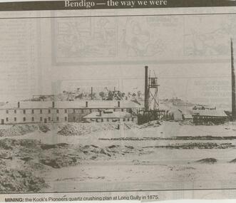 Bendigo Historical Society Inc.
Newspaper - JENNY FOLEY COLLECTION: MINING
Bendigo Advertise ''The way we were'' from 2000. Mining: the Kock's Pioneers quartz crushing plan at Long Gully in 1875. The clip is in a folder.newspaper, bendigo advertiser, the way we were -
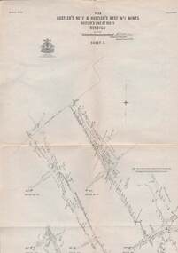 Bendigo Historical Society Inc.
Map - STRUGNELL COLLECTION: HUSTLER'S LINE OF REEFS, September 1913
Map, Hustler's Line of Reefs, Hustler's Reef & Hustler's Reef No1 Mines Plan, Bendigo.Plate No. XV11 (17).Bulletin No 33 Signed H.A.Whitelaw.Underground Survey Office, Bendigo.map, bendigo, hustler's reef & hustler's reef 1 -
Port Melbourne Historical & Preservation Society
Decorative object - Tile, Market shops, Bay Street, Port Melbourne, 1910s
Piece of green tile from the 1916 renovation of the market shops in Bay St, Port Melbourne (Ref. plans for the renovation, items 34.01-.02)built environment, business and traders -
Port Melbourne Historical & Preservation Society
Essay - Thesis, Competing ideas for the inner city, F Patricia Hawkins, Competing ideas for the inner city, 1991
Minor thesis submitted as part of the Master of Arts in Public History, Monash University, by Pat Hawkins, member of the PMH&PSCompeting ideas for the inner city - local responses to central planning initiatives in the City of Port Melbourne 1925 - 1985 by F Patricia Hawkins, 1991built environment, town planning, local government - city of port melbourne, f patricia (pat) hawkins -
Port Melbourne Historical & Preservation Society
Document - Reports, Department of Infrastructure to panel reviewing C5 amendment to Port Phillip Planning Scheme, Graham Deacons et al, 1999
The C5 Amendment aimed to create a framework for built form and development controls in the Port Melbourne Mixed Use Area undergoing conversion to residential development. Heritage overlays to protect heritage areas were also under review.Developer submissions to an independent Panel reviewing the C5 amendment to the Port Phillip Planning Scheme, 1999 Report from Deacons, Graham and James for Bectontown planning, built environment - civic, heritage, becton, fox hay timber and hardware pty ltd -
Bendigo Historical Society Inc.
Map - PORTION OF ELMORE ESTATE, 19/10/1920
Map: Portion of Elmore Estate, Parishes of Warragamba and Diggorra, County of Bendigo. Parish plan Canvas backed ( number 143 in Map Cupboard 1)map, bendigo, rural, elmore estate , warragamba, diggorra , county of bendigo. -
Bendigo Historical Society Inc.
Map - MAHER'S AND PRETTY'S ESTATE, 8/02/1926
Map: Maher's and Pretty's Estate, Parish of Toolamba West, County of Rodney. Parish plan Canvas backed. ( number 131 in Map Cupboard 1)map, rodney, rural, maher's , pretty's, toolamba west, county of rodney