Showing 23748 items
matching sardine-creek
-
 Bendigo Historical Society Inc.
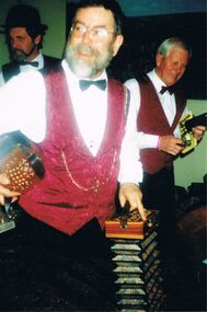
Photograph - PETER ELLIS COLLECTION: PETER ELLIS AND OTHERS
Colour photograph. Peter Ellis dark red waistcoat. Concertina. 2 other band members. Back of photo reads: Emu Creek Stan Symes Peter Ellis Des Skinner.photo, individual, peter ellis -
 Bendigo Historical Society Inc.
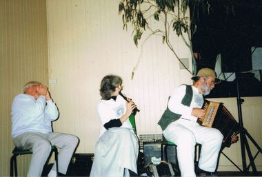
Photograph - PETER ELLIS COLLECTION: EMU CREEK BUSH BAND
Colour photograph. Man in corner playing harmonica, Woman playing recorder, Peter Ellis on accordion. Eucalyptus branch. All looking to right side of photograph Emu Creek Bush Bandentertainment, music, emu creek bush band -
 Bendigo Historical Society Inc.
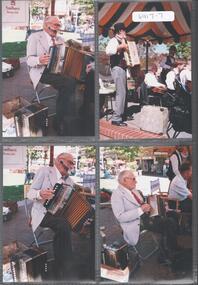
Photograph - EMU CREEK BUSH BAND COLLECTION: BENDIGO MALL
Four photographs of the Emu Creek Bush Band performing in the Hargreaves Street Malll, Bendigo. Three of these photos have the name of Oscar Wilde written on the back. accordianist, 98 years old. -
 Grantville History Group U3A
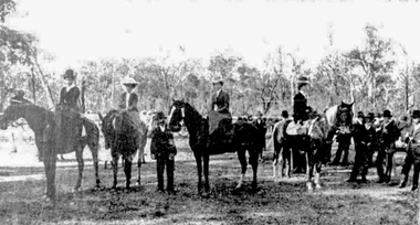
Photograph, The Grantville and Jeetho Agricultural Society's Annual Show: February 1906, 1906
The Grantville Show 1906b: The Lady's Hackney Competition (l-r Miss Alma Chapman (Almurta), Miss Grant (Almurta), Mrs Clare Atkins (Strezlecki Creek), Miss McMahon (Bena) -
 Bendigo Historical Society Inc.
Postcard - Alice McGregor Postcard Collection, 1900 - 1920
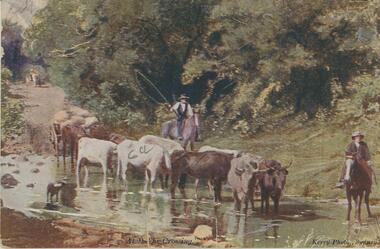
Alice McGREGOR Born: 1908; unknown parents. Possibly adopted by the Salter family? Electoral Roll 1936: Highland Terrace Kangaroo Flat. Alice Mary Salter and William Robert Salter living together; presumed to be sister and brother. William Robert Salter was killed in a MVA in Bendigo in 1937 aged 26. In Victoria in 1938, Alice Mary Salter married James Thomas McGregor (born Victoria 1917, died Victoria 1983, buried Fawkner Cemetery) Lived: 1968; 22 Wade Street Golden Square Alice McGregor Died: 1999 aged 91 at Anne Caudle Centre, Bendigo Buried: Kangaroo Flat Cemetery See additional research. Postcard Album of Alice McGregor contained 86 post cards.Postcard Album of Alice McGregor containing 86 post cards. See 1400. Colour photo of 2 stockmen on horseback guiding a bullock drawn wagon across a creek. Entitled At "The Crossing" Addressed to Miss A. Stapleton, Bendigo, Victoria Sender - Jessie MacCallum PO stamp dated May 1920 postcard, collector, alice mcgregor -
 Hume City Civic Collection
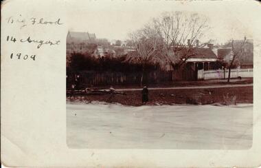
Photograph, 14/08/1909
The Jackson Creek flooded on 14 August 1909 when the creek was 32 feet above sea level.A sepia photograph of Powlett Street in the big flood of 1909. Unmounted postcardjackson's creek, powlett street, sunbury, floods, gregor, bob, billinghurst, beryl, francey, sandra, alex, our lady of mt carmel church, churches, 1909, george evans collection -
 Clunes Museum
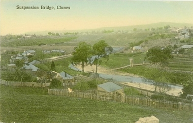
Photograph - POSTCARD, PRINTED IN GERMANY
THE SUSPENSION BRIDGE OVER CRESWICK CREEK, PLACED AT CREEK PARADE CLUNES, WAS WASHED AWAY IN A SEVERE FLOOD.COLOURED PHOTOGRAPH OF SUSPENSION BRIDGE CLUNESSUSPENSION BRIDGE - CLUNESlocal history, document, postcard, bridges -
 Falls Creek Historical Society
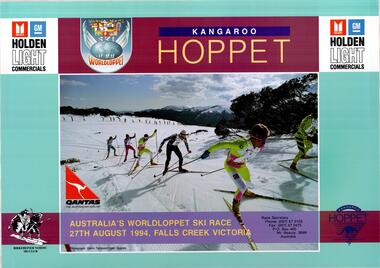
Poster - Kangaroo Hoppet 1994
The Kangaroo Hoppet is Australia’s premier long distance cross country ski race, and a member of the Worldloppet series of international cross country ski events. The first race at Falls Creek was held in 1979 under the name of “Australian Birkebeiner”. It was a 21km race with about 80 participants organised by the Birkebeiner Nordic Ski Club of Mount Beauty. The course started and finished at Falls Creek Alpine Resort and took participants out into the Bogong High Plains. After running the event for 10 years, it was decided they should become part of the Worldloppet series of marathon ski races. Representatives from the Birkebeiner Nordic Ski Club and the Australian Ski Federation attended the Worldloppet Annual Meeting in Finland in June 1990 to put the case for the acceptance of an Australian event into the Worldloppet series. Before being admitted, they had to demonstrate that the Birkebeiner Club could run a world class event, so three months later in August 1990 a 42km event named the Australian International Ski Marathon was held at Falls Creek together with a 21km Birkebeiner race and a 7km event called the Birkebeiner Lite. The event was approved by delegates from USA, Norway and Austria, in 1991 Australia became the 12th member of Worldloppet, with the condition that there had to be a name change. After some late night discussion allegedly involving red wine from North East Victoria the main event became the 42km Kangaroo Hoppet, with the minor events being the 21km Australian Birkebeiner, and 7km Joey Hoppet. In the winter of 1991, the first Kangaroo Hoppet was held. It was a great success and has been a regular fixture on the international ski calendar ever since. It features the main 42km event as well as a 21km event and a 7km event. The Hoppet brings the Australian snowfields to an international audience. In 1994 the Men's Winner was Peter Schlickenreider from Germany in a time of 1:41:02. The winner of the Women's event was Antonina Ordina of Sweden in a time of 1:53:19.This poster is significant because it documents an event which brings international attention to Falls Creek and the surrounding region.A large coloured poster featuring a central image of competitors in the Kangaroo Hoppet with dates and logos.At top: Logo for Holden Light Commercials on either side of text KANGAROO HOPPET and WorldLoppet Logo Across bottom of image: AUSTRALIA'S WORLDLOPPET SKI RACE/ 27th AUGUST 1994, FALLS CREEK VICTORIA Race Secretary / Phone: (057) 57 3103 / Fax (057) 57 2475 / P.O. BOX 400 Mt. Beauty 3699 Australia Photograph: Glen Tempest/Open Spaces Bottom Left: Logo of the BERKENBEINER NORDIC SKI CLUB Bottom Right: Kangaroo Hoppet Logokangaroo hoppet, worldloppet events, falls creek, mt. beauty -
 University of Melbourne, Burnley Campus Archives
Album - Black and white and colour prints, negatives and 35mm slides, Found in former Staff Room, Collection of Staff Photogeraphs, 1994-2000
Collection of photograph envelopes which had belonged to staff members. Some are photographs from excursions, other teaching material - plants. Some labelled: Ruth Upper Merri Creek - negatives and prints; Merri Creek - negatives and prints; Merri Creek Panorama - prints; Merri Creek Posters - negatives and prints; Western District Exhibition, labelled - negatives and prints; Mt Ridley (Excursion?) - negatives and prints; Energy Education Centre 15 November 1995; Gardens - Spring 1995 negatives (mostly James Hitchmough Native Grasslands and Luffmann Ponds); Student Party June 1994 - negatives; Pot Trial - negatives and prints; Miscellaneous plant trials, Centenial Centre Shop, Arborists, Plants, Excursions - negatives; Excursions , 1 year 2000 - negatives and prints; Orchard (older) - black and white negatives and prints; Arborists - negatives and prints; Staff, Graduate students - negatives and prints; Miscellaneous: Plants, Plant database (Jill Kellow) - negatives, slides and prints.staff, excursions, teaching material, merri creek, mt ridley, energy education centre, student party, pot trial, centenial centre shop, arborists, plants, graduates, students, plant database, jill kellow, orchard, james hitchmough grasslands, horticulture shop -
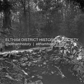 Eltham District Historical Society Inc
Negative - Photograph, J.A. McDonald, Hurstbridge Water Scheme, 11 May 1961
Downstream view of wall in creek and leak 11 May 1961 http://wikimapia.org/10473910/Running-Creek-ReservoirRecord of various Shire of Eltham infrastructure works undertaken during the period of 1952-1962 involving bridge and road reconstruction projects, sometimes with Eltham Shire Council Project Reference numbers quoted. It was during this period that a number of significant improvements were made to roads and new bridges constructed within the shire that remain in place as of present day (2022). In many situations, the photos provide a tangible visible record of infrastructure that existed throughout the early days of the Shire. The album was put together by or under the direction of the Shire Engineer, J.A. McDonald.infrastructure, road construction, shire of eltham, 1961-05-11, hurstbridge water scheme -
 Ringwood and District Historical Society
Photograph, Bridge connecting Adelaide St. and Reynolds Av., Ringwood. pre 1931
Written on back of photograph, "Bridge connecting Adelaide St. and Reynolds Av. Washed away in 1931 by the flooded Mullum Creek. Looking towards Reynolds Ave." -
 Ringwood and District Historical Society
Photograph, View of Glenvale Road, Ringwood. Warnes Road in left background 1964
See Also #25Written on back of photograph, "1964 - View of Glenvale Road. Supplied by Garrett Gundry. Warnes Road in left background. Deep Creek Road in centre background." -
 Ringwood and District Historical Society
Photograph, View of Glenvale Road, Ringwood 1964
See Also #25Written on back of photograph, "1964 - View of Glenvale Road. Supplied by Garrett Gundry. Warnes Road in left background. Deep Creek Road in centre background." -
 Ringwood and District Historical Society
Photograph, Building the old Ringwood baths in Ringwood St 1934
Black and white photograph. 2 copies- 1 large, 1 small.Typed below photograph, "Building the old Ringwood baths in Ringwood St. The car is in Ringwood St. and the bridge over the Mullum Creek can be seen. 1934". -
 Halls Gap & Grampians Historical Society
Document - B/W article (magazine/newspaper), C 1930s
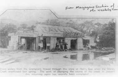
A photo, that appeared in the magazine section of the Weekly Times in 1937, of Taylor's General Store and Cafe after a flood of the Stoney Creek. The creek flowed through the store at the height of the flood. The course of the creek was changed after this flood to prevent this happening again.A newspaper cutting. It shows a building with three women standing in front of it. The building has TAYLOR painted on the roof and a sign saying "Store & Cafe" there is a large pool of water in the foreground. Trees and hills can be vaguely seen in the background.buildings, shops, natural disasters, floods -
 Kiewa Valley Historical Society
Folder - Bogong High Plains and Falls Creek, 1960's and 1970's
Tourism on the Bogong High Plains developed after/during the State Electricity Commission of Victoria construction of the Kiewa Hydro Electric Scheme.With the completion of the power stations on the Bogong High plains, tourism has created a new focus and different infrastructure/lifestyle for the community.A blue folder with a collection of papers & booklets on: 1. Discovery of Bogong High Plains 1962 2. SECV Discovery of Bogong High Plains 1968 3. SECV Kiewa Hydro Electric Scheme 1911 - 1961 4. Newspaper cutting - Mt Beauty 1974 5. McKay Creek Power Station and Clover Power Station 6. Falls Creek and Mt Beauty Tourist Map & brochures 7. Bogong High Plains Tour 1973bogong high plains; falls creek; tourism; -
 Bendigo Historical Society Inc.
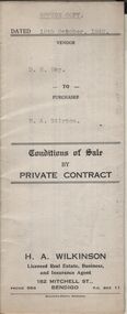
Document - H.A. & S.R. WILKINSON COLLECTION: CONTRACT OF SALE
Conditions of sale by private contract dated 19th October, 1942 between D.R. Hay (seller) and H.A. Stirton (buyer) for land situate corner Creek and Hamann Streets, Bendigo, having a frontage of 85 links to Hamann Street by a depth of 134 links to Creek Street and adjoining allotments 6 and 4, and described in right to occupy residence area title No. 5429, together with 4-roomed weatherboard dwelling and all sundry. Price 270 pounds.organization, business, h.a. & s.r wilkinson real estate -
 Bendigo Historical Society Inc.
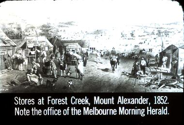
Slide - DIGGERS & MINING. STORES AT THE DIGGINGS, c1852
Diggers & Mining. Stores at the diggings. Stores at Forest Creek, Mount Alexander, 1852. Note the office of the Melbourne Morning Herald. Slide show the busy area of Forest Creek stores. From left to right the signs that can be read: ? Argus Office, Gold bought and sold here, Bryce Ross's Newspaper and General Agency Office, STG '52 marked at bottom left corner of picture. Markings: 7 994.LIF. 5. Used as a teaching aid.hanimounteducation, tertiary, goldfields -
 Glenelg Shire Council Cultural Collection
Photograph - Photograph - Portland scene, c. 1970
Photographic print of a rephotographed photograph. Image shows lower north slope Observatory Hill, fence along base, then wooden bridge over Salt Creek that drains into bay, near the Spit Portland.Front: 'Bridge over Portland drain' - green ink -
 Ringwood and District Historical Society
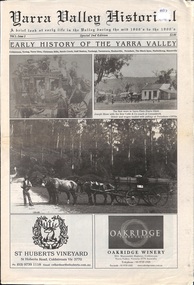
Newspaper, Yarra Valley Historical - A brief look at early life in the Yarra Valley during the mid 1800s to the 1900s (issued circa 2010)
Early History of the Yarra Valley (Vol l Issue 2) Coldstream, Yering, Christmas Hills, Steels Creek, Gulf Station, Toolangi, Tarrawarra, Healesville, Fernshaw, The Black Spur, Narbethong, Marysville. -
 Federation University Historical Collection
Photograph, Gold Dredge
Black and white mounted photograph of a dedge floating on a body of water which has a creek flowing into it, and rolling hills in the background. The buildings associated with a mine or factory are shown on the top left hand side. Signed "Martin ?ish Victoria St" verso "R.H. Brooke, "Callantina Villa", Glenferrie Rd Sthdredge, dredging, mining, river, callantina villa, gold mining -
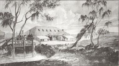 Bendigo Historical Society Inc.
Photograph - POST OFFICE AND SURVEY OFFICE BENDIGO
Black and white photocopy enlarged. Sketch of Post Office, Survey Office Bendigo and other building. Wooden bridge over creek. Inscriptions: on front - rubber stamp 'Bendigo Historical Society Inc.'buildings, post office -
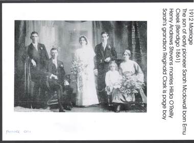 Bendigo Historical Society Inc.
Photograph - WEDDING PHOTO: HENRY STEVENS AND HILDA O'REILLY
black and white copy of photo: image shows 1912 marriage of Henry Andrews Stevens and Hilda O'Reilly. Henry is the son of early pioneer Sarah McDowall, born Emu Creek ( Bendigo 1861 )person, group, henry stevens, hilda o'reilly, emu creek, sarah mcdowall, hilda o'reilly, reginald clark. -
Bendigo Historical Society Inc.
Map - FRED COWIE COLLECTION: AERIAL MAPS OF HEATHCOTE/EPPALOCK
Map, Heathcote A3, Aerial Survey of Victoria, Photo-map prepared by Department of Crown Lands.Campaspe River , Wild Duck Creek, Knowsley, Eppalock Weir.Fred Cowie,46 McIvor Rd ,Bendigo.map -
 Hume City Civic Collection
Photograph, c 1980s
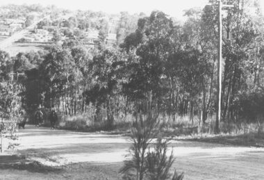
The photograph although recently taken shows the original settled area in Sunbury, which included Goonawarra Vineyard and Macedon Street which was once the business centre of Sunbury township before the railway was established.A coloured photograph of Sunbury Township looking west from above Jacksons Creek and Goonawarra Winery. Macedon Street can be seen in the middle distance and Mt. Holden and Burke Hill are across the skyline.sunbury township, mt. holden, burke hill, francis, james goodall, barnier, john, jacksons creek, goonawarra winery, george evans collection -
Lakes Entrance Regional Historical Society (operating as Lakes Entrance History Centre & Museum)
Book, Mc Kee, Eileen, The Alps at the Crossroads, 1996
A potted family history put together for descendants of Ned and Lucy Smith, who spent a major period of their lives at Genoa and Cabbage Creek in East Gippsland. Contains basic family tree and illustrations.settlers, genealogy -
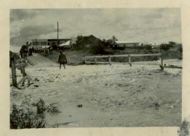 Sunshine and District Historical Society Incorporated
Photograph (1954) - Flooded Bridge, 1954
1954 Photograph of KOROROIT CREEK in flood and overflowing the DERBY RD BRIDGE in Sunshine. Short time later this bridge was declared unsafe and closed to vehicle traffic. The Sunshine Technical School building is in the background.derby rd bridge, flood, kororoit creek, sunshine technical school, 1954 -
 Clunes Museum
Photograph, JEAN GORDON GOVERNMENT PRINTER. MELBOURNE
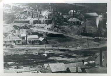
BLACK AND WHITE PHOTOGRAPH OF PORT PHILLIP MINE - LOOKING NORTH FROM WEST SIDE OF CAMP HILL.TULLAROOP CREEK WITH CAMP STREET FORD, PORT PHILLIP HOTEL AND MINING BUILDINGS AND MINING CONSTRUCTIONSphotographs, mining, port phillip mine -
 Clunes Museum
Photograph
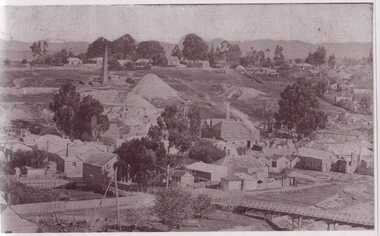
BLACK AND WHITE PHOTOGRAPH OF CLUNES TOWNSHIP. SMOKE STACKS, MULLOCK HEAPS, TWO POPPET HEADS, TWO BRIDGES OVER CREEK, DWELLINGS. SEVERAL LARGE TREES AND SMALLER TREES IN TREE GUARDS.local history, photography, photographs, clunes township -
Whitehorse Historical Society Inc.
Document, Bridge divides locals, 2010
Report of proposal by Deakin University, Burwood Campus to construct a 200m. bridge over Gardiners Creek to connect two portions of its campus, and comments from West Elgar Residents Association spokeswoman.Report of proposal by Deakin University, Burwood Campus to construct a 200m. bridge over Gardiners Creek to connect two portions of its campus, and comments from West Elgar Residents Association spokeswoman.Report of proposal by Deakin University, Burwood Campus to construct a 200m. bridge over Gardiners Creek to connect two portions of its campus, and comments from West Elgar Residents Association spokeswoman.west of elgar residents association, gardiners creek, deakin university. burwood campus