Showing 123968 items matching "main-road"
-
 Stawell Historical Society Inc
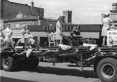
Photograph, Red Cross float in Main Street in front of Mr R.J. & Mr L.A. Heslop Shop and Electricity Showroom
Red Cross in street procession of floats. In Main Street in front of R.J. & L.A. Heslop Shop and Electricity Showroom.stawell medical -
 Stawell Historical Society Inc
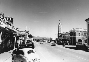
Photograph, Stawell lower Main Street looking towards Grampians 1960's
B/W 1960's Main Street, Town Clock, bank of Australia, Café and Grampians Mountains in background. streetscape -
 Stawell Historical Society Inc
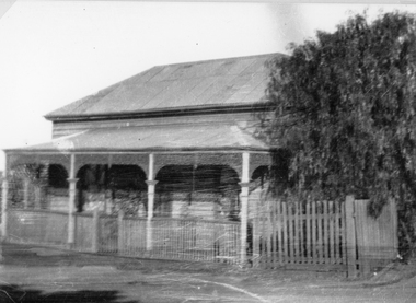
Photograph, Upper Main Street Stawell with a Weatherboard Home – Reeve Family
The Photgraph of a Weatherboard Home which was situted Upper Main Street on the left side of the street– It was the home of the Reeve Family. Black and White photgraph of a weatherboard home with veranda across the front, around which a wooden fence and gateway, onto the street.stawell, reeve -
 Greensborough Historical Society
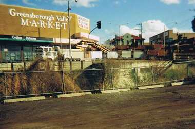
Photograph - Digital image, Para Road Greensborough from the Station, 1975_
Photograph of the intersection of Para Road and Main Street Greensborough circa 1975. Shows the Greensborough Valley Market on the corner and Greensborough Hotel in background. Taken from the Station, the train line can be seen in the foreground.Digital copy of colour photograph.greensborough valley market, greensborough station, para road, main street greensborough -
 Ringwood and District Historical Society
Photograph, Ringwood Cool Stores Corner Main St. and Wantirna Rd1958
Black and white photograph of Ringwood Cool Stores. Photographs shows wooden buildings with gently sloping peaked corrugated iron roofing. Picket fence at front of building with "Vote NO" painted.Typed below photograph, "Ringwood Cool Stores. Present site of Ringwood Clock Tower, 1958". Written on backing sheet, "Cool Store 1958. Corner Main St. and Wantirna Rd. Now site of Clock Tower". -
 Ringwood and District Historical Society
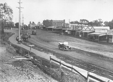
Photograph, Maroondah Highway Central, Ringwood. Main street, Ringwood c1924. showing cars and horse-drawn carriages in front of shops - undated but possibly c1924
Black and white photograph (2 copies- 1 large, 1 small)Written on rear of backing sheet of large copy: "Early days of Ringwood commercial centre. Present frontage of Eastland to Maroondah Highway." Image shows Main Street with motor cars and horse drawn vehicles in front of shops. -
 Ringwood and District Historical Society
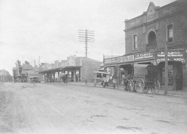
Photograph, Maroondah Highway Central, Ringwood. Coffee Palace and shops along Main Street between Adelaide Street and Melbourne Street. c1920's
Black and white photographWritten on back of photograph: "Land values - Main Street, Ringwood - land worth £50 pounds a foot." Image is taken from a land sale brochure and shows cars and horse drawn vehicles parked in front of buildings. -
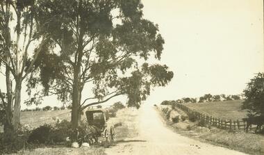
 Lorne Historical Society
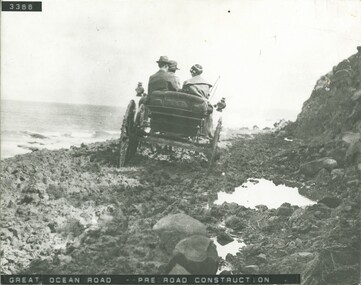
Photograph, Great Ocean Road, pre road construction
Photograph pre construction of the Great Ocean Road showing three adults and horse drawn carriage. pre-road-construction. horse-drawn-carriage. g.o.r -
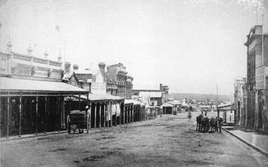
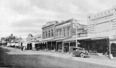 Stawell Historical Society Inc
Postcard, Front Cover, Upper Main Street Stawell looking East & & looking West -- 3 Photos -- Postcards 1920's
Views of Stawell. INCLUDES view of Main Street looking East showing from right Strangio & Pizione fruit shop. Sun Printing Works. Tea Rooms. King. Carters Boot Shop. Taylor. Bull and Mouth in distance. Car visible. ALSO Main Street Looking West showing from right Norman A Harding Taylor and Outfitter. Geo Mitchell & Sons stawell businesses streetscape -
 Ringwood and District Historical Society
Photograph, Road to 'Quambee (undated)
With two horses attached to trap, feeding.Typed below photograph, "Road to 'Quambee'". -
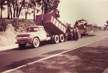 Kew Historical Society Inc
Photograph, Public Works, Road Construction, 1950s
An original photograph donated to the Kew Historical Society by the City's Engineering Department before the amalgamation of Kew into the City of Boroondara in 1994.While not all of the photographs are of Studley Park, Kew or East Kew, each photo provides a fine snapshot of the work of local government engineering departments of the period. They reveal they types of labour conducted, the techniques used and the equipment and machinery in the possession of the local government authority.Public works. Roadmaking machinery in the 1950s using a tip truck and other equipment. Inscription on reverse: "Road making. Date?" city of kew (engineering department), road construction maintenance -
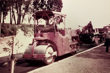 Kew Historical Society Inc
Photograph, Public Works, Road Construction, 1950s
An original photograph donated to the Kew Historical Society by the City's Engineering Department before the amalgamation of Kew into the City of Boroondara in 1994.While not all of the photographs are of Studley Park, Kew or East Kew, each photo provides a fine snapshot of the work of local government engineering departments of the period. They reveal they types of labour conducted, the techniques used and the equipment and machinery in the possession of the local government authority.Public works. Roadmaking in the 1950s using a steam roller. Inscription on reverse: "Road making. Date?" city of kew (engineering department), road construction building -
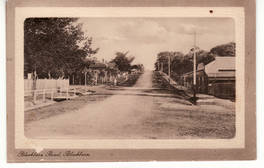 Whitehorse Historical Society Inc.
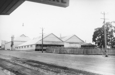
Postcard, Blackburn Road Blackburn circa 1914, 1914
Black and white postcard titled 'Blackburn Road, Blackburn'. Scene shows Blackburn Road looking South from railway gates. Shop on one corner. Unmade road.hooke, albert arthur, blackburn road, blackburn, janet emily -
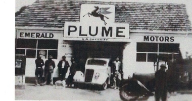 Emerald Museum & Nobelius Heritage Park
Photograph, Emerald Motors, Early 1950s?
The site of H A ("Herbie") Sherriff's business, Emerald Motors, was a former blacksmith's shop on the corner of Main Road and Kilvington Road. The sign over the shop bears the word "PLUME": This was a "motor spirit" (fuel) produced by Standard Oils and sold in Australia 1916-1954.The signage and the two cars visible (one late model and one early) establish the time the photograph was taken. Black and white photograph of shopfront of H A Sherriff's Emerald Motors business. White car (Austin?) visible in workshop entrance, dark older car in profile on right. Sign over garage shows Mobil "Pegasus" logo and word "PLUME" . Five men and a dog standing around casually, a sixth man (Herbie Sherriff?) posing next to white car. emerald motors, herbie sherriff -
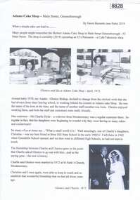 Greensborough Historical Society
Article, Dawn Bennetts, Adams Cake Shop - Main Street Greensborough, 2019
A short story about Adams Cake Shop in Main Street Greensborough in the 1970s and some coincidences about a member of staff.Article, 1 p., illus.adams cake shop greensborough, glenice dyke, dawn petts, dawn bennetts -
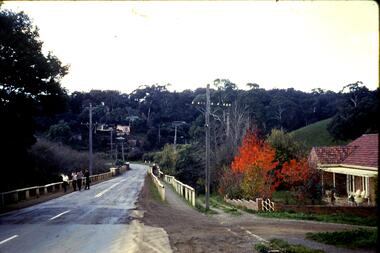 Greensborough Historical Society
Slide, Fred Harris, Main Street, old river bridge Greensborough, 1949c
Taken about 1949, this colour slide shows Main Street Greensborough crossing the Plenty River via the 'old' bridge.1 photographic slide in yellow Kodak packet.Name of donor and title of slide written on outside of packetmain street greensborough, plenty river, main street bridge -
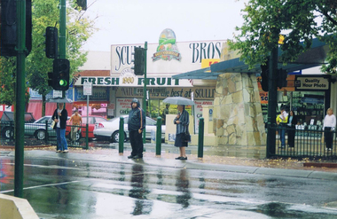 Greensborough Historical Society
Photograph - Digital image, Frank Solomon, Sculli Brothers Fresh Fruit shop, Main Street Greensborough, 04/06/2010
Sculli Brothers Fresh Fruit shop, Main Street Greensborough. Sculli's now operate from a store in Greensborough Plaza.Digital copy of colour photographmain street greensborough, sculli family -
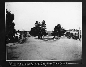 Stawell Historical Society Inc
Photograph, Stawell Hospital under construction looking from the Main Street and Wimmera Street intersection
View of Stawell Hospital under construction from Main Street and Wimmera Street intersection. Stawell Baths in centre of photo.stawell hospital -
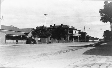 Stawell Historical Society Inc
Photograph, Victoria Coffee Palace & Stawell Coffee Palace formerly the Castlemaine Hotelin Main Street Stawell from Victoria Street 1945
Victoria Coffee Palace & Stawell Coffee Palace formerly Castlemaine Hotel, Main Street from Victoria Street 1945stawell streetscape -
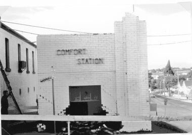 Stawell Historical Society Inc
Photograph, Toilet Block / Comfort Station on the corner of Main & Wimmera Street after car crashed into it c1970's
Toilet Block / Comfort Station Cnr. Main Street & Wimmera Street after car crashed into it. Early 1970's.stawell -
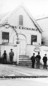 Stawell Historical Society Inc
Photograph, Mining Exchange beside Commercial Hotel in Upper Main Street Stawell
Mining Exchange beside Commercial Hotel Upper Main Street Stawell. Opened during mining boom 1894-1895stawell business -
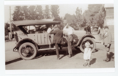 Mt Dandenong & District Historical Society Inc.
Photograph, Car in Sassafras Main Street
Two men looking closely at a car in Main Street of Sassafras. Probably during the visit of Edward, Prince of Wales in 1920.Copy of a black and white photo showing two men and two children standing near a car. The men looking at the car, the children looking t the ca,era.sassafras, car -
 Stawell Historical Society Inc
Photograph, Central Main Street Stawell looking West with the Large brick building on right later occupied by Coles, Fosseys and Lyal Eales
Central Main Street looking West. Large brick building on right later occupied by Coles Fosseys and Lyal Ealesstawell business streetscape -
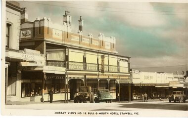 Stawell Historical Society Inc
Postcard, Bull & Mouth Hotel in Main Street Stawell with Dane Bros on the right c1950 -- Postcard -- Coloured
Bull & Mouth Hotel Main Street Stawell Built 1907. Dane Bros on right Murray Views No. 16. c1950stawell streetscape -
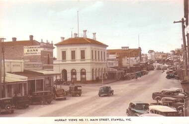 Stawell Historical Society Inc
Photograph, Main Street Stawell looking East c1940 -- Postcard -- 2 Photos -- 1 Coloured
2 Postcards Main Street Looking East c1940 Murray Views No 11. One Coloured one B/Wstawell streetscape -
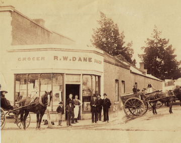 Stawell Historical Society Inc
Photograph, Mr R. W. Dane, Grocer & Baker on the corner Main Street & Layzell Street from P.C. News Supplement 1888 -- Sketch
R. W. Dane Grocer & Baker corner Main Street and Layzell Street from P.C. News Supplement 1888stawell businesses -
 Stawell Historical Society Inc
Photograph, Mitchell’s Shop Staff in Main Street Stawell when shop closed 1987 -- Multiple Photos
Framed series of nine photos in Black frame of Mitchell’s Shop Staff Main Street Stawell. Shop closed 1987stawell business shops -
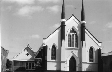 Stawell Historical Society Inc
Photograph, Stawell Methodist Church in Main Street Stawell showing the Modenised Sunday School building
Stawell Methodist Church. Main Street Stawell. Sunday school has had modern front added. Wesley Centre.stawell -
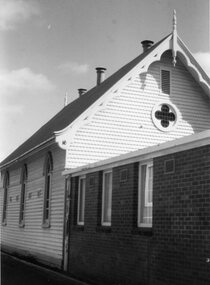 Stawell Historical Society Inc
Photograph, Stawell Methodist Church in Main Street Stawell showing the Wesley Centre from Joyce Lane
Stawell Methodist Church. Main Street Stawell. View of Wesley Centre from Joyce Lane beside Town Hall.stawell -
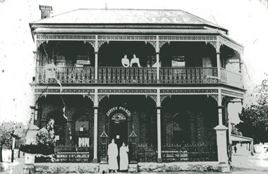 Stawell Historical Society Inc
Photograph, Stawell Coffee Palace formerly the Castlemaine Hotel in Lower Main Street with Staff at front and on verandah c1905
Stawell Coffee Palace formerly Castlemaine Hotel, Lower Main Street with Staff at front and on verandah. A.H. Bush c1905.stawell