Showing 1796 items
matching “mm”
-
 Running Rabbits Military Museum operated by the Upwey Belgrave RSL Sub Branch
Ammunition
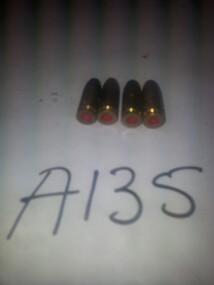
5 x 9 mm drill rounds X 4ammunition, ww2, army -
 Running Rabbits Military Museum operated by the Upwey Belgrave RSL Sub Branch
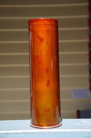
Shell Casing
105 mm M14B1 High Explosive Artillery Shell casingammunition, vietnam, army -
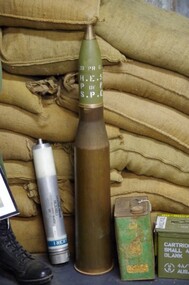
 Running Rabbits Military Museum operated by the Upwey Belgrave RSL Sub Branch
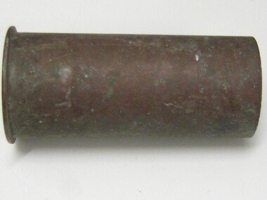
Shell
QF 75 mm Mountain Gun Model II Shellammunition, ww1, army -
 Running Rabbits Military Museum operated by the Upwey Belgrave RSL Sub Branch
Ammunition
Ammunition 7.62 mm X 51 Armourers Dummy X2ammunition, general -
 Running Rabbits Military Museum operated by the Upwey Belgrave RSL Sub Branch
Projectile & Shell
Centurian Tank Cannon Round 20lb 83.4 mm HESammunition, vietnam, army -
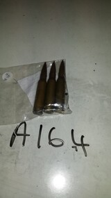 Running Rabbits Military Museum operated by the Upwey Belgrave RSL Sub Branch
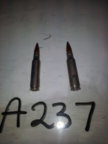
Ammunition
7.62 mm (3 - one added 11/5/17)ammunition, vietnam, army -
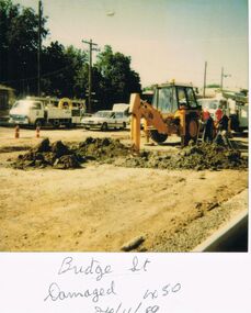 Bendigo Historical Society Inc.
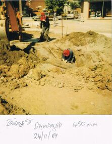
Photograph - CASTLEMAINE GAS COMPANY COLLECTION: PHOTO BRIDGE STREET, 24/11/1989
Bridge Street Damaged 450 mm. - 24/11/1989Polaroidorganisation, industry, gas and fuel -
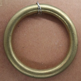 Trafalgar Holden Museum
Equipment - Horse ring, c1900
imported for the use on horse bridles and other equipment for civilian agriculture and military during 19th and 20th centuriesimported and sold by Holden and Frost55 mm diameter brass ring used in harness makingnilequine, military, agriculture, civillian, circa 1910, horse ring -
 Bendigo Historical Society Inc.
Photograph - CASTLEMAINE GAS COMPANY COLLECTION: PHOTO BRIDGE STREET, 24/11/1989
Bridge Street Damaged 450 mm. - 24/11/1989Polaroidorganisation, industry, gas and fuel -
 Eltham District Historical Society Inc
Document - Folder, Jim Connor et al, Eltham Gateway, 1987
The Eltham Gateway Group (EGG) was established about 1987 by some Eltham residents concerned for the development of the Eltham Gateway, defined as that historically and environmentally sensitive region of land along Main Road, Eltham extending from the roundabout at Fitzsimons Lane to Dudley Street, Eltham. The gateway was a unique urban area with a strong sense of character that provided a distinctive entrance to the Eltham Town Centre. The intention of this group was to support development that preserved both the natural and historic features of the gateway region. It encouraged development sympathetic to Eltham’s traditional association with the arts and natural environment. The group was initiated in response to a planning application in December 1986 to redevelop the then Mobil service station site at 729 Main Road, Eltham on the corner of Brougham Street. This group worked with and encouraged the Eltham Shire Council to consider rezoning to protect the gateway area. A detailed Eltham Gateway Study undertaken by Tract Consultants assisted with the establishment of the Eltham Gateway Zone, the Eltham Gateway Policy and the Eltham Gateway Design and Siting Guidelines. The State Government subsequently agreed to a planning amendment to rezone the land from a Residential Zone C to an Eltham Gateway Zone under the Eltham Planning Scheme. While zoning changes over the years have altered the mix of permitted uses within this area the Eltham Gateway still looks and feels like a predominately residential style precinct, even where non-residential type uses operate. EGG was followed by the establishment of the Eltham Protection Society in about 1989 to respond to community planning issues beyond the area of the Eltham Gateway and in effect took over the role from the EGG. Jim Connor President Eltham District Historical Society 4 July 2022 During 1986/87 I was a community member on the Shire of Eltham’s Community Consultative Committee involved with the Eltham Gateway Study, which led to the establishment of the original Eltham Gateway Zone, under the then Eltham Planning Scheme The Eltham Gateway Group was the pioneer community action group dedicated to protecting the character of the Eltham Gateway. It was succeeded by the Eltham Protection Society. When the Shire of Eltham Offices were demolished by the unelected Commissioners of Nillumbik Shire Council in July/August 1996, significant community upset and protest led to the establishement of the Eltham Gateway Action Group (EGAG) which in present day form has evolved into the Eltham Community Action Group (ECAG) focussing on issues throughout Eltham and not just the Eltham Gatewayeltham community action group, eltham gateway, eltham gateway action group, eltham gateway design and siting guidelines, eltham gateway group (egg), eltham gateway policy, eltham gateway study, eltham gateway zone, eltham planning scheme, eltham protection society, jim connor, michael wilson, rodger dalling, tony mcmanus -
 Bendigo Historical Society Inc.
Tool - PITTOCK COLLECTION:ASSSORTED CHISELS
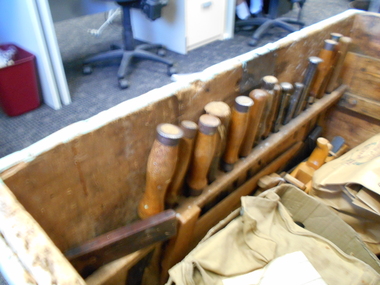
Pittock coach builder's box, 15 assorted chisels located in assigned locations at the front of the box: * 12 steel chisels with wooden handles in various stages of use, and 3 cold steel cold chisels * some chisels have manufacturer's marks, indistinguishable to read two chisels have P (Pittock) incised into the wooden handle * 4 straight chisels, 245-280 mm L, 10-23 mm cutting edges * 4 curved chisels, 245-320 mm L, 10-30 mm cutting edge * 2 cold chisels, 160-195 mm L * 1 steel punch, 165 mm L * 4 narrow bevelled eased chisels, 215-280 mm L, narrow cutting edges Items stored in Pittock coach builder's box, reference 13000.1. -
 Queen Victoria Women's Centre
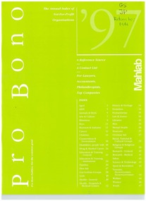
Newsletter, Mahlab Direct, Pro Bono Publico: For the common good, c. 1997
Pages 26 and 46 mention the QVWC. 48 pages. Green cover. White text. Black and white images throughout. In top right corner of cover writing in ink "GS JP Return to MM" philanthropists, book, charitable organisations -
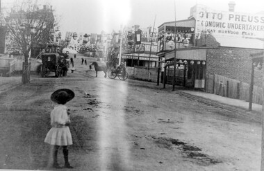 Surrey Hills Historical Society Collection
Photograph, Empire Day in Surrey Hills circa 1912
Empire Day celebrations were held from 1908-1912. Prior to the opening of the railway in 1893 the only public transport to Surrey Hills was the Melbourne-Lilydale horse coach which travelled to Surrey Hills down Victoria Street and Mont Albert Road. The fare to Union Road was 9 pence. Photo 16-4a was the number given to the original print provided by the State Savings Bank. Ken Hall made a negative from it, and the reprint of this was given the number 1459. This number was chosen as the catalogue number to avoid confusion with SHP4a. Photo provided by Surrey Hills branch of State Savings Bank of Victoria in 1978 for launch of Surrey Hills Neighbourhood Centre and was one of the first photos in the collection. The inscriptions on the reverse may indicate it was used in the Surrey Hills Neighbourhood News.Black and white photo of Union Road looking south towards Canterbury Road. The street is decorated with lanterns and the Union Jack and other flags for Empire Day celebrations. There is a young girl in the foreground looking towards the railway crossing where there is a horse drawn cab and a horse drawn cart. Business signage includes that for a butcher, Sneddon's Real Estate and Otto Preuss, Economic Undertaker.On rear: "113% "; "Enlarge to 172 mm" and 2 arrows, all in blue biro.union road, empire day celebrations, horse drawn vehicles, undertaker, sneddon real estate, businesses, union road shops, otto preuss -
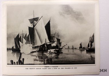 Flagstaff Hill Maritime Museum and Village
Greeting Card
Greeting card with black and white photograph of "FIRE A SALUTE". "THE TRINITY HOUSE YATCH AND A VIEW OF THE THAMES IN 1787". 183 mm x 139 mm SH 281 Ships T-Z.flagstaff hill, warrnambool, shipwrecked-coast, flagstaff-hill, flagstaff-hill-maritime-museum, maritime-museum, shipwreck-coast, flagstaff-hill-maritime-village, photograph, fire a salute -
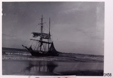 Flagstaff Hill Maritime Museum and Village
Photograph
Black and White photograph of sailing ship Wollamai breaking up on beach with reflections. Taken by W.H. Pengilley 144 mm x 105 mm SH 306.2 Ships T-Zflagstaff hill, warrnambool, shipwrecked-coast, flagstaff-hill, flagstaff-hill-maritime-museum, maritime-museum, shipwreck-coast, flagstaff-hill-maritime-village, photograph, wollamai, w.h. pengilley -
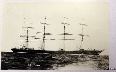 Flagstaff Hill Maritime Museum and Village
Photograph
Black And White photograph of the sailing ship Lancing, on reverse side it states Lancing Ex SS Periere 228 mm X 144 mm Sh 152.1 Ships I - L.flagstaff hill, warrnambool, shipwrecked-coast, flagstaff-hill, flagstaff-hill-maritime-museum, maritime-museum, shipwreck-coast, flagstaff-hill-maritime-village, photograph, lancing, ss periere -
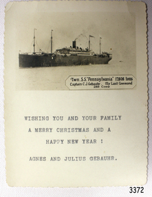 Flagstaff Hill Maritime Museum and Village
Greeting Card
Black And White Greeting Card of the TSS Pennsylvania, 17808 Tons. Captain C.J. Gebauhr. 285 crew. 109 mm X 140 mm Sh 234 Ships M - Rflagstaff hill, warrnambool, shipwrecked-coast, flagstaff-hill, flagstaff-hill-maritime-museum, maritime-museum, shipwreck-coast, flagstaff-hill-maritime-village, greeting card, tss pennsylvania, captain c.j. gebauhr -
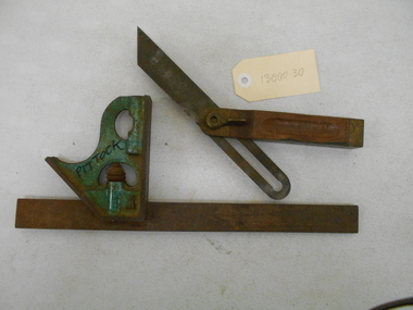 Bendigo Historical Society Inc.
Tool - PITTOCK COLLECTION: TWO SQUARES FOR SET OUT
Pittock collection: two metal carpenter's squares for set out * green painted adjustable set out square, with imperial and metric scales, and level bubble, 305 mm L x 120 mm W. Marked Pittock with marker * adjustable set out for full range of angle set out. steel wood and brass construction. Marked Stanley, patented 9-6-04. Tool 204-325 mm L x 25 mm W x 20 mm D Items stored in Pittock box coach builder's box, reference 13000.1. -
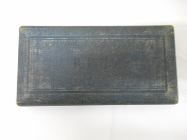 Bendigo Historical Society Inc.
Tool - PITTOCK COLLECTION : TWO DRAFTING INSTRUMENT SETS
Two drafting instrument sets: * smaller green boxed set with non-operating lock, noted R. Pittock on the face of the box; seven drafting components made of steel an bone; 165 mm L x 85 mm W x 20 mm D * red boxed drafting set, complete set, with A. G. Thornton maker's marking. British made, Limited Paragon Works, Practical manufacturers, King St West Manchester. Six component set, includes two compasses, also three drawing pins. Box 193 mm L x 85 mm W x 20 mm D. Items stored in Pittock coach builders box, reference 13000. -
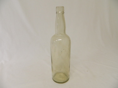 Kiewa Valley Historical Society
Bottle - Spirits, Late 1920's to early 1930's
Spirits came in bottles sold at licensed premises either locally or in larger cities visited during shopping expeditions. The shape of bottles varied and were re cycled remaining the property of the manufacturer who paid for their return.Historical: Change of bottles - shape, glass, embossing. Collected by bottle collectors. Aesthetic: Display showing embossing and the shape especially when in good condition.Clear glass bottle used for whisky. Straight sides 190 mm high then a sharp taper to the neck which bulges a little and is 100 mm high. It had a cork stopper. It is embossed on the base.Base: A.G.M. A 6bottle, spirits, whisky -
 4th/19th Prince of Wales's Light Horse Regiment Unit History Room
Badge, Life Member 4/19 Prince of Wales's Light Horse Regiment Association, abt 1990
27 mm dia milled edge disc on which is affixed Regt badge. Suspended from a 6 x 40 mm rectangular piece - with LIFE MEMBER in gold lettering on blue background.regimental association -
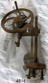 Flagstaff Hill Maritime Museum and Village
Drill Press
A hand cranked pedestal drill press, embossed "Union" and "IH276", wooden handle on the fly wheel, handle has copper wire wrapped around it, 845 mm high, 475 mm wideflagstaff hill, warrnambool, shipwrecked-coast, flagstaff-hill, flagstaff-hill-maritime-museum, maritime-museum, shipwreck-coast, flagstaff-hill-maritime-village -
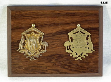 Bendigo Military Museum
Memorabilia - MEDALLON, PIANGIL FRIENDS WW1, 1919
John Thomas O'Bree MM, Regt No 6865. Refer Cat No 1334 for his service details and award of the “MM”.Wooden board with two medallions. Medallions are gold coloured with a shield supported by a kangaroo and emu underneath a boomerang. On the shield is an infantryman and underneath is an arrangement of leaves. The medallion on the right is flipped around to show the inscription on the back.On rear of right medal: "Presented to Lce Cpl O'Bree from his Piangil Friends for services in →France← 1919"numismatics-medals-commemorative, piangil, obree -
 Eltham District Historical Society Inc
Photograph - Aerial Photograph, Main Road, Eltham near Leanne Drive, 2 Jul. 1951
Not originally catalogued in Shire of Eltham Archives but from the same series of photos taken for Country Road Board study of Main Road wideningshire of eltham archives, aerial photo, country roads board, eltham, main road, road widening, leane drive, 1951-07 -
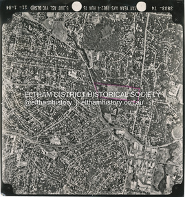
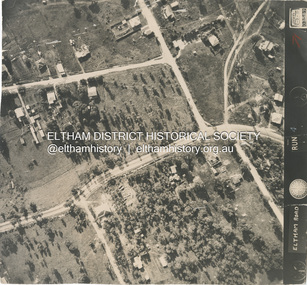 Eltham District Historical Society Inc
Photograph - Aerial Photograph, Main Road, intersection Grand Boulevard and Panorama Avenue, Lower Plenty / Montmorency, 2 Jul. 1951
Not originally catalogued in Shire of Eltham Archives but from the same series of photos taken for Country Road Board study of Main Road wideningshire of eltham archives, aerial photo, country roads board, eltham, main road, road widening, 1951-07, airlie road, ambulance station, beleura grove, grand boulevard, looker road, lower plenty, montmorency, panorama avenue -
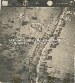
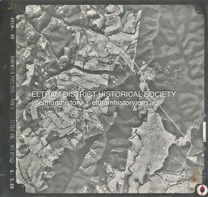
 Eltham District Historical Society Inc
Photograph - Aerial Photograph, Montmorency to Eltham North, 11 Jan. 1984
Area highlighted in purple is the future Nerreman Gateway Estate spanning from Ryans Road to Karingal Driveshire of eltham archives, aerial photo, eltham north, montmorency, nerreman gateway, nerreman park estate, ryans road, karingal drive -
 Eltham District Historical Society Inc
Photograph - Aerial Photograph, Smiths Gully, Christmas Hills, St Andrews, Kinglake National Park, 6 Mar. 1986
Small scale Red arrow indicates Northshire of eltham archives, aerial photo, christmas hills, kinglake national park, smiths gully, st andrews -
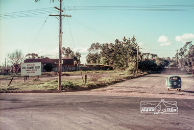
 Eltham District Historical Society Inc
Slide, Site for the new Apex-Diamond Valley Ambulance Station, corner of Main Road and Looker Road, Montmorency, July 1969, 1969
Looking northwest from Main Road towards Looker Road at the new site for the Apex-Diamond Valley Ambulance Station before construction of Apex Way, July 1969. The Eltham Apex Club conducted a Community Service Project (1965-1968) to raise funds for a new Ambulance Station to service the community. A site bounded by the intersection of Main Road, Grand Boulevard and Looker Road at Montmorency was purchased in 1969. In 1970, Eltham Shire Council undertook roadworks to construct Apex Way in preparation for the new station as well as duplicate Main Road, Lower Plenty, east of Grand Boulevard including the new Lower Plenty Bridge, which had been opened in November 1966, bordering with the City of Heidelberg.35 mm colour positive transparency Mount - Agfacolor Service (Blue)1969-07, ambulance station, apex way, apex-diamond valley ambulance station, eltham ambulance station, looker road, lower plenty, main road, montmorency, eltham apex club -
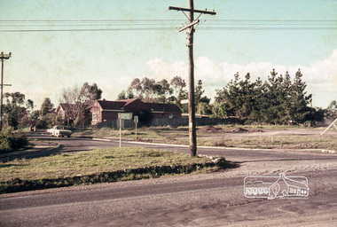
 Eltham District Historical Society Inc
Slide, Site for the new Apex-Diamond Valley Ambulance Station, corner of Main Road and Grand Boulevard, Montmorency, July 1969, 1969
View looking west along Grand Boulevard from the intersection with Main Road and Panorama Avenue, Montmorency showing the site for the new Apex-Diamond Valley Ambulance Station and before construction of Apex Way, July 1969. The Eltham Apex Club conducted a Community Service Project (1965-1968) to raise funds for a new Ambulance Station to service the community. A site bounded by the intersection of Main Road, Grand Boulevard and Looker Road at Montmorency was purchased in 1969. In 1970, Eltham Shire Council undertook roadworks to construct Apex Way in preparation for the new station as well as duplicate Main Road, Lower Plenty, east of Grand Boulevard including the new Lower Plenty Bridge, which had been opened in November 1966, bordering with the City of Heidelberg.35 mm colour positive transparency Mount - Agfacolor Service (Blue)1969-07, ambulance station, apex way, grand boulevard, lower plenty, main road, montmorency, eltham ambulance station, apex-diamond valley ambulance station, eltham apex club -
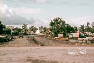 Eltham District Historical Society Inc
Slide, Reconstruction of Grand Boulevard viewed from Panorama Avenue, Montmorency, 18 August 1970, 1970
The Eltham Apex Club conducted a Community Service Project (1965-1968) to raise funds for a new Ambulance Station to service the community. A site bounded by the intersection of Main Road, Grand Boulevard and Looker Road at Montmorency was purchased in 1969. In 1970, Eltham Shire Council undertook roadworks to construct Apex Way in preparation for the new station as well as duplicate Main Road, Lower Plenty, east of Grand Boulevard including the new Lower Plenty Bridge, which had been opened in November 1966, bordering with the City of Heidelberg.35 mm colour positive transparency Mount - Agfacolor Service (Blue)1970-08-18, apex-diamond valley ambulance station, eltham ambulance station, eltham apex club, grand boulevard, montmorency