Showing 733 items matching " aerial photo"
-
 National Vietnam Veterans Museum (NVVM)
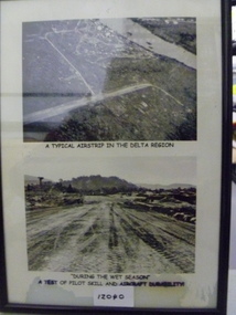
Photograph, A Typical Airstrip In The Delta Region
... is an aerial photo of an unknown airstrip in the Delta Region. Bottom... photo is an aerial photo of an unknown airstrip in the Delta ...Two black and white photograph in a frame - Top photo is an aerial photo of an unknown airstrip in the Delta Region. Bottom photo depicts tyre tracks on the muddy airstrip during the wet seasonTop photo - 'A Typical Airstrip In The Delta Region' Bottom photo - 'During the wet season a test of pilot skill and aircraft durabilityairstrip, wet season, photograph -
 Whitehorse Historical Society Inc.
Article, Lakeside fun, 1993
... . The Rotary Club donated a series of aerial photos of Nunawading going... a series of aerial photos of Nunawading going back 60 years which ...Nunawading Rotary Club's annual fun day at Blackburn Lake.Nunawading Rotary Club's annual fun day at Blackburn Lake. The Rotary Club donated a series of aerial photos of Nunawading going back 60 years which will be on show in the visitor's centre.Nunawading Rotary Club's annual fun day at Blackburn Lake.nunawading rotary club, blackburn lake, meagher, dorothy, tierney, peter, wittick, max, francis, john -
 Falls Creek Historical Society
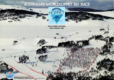
Poster - Kangaroo Hoppet 1992
... A large coloured poster featuring an aerial photo of cross... poster featuring an aerial photo of cross country skiers from ...The Kangaroo Hoppet is Australia’s premier long distance cross country ski race, and a member of the Worldloppet series of international cross country ski events. The first race at Falls Creek was held in 1979 under the name of “Australian Birkebeiner”. It was a 21km race with about 80 participants organised by the Birkebeiner Nordic Ski Club of Mount Beauty. The course started and finished at Falls Creek Alpine Resort and took participants out into the Bogong High Plains. After running the event for 10 years, it was decided they should become part of the Worldloppet series of marathon ski races. Representatives from the Birkebeiner Nordic Ski Club and the Australian Ski Federation attended the Worldloppet Annual Meeting in Finland in June 1990 to put the case for the acceptance of an Australian event into the Worldloppet series. Before being admitted, they had to demonstrate that the Birkebeiner Club could run a world class event, so three months later in August 1990 a 42km event named the Australian International Ski Marathon was held at Falls Creek together with a 21km Birkebeiner race and a 7km event called the Birkebeiner Lite. The event was approved by delegates from USA, Norway and Austria, in 1991 Australia became the 12th member of Worldloppet, with the condition that there had to be a name change. After some late night discussion allegedly involving red wine from North East Victoria the main event became the 42km Kangaroo Hoppet, with the minor events being the 21km Australian Birkebeiner, and 7km Joey Hoppet. In the winter of 1991, the first Kangaroo Hoppet was held. It was a great success and has been a regular fixture on the international ski calendar ever since. It features the main 42km event as well as a 21km event and a 7km event. The Hoppet brings the Australian snowfields to an international audience. In 1992 the Men's Winner was Gudmund Skjeldal from Norway in a time of 1:47:17. The winner of the Women's event was Beatrice Grunenfelder of Switzerland in a time of 2:12:49. This poster is significant because it documents an event which brings international attention to Falls Creek and the surrounding region.A large coloured poster featuring an aerial photo of cross country skiers from the 1991 event. The logo of the Kangaroo Hoppet is in the centre top position and the Worldloppet logo is in the bottom left corner.At top: AUSTRALIA' S WORLDLOPPET SKI RACE / FALLS CREEK VICTORIA / 29TH AUGUST 1992 Beside Worldloppet logo: Details from Race Secretary Box 192 Mt. Beauty 3699 Australia Photo: Ken Bell, PhotoMotionkangaroo hoppet, worldloppet events, falls creek, mt. beauty -
 Bendigo Military Museum
Administrative record - Australian - United Kingdom Exchange End of Tour Report by WO2 KA Fenton RE 1990, WO2 KA Fenton RE, 25.10.1990
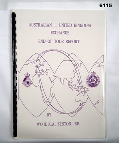
... foe RASvy and Royal Engineers (UK), back cover overhead aerial... and Royal Engineers (UK), back cover overhead aerial Photo of Army ...A 2 x year personnel exchange program existed between RASvy and the Survey elements of the Royal Engineers UK. This is an end of Tour Report produced by WO2 KA Fenton RE of his experiences during his exchange tour. An A4 Booklet stylised map of the world with Corps Badges foe RASvy and Royal Engineers (UK), back cover overhead aerial Photo of Army Svy Regt, 14 Pages, 4 Annexes and an enclosureroyal australian survey corps, rasvy, fortuna, army survey regiment, army svy regt, asr -
Port Melbourne Historical & Preservation Society
Photograph - Aerial view of Station Pier, Port Melbourne on completion, Port Melbourne, 1930
... Aerial photo of Station Pier on completion, 1930. Three... - collier ps weeroona ps hygeia Transport - Ferries Aerial photo ...Aerial photo of Station Pier on completion, 1930. Three colliers 'laid up' on east side and Weeroona (east) and Hygeia (west) laying at the wing piers. Shows the area set aside for Centenary Bridge.centenary bridge, melbourne harbor trust - port of melbourne authority, piers and wharves - station pier, transport - shipping, engineering - bridges, dumosa - collier, werribee - collier, ashridge - collier, ps weeroona, ps hygeia, transport - ferries -
Port Melbourne Historical & Preservation Society
Photograph - Aerial view of HMS Repulse being berthed at outer west Princes Pier by tug James Patterson, Port Melbourne, Royal Australian Air Force (RAAF), 1924
... Air Force aerial photos of the visit of HMS Hood and HMS... hms hood hms repulse ss james patterson Air Force aerial ...Air Force aerial photos of the visit of HMS Hood and HMS Repulse 1924 04 - HMS Repulse being berthed at Outer West Princes Pier by tug James Patterson. New beacons are visiblepiers and wharves - princes pier, transport - shipping, armed services - navy, hms hood, hms repulse, ss james patterson -
 Port Melbourne Historical & Preservation Society
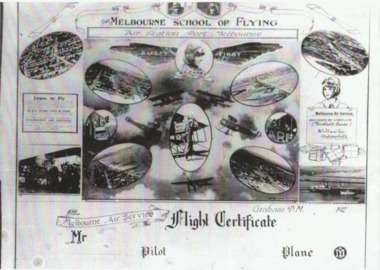
Photograph - Flight certificate given to passengers on Carey planes, 1920s
... (.01) lasercopy of aerial photo of Carey's Melbourne Air...) lasercopy of aerial photo of Carey's Melbourne Air Service aerodrome ...Sent by Carey's daughter Bertha Harvey during compilation of transport book "Linking "Us Together. (.01) lasercopy of aerial photo of Carey's Melbourne Air Service aerodrome on the Bend (Item .01 is absent from file as at Dec 2013) (.02) lasercopy of the Flight Certificate given to passengers on Carey planesfishermans bend, transport - aviation and aerodrome, r graham carey, melbourne air service -
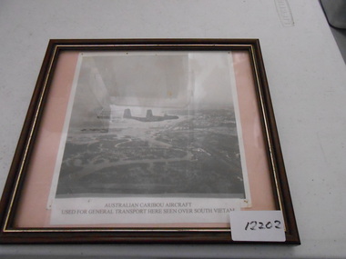 National Vietnam Veterans Museum (NVVM)
Photograph, Two RAAF Caribou over Vietnam
... A black and white aerial photo of two Australian Caribou's...A black and white aerial photo of two Australian Caribou's ...A black and white aerial photo of two Australian Caribou's aircrafts. The aircrafts were used in Vietnam for the transportation of soldiers to and from the conflict and was used for general transport of equipment. Photograph of two RAAF Caribou Aircraft over Vietnamcaribou, photograph, south vietnam -
Port Melbourne Historical & Preservation Society
Photograph - Aerial view of J Kitchen & Sons site, Port Melbourne, 1945
... Large black and white aerial photo in narrow gold-coloured... aerial photo in narrow gold-coloured metal frame of J Kitchen ...Large black and white aerial photo in narrow gold-coloured metal frame of J Kitchen & Sons Pty Ltd factory in foreground and Dunlop Tyres building in the background. Photo taken approx 1945 (copy)industry - manufacturing, built environment - industrial, j kitchen & sons pty ltd, pental products pty ltd, symex holdings ltd -
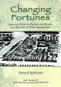 Port Melbourne Historical & Preservation Society
Book, David Radcliffe, Changing Fortunes, March 2021
... Melbourne" Soft cover book. Green in colour with images of aerial... with images of aerial photo of port Melbourne on front and back covers ..."Ebb and flow of people and places in a pocket of Port Melbourne " Also contains many references throughout the book to PMHPS collectionWhat it was like to live around the upper reaches of the former Sandridge Lagoon from pre settlement times up until the 1940s. It locates the history of many families who built their dreams on a pocket of reclaimed land in Port Melbourne in the 1880s "Ebb and flow of people and places in a pocket of Port Melbourne" Soft cover book. Green in colour with images of aerial photo of port Melbourne on front and back covers. On back page "once as it was - Boon Wurrong Foundation" yalukit willam, boon-warrung, george beazley, anne chaffey, swallow & ariell ltd, port melbourne town hall, sandridge lagoon, business and traders - milkbars, spring street, esplanade east, built environment - commercial, built environment - domestic, domestic life -
 Greensborough Historical Society
Book, Typical Homes that would be constructed by Mitchell Trading Pty Ltd, 1960_
... cover. Contains 14 photos of houses and shops and 14 aerial... of houses and shops and 14 aerial photos of Bundoora including ...An early advertising brochure for prospective homeowners to choose the style of home they would like built. House and land packages were available in the areas of Bundoora surrounding the Loyola and Parade College sites, which were monasteries in the 1960s. The aerial photographs show the open nature of the landscape from Bundoora across to Greensborough and Watsonia in the 1960s. Book of black and white photographs bound in brown card cover. Contains 14 photos of houses and shops and 14 aerial photos of Bundoora including the Loyola and Parade College areas. Includes notes from Gary Partington.In pencil inside front cover: 29/1/1960.houses, bundoora, greensborough, watsonia, loyola college, parade college, mitchell trading, aerial photography -
Glenelg Shire Council Cultural Collection
Programme - Souvenir Program - 1981 Portland, Victoria, c. 1981
... of RACV) on front cover; aerial photo of the harbour (photo... of the Hentys' (Photo courtesy of RACV) on front cover; aerial photo ...1981 Portland 'Back-to' Souvenir Program. Glossy card covers, coloured image 'landing of the Hentys' (Photo courtesy of RACV) on front cover; aerial photo of the harbour (photo courtesy of Portland Harbour Trust) on back cover -
Glenelg Shire Council Cultural Collection
Photograph - Photograph - Main Breakwater construction, Portland, n.d
... Black and white aerial photo of the harbour, showing early... stamp- '14 Feb 1958' Black and white aerial photo of the harbour ...Port of Portland Authority ArchivesFront: Purplestamp- '14 Feb 1958" Back: Purple stamp- '14 Feb 1958'port of portland archives, harbour construction, main breakwater -
Glenelg Shire Council Cultural Collection
Photograph - Photograph - Main Breakwater construction, Portland, n.d
... Black and white aerial photo of the harbour, showing early...'- Pink texta Back: 'c' - Pink texta Black and white aerial photo ...Port of Portland Authority ArchivesFront: 'c'- Pink texta Back: 'c' - Pink textaport of portland archives, harbour construction, main breakwater, fishermans breakwater, ocean pier -
Glenelg Shire Council Cultural Collection
Photograph - Photograph - Main Breakwater construction, Portland, n.d
... Black and white aerial photo of the harbour, showing early...: Purplestamp- '14 Jan 1958' Black and white aerial photo of the harbour ...Port of Portland Authority ArchivesFront: Purple stamp- '14 Jan 1958' Back: Purplestamp- '14 Jan 1958'port of portland archives, aerial photography, portland harbour -
 Phillip Island and District Historical Society Inc.
Photograph, Historic aerial photographs of Phillip Island, Cowes, Rhyll, Cape Woolamai and San Remo, 1930s
... A C D Rom and USB of historic aerial photos about 1930s... of historic aerial photos about 1930s - 1940s of Phillip Island, Cowes ...Photos taken by an unknown pioneer aviator researched by Kevin O'Reilly who has written a book "Flyers of Time" on pioneer aviation. Photos show the Island and San Remo prior to development and before the bridge was built from the mainland.HistoricalA C D Rom and USB of historic aerial photos about 1930s - 1940s of Phillip Island, Cowes, Rhyll, San Remo and Woolamai. Both formats contain the same 7 photos. Also a letter explaining the history of the photos.photographs, san remo, rhyll, cape woolamai, phillip island bridge, cowes, aerial photograph, digital media, residential development, newhaven -
 Kiewa Valley Historical Society
Maps 3D - National Parks
... Black and white large aerial photos of the Bogong High... Black and white large aerial photos of the Bogong High Plains ...Used by the employees of National Parks. The maps show the topography and contours in 3D when used with the stereoscope KVHS 0743. This enables the photographed area to be compared to previous photos and enables the planning of construction of eg. new roads etc. Digital information is now available.These photographs give the topography and contours of vast local areas eg. Mt Feathertop and Tawonga township.when used with a stereoscope. Black and white large aerial photos of the Bogong High Plains area. 14 to 20 of them all on thick paper and the same size as the brown wooden box which holds them. The box hasn't got a lid at the top.Identified and catalogued by National Parksmaps showing topography, national parks, stereoscope -
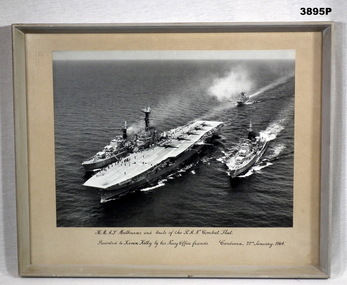 Bendigo Military Museum
Photograph - PHOTOGRAPH RAN, FRAMED, Pre 1964
... Black / white aerial photo of HMAS Melbourne with 5...: “(Kevin Kelly)” Black / white aerial photo of HMAS Melbourne ...Black / white aerial photo of HMAS Melbourne with 5 aircraft on the flight deck plus 4 units of the RAN Combat fleet at sea. Photo is mounted with a fawn border with a grey wooden frame, glass front & fawn paper backing.Printed underneath photo in black ink: “H.M.A.S Melbourne and Units of the R.A.N. Combat Fleet” “Presented to Kevin Kelly by his Navy Office friends. Canberra 22nd January 1964” Written on back in pencil : “(Fate of Voyager and Melbourne) H.M.A.S. Voyager collided with H.M.A.S. Melbourne Feb 1964 - 81 lives lost” Written on back In black texta: “(Kevin Kelly)”photographs, hmas, melbourne -
Port Melbourne Historical & Preservation Society
Photograph - Aerial view of (finally) in-filled Lagoon, Port Melbourne, 1931
... Aerial photo of Port Melbourne c1931 showing clearly... Aerial photo of Port Melbourne c1931 showing clearly the finally ...Image seems to be one of several aerial shots around 1931, possibly all shot from one flight. Aerial photo of Port Melbourne c1931 showing clearly the finally filled Lagoon, and central area from Gasworks to past Bay Street, from Town Hall to Town Pier. Cable tram cars can be seen on Bay Streetsandridge lagoon, built environment -
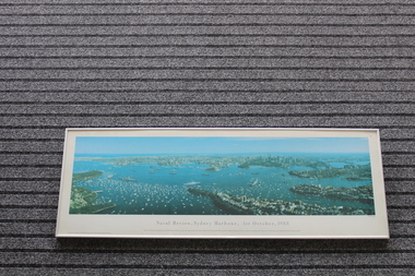 Lara RSL Sub Branch
Framed Print of Naval Review,Sydney Harbour, 1st October,1988, Naval Review,Sydney Harbour, 1st October,1988, 12/01/1990
... convict ships at Sydney in 1788. This aerial photo shows naval... in 1788. This aerial photo shows naval and pleasure craft ...The bicentenary of Australia was celebrated in 1988. It marked 200 years since the arrival of the First Fleet of British convict ships at Sydney in 1788. This aerial photo shows naval and pleasure craft in Sydney Harbour for the bicentennial celebrations.The bicentennial year marked Captain Arthur Phillip's arrival with the 11 ships of the First Fleet in Sydney Harbour in 1788, and the founding of the city of Sydney and the colony of New South Wales. 1988 is considered the official bicentenary year of the founding of Australia. Rectangular shaped glass covered picture frame showing photo of Naval Review, Sydney Harbour, 1st October,1988Naval Review, Sydney Harbour, 1st October,1988 This 140 degree panoramic photograph was taken from a helicopter by Phil Gray. It shows the visiting warships in the harbour including the USS New Jersey, FNS Colbert and HMS Ark Royal in the foreground.This print is the fourth in the Sydney Harbour Panorama series by Phil Gray who uses Kodak film.Printed in Australia.prints, naval photos, hms ships, sydney harbour, lara r.s.l. -
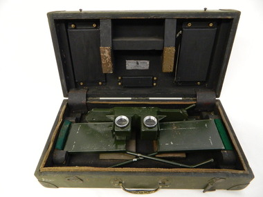 Kiewa Valley Historical Society
Stereoscope
... to interpret aerial photography and the landscape. It was used... located at Mt Beauty to look at aerial photos so that they showed ...The stereoscope was an interpretation device used to interpret aerial photography and the landscape. It was used by National Parks Victoria located at Mt Beauty to look at aerial photos so that they showed up the relief of the topography and therefore looked 3D.Used by National Parks Victoria staff located at the Mt Beauty office during the 1970's and early 1980's.Dark green wooden box with padded protection around the perimeter and on lid where 2 rectangular pieces of wood touch the stereoscope. The box is fitted with wooden dividers that fit around the stereoscope. The stereoscope is green metal with folding legs and sides attached to allow the stereoscope to sit on a surface. The instrument has 2 round glass ('mirrored viewing lens') cylinders eye distance apart, that allow light in from the side swinging doors. The amount of light is constricted by a rectangular piece of metal at the top of each leg. The box has swing clips used to close it and a metal swing handle all on the front side.The hinges are reinforced (and offer protection) by additional rubber pieces at each end. Inside the box is a brush made of bristle with a wooden handle - used for cleaning.Outside and top of box: written in black: No. 1026. On blue tape beneath: Mirror stereoscope 1026. written in black centre top of box: W10/WKA.0233. On front edge of box written in black: W10/WKA 0233. Inside box lid on silver plaque: Stereoscope Universal/ Made in / Australia / Die Casters Ltd. Victorianational parks victoria. stereoscope. aerial photographs. scientific instrument. mt beauty. 3d -
Tatura Irrigation & Wartime Camps Museum
Book, Girgarre Living History, Girgarre. Girgarre Living History, 2016
... Rectangular shaped book ,aerial photo of the township... settlement Rectangular shaped book ,aerial photo of the township ...Girgarre - an extraordinary history, closer settlement, soldier settlement and family stories.Tells of the history of Girgarre, with information obtained from a collection of stories and extensive research into the Closer and Soldier Settlement of the districtRectangular shaped book ,aerial photo of the township and environs of Girgarre, on Market Day, September 2013. Photo extends over front & back covers, highly colourful cover. 251 pages. B/W photos and maps of local families and local scenes.girgarre, family histories, soldier settlement -
Tatura Irrigation & Wartime Camps Museum
Book, Girgarre Living History, Girgarre. Girgarre Living History, 2016
... Rectangular shaped book ,aerial photo of the township... shaped book ,aerial photo of the township and environs ...Girgarre - an extraordinary history, closer settlement, soldier settlement and family stories.Tells of the history of Girgarre, with information obtained from a collection of stories and extensive research into the Closer and Soldier Settlement of the districtRectangular shaped book ,aerial photo of the township and environs of Girgarre,on Market Day, September 2013. Photo extends over front & back covers, highly colourful cover. 251 pages ,B/W photos and maps of local families and local scenes.girgarre, family histories -
Port Melbourne Historical & Preservation Society
Photograph - Photocopy, Aerial view over Swallow & Ariell and surrounds, 1950
... Large photocopy of an aerial photo. 1950 view over Swallow... photocopy of an aerial photo. 1950 view over Swallow & Ariell ...Donor was researching property on the corner of Stokes and Graham St, as old timers claim it was "the Nelson Hotel" although there is no record of such in licensing records. Particular building is at upper left of this image.Large photocopy of an aerial photo. 1950 view over Swallow & Ariell and the Counting House shows St Joseph's Catholic Church; Methodist Church on Graham St (no longer there); Nott Street factories. The "Nelson Hotel" partially showing in the upper left corner.built environment - industrial, industry - food, swallow & ariell ltd, religion - anglican (holy trinity), religion - wesleyan methodist church, religion - roman catholic church (st josephs), nelson hotel, frederick thomas derham, built environment - domestic, business and traders - hotels -
 Vision Australia
Photograph - Image, Aerial view of the Royal Victorian Institute for the Blind grounds in St Kilda Road, 1927
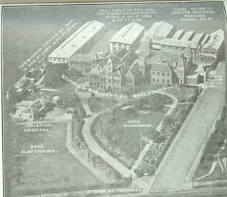
... Aerial photo of the RVIB St Kilda Road buildings... Aerial photo of the RVIB St Kilda Road buildings and grounds ...Aerial photo of the RVIB St Kilda Road buildings and grounds, scanned from an unknown printed source. On the image are written descriptions of buildings, including the width and length of those erected in 1920's, the isolation hospital and the segregation of boys and girls playing areas. 1 scanned image of RVIB St Kilda Road from airGirls playground School & residential buildings Boys playground Isolation hospital This building, erected in 1926 - is 200 ft long & 40 ft wide Each floor of this new two storied building erected in 1926 is 100 ft long & 40 ft wide These recently erected factories measure 20,000 sq ft Ormond Hall for socials, etc. St Kilda Road frontageroyal victorian institute for the blind, buildings -
 Melbourne Tram Museum
Newspaper, The Age, "Tram depot site in Southbank up for sale", 16/07/1997 12:00:00 AM
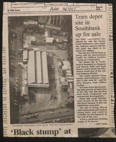
... an aerial photo. Quotes John Marasco of Colliers. Written by John... of the site and has an aerial photo. Quotes John Marasco of Colliers ...Newspaper clipping, The Age 16/7/1997, titled "Tram depot site in Southbank up for sale", advising the depot site would be sold by Colliers Jardine. Gives details of the site and has an aerial photo. Quotes John Marasco of Colliers. Written by John Hurley.trams, tramways, sale of land, south melbourne depot, southbank depot, tram depot -
Glenelg Shire Council Cultural Collection
Pamphlet - BROCHURE, Portland Aluminium Smelter, n.d
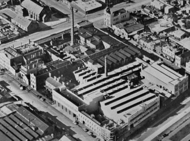
... ' on front, above aerial photo of smelter. Back has diagram...' on front, above aerial photo of smelter. Back has diagram ...Two tri-fold brochures produced by Portland Aluminium. Contains history, economic importance, and manufacturing information. Black and white. Blue 'PORTLAND ALUMINIUM SMELTER' on front, above aerial photo of smelter. Back has diagram of smelter, area marked with blue numbers to match legend.portland aluminium smelter -
Port Melbourne Historical & Preservation Society
Photograph - Aerial view of Port Melbourne, circa 1928
... Aerial photo of Port Melbourne c1928 focusing on the Gas... Joshua Brothers Distillery Harpers Starch Factory Aerial photo ...Aerial photo of Port Melbourne c1928 focusing on the Gas Works area spanning Port Melbourne and Albert Park. Shows the finally filled Lagoon, and area from the Harpers Starch factory to Foote St, Albert Park and from the bay to just over Richardson/Liardet Stssandridge lagoon, built environment - industrial, industry, gasworks, joshua brothers distillery, harpers starch factory -
 Port Melbourne Historical & Preservation Society
Photograph - Aerial view of Swallow and Ariell factory, Port Melbourne, c. 1950
... . Both buildings are now converted to apartments. .03 - Aerial... building visible on right hand side of photo Photograph Aerial view ...The Sandridge Marine Lodge was founded in 1858. Two locations; originally Stokes St and then in Liardet St from 1917. Both buildings are now converted to apartments. .03 - Aerial photo of Swallow and Ariell factory, with Stokes St Lodge building visible on right hand side of photobuilt environment - civic, built environment - domestic, societies clubs unions and other organisations, built environment - industrial, freemasons lodge, swallow & ariell ltd, sandridge marine lodge -
Clunes Museum
Photograph
... Aerial coloured photo of Clunes, main buildings named...Aerial Clunes Mines John Woodland Collection Aerial ...Aerial coloured photo of Clunes, main buildings named and marked with yellow stickers, mines marked with white stickersaerial, clunes mines, john woodland collection