Showing 1534 items
matching aerial photographs
-
 Phillip Island and District Historical Society Inc.
Photograph, c. 1959
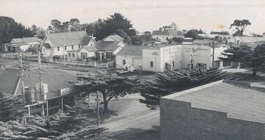
... Aerial photograph of the intersection of Thompson Avenue... West Aerial photograph of the intersection of Thompson Avenue ...One of a collection of over 400 photographs in an album commenced in 1960 and presented to the Phillip Island & Westernport Historical Society by the Shire of Phillip IslandAerial photograph of the intersection of Thompson Avenue & Chapel Street showing General Store, Phillip Island Garage and Catholic Church.local history, photography, intersection thompson avenue & chapel street, cowes, black & white photograph, thompson avenue cowes, chapel street cowes, garages, churches, john jenner, bryant west -
 Glenelg Shire Council Cultural Collection
Photograph - Photograph - aerial photo of Portland, n.d
... Photograph - aerial photo of Portland...Black and white aerial photograph of part of Portland... Black and white aerial photograph of part of Portland, Bentinck ...Port of Portland AuthorityBack: fdou3 - pencilport of portland archives, aerial photography, bentinck street, portland railway station, ocean pier -
Tatura Irrigation & Wartime Camps Museum
Book, Hill Top Golf & Country Club, 1985
... Soft cover - pale green with black and white aerial.... 26.6.85 Soft cover - pale green with black and white aerial ...History of formation of Hill Top Golf and Country Club and Bowls ClubSoft cover - pale green with black and white aerial photograph of Hill Top across middle and Hill Top logo.Presented to Tatura and District by J Forster. 26.6.85hill top golf and country club, hill top bowls club -
 Kew Historical Society Inc
Photograph - Aerial View of East Kew, c.1930
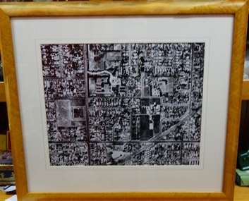
... Framed aerial photograph of that part of Kew in which... aerial photograph of Kew genazzano fcj kew reservoir rimington's ...The Municipality of Kew was proclaimed in 1860. This eastern section of Kew was settled from the 1850s with all land sold in the vicinity by 1851. The original large estates were further subdivided in the second half of the 19th and in the first decades of the 20th centuries.Early aerial photograph of KewFramed aerial photograph of that part of Kew in which is located Genazzano FCJ, the Kew Reservoir, and the retail nurseries of Bennett’s and Rimington's.genazzano fcj, kew reservoir, rimington's nurseries, bennett's nursery, cotham road, mont victor road (kew) -
 Bendigo Military Museum
Photograph - 4th Field Survey Squadron – Operation NERVOSE 85 Field Phase Oblique Photos, NT, 1985
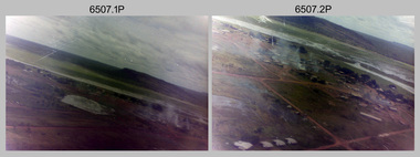
... This is a set of 20 oblique aerial photographs taken during...This is a set of 20 oblique aerial photographs taken during...This is a set of 20 oblique aerial photographs taken during ...This is a set of 20 oblique aerial photographs taken during the field phase of 4th Field Survey Squadron’s Operation NERVOSE 85 project in the Northern Territory in 1985. Operation NERVOSE 85 was mounted by 4 Fd Svy Sqn in the EAST ARNHEM, VICTORIA RIVER DOWNS AND DALY WATERS areas of the Northern Territory from 26 May to 18 Sep 85. The aim of Operation NERVOSE 85 was to finalise the horizontal and vertical control for mapping at a scale of 1:50,000, to field check 40x 1:50,000 preliminary maps and to obtain mapping photography in support of the RAAF TINDAL redevelopment project. *Note –These photos were most likely taken in 1985, contrary to the ‘1987’ date annotated on the negative sleeves. The Op NERVOSE 85 Project Report available on RASVY’s web site lists a nominal roll of personnel. Photos of 4 Fd Svy Sqn taken in 1985 and 1987 provide names of posted personnel. Several personnel identified in these photos were posted to 4 Fd Svy Sqn in 1985, not in 1987. See items 6504.13P, 6505.28P and 6506.16P for more photos taken prior to and during Operation NERVOSE 1985. This is a set of 20 oblique aerial photographs taken during the field phase of 4th Field Survey Squadron’s Operation NERVOSE 85 project in the Northern Territory in 1985. The colour photographs on 35mm negative film and are part of the Army Survey Regiment’s Collection. The photographs were scanned at 96 dpi. .1) to .20) - Photo, colour, 1985. Unknown locations..1P to .20P – There are no personnel identified. ‘1987 OP NERVOSE VICTORIA RIVER DOWNS AND DALY WATERS.’ annotated on negative sleeve.royal australian survey corps, rasvy, 4 fd svy sqn, op nervose 85 -
 Phillip Island and District Historical Society Inc.
Photograph, 1960
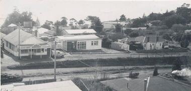
... Aerial photograph of the Cowes Kindergarten in Chapel... Aerial photograph of the Cowes Kindergarten in Chapel Street ...One of a collection of over 400 photographs in an album commenced in 1960 and presented to the Phillip Island & Westernport Historical Society by the Shire of Phillip IslandAerial photograph of the Cowes Kindergarten in Chapel Street, Cowes. Now next to the Cowes State School in Settlement Road. (JG 2017)local history, photography, cowes kindergarten, black & white photograph, kindergartens, chapel street cowes, john jenner, bryant west -
Glenelg Shire Council Cultural Collection
Photograph - Photograph - Portland Harbour, 1958
... Black & white aerial photograph of Portland Harbour, also... aerial photograph of Portland Harbour, also showing foreshore ...Port of Portland Authority ArchivesBack: "L - R" - top left pencil. Purple Stamp - TOP RIGHT "17 Nov 1958"port of portland archives, portland harbour, bentinck street, all saints, foreshore, 1958 -
Glenelg Shire Council Cultural Collection
Photograph - Photograph -K.S Anderson Wharf, n.d
... Black and white aerial photograph showing a sheep ship... and white aerial photograph showing a sheep ship berthed at the K.S ...Port of Portland Authorityport of portland archives, k s anderson wharf -
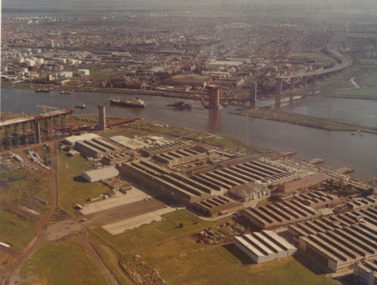 Port Melbourne Historical & Preservation Society
Photograph - Aerial view of West Gate Bridge under construction, 1960 - 1979
... Colour aerial photograph of West Gate Bridge under... on top right corner and on back Colour aerial photograph of West ...Colour aerial photograph of West Gate Bridge under construction. Fishermans Bend factories in foreground. Ship in the river and view to Williamstown"Master copy. Not to be removed from marketing Department" stamped on top right corner and on backtransport, engineering, engineering - bridges, fishermans bend, industry, west gate bridge, rotten row, williamstown, yarra river -
Port Melbourne Historical & Preservation Society
Photograph - Aerial view of Port Melbourne, 1931
... Section of aerial photograph of Port Melbourne c1931 (refer... Sandridge Lagoon Built Environment Section of aerial photograph ...Section of aerial photograph of Port Melbourne c1931 (refer item 574), covering Beach to Spring Street and Lagoon to Lyons Streetsandridge lagoon, built environment -
National Vietnam Veterans Museum (NVVM)
Document, The First Australian Field Hospital
... Framed Document featuring an Aerial Photograph... an Aerial Photograph of the hospital compound with buildings ...Framed Document featuring an Aerial Photograph of the hospital compound with buildings. Identified photograph is surrounded by the history of the hospitals, admission and service statistics.Variousframed document, first australian field hospital, vung tau -
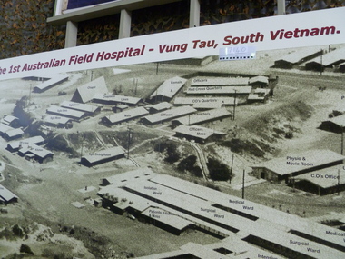 National Vietnam Veterans Museum (NVVM)
Photograph, 1 Aust FD Hospital Vung Tau South Vietnam
... Aerial photograph wall panel of 1 Aust Field Hospital Vung... Hospital 1 Australian Field Hospital Vung Tau South Vietnam Aerial ...Aerial photograph wall panel of 1 Aust Field Hospital Vung Tau, features layout and labelled building of hospital complex1 Australian Field Hospital Vung Tau South Vietnam1st australian field hospital -
Clunes Museum
Photograph, EXTENT OF MINE WORKINGS AT CLUNES, 1987
... AERIAL PHOTOGRAPH...AERIAL PHOTOGRAPH CLUNES GOLD WORKINGS MAP SUPERIMPOSED... WORKINGS IN CLUNES PORT PHILLIP MINE AERIAL PHOTOGRAPH QUARTZ ...MINE WORKINGS IN CLUNESAERIAL PHOTOGRAPH CLUNES GOLD WORKINGS MAP SUPERIMPOSED. MOUNTED ON CARDBOARD WITH DETAILS OF MINE LOCATION. TYPED DESCRIPTION PASTED BELOW.port phillip mine, aerial photograph, quartz mining -
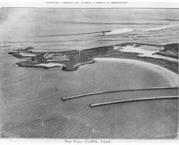 Port Fairy Historical Society Museum and Archives
Photograph, C. 1925
... Black and white aerial photograph of Griffith island... Fairyb Harbour 1925" Black and white aerial photograph ...Black and white arial photograph of the Moyne river entrance, the original signed by R.W.Golding.Black and white aerial photograph of Griffith island showing the lighthouse keeper’s compound, the large flagstaff and the river training walls in the foregroundHand written on the back "Port Fairy Moyne River Entrance R. W. Golding Handwritten on the back of the copy "Port Fairyb Harbour 1925"local history, photography, photographs, slides, film, arial, moyne river -
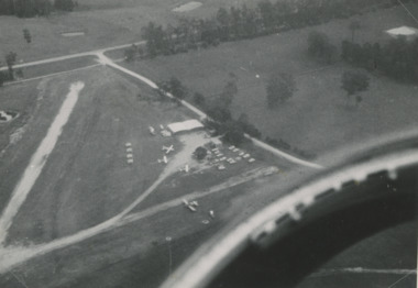 Lakes Entrance Historical Society
Photograph - Lakes Entrance, Lakes Post Newspaper, 1/01/1993 12:00:00 AM
... Aerial Photograph...Black and white aerial photograph of Campbell's Airfield... training at Campbell's Airfield Aerial Photograph Township Black ...DCNR Crews from Bairnsdale Swifts Creek and Nowa Nowa training at Campbell's AirfieldBlack and white aerial photograph of Campbell's Airfield Colquhoun Road showing planes and vehicles near hanger Lakes Entrance Victoriaaerial photograph, township -
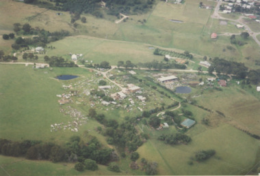
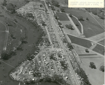 Bendigo Historical Society Inc.
Photograph - ELMORE FIELD DAYS 1969
... Aerial photograph of Elmore Field Days 1969. Photo...EVENT Agriculture elmore field days 1969 Aerial photograph ...Aerial photograph of Elmore Field Days 1969. Photo is attached to heavy card backing. Image shows Field Days site with exhibitor stands. Lines of parked vehicles along roadside. Adjacent to the site is an anabranch of the Campaspe River. A sticker on top of photo states ' Oblique Aerial photograph of Elmore Field Days - 1969'event, agriculture, elmore field days, 1969 -
 Greensborough Historical Society
Aerial Photograph, Banyule Road / Lower Plenty Road, 1972c
... Aerial Photograph...Aerial survey photograph, black and white... Aerial survey photograph, black and white Banyule Road / Lower ...Viewbank, Rosanna and Lower Plenty area, showing Lower Plenty Road and Banyule RoadAerial survey photograph, black and whiteviewbank -
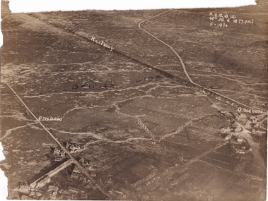 The Beechworth Burke Museum
Photograph, c1914
... Aerial photograph of a battle field in France during World...-country Aerial photograph of a battle field in France during World ...Aerial photograph of a battle field in France during World War OneBlack and white rectangular photograph printed on photographic paperObverse: Railway / British Line (in pen) / Reverse: Villers Brut /military album, burke museum, beechworth, beechworth museum, world war one, wwi, trenches, aerial photo, aerial photo trenches -
 The Beechworth Burke Museum
Photograph, c1914
... Aerial photograph of a battle field in France during World...-country Aerial photograph of a battle field in France during World ...Aerial photograph of a battle field in France during World War OneBlack and white rectangular photograph printed on photographic paperReverse: 6534 / Australian Official Photographs, No. E1253 /military album, burke museum, beechworth, beechworth museum, world war war, wwi, trenches, aerial photo, battlefield -
 Eltham District Historical Society Inc
Photograph - Aerial Photograph, Intersection of Main Road and Bridge Street, c.1995
... Aerial Photograph...Digital scan detail section of much larger aerial... scan detail section of much larger aerial photograph ...View of Main Road from Henry Street to Brougham Street across to the Diamond Creek showing the Eltham Shire Offices (demolished 1996), the Eltham Library (opened 1994)aerial photo, alistair knox park, bridge street, brougham street, central park, diamond creek (creek), eltham, eltham community centre, eltham courthouse, eltham justice precinct, eltham living and learning, franklin street, henry street, local history centre, main road -
Glenelg Shire Council Cultural Collection
Photograph - Photograph - aerial view of Portland, n.d
... Photograph - aerial view of Portland...Black & white aerial photograph showing Portland harbour... & white aerial photograph showing Portland harbour, aquatic centre ...Port of Portland Authority ArchivesBack: Harbour - pencilport of portland archives, aerial photography, portland harbour, henty park, canal -
Port Melbourne Historical & Preservation Society
Photograph - Aerial view of Port Melbourne, 1931
... Section of aerial photograph of Port Melbourne c1931 (refer... Sandridge Lagoon Built Environment Section of aerial photograph ...Section of aerial photograph of Port Melbourne c1931 (refer item 574), covering Beach almost to Bridge Street and Lagoon to Bay Streetsandridge lagoon, built environment -
Port Melbourne Historical & Preservation Society
Photograph - SS Nairana, C.1951
... B & W aerial photograph of SS Nairana and Port Melbourne... was blown up in 1954. SS NAIRANA Transport - Shipping B & W aerial ...The SS Nairana was launched 1915 by William Denny & Brothers in Dumbarton Scotland the 3,402 ton steamer was requisitioned by the Royal Navy and served during WW1. In 1922 she was transferred to Tasmanian Steamers and, apart from again being requisitioned for war service in WW2, was used as a Bass Strait ferry until 1948. The Nairana was blown ashore onto Port Melbourne beach during a severe gale on 19 February 1951. After salvage what remained of the wreck was blown up in 1954. B & W aerial photograph of SS Nairana and Port Melbourne foreshore. Ship's outline can be seen on far right side of photograp.ss nairana, transport - shipping -
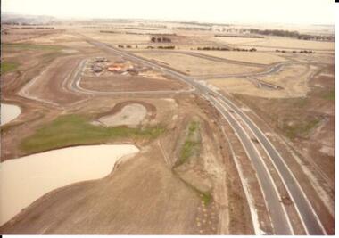 Hume City Civic Collection
Photograph, c 1978
... A coloured aerial photograph of a display village area... bella homes george evans collection A coloured aerial photograph ...On 4th August 1978 the construction of the Goonawarra Estate commenced. The estate was formerly known as the Goonawarra Farm and overlooked the Sunbury Township and the Jacksons Creek Valley. Plans for the development included a golf course, houses and community and recreational facilities. The golf course opened in 1980 and the housing construction continued throughout the last two decades of the twentieth century and into the twenty first century.A coloured aerial photograph of a display village area under construction. Two lakes are on the LHS of the photograph and Francis Boulevard is in the foreground and the middle distance.goonawarra golf club, goonawarra farm, goonawarra housing estate, housing developments, sharkey, robert b., kilkenny homes, australian ideas homes pty.ltd., glamor homes, craftsmen homes., villa bella homes, george evans collection -
Canterbury History Group
Photograph - Aerial view of quarry, 1963
... Back and white aerial photograph taken in 1963... and white aerial photograph taken in 1963 of Canterbury / Balwyn ...Melbourne 1963 ProjectBack and white aerial photograph taken in 1963 of Canterbury / Balwyn brickworks area, showing the quarry behind Rochester and Mont Albert Roadscanterbury, rochester road, mont albert road, quarries, brickworks, john august reserve -
 Bacchus Marsh & District Historical Society
Photograph, Aerial image of Bacchus Marsh and Darley in 1994
... A large framed colour aerial photograph showing... framed colour aerial photograph showing the township of Bacchus ...A whole of town and nearby area aerial image of Bacchus Marsh produced for display in the Arbee Real Estate Agency premises in Main Street, Bacchus Marsh.A large framed colour aerial photograph showing the township of Bacchus Marsh, the neighbouring smaller community of Darley, and the nearby areas of both places. "Bacchus Marsh - Darley. Aerial Photo 27 November, 1994. Presented by Arbee Real Estate "Professionals"'arbee real estate agency bacchus marsh, aerial views bacchus marsh vic. -
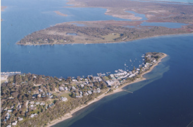 Lakes Entrance Historical Society
Photograph - Metung, 2005 c
... Aerial Photograph...Colour aerial photograph of Shaving Point Gippsland Lakes...Aerial Photograph Settlement Waterways Metung Colour aerial ...Colour aerial photograph of Shaving Point Gippsland Lakes looking eastward over Mosquito Point Bancroft Bay in between Metung Victoriaaerial photograph, settlement, waterways, metung -
 Lakes Entrance Historical Society
Photograph - Lakes Entrance, 1993c
... Aerial Photograph...Colour aerial photograph of Blair Road showing first few...Red brick house on right O'Donnells Aerial Photograph ...Red brick house on right O'DonnellsColour aerial photograph of Blair Road showing first few dwellings of housing estate Tarra Landing in background Lakes Entrance Victoriaaerial photograph, township -
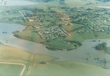 Lakes Entrance Historical Society
Photograph - Mitchell River in flood Bairnsdale Victoria, 1/04/1990 12:00:00 AM
... Colour aerial photograph of Mitchell River in flood showing... areas Rivers Floods Colour aerial photograph of Mitchell River ...There was a deluge overnight in headwaters of Mitchell and Avon Rivers so the rivers rose overnight and flooded low lying areasColour aerial photograph of Mitchell River in flood showing Clifton Waters Village in centre and township of Wy Yung near Bairnsdale Victoriarivers, floods -
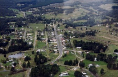 Linton and District Historical Society Inc
Photograph, Aerial photo of Sussex Street, Linton, 1991, 1991
... Aerial photograph taken 1.9.1991 Linton looking north along... "Linton Township, Vic. 1st Sept 1991". Aerial photograph taken ...Photograph taken by Historical Society member Alan Giles, on a joy flight over Linton.Aerial photograph taken 1.9.1991 Linton looking north along Sussex St showing Edinburgh Reserve to Recreation Reserve and Ballarat Road."Linton Township, Vic. 1st Sept 1991".linton township, sussex street linton