Showing 629 items
matching box william
-
 Ballarat Heritage Services
Photograph - Colour, Stonework and well, Old Sarum, England, English Heritage Site, 2016, 01 November 2016
William the Conqueror inherited Old Sarum from the last Saxon king of England. It was an ideal site for a royal castle. It was here in 1070 that William paid off his army after a long and bitter campaign in northern England. It was here in 1086 that he called together all the major landholders in England so they could swear allegiance to him. It was a crucial moment. The Domesday Book was being written, a threatened Viking invasion had only just been averted and William's eldest son was in armed rebellion. Old Sarum was an important place where this Norman king of England held power. In 1794 the Ordnance Survey set out to check the accuracy of the first mapping of Southern England, which had begun ten years earlier. From a point just below Old Sarum Lieutenant William Mudge laid out a base-line 36,574 feet (11,253 metres) long. From each end of the line the positions of distant places were plotted using a huge theodolite made in 1791 by Jesse Ramsden. The accuracy of the process, which was repeated all over England, depended on Jesse Ramsden's craftsmanship and on William Mudge's surveying skill in setting out this first base-line from Old Sarum. The nearer end of Mudge's line is marked by an inscribed stone beside the modern A345 at Old Sarum. ordnance survey, william mudge, jesse ramsden, william the conqueror, old sarum, saxon, 1086, england -
 Ballarat Heritage Services
Photograph - Colour, Stonework, Old Sarum, England, English Heritage Site, 01 November 2016
William the Conqueror inherited Old Sarum from the last Saxon king of England. It was an ideal site for a royal castle. It was here in 1070 that William paid off his army after a long and bitter campaign in northern England. It was here in 1086 that he called together all the major landholders in England so they could swear allegiance to him. It was a crucial moment. The Domesday Book was being written, a threatened Viking invasion had only just been averted and William's eldest son was in armed rebellion. Old Sarum was an important place where this Norman king of England held power. In 1794 the Ordnance Survey set out to check the accuracy of the first mapping of Southern England, which had begun ten years earlier. From a point just below Old Sarum Lieutenant William Mudge laid out a base-line 36,574 feet (11,253 metres) long. From each end of the line the positions of distant places were plotted using a huge theodolite made in 1791 by Jesse Ramsden. The accuracy of the process, which was repeated all over England, depended on Jesse Ramsden's craftsmanship and on William Mudge's surveying skill in setting out this first base-line from Old Sarum. The nearer end of Mudge's line is marked by an inscribed stone beside the modern A345 at Old Sarum. ordnance survey, william mudge, jesse ramsden, william the conqueror, old sarum, saxon, 1086, england -
 Ballarat Heritage Services
Photograph - Colour, Sign Explaining toilets, Old Sarum, England, English Heritage Site, 01/11/2016
William the Conqueror inherited Old Sarum from the last Saxon king of England. It was an ideal site for a royal castle. It was here in 1070 that William paid off his army after a long and bitter campaign in northern England. It was here in 1086 that he called together all the major landholders in England so they could swear allegiance to him. It was a crucial moment. The Domesday Book was being written, a threatened Viking invasion had only just been averted and William's eldest son was in armed rebellion. Old Sarum was an important place where this Norman king of England held power. In 1794 the Ordnance Survey set out to check the accuracy of the first mapping of Southern England, which had begun ten years earlier. From a point just below Old Sarum Lieutenant William Mudge laid out a base-line 36,574 feet (11,253 metres) long. From each end of the line the positions of distant places were plotted using a huge theodolite made in 1791 by Jesse Ramsden. The accuracy of the process, which was repeated all over England, depended on Jesse Ramsden's craftsmanship and on William Mudge's surveying skill in setting out this first base-line from Old Sarum. The nearer end of Mudge's line is marked by an inscribed stone beside the modern A345 at Old Sarum. Colour photograph of a sign explaining toilets at Old Sarum, English Heritage Siteordnance survey, william mudge, jesse ramsden, william the conqueror, old sarum, saxon, 1086,, england -
 Ballarat Heritage Services
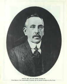
Image - Black and White, The Right Honourable William Morris Hughes
William Hughes was Prime Minister if the COmmonwealth of Austrlai, who led Australia throughout World War One. This image was copied from 'Australia's Fighting Sons of the Empire'. Black and white image showing The Right Honourable William Morris Hughesanzac, world war one, prime minister william morris hughes, william hughes -
 Ballarat Heritage Services
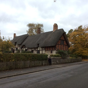
Photograph - Colour, Anne Hathway's Cottage, Stratford upon Avon, England, 2017
Anne Hathaway was married to William Shakespeare.Colour photograph of Anne Hathaway's Cottage. anne hathaway's cottage, stratford upon avon, england, thatched roof -
 Ballarat Heritage Services
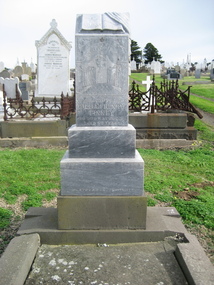
Photograph - Colour, Clare Gervasoni, William Henry Finney Gravestone, Warrnambool Cemetery, 27/07/2009
Willima Finney died on 20 May 1911, aged 60 years.Headstone for William Finney in the Warrnambool Cemetery. Includes sculptural anchor, open gates, open book, draped cloth, arch, masonic symbol.cemetery art, headstone art -
 Ballarat Heritage Services
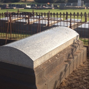
Photograph - Photograph - Colour, Clare Gervasoni, Gravestone for William Rutledge, Tower Hill Cemetery, 26/07/2009
Colour photograph of a headstone in the Tower Hill Cemetery.In memory of William Rutledge of Farnham Park Died 1st June 1876 aged 70 years also of Eliza his wife died 31st August 1888, aged 68 years. tower hill cemetery, william rutledge, eliza rutledge -
 Ballarat Heritage Services
Photograph - Colour, Clare Gervasoni, Tower Hill Cemetery, 2009, 26/07/2009
Colour photograph of a headstone in the Tower Hill Cemetery.In memory of William Rutledge of Farnham Park Died 1st June 1876 aged 70 years also of Eliza his wife died 31st August 1888, aged 68 years. tower hill cemetery, william rutledge, eliza rutledge -
 Ballarat Heritage Services
Photograph - Photograph - Colour, Clare Gervasoni, Tower Hill Cemetery, 2009, 26/07/2009
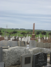
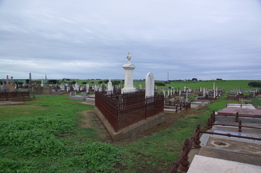
The Tower Hill Cemetery is located near Koroit on the north side of the Princes Highway The, between Port Fairy and Warrnambool. The first burial at Tower Hill Cemetery took place in 1856. Over 150 years there has been over 8,000 burials. Around 45 percent of the burials are in unmarked graves.Colour photograph of a headstone in the Tower Hill Cemetery.tower hill cemetery, william rutledge, eliza rutledge -
 Ballarat Heritage Services
Photograph - Photograph - Colour, Clare Gervasoni, Tower Hill Cemetery, 2009, 26/07/2009
The Tower Hill Cemetery is located near Koroit on the north side of the Princes Highway The, between Port Fairy and Warrnambool. The first burial at Tower Hill Cemetery took place in 1856. Over 150 years there has been over 8,000 burials. Around 45 percent of the burials are in unmarked graves.Colour photograph of a headstone in the Tower Hill Cemetery.tower hill cemetery, william rutledge, eliza rutledge -
 Ballarat Heritage Services
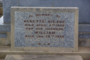
Photograph - Colour, Clare Gervasoni, Kinnane Headstone, Tower Hill Cemetery, 26/07/2009
Colour photograph of a headstone in the Tower Hill Cemetery.In Memory of Annette Kinane Died Spril 4th 1948 and her husband William Died Jan 29th 1949. RIPtower hill cemetery, annette kinane, william kinane -
 Ballarat Heritage Services
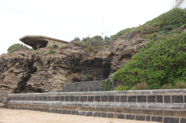
Photograph - Colour, Clare Gervasoni, Buckley's Cave, Point Lonsdale, 31/03/2015
Colour photograph of William Buckley's Grave on the coastline at Port Lonsdale. william buckley, aborigines, point lonsdale, buckley's cave -
 Ballarat Heritage Services
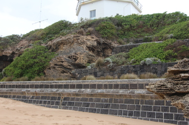
Photograph - Colour, Clare Gervasoni, Buckley's Cave, Point Lonsdale, 31/03/2015
Colour photograph of William Buckley's Grave on the coastline at Port Lonsdale. william buckley, aborigines, point lonsdale, buckley's cave, waddawurrung -
 Ballarat Heritage Services
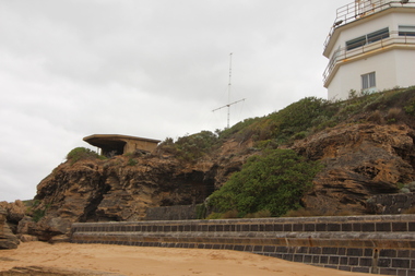
Photograph - Colour, Clare Gervasoni, Buckley's Cave, Point Lonsdale, 31/03/2015
Colour photograph of William Buckley's Grave on the coastline at Port Lonsdale. william buckley, aborigines, point lonsdale, buckley's cave, waddawurrung -
 Ballarat Heritage Services
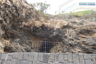
Photograph - Colour, Clare Gervasoni, Buckley's Cave, Point Lonsdale, 31/03/2015
Colour photograph of William Buckley's Grave on the coastline at Port Lonsdale. william buckley, aborigines, point lonsdale, buckley's cave, waddawurrung -
 Ballarat Heritage Services
Photograph - Colour, Clare Gervasoni, Buckley's Cave, Point Lonsdale, 31/03/2015
Colour photograph of William Buckley's Grave on the coastline at Port Lonsdale. william buckley, aborigines, point lonsdale, buckley's cave -
 Ballarat Heritage Services
Photograph - Colour, Clare Gervasoni, Buckley's Cave, Point Lonsdale, 31/03/2015
Colour photograph of William Buckley's Grave on the coastline at Port Lonsdale. william buckley, aborigines, point lonsdale, buckley's cave -
 Ballarat Heritage Services
Photograph - Colour, Old Sarum, England, 2017, 01 November 2016
William the Conqueror inherited Old Sarum from the last Saxon king of England. It was an ideal site for a royal castle. It was here in 1070 that William paid off his army after a long and bitter campaign in northern England. It was here in 1086 that he called together all the major landholders in England so they could swear allegiance to him. It was a crucial moment. The Domesday Book was being written, a threatened Viking invasion had only just been averted and William's eldest son was in armed rebellion. Old Sarum was an important place where this Norman king of England held power. In 1794 the Ordnance Survey set out to check the accuracy of the first mapping of Southern England, which had begun ten years earlier. From a point just below Old Sarum Lieutenant William Mudge laid out a base-line 36,574 feet (11,253 metres) long. From each end of the line the positions of distant places were plotted using a huge theodolite made in 1791 by Jesse Ramsden. The accuracy of the process, which was repeated all over England, depended on Jesse Ramsden's craftsmanship and on William Mudge's surveying skill in setting out this first base-line from Old Sarum. The nearer end of Mudge's line is marked by an inscribed stone beside the modern A345 at Old Sarum. ordnance survey, william mudge, jesse ramsden, william the conqueror, old sarum, saxon, 1086, england -
 Ballarat Heritage Services
Photograph - Photograph - Colour, Old Sarum, England, 2016, 01/11/2016
William the Conqueror inherited Old Sarum from the last Saxon king of England. It was an ideal site for a royal castle. It was here in 1070 that William paid off his army after a long and bitter campaign in northern England. It was here in 1086 that he called together all the major landholders in England so they could swear allegiance to him. It was a crucial moment. The Domesday Book was being written, a threatened Viking invasion had only just been averted and William's eldest son was in armed rebellion. Old Sarum was an important place where this Norman king of England held power. In 1794 the Ordnance Survey set out to check the accuracy of the first mapping of Southern England, which had begun ten years earlier. From a point just below Old Sarum Lieutenant William Mudge laid out a base-line 36,574 feet (11,253 metres) long. From each end of the line the positions of distant places were plotted using a huge theodolite made in 1791 by Jesse Ramsden. The accuracy of the process, which was repeated all over England, depended on Jesse Ramsden's craftsmanship and on William Mudge's surveying skill in setting out this first base-line from Old Sarum. The nearer end of Mudge's line is marked by an inscribed stone beside the modern A345 at Old Sarum. Colour photograph of Old Sarum, England.ordnance survey, william mudge, jesse ramsden, william the conqueror, old sarum, saxon, 1086, england -
 Ballarat Heritage Services
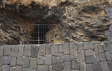
Photograph - Colour, Earth Banks, Old Sarum, England, 01 November 2016
William the Conqueror inherited Old Sarum from the last Saxon king of England. It was an ideal site for a royal castle. It was here in 1070 that William paid off his army after a long and bitter campaign in northern England. It was here in 1086 that he called together all the major landholders in England so they could swear allegiance to him. It was a crucial moment. The Domesday Book was being written, a threatened Viking invasion had only just been averted and William's eldest son was in armed rebellion. Old Sarum was an important place where this Norman king of England held power. In 1794 the Ordnance Survey set out to check the accuracy of the first mapping of Southern England, which had begun ten years earlier. From a point just below Old Sarum Lieutenant William Mudge laid out a base-line 36,574 feet (11,253 metres) long. From each end of the line the positions of distant places were plotted using a huge theodolite made in 1791 by Jesse Ramsden. The accuracy of the process, which was repeated all over England, depended on Jesse Ramsden's craftsmanship and on William Mudge's surveying skill in setting out this first base-line from Old Sarum. The nearer end of Mudge's line is marked by an inscribed stone beside the modern A345 at Old Sarum. ordnance survey, william mudge, jesse ramsden, william the conqueror, old sarum, saxon, 1086, england -
 Ballarat Heritage Services
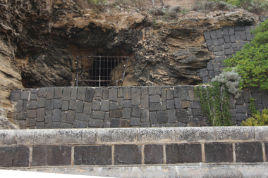
Photograph - Colour, Dorothy Wickham, Earth Banks, Old Sarum, England, 2016, 01 November 2016
William the Conqueror inherited Old Sarum from the last Saxon king of England. It was an ideal site for a royal castle. It was here in 1070 that William paid off his army after a long and bitter campaign in northern England. It was here in 1086 that he called together all the major landholders in England so they could swear allegiance to him. It was a crucial moment. The Domesday Book was being written, a threatened Viking invasion had only just been averted and William's eldest son was in armed rebellion. Old Sarum was an important place where this Norman king of England held power. In 1794 the Ordnance Survey set out to check the accuracy of the first mapping of Southern England, which had begun ten years earlier. From a point just below Old Sarum Lieutenant William Mudge laid out a base-line 36,574 feet (11,253 metres) long. From each end of the line the positions of distant places were plotted using a huge theodolite made in 1791 by Jesse Ramsden. The accuracy of the process, which was repeated all over England, depended on Jesse Ramsden's craftsmanship and on William Mudge's surveying skill in setting out this first base-line from Old Sarum. The nearer end of Mudge's line is marked by an inscribed stone beside the modern A345 at Old Sarum. King William devised the Domesday Book, considered to be the first listing of land owners in England. Among the names is that of D'Arques, from Normandy, France. Descendants of this family later emigrated from England and settled in Victoria, Australia under the surname 'Dark'. ordnance survey, william mudge, jesse ramsden, william the conqueror, old sarum, saxon, 1086, england -
 Ballarat Heritage Services
Photograph - Colour, Earth Banks, Old Sarum, England, 2016, 01 November 2016
William the Conqueror inherited Old Sarum from the last Saxon king of England. It was an ideal site for a royal castle. It was here in 1070 that William paid off his army after a long and bitter campaign in northern England. It was here in 1086 that he called together all the major landholders in England so they could swear allegiance to him. It was a crucial moment. The Domesday Book was being written, a threatened Viking invasion had only just been averted and William's eldest son was in armed rebellion. Old Sarum was an important place where this Norman king of England held power. In 1794 the Ordnance Survey set out to check the accuracy of the first mapping of Southern England, which had begun ten years earlier. From a point just below Old Sarum Lieutenant William Mudge laid out a base-line 36,574 feet (11,253 metres) long. From each end of the line the positions of distant places were plotted using a huge theodolite made in 1791 by Jesse Ramsden. The accuracy of the process, which was repeated all over England, depended on Jesse Ramsden's craftsmanship and on William Mudge's surveying skill in setting out this first base-line from Old Sarum. The nearer end of Mudge's line is marked by an inscribed stone beside the modern A345 at Old Sarum. ordnance survey, william mudge, jesse ramsden, william the conqueror, old sarum, saxon, 1086, england -
 Ballarat Heritage Services
Photograph - Photograph - Colour, Castle toilets, Old Sarum, England, 2016, 01/11/2016
William the Conqueror inherited Old Sarum from the last Saxon king of England. It was an ideal site for a royal castle. It was here in 1070 that William paid off his army after a long and bitter campaign in northern England. It was here in 1086 that he called together all the major landholders in England so they could swear allegiance to him. It was a crucial moment. The Domesday Book was being written, a threatened Viking invasion had only just been averted and William's eldest son was in armed rebellion. Old Sarum was an important place where this Norman king of England held power. In 1794 the Ordnance Survey set out to check the accuracy of the first mapping of Southern England, which had begun ten years earlier. From a point just below Old Sarum Lieutenant William Mudge laid out a base-line 36,574 feet (11,253 metres) long. From each end of the line the positions of distant places were plotted using a huge theodolite made in 1791 by Jesse Ramsden. The accuracy of the process, which was repeated all over England, depended on Jesse Ramsden's craftsmanship and on William Mudge's surveying skill in setting out this first base-line from Old Sarum. The nearer end of Mudge's line is marked by an inscribed stone beside the modern A345 at Old Sarum. Colour photographs of Castle toilets at Old Sarum, England. The toilets are constructed of stone. ordnance survey, william mudge, jesse ramsden, william the conqueror, old sarum, saxon, 1086, england, subjects, toilets -
 Ballarat Heritage Services
Photograph - Colour, William Collard Smith Memorial, Ballarat Town Hall, c1892, 15/09/2017
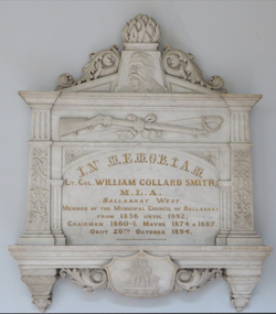
Photograph of a marble memorial in the Ballarat Town Hall dedicated to William Collard Smith.In Memoriam Lt. Col. William Collard Smith M.L.A. Ballaarat West Member of the Municipal Council of Ballaarat From 1856 until 1892 Chairmand 1860-1. Mayor 1874 and 1887 Obiit 20th Ovtober 1894.ballarat town hall, sculpture, coat of arms, duke of clarnence and avondale, william morris, rifles, city of ballarat coat of arms -
![Photograph - Colour, William Collard Smith Memorial, Ballarat Town Hall [detail], c1892, 15/09/2017](/media/collectors/57a00a4fd0cdd1210422a51e/items/59c8caaa21ea740dac0b5533/item-media/59c8cade21ea740dac0b6972/item-fit-380x285.jpg) Ballarat Heritage Services
Ballarat Heritage ServicesPhotograph - Colour, William Collard Smith Memorial, Ballarat Town Hall [detail], c1892, 15/09/2017
Photograph of the City of Ballarat Coat of Arms on a marble memorial in the Ballarat Town Hall dedicated to William Collard Smith.In Memoriam Lt. Col. William Collard Smith M.L.A. Ballaarat West Member of the Municipal Council of Ballaarat From 1856 until 1892 Chairmand 1860-1. Mayor 1874 and 1887 Obiit 20th Ovtober 1894.ballarat town hall, sculpture, coat of arms, duke of clarnence and avondale, william morris, rifles, city of ballarat coat of arms