Showing 3476 items matching " bridge road"
-
 Eltham District Historical Society Inc
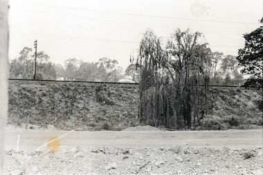
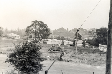
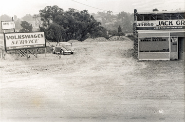
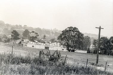
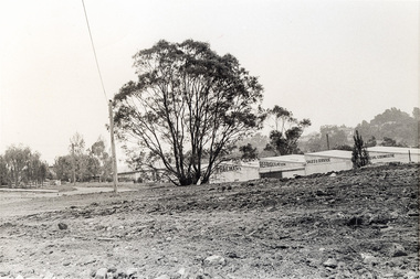
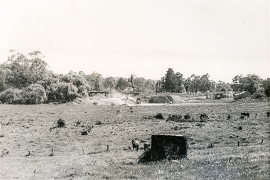
Photograph, Sherbourne Road, Para Road and Simms Road at Briar Hill/Montmorency prior to the upgrade of Sherbourne Road Railway bridge, c.1970
... /Montmorency prior to the upgrade of Sherbourne Road Railway bridge, c... time depicting Sherbourne Road, Para Road and Simms Road... time depicting Sherbourne Road, Para Road and Simms Road ...Collection of photographs probably taken around the same time depicting Sherbourne Road, Para Road and Simms Road at Briar Hill/Montmorency prior to the upgrade of Sherbourne Road Railway bridge, c.1970. Photo 01648_ 19 This home owned by Mrs Cameron. Her daughter married a Mr Davey, for whom Davey Road was named - email from M. Jones 20/07/2015 Photographer unknownThese photos are very significant in the documentation of the development of the Briar Hill and Montmorency areas and the changes in the physical landscape along the railway line area.20 black and white prints 9 cm x 13 cm.1970, briar hill, davey road, montmorency, para road, cameron, davey, sherbourne road, simms road, railway line, roadworks -
 Eltham District Historical Society Inc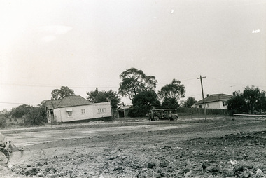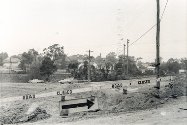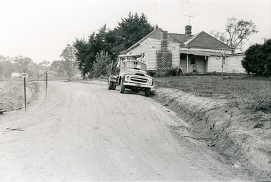
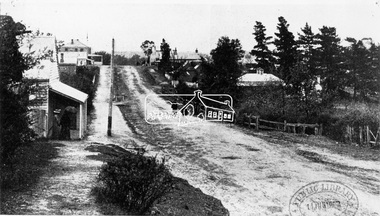
Photograph, View in Eltham looking south along Main road from Bridge Street, 1902
... View in Eltham looking south along Main road from Bridge... of the intersection of Bridge Street with Main Road. Post Office (Anne... of the intersection of Bridge Street with Main Road. Post Office (Anne ...Looking south along Main Road from the south side of the intersection of Bridge Street with Main Road. Post Office (Anne Hunniford Postmistress) on left then the Commercial Bank of Australasia building. The house on the right, 'Derril,' was purchased by Walter Gahan in 1924 and was demolished in 1968 when Main Road was widened. In the distance on the left is Watson's Hotel and on the right (opposite side of the main road, Morris's Hotel Cross Ref: 0624This photo forms part of a collection of photographs gathered by the Shire of Eltham for their centenary project book,"Pioneers and Painters: 100 years of the Shire of Eltham" by Alan Marshall (1971). The collection of over 500 images is held in partnership between Eltham District Historical Society and Yarra Plenty Regional Library (Eltham Library) and is now formally known as the 'The Shire of Eltham Pioneers Photograph Collection.' It is significant in being the first community sourced collection representing the places and people of the Shire's first one hundred years.Digital image Print 14 x 24 cm 35 mm B&W negativeanne jane hunniford (1855-1928), bridge street, commercial bank of australia, derril, eltham, gahan house, main road, morris's hotel, post office, shire of eltham pioneers photograph collection, watsons hotel -
 University of Melbourne, Burnley Campus Archives
Plan, Circus Site, c. 1990
... to Bridge Road."... to Bridge Road." (1) Copy of Plan: City of Richmond City Engineers ...(1) Copy of Plan: City of Richmond City Engineers Department Circus Site: includes Descriptions of Site Preparation, Plant List and Plant Order List. (2) On tracing paper: Plant Plan. (3) On tracing paper: "Yarra Vegetation Survey - Site 3," Plant Plan(1) Handwritten on reverse, "Richmond Council - Yarra Blvd to Bridge Road."circus, survey, richmond, vegetation survey, colin mock, yarra river -
 Melbourne Tram Museum
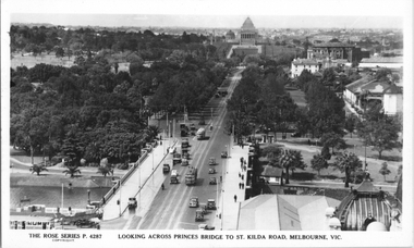
Postcard, Rose Stereograph Co, "Looking across Princes Bridge to St Kilda Road, Melbourne", late 1930s
... "Looking across Princes Bridge to St Kilda Road, Melbourne"... Princes Bridge to St Kilda Road, Melbourne" taken from... on the rear. "Looking across Princes Bridge to St Kilda Road ...Rose Series postcard No. P 4287, titled "Looking across Princes Bridge to St Kilda Road, Melbourne" taken from the Flinders St station clocktower. The photo looks down to the Shrine of Remembrance. Has two W2 class trams in St Kilda Road, a W2 in City Road, and a Maximum Traction type C or E class tramcar at the Batman Ave terminus. Includes some horse-drawn vehicles and possibly an overhead tower truck at the intersection with City Road. Yields information about St Kilda Road mid to late 1930sPostcard - printed real photograph with Rose Stereograph Co. name on the rear.trams, tramways, w2 class, swanston st, batman ave, st kilda road, shrine of remembrance -
 Melbourne Tram Museum
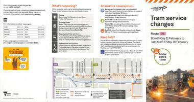
Pamphlet - Tram works on Swan St, Yarra Trams, Tram Service Changes, 2022
... Wallen Road bridge... and Wallen Road Bridge, Richmond .3 - as for .1 - track..., four fold DL - Tram Network Upgrade - Swan St and Wallen Road... Road Bridge, Richmond .3 - as for .1 - track reconstruction ....1 - pamphlet provided at tram stops giving details of the works for 70 .2 - ditto - for Tram Network Upgrade - Swan St and Wallen Road Bridge, Richmond .3 - as for .1 - track reconstruction in Swan St between Stanley St and Stawell St Richmond or BurnleyShows the methods that Yarra Trams customers are advised of changes due to track replacement works. .1>.2 - Pamphlet - DL, four fold DL - Tram Service changes - 11/2022 to 18/2/2022 - Route 70 .3>.4 - Pamphlet - DL, four fold DL - Tram Network Upgrade - Swan St and Wallen Road Bridge, Richmond .5 - Newspaper clipping - Tram works on Swan Sttram works, track work, yarra trams, ptv, bridges, trams, tramways, richmond, burnley, route 70, wallen road bridge -
 Eltham District Historical Society Inc
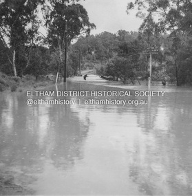
Album - Photograph, J.A. McDonald, Eltham-Diamond Creek Road, 21 Oct. 1953
... Wattletree Road Bridge... to the Wattletree Road bridge being built, Railway Parade extended up... to the Wattletree Road bridge being built, Railway Parade extended up ...18 October 1956 Flood level on road at corner of Railway Parade. On the immediate left out of view is Mrs Lucy Egan's home. That house still stands today nestled up against the Wattletree Road Bridge on the other side built in 1959 and is owned by the Bakos family purchased by Mrs Heather Bakos in 1960.. Prior to the Wattletree Road bridge being built, Railway Parade extended up the alignment of present-day Gastons Road to the Eltham-Diamond Creek road which ran past the entrance of the present-day carpark for Edendale Farm. This view is looking west across the Glen Park Bridge, and the beginning of Wattletree Road which sweeps around to the right in the distance. Progress Road does not exist though a road reserve is present on maps.Record of various Shire of Eltham infrastructure works undertaken during the period of 1952-1962 involving bridge and road reconstruction projects, sometimes with Eltham Shire Council Project Reference numbers quoted. It was during this period that a number of significant improvements were made to roads and new bridges constructed within the shire that remain in place as of present day (2022). In many situations, the photos provide a tangible visible record of infrastructure that existed throughout the early days of the Shire. The album was put together by or under the direction of the Shire Engineer, J.A. McDonald.infrastructure, road construction, shire of eltham, bridge construction, eltham north, floods, floodwater, glen park bridge, 1956-10-18, diamond creek (creek), eltham, railway parade, wattletree road, wattletree road bridge, gastons road -
 Whitehorse Historical Society Inc.
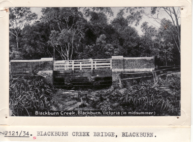
Photograph - Postcard, Blackburn Creek Bridge Blackburn
... Blackburn Road Bridge.... (in midsummer)|Shows Blackburn Road Bridge... Mitcham melbourne Blackburn Road Bridge Blackburn Black and white ...Black and white postcard entitled Blackburn Creek Blackburn. (in midsummer)|Shows Blackburn Road Bridgeblackburn road bridge, blackburn -
 Eltham District Historical Society Inc
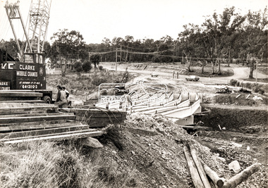
Photograph, Construction of new bridge over the Plenty River, Main Road, Lower Plenty, c.Aug. 1966
... Construction of the Main Road bridge over the Plenty River...Marking on back of photograph - Plenty River Bridge Main... melbourne Construction of the Main Road bridge over the Plenty River ...Construction of the Main Road bridge over the Plenty River. Includes structural members, construction personnel, vehicles and a Clarke mobile crane.Local significanceBlack and white printMarking on back of photograph - Plenty River Bridge Main Road 1969 (sic)lower plenty, main road, plenty river, bridge, bridge construction, civil engineering, cranes, mobile cranes -
 Melbourne Tram Museum
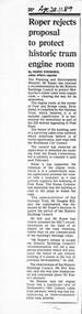
Newspaper - Photocopy, The Age Newspaper, Roper rejects proposal to protect historic tram engine room, 28-11-1989
... Bridge Road... winding or Engine house on the corner of Bridge and Punt Roads... or Engine house on the corner of Bridge and Punt Roads Richmond ...Provides a report from The Age, 28-11-1989 written by Ingrid Swendsen, about the rejection by the Planning and Environment Minister , Tom Roper to protect the former cable tram winding or Engine house on the corner of Bridge and Punt Roads Richmond, despite the recommendation of the Historic Buildings Council to add it to the register. The building was later demolished by the Roads Corporation to widen the intersection. The Tramways have a small sub-station on the site. Quotes Douglas Hill of the National Trust and Roz Hansen of the Historic Buildings Council. Provides a report on the rejection of a recommendation to protect a historic building.Photocopy of a newspaper clipping from The Age 28-11-1989 - Roper rejects proposal to protect historic tram engine roomtrams, tramways, cable trams, engine house, winding house, punt road, bridge road, demolition, richmond, historic buildings council -
 Eltham District Historical Society Inc
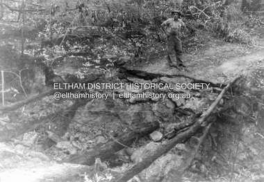
Album - Photograph, J.A. McDonald, Black Cameron Road, Smiths Gully, Aug. 1962
... Black Cameron Road Bridge over Salters Rush Creek following... melbourne Black Cameron Road Bridge over Salters Rush Creek ...Black Cameron Road Bridge over Salters Rush Creek following bush fires 15-16 Jan. 1962Record of various Shire of Eltham infrastructure works undertaken during the period of 1952-1962 involving bridge and road reconstruction projects, sometimes with Eltham Shire Council Project Reference numbers quoted. It was during this period that a number of significant improvements were made to roads and new bridges constructed within the shire that remain in place as of present day (2022). In many situations, the photos provide a tangible visible record of infrastructure that existed throughout the early days of the Shire. The album was put together by or under the direction of the Shire Engineer, J.A. McDonald.H941 stamped on reverse (film processing #)infrastructure, shire of eltham, bridge construction, road construction, 1962-08, bushfires, victorian bushfires - 1962, black cameron road, smiths gully -
 Eltham District Historical Society Inc
Negative - Photograph, Eltham War Memorial Obelisk 1914-1918, cnr. Main Road and Bridge Street, c.1925
... Eltham War Memorial Obelisk 1914-1918, cnr. Main Road and... at the corner of Bridge and Main Roads in 1919. In 1943 (WW2) the local... at the corner of Bridge and Main Roads in 1919. In 1943 (WW2) the local ...Located on what was referred to as Obelisk Corner, improvements have been been made since the unveiling in August 1919 with the provision of a stone retaining wall topped with a chain link and granite stone boundary, most likely in conjunction with improvements to the intersection into Main Road. Along with the use of the name Obelisk Corner, the Bridge Street bridge was also known as Obelisk Bridge. The Eltham Obelisk was originally located at the corner of Bridge and Main Roads in 1919. In 1943 (WW2) the local community commenced plans to establish the Eltham War Memorial, a living memorial to benefit the children as opposed to a one in stone as per the obelisk. The Eltham War Memorial Trust was established in 1945. In 1947 the Trust intended for the Obelisk to be relocated from Bridge Street and Main Road to the Garden of Remembrance which was planned as part of the Baby Health Centre which was to be the first of three buildings of the Eltham War Memorial to be built in 1951. In 1951 the Eltham RSL was invited to be represented on the Eltham War Memorial Trust. Around this time, with pending roadworks, the obelisk was relocated to the front garden of the Eltham RSL sub branch on Main Road for safe keeping. In 2007, a suggestion was proposed by Harry Gilham (President, EDHS) to John Cohen (ERSL) to claim a special site along with the historic Shillinglaw trees on the now vacant former Eltham Shire Office site adjacent to the Eltham War Memorial precinct for relocation of the obelisk. In 2010 following the financial collapse and sale of the Eltham RSL Sub-Branch property and amalgamation with the Montmorency Eltham RSL sub-branch, the location of the obelisk was again in immediate jepoardy and in conjunction with Nillumbik Shire Council, the obelisk was relocated in front of the Eltham War Memorial buildings in preparation for the Dawn Service on Anzac Day 2012.This photo forms part of a collection of photographs gathered by the Shire of Eltham for their centenary project book,"Pioneers and Painters: 100 years of the Shire of Eltham" by Alan Marshall (1971). The collection of over 500 images is held in partnership between Eltham District Historical Society and Yarra Plenty Regional Library (Eltham Library) and is now formally known as the 'The Shire of Eltham Pioneers Photograph Collection.' It is significant in being the first community sourced collection representing the places and people of the Shire's first one hundred years.Digital image 4 x 5 inch B&W Negsepp, shire of eltham pioneers photograph collection, eltham, main road, eltham war memorial, bridge street, obelisk, obelisk corner -
 Eltham District Historical Society Inc
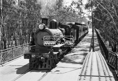
Photograph, VR Commissioner's Special train, steam locomotive D3-639 crossing the Echuca-Moama Road Rail Bridge over the Murray River from Moama, NSW to Echuca, Victoria, 1962
... crossing the Echuca-Moama Road Rail Bridge over the Murray River...Echuca-Moama Road Rail Bridge... crossing the Echuca-Moama Road Rail Bridge over the Murray River... crossing the Echuca-Moama Road Rail Bridge over the Murray River ...VR Commissioner's Special train, steam locomotive D3-639 crossing the Echuca-Moama Road Rail Bridge over the Murray River from Moama, NSW to Echuca, Victoria. Commissioner Edgar Henry Brownbill on footplate, 1962. Commissioner Edgar Henry Brownbill was in office 1957 to 1967. George Coop advises - "The train on the Eltham/Moama bridge is actually the Commissioner’s Special on one of its inspection tours of the VR rail system. This was a very grand special train with accommodation for the Commissioner and staff in carriages also used once for the Royal Train and other State purposes. You can just see the Commissioner of the day, dressed in his suit and wearing engine drivers gloves, standing in the loco cab doorway. A good ‘hands on’ impression is created amongst local staff if can be seen that the boss is no ‘desk jockjey’. The observation car on the back was originally made for the ’Spirit of Progress’. I climbed up onto the bridge iron plate work to get this view. It was safe enough as the cantilevered pedestrian walkway was still on the east side at the time." "I was resident in Echuca from Jan. ’59 to approx. May ’64. At that time the single Echuca/Moama bridge was a combined road/rail bridge. The rail gauge was 5’3” and still is, I believe, on the new bridge that sits just upstream of the old one. This rail line into NSW has always been 5’3" gauge because it has no connection with any NSW tracks. The old Echuca/Moama bridge, locally called the ‘Iron Bridge’ has, over years, undergone some structural changes. The two lattice iron hoops arcing over the roadway have been raised and lowered and changed design. Presently a pedestrian walkway is cantilevered off the west (or downstream) side of the bridge. It used to be on the eastern side. Guess changes went in when new rail bridge only was built on the eastern side as well." Image dated as c.1963 based on same image in Port of Echuca collection (possibly frame 32 of film) (print 19.5 x 24.5cm) On reverse in pencil: "Brown card" in black pen: "Commissioners special. F. Brown on Footplate. George C.L. Coop c1963". https://victoriancollections.net.au/items/59d575b921ea6e1278d78042 However based on frame no. 10, date set as 1962Digital TIFF file Scan of 35mm Ilford FP3 black and white negative transparencyd3-639, d3-class steam locomotive, echuca-moama road rail bridge, edgar henry brownbill, george coop collection, murray river, vr commissioner's special train -
Glenelg Shire Council Cultural Collection
Photograph - Photograph - Road and bridge, n.d
... Photograph - Road and bridge.... Unsealed road between two paddocks. Wooden bridge and railings ...Sourced from Casterton Town Hall (former Shire of Glenelg)Coloured photograph. Unsealed road between two paddocks. Wooden bridge and railings. Sign at bridge ' Bridge Load Limit 5t gross' -
 Hume City Civic Collection
Photograph, c 1980s
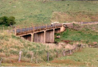
... A coloured photograph of a concrete road bridge spanning... melbourne The Gillies Bridge is situated on Wildwood Road which runs ...The Gillies Bridge is situated on Wildwood Road which runs off Lancefield Road. It spans the Deep Creek.A coloured photograph of a concrete road bridge spanning a small creek. The bridge has four arches. Two people are standing above the 4th arch on the roadway. The hillsides on either side of the valley are bare.gillies bridge, wildwood road, bridges, george evans collection -
 Greensborough Historical Society
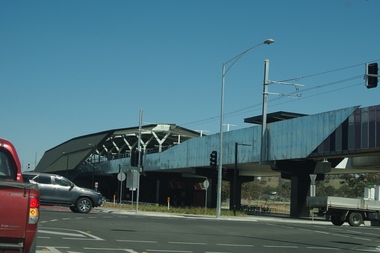
Photograph - Digital Image, Marilyn Smith, Mernda Station 2018, 27/09/2018
... bridge inn road mernda... of the line. It is sited on corner Bridge Inn Road and Schotters Road. ... mernda mernda station bridge inn road mernda Digital copy ...In 2018 GHS members visited Turner's Bakery in Mernda for lunch and continued on to visit historic sites remaining in the Mernda area. This photograph shows the newly built Mernda Station, part of the railway extension on the old Epping line. This station was opened in August 2018. Mernda is now the end of the line. It is sited on corner Bridge Inn Road and Schotters Road. Mernda is an area of rapid modern growth with a few remaining historic buildings dating from the 19th century.Digital copy of colour photographmernda, mernda historic sites, schotters road mernda, mernda station, bridge inn road mernda -
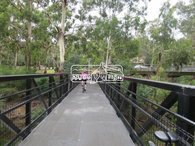
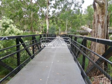
 Eltham District Historical Society Inc
Photograph, Jim Connor, Main Road, Eltham, 14 Jan 2017
... main road bridge...Eltham Gateway, Wingrove Park Trail and Main Road Bridge... melbourne Eltham Gateway, Wingrove Park Trail and Main Road Bridge ...Eltham Gateway, Wingrove Park Trail and Main Road Bridge, ElthamTomorrow's history documented todayeltham, jim connor collection, main road, eltham gateway, main road bridge, wingrove park trail -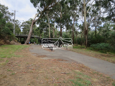
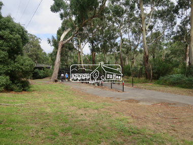
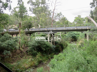
 Eltham District Historical Society Inc
Photograph, Jim Connor, Main Road, Eltham, 14 Jan 2017
... main road bridge...Eltham Gateway, Main Road Bridge, Eltham over the Diamond... melbourne Eltham Gateway, Main Road Bridge, Eltham over the Diamond ...Eltham Gateway, Main Road Bridge, Eltham over the Diamond CreekTomorrow's history documented todayeltham, jim connor collection, main road, eltham gateway, main road bridge, wingrove park trail, diamond creek -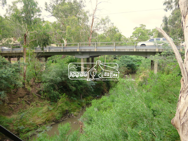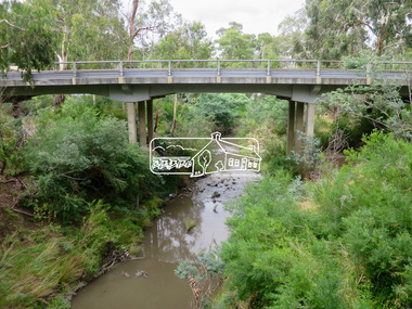
 Eltham District Historical Society Inc
Photograph, Jim Connor, Main Road, Eltham, 14 Jan 2017
... main road bridge...Eltham Gateway, Wingrove Park Trail and Main Road Bridge... melbourne Eltham Gateway, Wingrove Park Trail and Main Road Bridge ...Eltham Gateway, Wingrove Park Trail and Main Road Bridge, ElthamTomorrow's history documented todayeltham, jim connor collection, main road, eltham gateway, main road bridge, wingrove park trail