Showing 934 items
matching dam
-
 Robin Boyd Foundation
Slide, Robin Boyd, 1956-1957
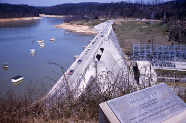
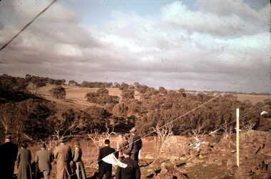
Robin Boyd developed a close friendship with the founder of the Bauhaus in Weimar Germany, Walter Gropius, who had moved to the USA in the 1930s. Through this connection, Boyd was invited to be the Massachusetts Institute of Technology (MIT) Bemis Professor at the School in the North American academic year 1956-7. Robin and Patricia Boyd, with their youngest daughter Suzy, were based in Cambridge, Massachusetts for the year. Boyd gave some lectures at MIT and he was also invited to give lectures at many other universities, allowing him to travel widely within the USA, especially on the East Coast. This gave him the opportunity to meet architects like Frank Lloyd Wright, Eero Saarinen, Paul Rudolph and many others, and visit the offices of Skidmore, Owings and Merrill, and places like Taliesin and the General Motors Technical Center Detroit. On the way home, the Boyds visited London, Berlin, Paris and Le Corbusier’s Ronchamp Chapel in France.Colour slide in a mount. Norris Dam, Anderson County, Tennessee, USA, 1936. (Architect: TVA.)Date: / Subject / Encircled 55F (Handwritten)mit bemis professorship, mit, robin boyd, slide -
 Stawell Historical Society Inc
Memorabilia - Realia, c1860's
Earthenware Crucible (Small) probably for gold smelting. Found on Banks Mining Dam Deep Leadstawell -
 The Dunmoochin Foundation
Oil Painting, Prue, 1988
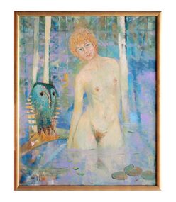
Painting depicting a female nude with blonde curly hair standing in a dam with lily pads and owl. Noneclifton pugh, painting, portrait, prue acton, dunmoochin, owl -
 Bendigo Historical Society Inc.
Slide - DAVID MCDONALD COLLECTION: EPPALOCK. CONSTRUCTION, c1960
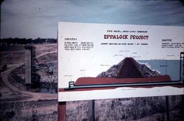
Eppalock. Construction. Water tower in the background, project board for the public to view with information about the ''Eppalock Project''. Statistics and diagram of the cross section view of the dam wall, showing the cavity in the wall and the pipeline under the wall. Markings: Eppalock Dam Observation Point Board.Agfacolorcivil engineering, water supply, eppalock -
 Nillumbik Shire Council
Painting: Eric Stephensen (b.1916), Silent Lagoon, 1966, 1966
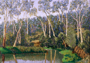
Oil on canvas. Painted at Art Historian, Bernard Smith's dam beside Karingal Drive in Eltham, Victoria. Rich, green shrubs and eucalyptus trees surround the water, reeds grow in the dam. The surrounding landscape is reflected in the water. Sloping land and bush fill the background. -
 Bendigo Historical Society Inc.
Slide - DAVID MCDONALD COLLECTION: EPPALOCK. CONSTRUCTION, c1960
Eppalock. Construction. Adults looking over the site of Lake Eppalock. Markings: Eppalock Dam Site 1960kodakcivil engineering, water supply, eppalock -
 Melbourne Water
Souvenir Pennant
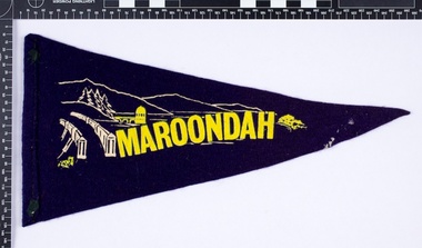
The Maroondah System was first and foremost developed as a functional component of Melbourne's Water Supply System. In addition to functionality, the Melbourne and Metropolitan Board of Works (MMBW) envisioned the Maroondah Reserve to be enjoyed aesthetically and recreationally by the public. This souvenir illustrates the realisation of the Maroondah System as a local recreational and tourist attraction in the early 20th century. The Maroondah Reserve gardens were landscaped with English-style ornamental stonework, exotic trees, flower beds and rose gardens. All features of the water supply system became widely celebrated as beauty spots that continue to be very popular to this day with tourists and locals alike. This souvenir is a product of that flourishing tourist trade. These water supply sites continue to enhance Melbourne’s charm and liveability and are now recognised as places of cultural and historic significance.This souvenir item has been curated by Melbourne Water as it represents an important historical aspect of the organisation by demonstrating the popularity of its water asset sites as recreational places and tourist attractions, and although these sites are functional parts of the water supply system, they were also designed to be enjoyed by the public both aesthetically and recreationally. Navy in colour, the pennant is double sided, with an image of the Maroondah Dam surrounding the word “Maroondah” on both sides.melbourne metropolitan board of works, mmbw, maroondah, dam, healesville, melbourne water, scenic view, souvenir, pennant, flag, textile, historic -
 Whitehorse Historical Society Inc.
Photograph, Jones Flower Farm, 1928
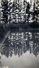
Jones Family Collection - NP2565 to NP2606. See also ND3831.Black and white photograph of reflections in the dam on Jones' Flower Farm in Mt Pleasant Road, Nunawading, in 1928.jones, bette, walter, rolf, geoffrey, arthur, keith, lionel, muriel, jones flower farm, mount pleasant road nunawading -
 Rutherglen Historical Society
Postcard, 1910-1920 (Approximate)
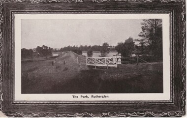
Black and white photograph, printed on postcard, with decorative printed frame. This one shows a view along the weir of Lake King, from the western end, with the bridge over the spill-way in the foreground,At bottom of photo: "The Park, Rutherglen"lake king, rutherglen park, dam -
 Kiewa Valley Historical Society
Set of 6 framed photographs - Kiewa Hydro Electric Scheme
Official photo of KHES constructed by SECVOfficial photo of KHES in the Kiewa Valley1. No. 1 Pipeline - from Anchor 1 to Anchor 5. August 1955 2. Junction Dam - General View from Downstream - May 1943 3. No. 3 Power Station - Clover Flat Camp - February 1951 4. Clover Dam - October 1954 5. View from Downstream of Junction Dam - July 1943 6. Upper Kiewa Valley Road 3 to 4 Mile - Mt Arthur in Background - July 1954 khes, secv -
 Stawell Historical Society Inc
Map, Stawell Gold Mines, Stawell Township proposed Town zoning showing Special Uses ( Mining) 1998, 1998
Shows Mining activity Stockpiles Tracks, Plant, Dams, Waste heap, Tailing Dams, IronbarksMap Printed in Colour with Coloured LegendStawell Gold Mines Pty Ltd Date April 1998mining -
 Linton and District Historical Society Inc
Photograph, Electro Hydraulic Dredge, Snake Valley, 1909
Electro hydraulic dredge Snake Valley 1909. J Mc Bennett, was an engineer back at the main base, at Dawson's dam on the Carngham Road, Between Linton and Snake Valley. These dredges were used for getting gold. The streams of water under high pressure just washed the hills and ground away. This dredge closed down early 1910. 200 H.P. motors were used and 10 in. pumps.Black and white image of three workmen, one beside mining building the other two at dredge pump outlet. Image mounted on dark brown card. Between 1904 and 1911 the Electro Hydraulic Company sought to extract gold in an area north of Linton known as the Hard Hills. By blasting water from high-pressure hoses into the hillsides, soil containing gold was washed out for sluicing. Two gravel pumps in Dawson's Dam pumped the wash through the sluices. Despite considerable investment in expensive equipment, the Company did not have a great deal of success, and the mining operation ceased in 1911.mining, gold, mining equipment, electro hydraulic dredge, dredging, sluicing, dawson's dam, snake valley, miners -
 Churchill Island Heritage Farm
Photograph - Black and white photograph of two woman in a cart, c.1939
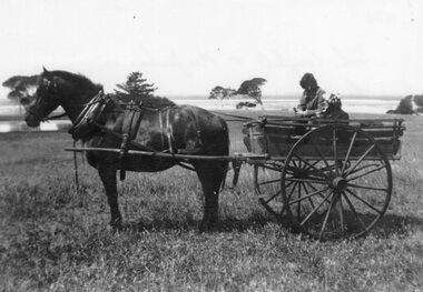
Churchill Island Heritage Farm has a large photograph collection dating from the mid-nineteenth century to the last decadeBlack and white photograph of two people in a horse drawn cart. Horse is stationary and a dam and shoreline are visible in the background.Catalogue number written in pencil on reverse. On reverse in pen '1939 Sister Campbell and Mrs Jenkins in the cart. Either on their way or just back from a trip over the Boys Home crossing to collect stores and visit the Cleelands at Newhaven'churchill island -
 Churchill Island Heritage Farm
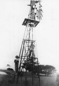
Photograph - Black and white photograph of people painting a windmill, c.1940
Churchill Island Heritage Farm has a large photograph collection dating from the mid-nineteenth century to the last decadeBlack and white photograph of two people (probably Billie Wilson and Arthur Evans) painting the windmill with a dam in the background.Catalogue number written in pencil on reverse. On reverse in pen '1940 Painting the windmill Self up at the back Billie Wilson at lower level'churchill island, windmill -
 Bendigo Historical Society Inc.
Slide - DAVID MCDONALD COLLECTION: EPPALOCK. CONSTRUCTION, c1960
Eppalock. Construction. Markings: Eppalock Dam site 1960. Shows water laying in the bottom of what will be Lake Eppalock.civil engineering, water supply, eppalock -
 Bendigo Historical Society Inc.
Slide - DAVID MCDONALD COLLECTION: EPPALOCK. CONSTRUCTION, c1961
Eppalock. Construction. Shows the base of Eppalock with a small amount of water in it. No equipment in sight. Markings: Eppalock Dam 1961.Agfacolorcivil engineering, water supply, eppalock -
 Bendigo Historical Society Inc.
Slide - DAVID MCDONALD COLLECTION: EPPALOCK CONSTRUCTION, c1961
Eppalock. Construction. Family group out looking at the construction of Lake Eppalock. Markings: Near Eppalock Dam 1961.Agfacolorcivil engineering, water supply, eppalock -
 Bendigo Historical Society Inc.
Slide - DAVID MCDONALD COLLECTION: EPPALOCK. CONSTRUCTION, c1961
Eppalock. Construction. Early stages of the construction of Lake Eppalock. Markings: Campaspe Riv. & Eppalock Dam. Project. 1961Agfacolorcivil engineering, water supply, eppalock -
 Melbourne Water
Souvenir Tea Cup, 1920s
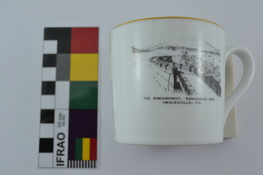
The Maroondah System was first and foremost developed as a functional component of Melbourne's Water Supply System. In addition to functionality, the Melbourne and Metropolitan Board of Works (MMBW) envisioned the Maroondah Reserve to be enjoyed aesthetically and recreationally by the public. This souvenir illustrates the realisation of the Maroondah System as a local recreational and tourist attraction in the early 20th century. The Maroondah Reserve gardens were landscaped with English-style ornamental stonework, exotic trees, flower beds and rose gardens. All features of the water supply system became widely celebrated as beauty spots that continue to be very popular to this day with tourists and locals alike. This souvenir is a product of that flourishing tourist trade. These water supply sites continue to enhance Melbourne’s charm and liveability and are now recognised as places of cultural and historic significance.This souvenir tea cup has been curated by Melbourne Water as it represents an important historical aspect of the organisation by demonstrating the popularity of its water asset sites as recreational places and tourist attractions, and although these sites are functional parts of the water supply system, they were also designed to be enjoyed by the public both aesthetically and recreationally. Additionally, the tea cup is aesthetically pleasing, representative of 1920s style and design. This porcelain tea cup with gold trim features a black and white image of the embankment at Maroondah Dam, Healesville on the front.melbourne metropolitan board of works, melbourne water, mmbw, porcelain, tea cup, maroondah, healesville -
 National Vietnam Veterans Museum (NVVM)
Photograph, Capt B. Peterson in Montaynard ceremonial dress
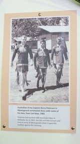
Photograph mounted on card. Capt B. Peterson in ceremonial dress with his man at Dam San base 1965photograph, capt b. peterson, ceremonial dress -
Tatura Irrigation & Wartime Camps Museum
Book, Water and Power, 1968
History of the Snowy Mmountains Scheme to 1968-9Pamphlet/soft cover/photo of Eucumbene Dam and Lake Eucumbene on front. Table of statistics on back cover. Illustratedwater, power, snowy mountains scheme, tatura, irrigatiaon, books, reference -
Stawell Historical Society Inc
Map, Stawell Gold Mines, Stawell Township 1995, 1995
Map shows details of mining activity Stockpiles, Tracks, Plant, Dams,, Waste, Tailing Dams, IronbarksPlain Printed Map in Black & White with details of MiningStawell Gold Mines Pty Ltdmining -
 Wodonga & District Historical Society Inc
Album - Hume Reservoir Australia Album - Dimensions of Hume Reservoir, Department of Public Works, N.S.W, 1927
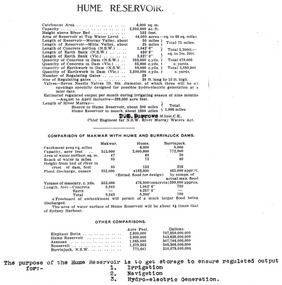
This set of photos is from a leather bound album bearing the inscription "HUME RESERVOIR AUSTRALIA" plus 'The Rt. Hon. L. C. M. S. Amery, P. C., M .P.' all inscribed in gold. It was presented to The Rt. Hon. L. C. M. S. Amery, P. C., M. P, Secretary of State for Dominion Affairs on the occasion of his visit to the Hume Reservoir on 2nd November 1927. This album is of local and national significance as it documents the planning and development of the Hume Reservoir up to 1927. It was the largest water reservoir in the British Empire. The album records the pioneering engineering work that went into its construction.Table outlining the Dimensions of the Hume Weir and comparisons with MAKWAR and BURRINJUCK DAMS, and some other comparisons. MAKWAR Dam is located on the Blue Nile about five miles south of Sennar and 175 miles south of Khartoum in Sudan. The construction of this dam started in 1922 and was completed in May 1925, while the British Empire colonised Sudan. It was officially opened on 21st January 1926. The BURRINJUCK DAM is situated in the upper catchment of the Murrumbidgee River, approximately 60 kms from Yass, N.S.W. It was built from 1907 to 1927 The stated purpose of the Hume Reservoir is to get storage to ensure regulated output for:- 1. Irrigation 2. Navigation 3. Hydro-electric Generation.hume reservoir australia, river murray waters scheme, hume dimensions -
Glenelg Shire Council Cultural Collection
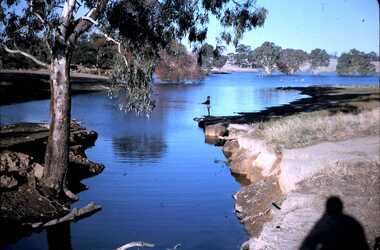
Photograph - Photograph - Erosion Gully, Casterton, Victoria, n.d
Sourced from Casterton Town Hall (Former Shire of Glenelg)Black and white photo. Eroded gully with large concrete pipes in water, looking downstreamBack: Black stamp -'57' 'Soil saving dam looking downstream' - handwritten pencil 'GB 4238' -
 Surrey Hills Historical Society Collection
Photograph, Muriel Pornitz (deceased), Quarry on site of Grovedale Road - James Street Park
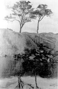
The photo is of a painting of the dam formed on land between Grovedale Road and James Street, Surrey Hills. It was painted in 1927 by Miss Muriel Pornitz, an art teacher, who lived in Grovedale Road. The land had been part of Mr James Maling Snr’s property and in the 1880s clay was removed to build houses, including his own located on the corner of Weybridge and James Streets. Maling grazed cattle on this area and used it as a dam. The land was subsequently made into parkland, the quarry / dam having been filled in after several drownings had occurred in the 1920s/1930s. See also SHP94, another copy of the same. Muriel Hedwig Lucy Pornitz lived at 22 Grovedale Road, Surrey Hills. She was born c1894 in Balwyn; died in Kew on 1 December 1982. She was the daughter of Konrad Pornitz (1864-1903) and his wife Charlotte Richardson Gooderidge (1863-1942), known as Tottie, who married in 1890. Konrad Pornitz is listed in the 1892 directory as living in Edgevale Road, Kew and the business Pornitz and Ross at 291 & 293 Little Collins Street, importers and commission merchants. The 1896 directory gives the Kew address as 176 Edgevale Road, Kew, however the business Pornitz and Ross was dissolved on 1st day of October 1892, by mutual agreement. Legal notice advised that: Mr Pornitz will hereafter carry on the business on his own behalf at the same address, under the style "Pornitz and Ross". Muriel is buried in Box Hill Cemetery (B-086-0042) along with Ulrich Horst Holm Pornitz known as Horst or Bon (d 1957) and Edith Olga Pornitz (d 1951), her brother and sister. A further sibling (Konrad b 1891) died in infancy. He is buried with his mother in Boroondara (Kew) Cemetery - C/E A 0366. Konrad died at his home 'Yarran' in Lane Cove Road, North Sydney on 31 October 1903; reported in the Sydney Morning Herald. Buried Gore Hill Cemetery, St Leonards, North Sydney. The headstone reveals he was born in Chemnitz, Saxony in 1863. Muriel was also known as Muriel Pornett. She studied at the South Australian School of Arts & Crafts in 1911 under James Ashton and Fred Britton, and at the Australian School of Etching in Sydney. She was also an illustrator and cartoonist. The photo, and the painting from which it is derived, documents the landscape prior to close settlement and is material to early building and farming in the Surrey Hills area.A black and white photograph of a painting of a landscape of parkland. Two trees are on top of a rise and are reflected at the bottom in water. The signature of the artist is in the bottom right corner: "AUST MP 192" (and the rest is cut off).(miss) muriel pornitz, grovedale road, james street, surrey hills, artists, parks and reserves, (mr) john butler maling, snr, quarry, dam, (miss) muriel hedwig lucy pornitz, box hill cemetery, muriel pornett -
 Kiewa Valley Historical Society
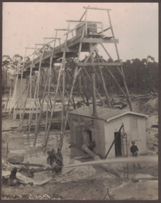
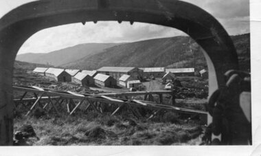
Photograph - Pretty Valley camp including workman's huts, Pretty Valley
At the Pretty Valley Dam site erection of staff quarters was completed in April, 1947 and accommodation for workmen commenced in 1948 but suspended on 11th May for winter and resumed on 9th November. Construction of this camp was completed in 1949. A large dam was proposed at this site but was never constructed. Instead a small diversion dam was built which diverts water either to Rocky Valley Dam or to McKay Creek Power Station.An historical record of the type of accommodation provided for workmen during the construction of the Kiewa Hydro Scheme during the 1940's/50'sBlack and white photograph of Pretty Valley camp showing workman's huts and construction materials.Handwritten on back of photograph in blue pen - Pretty Valleypretty valley, workmen's huts, victorian alps, secv -
 Bendigo Historical Society Inc.
Slide - DAVID MCDONALD COLLECTION: EPPALOCK. CONSTRUCTION, c1963
Eppalock. Construction. David fishing of the bank at Lake Eppalock. Markings: Eppalock Dam near Lyal March 1963 DavidKodakcivil engineering, water supply, eppalock -
 Bendigo Historical Society Inc.
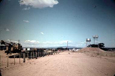
Slide - DAVID MCDONALD COLLECTION: EPPALOCK. CONSTRUCTION, c1961
Eppalock. Construction. Fence line machinery on left side, water tanks on right. Markings: Eppalock Dam Project 1961.Agfacolorcivil engineering, water supply, eppalock -
Tatura Irrigation & Wartime Camps Museum
Book, Lake Eildon - A Record low, 2000
To record and compare water levels and to showcase the success of "Eildon Lake Charters" in Murrindindi Tourism Competition "Best New Business 2000". Book includes many old historic preflooding photos.Clear plastic dust cover. White front cover with photograph of Eildon and Sugarloaf Dam in foreground. Insert of charter boat.buesiness, flooding, boat club, books, history, local -
 Wodonga & District Historical Society Inc
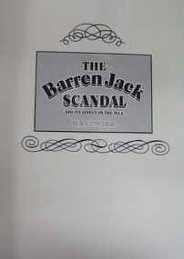
Book - The Barren Jack Scandal and its Effects on the M.I.A, W. R. Cowper, 1987
This book outlines the issues and controversy around the construction of the Barren Jack (Burrinjuck) Water Supply Dam as part of the infrastructure of the Murrumbidgee Irrigation Authority (M.I.A) and its subsequent abandonment. It has now fallen into disrepair,non-fictionThis book outlines the issues and controversy around the construction of the Barren Jack (Burrinjuck) Water Supply Dam as part of the infrastructure of the Murrumbidgee Irrigation Authority (M.I.A) and its subsequent abandonment. It has now fallen into disrepair,irrigation -- government policy, murrumbidgee irrigation area (n.s.w.) -- history, barren jack dam, burrinjuck, yass valley