Showing 640 items
matching footpaths
-
 Eltham District Historical Society Inc
Photograph, Beard Street, Eltham, 3 Sep 1981
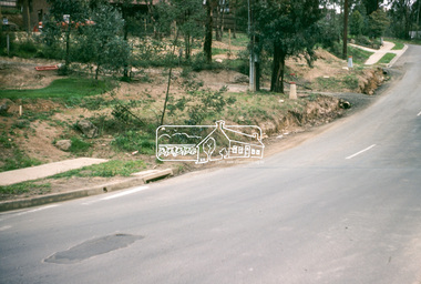
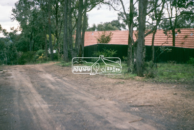
Roll of film taken by Eltham Shire Council officers of roads and houses in the Eltham East area, 3 September 1981 prior to construction of new water main; including views of existing damage to footpaths and gutters and general views of Beard Street. These images provide a perspective of housing estate developments and changes in housing styles and road development which began sweeping in from the mid 1970s with increasing urbanisation of what was once more outlying suburbs and regions.35mm colour positive transparency (1 of 28) Mount - Kodak Kodachrome Cardeltham, infrastructure, roads, beard street -
 Eltham District Historical Society Inc
Photograph, Water Main Pipe Track (Madine Way-Bainbridge Drive), Eltham, 3 Sep 1981
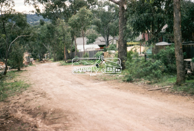
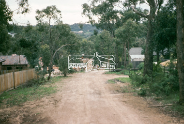
Roll of film taken by Eltham Shire Council officers of roads and houses in the Eltham East area, 3 September 1981 prior to construction of new water main; including views of existing damage to footpaths and gutters and general views of Beard Street. These images provide a perspective of housing estate developments and changes in housing styles and road development which began sweeping in from the mid 1970s with increasing urbanisation of what was once more outlying suburbs and regions.35mm colour positive transparency (1 of 28) Mount - Kodak Kodachrome Cardeltham, infrastructure, roads, bainbridge drive linear reserve, madine way, water main pipe track -
 Eltham District Historical Society Inc
Photograph, Water Main Pipe Track (Madine Way-Bainbridge Drive), Eltham, 3 Sep 1981
Roll of film taken by Eltham Shire Council officers of roads and houses in the Eltham East area, 3 September 1981 prior to construction of new water main; including views of existing damage to footpaths and gutters and general views of Beard Street. These images provide a perspective of housing estate developments and changes in housing styles and road development which began sweeping in from the mid 1970s with increasing urbanisation of what was once more outlying suburbs and regions.35mm colour positive transparency (1 of 28) Mount - Kodak Kodachrome Cardeltham, infrastructure, roads, bainbridge drive linear reserve, madine way, water main pipe track -
 Eltham District Historical Society Inc
Photograph, Water Main Pipe Track (Madine Way-Eucalyptus Road), Eltham, 3 Sep 1981
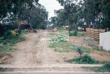
Roll of film taken by Eltham Shire Council officers of roads and houses in the Eltham East area, 3 September 1981 prior to construction of new water main; including views of existing damage to footpaths and gutters and general views of Beard Street. These images provide a perspective of housing estate developments and changes in housing styles and road development which began sweeping in from the mid 1970s with increasing urbanisation of what was once more outlying suburbs and regions.35mm colour positive transparency (1 of 28) Mount - Kodak Kodachrome Cardeltham, infrastructure, roads, water main pipe track, madine way, eucalyptus road, tadema park -
 Eltham District Historical Society Inc
Photograph, Water Main Pipe Track (Madine Way-Eucalyptus Road), Eltham, 3 Sep 1981
Roll of film taken by Eltham Shire Council officers of roads and houses in the Eltham East area, 3 September 1981 prior to construction of new water main; including views of existing damage to footpaths and gutters and general views of Beard Street. These images provide a perspective of housing estate developments and changes in housing styles and road development which began sweeping in from the mid 1970s with increasing urbanisation of what was once more outlying suburbs and regions.35mm colour positive transparency (1 of 28) Mount - Kodak Kodachrome Cardeltham, infrastructure, roads, water main pipe track, madine way, eucalyptus road, tadema park -
 Bendigo Military Museum
Postcard - POSTCARDS, PHOTOGRAPHIC, VARIOUS U.K, c. WW1
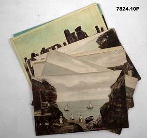
Postcards collected by R.H. Baron while on leave in England during WW1. Part of the "Robert H. Baron" (No. 3596) and Cooper Collections. See Catalogue No. 1981P for details of Baron's service. 1. Coloured coastal scene featuring yachts, beach goers and cliffs. People are standing on a pebbled beach. 2. Coloured coastal scene featuring cliffs and ocean. 3. Coloured coastal scene featuring beach, bathing machines, cliffs and town buildings. 4. Coloured coastal scene featuring beach with boats and town buildings. 5. Sepia toned photograph featuring houses. Stream running in front of house. Footpath between stream and house. 6. Coloured street scene featuring houses fronting a gravel road. 7. Black and white photograph of a street scene featuring buildings, pedestrians and horse drawn transport. 8. Sepia toned photograph of a street scene. Right side lined with houses. Single pedestrian on footpath. 9. Coloured scene featuring standing stones. 10. Coloured photograph of a ruined building overgrown with vegetation.1. Ladram Bay. 2. Ladram Bay. 3. Budleigh Salterton from East. 4. Budleigh Salterton from West. 5. Budleigh Salterton, Cottages at the Granery, 6. Budleigh Salterton, West Terrace. 7. High St. Budleigh Salterton. 8. Budleigh Salterton, Station Road. 9. Stonehenge. 10. Abbey Ruins, Waverley. robert h. baron, cooper collection, postcards, ww1 -
 Bendigo Historical Society Inc.
Photograph - TEMPERANCE HALL, VIEW ST
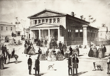
Black and white photograph . Enlargement of illustration of original Temperance Hall, View St. Building with four column portico. Groups of people gathered in foreground (street and footpath) and LHS mid-ground (spare block). History of object: James Lerk March, 2000. Illustration of the Bendigo Temperance Hall designed' in 1860 by Vahland and Getzschmann. The Warden's Court is on the left. This section (minus the portico) is still in situ'.buildings, temperance hall -
 Bendigo Historical Society Inc.
Photograph - TEMPERANCE HALL, VIEW STREET
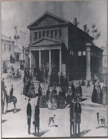
Black and white photograph . Enlargement of illustration of original Temperance Hall, View St. Building with four column portico. Groups of people gathered in foreground (street and footpath) and LHS mid-ground (spare block). History of object: James Lerk March, 2000. Illustration of the Bendigo Temperance Hall designed' in 1860 by Vahland and Getzschmann. The Warden's Court is on the left. This section (minus the portico) is still in situ'.buildings, organisation, temperance hall -
 Bendigo Historical Society Inc.
Document - BILL ASHMAN COLLECTION: CORRESPONDENCE
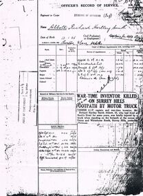
Photocopy of a page from Officer's Record Service of Richard Hartley Smith Abbott. Date stamp at top left 23 May 1939. Paper shows Units where he served. A newspaper clipping has been copied onto the paper headed War-Time Inventor Killed on Surrey Hills Footpath by Motor Truck. Written between headline Sun 26-2-40.sciences, instruments - general, scalebuoy, bill ashman collection - correspondence, richard hartley smith abbott, scott's hotel, 8 air, 67th infy, 5/7th infy, r of o 3rd m.d -
 Bendigo Historical Society Inc.
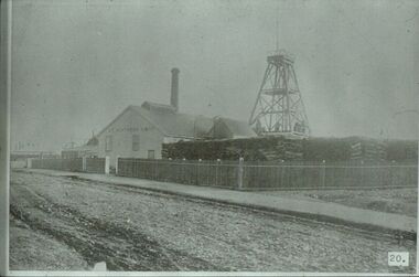
Slide - ALBERT RICHARDSON COLLECTION: GREAT NORTHERN GOLD MINING CO., MARKET STREET, EAGLEHAWK
Slide. Great Northern Gold Mining Co. situated at Market Street, Eaglehawk. Poppet head, chimney, large stacks of wood in foreground. Engine room building has 'Gt. Northern GMC' printed on side. Mine frontgs onto footpath, roadway in front. Neat wooden fence surrounds front of mine buildings. Image taken from 'Healthy Golden Bendigo' book.No. 20 printed on bottom of slide.mine, gold, great northern., bendigo mines-jack hattam collection -
 Whitehorse Historical Society Inc.
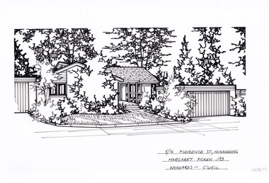
Artwork, other - Ink Line Drawing, Margaret Picken, 5/16 Florence St., Nunawading, 1993
A property illustration by Margaret Picken Commissioned by a real estate agency for the purpose of advertising 5/16 Florence St., Nunawading Made by using Rotring ‘Rapidigraph’ drafting pens with Rotring ink on Rapidigraph polyester drafting film, double matte. Trained as a cartographic draftsman within the mining industry, Margaret Picken is an artist who worked producing property illustrations for real estate agencies in eastern suburbs of Victoria from 1983-2005. Retiring from the industry as technological changes favored coloured photography over illustrations, and commissioning companies over sole contractors.This artwork is of Historical Significance as a record of local domestic architecture.A black ink line drawing on drafters film by Margaret Picken, of a black and white line drawing of a single story brick house with a path leading to the front door, from the public footpath. To the right is the separate garage. Trees and shrubs grow in garden beds in front of the buildings and in the background, while in front of the house is a front lawn. There are two holepunch holes centred just under the upper edge.5/16 Florence St., Nunawading Margaret Picken - 93 Woodards - C'wellwhitehorse historical society, schwerkolt cottage, housing, architecture, margaret picken, house, garden, real estate, nunawading -
 Whitehorse Historical Society Inc.
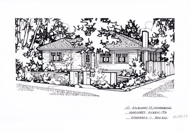
Artwork, other - Ink Line Drawing, Margaret Picken, 10 Holberry St., Nunawading, 1992
A property illustration by Margaret Picken Commissioned by a real estate agency for the purpose of advertising 10 Holberry St., Nunawading. This property is listed as having sold for $139,000 in 1992 Made by using Rotring ‘Rapidigraph’ drafting pens with Rotring ink on Rapidigraph polyester drafting film, double matte. Trained as a cartographic draftsman within the mining industry, Margaret Picken is an artist who worked producing property illustrations for real estate agencies in eastern suburbs of Victoria from 1983-2005. Retiring from the industry as technological changes favored coloured photography over illustrations, and commissioning companies over sole contractors.This artwork is of Historical Significance as a record of local domestic architecture.A black ink line drawing on drafters film by Margaret Picken, of a black and white line drawing of a right hand side corner block single story weatherboard house with a footpath from the corner leading to the front door. At the start of the path are two pillars, one serving as a letterbox. The front yard is edged with garden beds. There are two hole punch holes on just under the upper edge.10 Holberry St., Nunawading Margaret Picken - 92 Woodards - Boxhillwhitehorse historical society, schwerkolt cottage, housing, architecture, margaret picken, house, garden, real estate, nunawading -
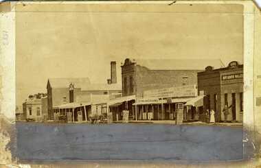 Charlton Golden Grains Museum Inc
Photograph, Procter, Chris, Charlton High Street c.1883, c.1883
Photograph of western end of High Street, Charlton showing the Bank of Victoria, Malcolm's Flour Mill, Egan's, Golden Fleece Hotel, Johnson's Bridge Store, Dining Rooms and the Bank of New South Wales. c. 1883Early photo of High St, western end streetscapeSepia photograph of western end of High Street, Charlton showing the Bank of Victoria, Malcolm's Flour Mill, Egan's, Golden Fleece Hotel, Johnson's Bridge Store, Dining Rooms and the Bank of New South Wales. c. 1883. Man standing in front of the Bank, two ladies also standing on the footpath. Horse and cart in front of Johnson's store. Damage to the lower third of photo.bank of victoria, malcolm's flour mill, egan's, golden fleece hotel, johnson's bridge store, dining rooms, bank of new south wales, high street, business -
 Whitehorse Historical Society Inc.
Map, Proposed shared path network, 2001
... Footpaths ...Draft plans of proposed shared path networkDraft plans of proposed shared path network for Eastern Freeway Extension, Springvale Road to Ringwood.Draft plans of proposed shared path network plans, eastern freeway extension, city of whitehorse, vicroads, city of maroondah, vicroads bicycle coordinator, footpaths, bicycle paths -
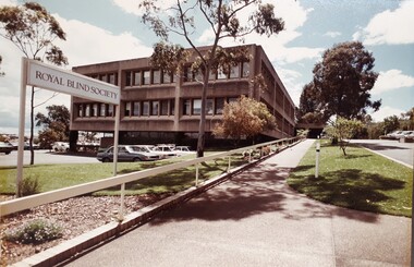 Vision Australia
Photograph - Image, Royal Blind Society of New South Wales in Enfield
Colour photograph taken of the Royal Blind Society of New South Wales building in Enfield, as viewed from Mitchell Street. The two storey building has a car park underneath, with a separate external car park in the front of the building and a sloping driveway and footpath up to the covered entrance. To the right of the driveway is a short term visitors park. Gum trees are planted amongst a well kept lawn. Image was taken around the later 1970s-mid 1980s. A "Royal Blind Society' sign points up the driveway.Digital Image of Enfield building taken from Mitchell Streetroyal blind society of new south wales, buildings -
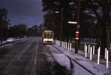 Ballarat Tramway Museum
Slide - Set of 6, Warren Doubleday, Ballarat - last weekday of full operations, 20/8/1971
Photos taken on the last weekday of full operations by the SECV in Ballarat prior to the first closure of the Victoria St line on 22/8/1971. 1 - tram 31 Wendouree Parade near Depot Junction, on its way to Victoria St. 2 - trams 12 and 31 at Haddon St loop 3 - tram 31 in deep hail. 4 - Scrubber at the depot 5 - tram 41 at depot junction, Gardens via Drummond St Nth. Hail blankets the footpath and track. 6 - ditto - Yields information about the last full week day of SEC Tramway operations in Ballarat and has a strong association with the archivist. Set of 7 Kodachrome colour slides - cardboard mountsHave the photographer's slide numbers written on them.trams, tramways, closure, depot, wendouree parade, tram 31, tram 12, scrubber, tram 41 -
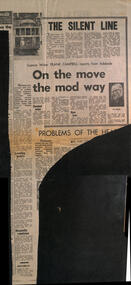 Melbourne Tram Museum
Newspaper, Herald Sun, "The Silent Line", 18-8-1969
Reports on a Science Congress in Adelaide and a speech by Robert Risson about future transport possible systems - all types such as conveyor belts, air cushion vehicles, magnetic cushions, pneumatic tubes, moving footpaths, jet-propelled vehicles, gas turbine and diesel electric buses. These are known as "gadgetbahns" mooted proposals that seldom come to commercial fruition. His main emphasis was on the future all-electric tram fleet that was proposed for Melbourne. Also notes underground systems such as San Francisco. Item by Science Writer Frank Campbell.Yields information about possible future transport systems - gadgetbahnsNewspaper clipping - "The Silent line" and "On the move the mod way" - The Herald "18-8-1969" tramways, trams, melbourne, public transport, future transport, transport systems, electric trams, all-electric trams, robert risson, gadgetbahns, underground tramways -
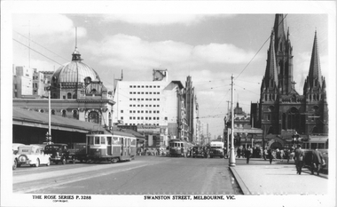 Melbourne Tram Museum
Postcard, Rose Stereograph Co, "Swanston Street Melbourne", early 1940s
Rose Series postcard No. P 3288 titled "Swanston Street Melbourne", looking north from just past (or south) of Batman Ave. There are five trams in the view and one private Reo bus. W2 class tram 452 (route 64 - City). The trams have a white strip under the driver's windows indicating the war time black out measure. The sign board advertising tram routes to Wattle Park, Burwood etc can be seen above the footpath leading to Batman Ave.Yields information about Swanston St. at the intersection with Batman Ave.Postcard - printed real photograph with Rose Stereograph Co. name on the rear.Has "K J Magor" stamp on rear.trams, tramways, w2 class, swanston st, bus, batman ave, tram 452, route 64, world war ii -
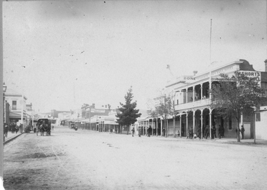 Stawell Historical Society Inc
Photograph, Main Street Stawell looking East with the Town Hall Hotel on the right c1890
Main street scene, Town Hall Hotel on the right. Horse drawn vehicle on left in the street. People standing under verandah on footpath. Showing W. Shorts Hotel also known as the Town Hall Hotel. Looking East up Main Street. Visible Post Office Hotel, Spragues Sporting Depot. Town Hall Hotel was erected in 1873 by W Candy the owner and holder of the first license. Some of the early licensees were W.H. Richards, Davies, W. Short & Hugh Menzies.Sepia photograph of a scene of Main St Stawell. Town Hall Hotel on the right. Horse drawn vehicle on left in the street. People standing under veranda in foot path. Trees in Street.Miss E. Moulden 54 Dawson St Stawell stawell shops businesses streetscape -
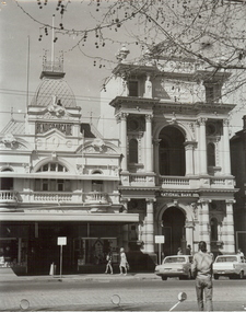 Bendigo Historical Society Inc.
Photograph - BENDIGO ARCADE, 1970's ?
black and white photograph,. Entrance from Pall Mall of 'Bendigo Arcade' and former Colonial Bank, later National Bank ( J. Lerk, 10th. March, 2000 ) National Bank, sign over entrance, finials to pressed steel roof. Moulding decorates upper storey windows and balcony. National bank with cast urns to roof. Valiant sedan car on left. Holden on right. Parking meters on footpath.organization, business, bendigo arcade -
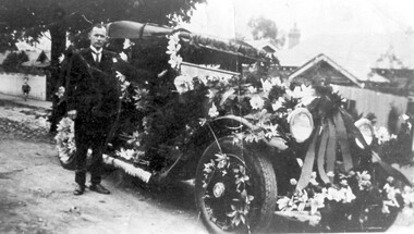 Surrey Hills Historical Society Collection
Photograph, Fred Lyons' taxi decorated for celebrations for Empire Day in 1930s, 1933-1938
This is one of a series of photos donated by Arthur Lyons. From 1907 a cab service operated from near the railway gates in Union Road. It was established and maintained by Mr C Fraser until c1916. George Rea either took over then or set up in opposition. Fred Lyons initially worked for George until he set up his own business. In time he changed over to a motor vehicle and continued his service until 1960. Frederick Adolphus Lyons (1891-1980) was born in Surrey Hills, son of Thomas and Catherine Lyons. He married Elizabeth Ruby Hall in 1918. They lived just around the corner at 55 Sunbury Crescent. The Lyons’ home in Sunbury Crescent was called ‘Knopshambury’ - this was probably a misspelling of Knockshanbally in Co Kilkenny, the birth place of Fred’s father, Thomas Edmund Josias Lyons (1846-1915). Arthur Lyons was born in Surrey Hills on 12 Jun 1920. He became a motor mechanic / welder and lived at 55 Sunbury Crescent. The donation was made while he was in hospital. He died shortly afterwards (23 Sep 1990). Donation was finalised by a neighbour, Mrs Florence Ann Armitstead, wife of Glen Victor Armitstead. Glen was a local hairdresser. They moved to 11 Sunbury Crescent after their marriage in 1939. Arthur had no relatives to distribute the material to. Empire Day celebrations were held in Surrey Hills from 1906-1911; they were revived between 1933-1938 by the Surrey Hills Progress Association. They featured street parades with highly decorated vehicles provided by local businesses and bonfires, including the one in Beckett Park.Black and white photo of Mr Fred Lyons with his taxi decorated for Empire Day. The tourer car is parked in the street and is festooned with flowers and ribbons on the hood, bonnet radiator, running board and in the tyre spokes. Mr Lyons stands by the driver's side door. He is wearing a suit with a winged collar and tie. A small child is watching from the footpath on the left just behind a mature tree. There are houses in the background. empire day, motor vehicles, festivals and celebrations, taxis, fred lyons, frederick adolphus lyons -
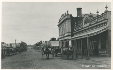 Kilmore Historical Society
Photograph, Sydney Street Looking South, 1912
12.5cm x 20cm black and white photograph looking south on Sydney Street. Can be seen is original building which are now demolished. Also can be seen is: Morrissey Butchers, J.Loft Railway Hotel, Bullivant, some unidentified building and the Red Lion Hotel. Also in the picture are horse drawn vehicles and people walking on the footpaths, and power poles. One copy of the image is mounted on archival board.Written on the back of the mounting: 104/1.22 20486/1-22 Looking South Sydney St Kilmore Shops now demolished on left From right Morrissey Butchers, J. Loft Railway Hotel, Bullivant ?, ?, ?, Red Lion Hotel. R.J. Fagg. 17 Link Avenue, Kilmore 3601 Written on the back of one copy: 104/1.22 22 200486/1 22 P.C. Sydney Str. looking south 1912 Kilmore Historical Societyshopfronts, storefronts, retail stores -
 Melbourne Tram Museum
Negative, Wal Jack collection, c1930
Black and white negative from Wal Jack collection of the Elizabeth St terminus with W2 607 in the shunt, route 50, to North Melbourne while another W2 waits. A man with large sack over his shoulder is walking to the footpath. In the background is the Flinders St Station with a sign advertising Sunday excursion fares. Photo c1930. Photo may not be by Wal Jack as a size that he did not use.trams, tramways, elizabeth st, flinders st station, route 50, w2 class, tram 607 -
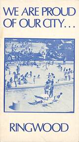 Ringwood and District Historical Society
Pamphlet, We Are Proud of Our City - Ringwood (1973), 1973
Community information brochure issued in 1973 by Ringwood Council outlining local services, sporting, and cultural facilities. Includes names of Ward Councillors, and two City of Ringwood Free Tipping Vouchers valid until the end of 1974."Frontpiece: A quiet corner of the Fred Dwerryhouse Swimming Centre, Jubilee Park." "The staff at the Civic Centre are at your service. Ring 8704311 for guidance on - Town Planning applications, Road and footpath construction, Building matters, Garbage clearance, Connection to sewer by end of 1973, Immunisation times and places, Home help, Rate payments and valuations, Booking of meeting rooms, Clearance of fire hazards, Stray dogs and all nuisance complaints."rinx -
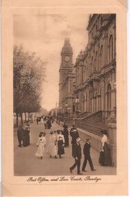 Bendigo Historical Society Inc.
Postcard - CARWARDINE COLLECTION: POST OFFICE AND LAW COURTS BENDIGO, 1800/1900
Sepia colour postcard, portrait style Written on bottom 'Post Office, and Law Courts, Bendigo'. Image shows many people walking down Pall Mall on footpath outside Law Courts and Post Office. Women wearing ankle length dresses, large 'picture' hats. Men suits, straw boaters. Clothing appears to date to 1800's to early 1900's. Receipt number 355/16Printed in Saxony, on back of cardbendigo, business, carwardine soap and candle