Showing 375 items
matching horse trainer
-
 Victorian Harness Racing Heritage Collection at Lord's Raceway Bendigo
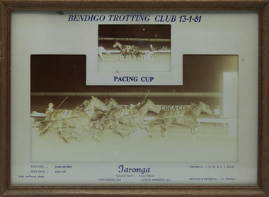
Photograph - Framed photo finish, Greg Matthews Photo, Taronga, 13 January 1981
Taronga won the Bendigo Pacing Cup on the 13 January 1981, followed by High Moore and Justin Hanover. Taronga owned by BW & VJ Ellis, was trained and driven by C Powell. Taronga raced from 1976 (3yo) through to 1981 (8yo). Career: 22 wins 15 seconds 20 thirds 138 starts.Two colour photographs, one small one large in a brown frame. At the top: Bendigo Trotting Club 13-1-81/ Pacing Cup At the bottom: Left corner: Distance 2300 metres/ Mile rate 2.03-1/5 / Greg Matthews Photo Centre: Taronga (General Scott - Avian Debra) / High Moore 2nd / Justin Hanover 3rd Right corner: Owned by- BW & VJ Ellis/ Trained and driven by - C Powellbendigo harness racing club, horses, race, winner, bendigo trotting club, pacing cup, driver, trainer, owner, 1981, taronga, c powell, bw & vj ellis, high moore, justin hanover, cliff powell, ch powell -
 Victorian Harness Racing Heritage Collection at Lord's Raceway Bendigo
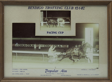
Photograph - Framed photo finish, Greg Matthews Photo, Popular Alm, 12 January 1982
Popular Alm won the Bendigo Pacing Cup on the 12 January 1982, followed by William Boyd and Master Kane. Popular Alm owned by Sun Group, was trained and driven by RV Knight. Popular Alm raced from 1979 (2yo) through to 1985 (8yo). Career: 49 wins 7 seconds 3 thirds 62 starts. Refer to Identifier 15.24 (Media) for Full Career Performance Record.Two colour photographs, one small one large in a brown frame. At the top: Bendigo Trotting Club 12-1-82/ Pacing Cup At the bottom: Left corner: Distance 2700 metres/ Mile rate 2.06-1/5 / Greg Matthews Photo - Stawell Centre: Popular Alm (Sovereign Adios - Direct Design) / William Boyd 2nd / Master Kane 3rd Right corner: Owned by- Sun Group/ Trained and driven by - RV Knightbendigo harness racing club, horses, race, winner, bendigo trotting club, pacing cup, driver, trainer, owner, 1982, popular alm, rv knight, sun group, william boyd, master kane, bob knight, vj knight, vin knight -
 Victorian Harness Racing Heritage Collection at Lord's Raceway Bendigo
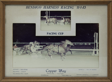
Photograph - Framed photo finish, Greg Matthews Photo, Copper Way, 11 January 1983
Copper Way won the Bendigo Pacing Cup on the 11 January 1983, followed by Doubter and Thor Lobell. Copper Way owned by Mr KM Madden, was trained and driven by TE Demmler. Copper Way raced from 1980 (3yo) through to 1984 (7yo). Career: 25 wins 18 seconds 1 third 65 starts.Two colour photographs, one small one large in a brown frame. At the top: Bendigo Harness Racing 11-1-83/ Pacing Cup At the bottom: Left corner: Distance 2300 metres/ Mile rate 2.02-2/5 / Greg Matthews Photo - Stawell Centre: Copper Way (Hilarious Way - Unreal Flight) / Doubter 2nd / Thor Lobell 3rd Right corner: Owned by- Mr KM Madden/ Trained and driven by - TE Demmlerbendigo harness racing club, horses, race, winner, bendigo trotting club, pacing cup, driver, trainer, owner, 1983, copper way, te demmler, mr km madden, doubter, thor lobell, ted demmler, t demmler -
 Victorian Harness Racing Heritage Collection at Lord's Raceway Bendigo
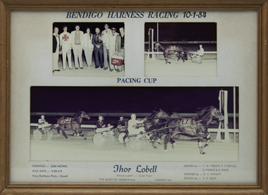
Photograph - Framed photo finish, Greg Matthews Photo, Thor Lobell, 10 January 1984
Thor Lobell won the Bendigo Pacing Cup on the 10 January 1984, followed by The Guest of Honour and Lassken. Thor Lobell owned by TM Hogan, KF Grivec, G Pardo & S Dove, was trained by RV Knight and driven by SD Dove. Thor Lobell raced from 1980 (2yo) through to 1988 (10yo). Career: 36 wins 17 seconds 16 thirds 114 starts.Three colour photographs, two small one large in a brown frame. At the top: Bendigo Harness Racing 10-1-84/ Pacing Cup At the bottom: Left corner: Distance 2300 metres/ Mile rate 2.03-3/5 / Greg Matthews Photo - Stawell Centre: Thor Lobell (Encore Lobell - Coral Thor) / The Guest of Honour 2nd / Lassken 3rd Right corner: Owned by- TM Hogan, KF Grivec, G Pardo & S Dove/ Trained by RV Knight/ Driven by - SD Dovebendigo harness racing club, horses, race, winner, bendigo trotting club, pacing cup, driver, trainer, owner, thor lobell, 1984, rv knight, sd dove, tm hogan, kf grivec, g pardo, s dove, the guest of honour, lassken, bob knight, vj knight, vin knight, stephen dove -
 Victorian Harness Racing Heritage Collection at Lord's Raceway Bendigo
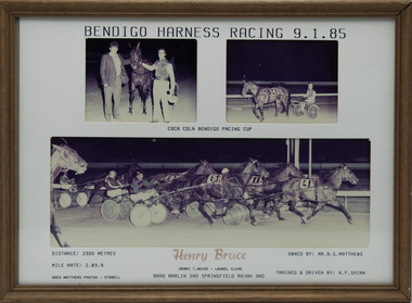
Photograph - Framed photo finish, Greg Matthews Photo, Henry Bruce, 9 January 1985
Henry Bruce won the Bendigo Pacing Cup on the 9 January 1985, followed by Brad Marlin and Springfield Rajah. Henry Bruce owned by Mr BG Matthews, was trained and driven by NF Shinn. Henry Bruce raced from 1981 (2yo) through to 1987 (8yo). Career: 21 wins 17 seconds 21 thirds 175 starts.Three colour photographs, two small one large in a brown frame. At the top: Bendigo Harness Racing 9-1-85/ Coca Cola Bendigo Pacing Cup At the bottom: Left corner: Distance 2300 metres/ Mile rate 2.03.8 / Greg Matthews Photos - Stawell Centre: Henry Bruce (Henry T Adios - Laurel Cleve) / Brad Marlin 2nd / Springfield Rajah 3rd Right corner: Owned by- Mr BG Matthews/ Trained and driven by - NF Shinnbendigo harness racing club, horses, race, winner, bendigo trotting club, pacing cup, driver, trainer, owner, 1985, henry bruce, nf shinn, mr bg matthews, brad marlin, springfield rajah, noel shinn -
 Victorian Harness Racing Heritage Collection at Lord's Raceway Bendigo
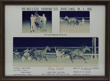
Photograph - Framed photo finish, Greg Matthews Photo, Bag Limit, 8 January 1986
Bag Limit won the Bendigo Pacing Cup on the 8 January 1986, followed by Quite Famous and Times Run Out. Bag Limit owned by ML Falls, AM Osborne, P & WM Day, was trained by RV Knight and driven by Vin Knight. Bag Limit raced from 1985 (3yo) through to 1990 (8yo). Career: 35 wins 16 seconds 5 thirds 71 starts.Three colour photographs, two small one large in a brown frame. At the top: Bendigo Harness Racing 8-1-86/ Coca Cola Bendigo Pacing Cup At the bottom: Left corner: Distance 2300 metres/ Mile rate 2.02.8/ Track Record / Greg Matthews Photos - Stawell Centre: Bag Limit (Tarport Skipper - Royal Blend) / Quite Famous 2nd / Times Run Out 3rd Right corner: Owned by- ML Falls, AM Osborne, P & WM Day/ Trained by RV Knight / Driven by Vin Knightbendigo harness racing club, horses, race, winner, bendigo trotting club, pacing cup, driver, trainer, owner, 1986, bag limit, rv knight, vin knight, ml falls, am osborne, p & wm day, quite famous, times run out, vj knight, bob knight -
 Victorian Harness Racing Heritage Collection at Lord's Raceway Bendigo
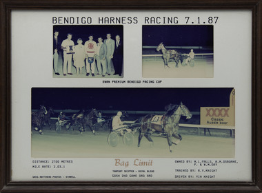
Photograph - Framed photo finish, Greg Matthews Photo, Bag Limit, 7 January 1987
Bag Limit won the Bendigo Pacing Cup on the 7 January 1987, followed by Gosh and Game Oro. Bag Limit owned by ML Falls, AM Osborne, P & WM Day, was trained by RV Knight and driven by Vin Knight. Bag Limit raced from 1985 (3yo) through to 1990 (8yo). Career: 35 wins 16 seconds 5 thirds 71 starts.Three colour photographs, two small one large in a brown frame. At the top: Bendigo Harness Racing 7-1-87/ Swan Premium Bendigo Pacing Cup At the bottom: Left corner: Distance 2700 metres/ Mile rate 2.03.1/ Greg Matthews Photos - Stawell Centre: Bag Limit (Tarport Skipper - Royal Blend) / Gosh 2nd / Game Oro 3rd Right corner: Owned by- ML Falls, AM Osborne, P & WM Day/ Trained by RV Knight / Driven by Vin Knightbendigo harness racing club, horses, race, winner, bendigo trotting club, pacing cup, driver, trainer, owner, bag limit, rv knight, vin knight, ml falls, am osborne, p & wm day, 1987, gosh, game oro, vj knight, bob knight -
 Victorian Harness Racing Heritage Collection at Lord's Raceway Bendigo
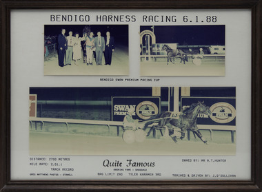
Photograph - Framed photo finish, Greg Matthews Photo, Quite Famous, 6 January 1988
Quite Famous won the Bendigo Pacing Cup on the 6 January 1988, followed by Bag Limit and Tyler Karamea. Quite Famous owned by Mr AT Hunter, was trained and driven by J O'Sullivan. Quite Famous raced from 1983 (2yo) through to 1990 (9yo). Career: 45 wins 24 seconds 25 thirds 181 starts.Three colour photographs, two small one large in a brown frame. At the top: Bendigo Harness Racing 6-1-88/ Bendigo Swan Premium Pacing Cup At the bottom: Left corner: Distance 2700 metres/ Mile rate 2.01.1/ Track Record/ Greg Matthews Photos - Stawell Centre: Quite Famous (Knowing Fame - Shooshla) / Bag Limit 2nd / Tyler Karamea 3rd Right corner: Owned by- Mr AT Hunter/ Trained and driven by J O'Sullivanbendigo harness racing club, horses, race, winner, bendigo trotting club, pacing cup, driver, trainer, owner, 1988, quite famous, j o'sullivan, mr at hunter, bag limit, tyler karamea, jim o'sullivan -
 Victorian Harness Racing Heritage Collection at Lord's Raceway Bendigo
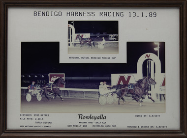
Photograph - Framed photo finish, Greg Matthews Photo, Rowleyalla, 13 January 1989
Rowleyalla won the Bendigo Pacing Cup on the 13 January 1989, followed by Sir Reilly and Riverlea Jack. Rowleyalla owned by K Rivett, was trained and driven by K Rivett. Rowleyalla raced from 1987 (2yo) through to 1992 (7yo). Career: 38 wins 19 seconds 13 thirds 110 starts.Two colour photographs, one small one large in a brown frame. At the top: Bendigo Harness Racing 13-1-89/ National Mutual Bendigo Pacing Cup At the bottom: Left corner: Distance 2700 metres/ Mile rate 2.00.5 /Track Record / Greg Matthews Photos - Stawell Centre: Rowleyalla (National Byrd - Sally Alla) / Sir Reilly 2nd / Riverlea Jack 3rd Right corner: Owned by- K Rivett/ Trained and driven by K Rivettbendigo harness racing club, horses, race, winner, bendigo trotting club, pacing cup, driver, trainer, owner, 1989, rowleyalla, k rivett, sir reilly, riverlea jack, ken rivett -
 Victorian Harness Racing Heritage Collection at Lord's Raceway Bendigo
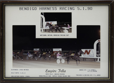
Photograph - Framed photo finish, Greg Matthews Photo, Empire Fella, 5 January 1990
Empire Fella won the Bendigo Pacing Cup on the 5 January 1990, followed by Rowleyalla and Rufus Young Blood. Empire Fella owned by FA Sewell & SS Payne, was trained and driven by PL Ward. Empire Fella raced from 1986 (3yo) through to 1992 (9yo). Career: 35 wins 23 seconds 19 thirds 181 starts.Two colour photographs, one small one large in a brown, black, gold frame. At the top: Bendigo Harness Racing 5-1-90/ National Mutual Bendigo Pacing Cup At the bottom: Left corner: Distance 2700 metres/ Mile rate 2.01.4 / Greg Matthews Photos - Stawell Centre: Empire Fella (Besta Fella - Dancing Princess) / Rowleyalla 2nd / Rufus Young Blood 3rd Right corner: Owned by- FA Sewell & SS Payne/ Trained and driven by PL Wardbendigo harness racing club, horses, race, winner, bendigo trotting club, pacing cup, driver, trainer, owner, 1990, empire fella, fa sewell, ss payne, rowleyalla, rufus young blood, p ward, peter ward -
 Victorian Harness Racing Heritage Collection at Lord's Raceway Bendigo
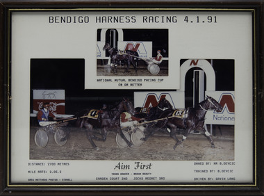
Photograph - Framed photo finish, Greg Matthews Photo, Aim First, 4 January 1991
Aim First won the Bendigo Pacing Cup on the 4 January 1991, followed by Carden Court and Jocks Regret. Aim First owned by Mr B Devcic, was trained by B Devcic and driven by Gavin Lang. Aim First raced from 1986 (2yo) through to 1996 (12yo). Career: 38 wins 34 seconds 34 thirds 229 starts.Two colour photographs, one small one large in a brown, black, gold frame. At the top: Bendigo Harness Racing 4-1-91/ National Mutual Bendigo Pacing Cup/ C8 or better At the bottom: Left corner: Distance 2700 metres/ Mile rate 2.05.2 / Greg Matthews Photos - Stawell Centre: Aim First (Young Dancer - Brahn Beauty) / Carden Court 2nd / Jocks Regret 3rd Right corner: Owned by- Mr B Devcic/ Trained by B Devcic / Driven by Gavin Langbendigo harness racing club, horses, race, winner, bendigo trotting club, pacing cup, driver, trainer, owner, 1991, aim first, b devcic, gavin lang, carden court, jocks regret, boris devcic, g lang -
 Victorian Harness Racing Heritage Collection at Lord's Raceway Bendigo
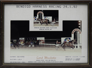
Photograph - Framed photo finish, Greg Matthews Photo, Lord Muckalee, 24 January 1992
Lord Muckalee won the Bendigo Pacing Cup on the 24 January 1992. Awarded First Place after Disqualification of Defoe Lord Muckalee owned by JR & Est GS Monk, was trained and driven by GJ Morgan. Lord Muckalee raced from 1989 (2yo) through to 1995 (8yo). Career: 21 wins 15 seconds 7 thirds 76 starts. Two colour photographs, one small one large in a brown, black, gold frame. At the top: Bendigo Harness Racing 24-1-92/ Bendigo Southern Cross Television Bendigo Pacing Cup At the bottom: Left corner: Distance 2700 metres/ Mile rate 2.03.4 / Greg Matthews Photos - Stawell Centre: Lord Muckalee (Muckalee Strike - Saint Mary Redcliffe) / Awarded First Place after Disqualification of Defoe Right corner: Owned by- JR & Est GS Monk/ Trained and driven by GJ Morganbendigo harness racing club, horses, race, winner, bendigo trotting club, pacing cup, driver, trainer, owner, 1992, lord muckalee, gj morgan, jr & est gs monk, defoe, graeme morgan -
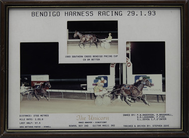 Victorian Harness Racing Heritage Collection at Lord's Raceway Bendigo
Photograph - Framed photo finish, Greg Matthews Photo, The Unicorn, 29 January 1993
The Unicorn won the Bendigo Pacing Cup on the 29 January 1993, followed by Bowral Boy and Guitar Magic. The Unicorn owned by PW Anderson, R Broomhall, KR Loughnan, P Pike, SL Dove & CF O'Dwyer, was trained and driven by Stephen Dove. The Unicorn raced from 1989 (2yo) through to 1995 (8yo). Career: 29 wins 18 seconds 14 thirds 94 starts.Two colour photographs, one small one large in a brown, black, gold frame. At the top: Bendigo Harness Racing 29-1-93/ 1993 Southern Cross Bendigo Pacing Cup / C9 or Better At the bottom: Left corner: Distance 2700 metres/ Mile rate 2.03.6/ Last Half 57.5 / Greg Matthews Photos - Stawell Centre: The Unicorn (Vance Hanover - Significant) / Bowral Boy 2nd / Guitar Magic 3rd Right corner: Owned by- PW Anderson, R Broomhall, KR Loughnan, P Pike, SL Dove & CF O'Dwyer/ Trained and driven by Stephen Dovebendigo harness racing club, horses, race, winner, bendigo trotting club, pacing cup, driver, trainer, owner, 1993, the unicorn, stephen dove, pw anderson, r broomhall, kr loughnan, p pike, sl dove, cf o'dwyer, bowral boy, guitar magic, s dove, carl o'dwyer -
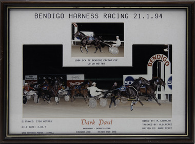 Victorian Harness Racing Heritage Collection at Lord's Raceway Bendigo
Photograph - Framed photo finish, Greg Matthews Photo, Dark Paul, 21 January 1994
Dark Paul won the Bendigo Pacing Cup on the 21 January 1994, followed by Cougar and Aston Bow. Dark Paul owned by MJ Hanlan, was trained by AD Peace and driven by Mark Peace. Dark Paul raced from 1990 (2yo) through to 1995 (7yo). Career: 35 wins 22 seconds 5 thirds 90 starts.Two colour photographs, one small one large in a brown, black, gold frame. At the top: Bendigo Harness Racing 21-1-94/ 1994 SCN TV Bendigo Pacing Cup / C9 or Better At the bottom: Left corner: Distance 2700 metres/ Mile rate 2.03.7 / Greg Matthews Photos - Stawell Centre: Dark Paul (Paulsboro - Intrepid Pearl) / Cougar 2nd / Aston Bow 3rd Right corner: Owned by- MJ Hanlan/ Trained by AD Peace / Driven by Mark Peacebendigo harness racing club, horses, race, winner, bendigo trotting club, pacing cup, driver, trainer, owner, 1994, dark paul, ad peace, mark peace, mj hanlan, cougar, aston bow -
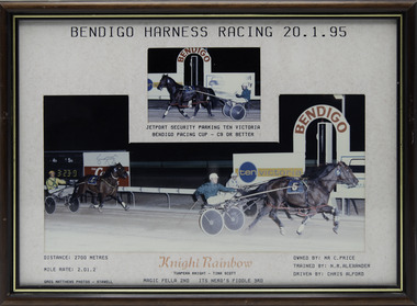 Victorian Harness Racing Heritage Collection at Lord's Raceway Bendigo
Photograph - Framed photo finish, Greg Matthews Photo, Knight Rainbow, 20 January 1995
Knight Rainbow won the Bendigo Pacing Cup on the 20 January 1995, followed by Magic Fella and Its Nero's Fiddle. Knight Rainbow owned by Mr C Price, was trained by NR Alexander and driven by Chris Alford. Knight Rainbow raced from 1992 (2yo) through to 1997 (7yo). Career: 22 wins 8 seconds 8 thirds 85 starts.Two colour photographs, one small one large in a brown, black, gold frame. At the top: Bendigo Harness Racing 20-1-95/ Jetport Security Parking Ten Victoria Bendigo Pacing Cup / C9 or Better At the bottom: Left corner: Distance 2700 metres/ Mile rate 2.01.2 / Greg Matthews Photos - Stawell Centre: Knight Rainbow (Tuapeka Knight - Tina Scott) / Magic Fella 2nd / Its Nero's Fiddle 3rd Right corner: Owned by- Mr C Price/ Trained by NR Alexander / Driven by Chris Alfordbendigo harness racing club, horses, race, winner, bendigo trotting club, pacing cup, driver, trainer, owner, 1995, knight rainbow, nr alexander, chris alford, mr c price, magic fella, its nero's fiddle, ca alford -
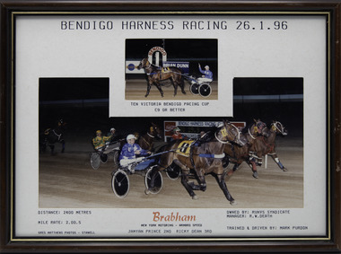 Victorian Harness Racing Heritage Collection at Lord's Raceway Bendigo
Photograph - Framed photo finish, Greg Matthews Photo, Brabham, 26 January 1996
Brabham won the Bendigo Pacing Cup on the 26 January 1996, followed by Jamyan Prince and Ricky Dean. Brabham owned by Runvs Syndicate, Manager RW Death, was trained and driven by Mark Purdon. Brabham raced from 1994 (3yo) through to 2000 (9yo). Career: 20 wins 19 seconds 9 thirds 79 starts.Two colour photographs, one small one large in a brown, black, gold frame. At the top: Bendigo Harness Racing 26-1-96/ Ten Victoria Bendigo Pacing Cup / C9 or Better At the bottom: Left corner: Distance 2400 metres/ Mile rate 2.00.5 / Greg Matthews Photos - Stawell Centre: Brabham (New York Motoring - Armbro Speed) / Jamyan Prince 2nd / Ricky Dean 3rd Right corner: Owned by- Runvs Syndicate - Manager RW Death/ Trained and driven by Mark Purdonbendigo harness racing club, horses, race, winner, bendigo trotting club, pacing cup, driver, trainer, owner, 1996, brabham, mark purdon, runvs syndicate, jamyan prince, ricky dean, m purdon -
 Victorian Harness Racing Heritage Collection at Lord's Raceway Bendigo
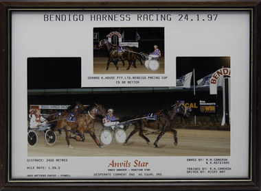
Photograph - Framed photo finish, Greg Matthews Photo, Anvil's Star, 24 January 1997
Anvil's Star won the Bendigo Pacing Cup on the 24 January 1997, followed by Desperate Comment and No Equal. Anvil's Star owned by RM Cameron & K Kotzikas, was trained by RM Cameron and driven by Ricky May. Anvil's Star raced from 1995 (3yo) through to 2001 (9yo). Career: 17 wins 22 seconds 11 thirds 116 starts.Two colour photographs, one small one large in a brown, black, gold frame. At the top: Bendigo Harness Racing 24-1-97/ Gerard K House Pty Ltd Bendigo Pacing Cup / C9 or Better At the bottom: Left corner: Distance 2400 metres/ Mile rate 1.59.3 / Greg Matthews Photos - Stawell Centre: Anvils Star (Vance Hanover - Venetian Star) / Desperate Comment 2nd / No Equal 3rd Right corner: Owned by- RM Cameron & K Kotzikas/ Trained by RM Cameron / Driven by Ricky Maybendigo harness racing club, horses, race, winner, bendigo trotting club, pacing cup, driver, trainer, owner, 1997, anvils star, rm cameron, ricky may, k kotzikas, desperate comment, no equal, robert cameron, r may, r cameron -
 Victorian Harness Racing Heritage Collection at Lord's Raceway Bendigo
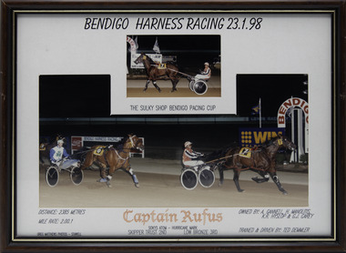
Photograph - Framed photo finish, Greg Matthews Photo, Captain Rufus, 23 January 1998
Captain Rufus won the Bendigo Pacing Cup on the 23 January 1998, followed by Skipper Trust and Low Bronze. Captain Rufus owned by A Gannell, H Manolitis, KR Hyslop & GJ Carey, was trained and driven by Ted Demmler. Captain Rufus raced from 1996 (3yo) through to 2001 (8yo). Career: 17 wins 13 seconds 18 thirds 85 starts.Two colour photographs, one small one large in a brown, black, gold frame. At the top: Bendigo Harness Racing 23-1-98/ The Sulky Shop Bendigo Pacing Cup At the bottom: Left corner: Distance 2385 metres/ Mile rate 2.00.1 / Greg Matthews Photos - Stawell Centre: Captain Rufus (Sokys Atom - Hurricane Mark) / Skipper Trust 2nd / Low Bronze 3rd Right corner: Owned by- A Gannell, H Manolitis, KR Hyslop & GJ Carey/ Trained and driven by Ted Demmlerbendigo harness racing club, horses, race, winner, bendigo trotting club, pacing cup, driver, trainer, owner, 1998, captain rufus, ted demmler, a gannell, h manolitis, kr hyslop, gj carey, skipper trust, low bronze, te demmler, t demmler -
 Victorian Harness Racing Heritage Collection at Lord's Raceway Bendigo
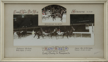
Photograph - Framed photo finish, Maori Miss, 4 May 1963
... owned by Mrs R McD Healy, was trained and driven by G Gath ...Maori Miss won the Linda 2 Year Old Hcp at Melbourne Showgrounds on the 4 May 1963, followed by Lady Chesty and Pampean. Maori Miss owned by Mrs R McD Healy, was trained and driven by G Gath. Maori Miss raced from 1963 (2yo) through to 1967 (6yo). Career: 20 wins 12 seconds 10 thirds 63 starts. Refer to Identifier 15.190 (Media) for Full Career Performance Record.Two colour photographs, one small one large in a white frame. At the top: Linda 2 Year Old Hcp/ Melbourne / 4-5-63 / Returning to Scale At the bottom: Left corner: Distance 9 1/2 furls / Mile rate 2 -14 4/5 Centre: Maori Miss 1st (Grand Monarch - Yendarra) / Lady Chesty 2nd / Pampean 3rd Right corner: Owner Mrs R McD Healy / Trainer - Driver G Gathhorses, race, winner, driver, trainer, owner, 1963, maori miss, melbourne, showgrounds, g gath, mrs r mcd healy, lady chesty, pampean, george gath, r healy, r mcd healy, ric healy -
 Victorian Harness Racing Heritage Collection at Lord's Raceway Bendigo
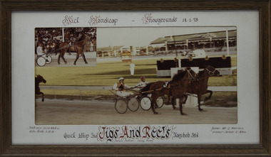
Photograph - Framed photo finish, Jigs And Reels, 14 January 1978
... thirds 216 starts. horses race winner driver trainer owner ...Jigs And Reels won the Kick Handicap at Melbourne Showgrounds on the 14 January 1978, followed by Quick Whip and Kazibob. Jigs And Reels owned by Mr G Harrison, was trained and driven by K Allen. Jigs And Reels raced from 1975 (3yo) through to 1979 then went to US and raced until 1985 (13yo). Career: 29 wins 22 seconds 20 thirds 216 starts.Two colour photographs, one small one large in a brown frame. At the top: Kick Handicap/ Showgrounds / 14-1-78 At the bottom: Left corner: Distance 2538 Metres / Kilo rate 1-22-4 Centre: Quick Whip 2nd /Jigs And Reels (Delvin Dancer - Canny Rose) / Kazibob 3rd Right corner: Owner Mr G Harrison / Trainer - Driver K Allenhorses, race, winner, driver, trainer, owner, melbourne, showgrounds, 1978, jigs and reels, k allen, mr g harrison, quick whip, kazibob -
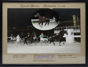 Victorian Harness Racing Heritage Collection at Lord's Raceway Bendigo
Photograph - Framed photo finish, Lynmont, 16 November 1968
... . horses race winner driver trainer owner melbourne showgrounds ...Lynmont won the Lansell Stakes at Melbourne Showgrounds on the 16 November 1968, followed by Adios Green and Timothy Scott. Lynmont owned by Mrs C Inglis, was trained and driven by KW Wills. Two colour photographs, one small one large in a black frame. At the top: Lansell Stakes/ Melbourne / 16-11-68 At the bottom: Left corner: Distance 12 1/2 furls / Mile rate 2 -8 2/5 Centre: Lynmont 1st (Gay Reveller - Free Lass) / Adios Green 2nd / Timothy Scott 3rd Right corner: Owner Mrs C Inglis / Trainer - Driver KW Willshorses, race, winner, driver, trainer, owner, melbourne, showgrounds, 1968, lynmont, kw wills, mrs c inglis, adios green, timothy scott, ken wills -
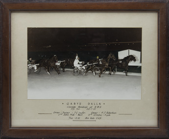 Victorian Harness Racing Heritage Collection at Lord's Raceway Bendigo
Photograph - Framed photo finish, Gaby's Dalla, 20 January 1951
... . horses race winner driver trainer owner melbourne showgrounds ...Gaby's Dalla won the Cooinda Handicap at Melbourne Showgrounds on the 20 January 1951, followed by John's Pride and Glimpse. Gaby's Dalla owned by HJ Robertson, was trained and driven by TC Taylor. One large colour photograph in a brown frame. At the top: Gaby's Dalla / Cooinda Handicap at RMS / 12 1/2 Fur / 20-1-51 In the middle: Left side: Driver - Trainer TC Taylor / 2nd John's Pride - Neck Right side: Owner HJ Robertson / 3rd Glimpse - 4 yds At the bottom: Time - 3.32 / Mile Rate 2-15 1/5horses, race, winner, driver, trainer, owner, melbourne, showgrounds, 1951, gaby's dalla, tc taylor, hj robertson, john's pride, glimpse -
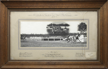 Victorian Harness Racing Heritage Collection at Lord's Raceway Bendigo
Photograph - Wooden framed photo finish, Akers & Co, Cooraminta, 26 August 1937
Cooraminta won the Distance Handicap Trot Bendigo on the 26 August 1937, followed by Phar Patrol and The Gap. Cooraminta owned by Mr J Lewis, was trained and driven by C Robertson Jun. Two colour photographs, one small one large in a brown frame. At the top: Distance Handicap Trot Bendigo / 26-8-37 At the bottom: Left corner: Owner Mr J Lewis / Trained and Driven by C Robertson Jun Centre: Won by Cooraminta / Phar Patrol 2nd / The Gap 3rd Right corner: Distance 1 1/4m / H'Cap 12 y bnd / Time 3m 0 3/4s / Akers & Co, 486 Bourke St Melbournehorses, race, winner, bendigo trotting club, driver, trainer, owner, bendigo, 1937, cooraminta, mr j lewis, phar patrol, the gap, charlie robertson jnr, c robertson jnr, charlie robertson, c robertson -
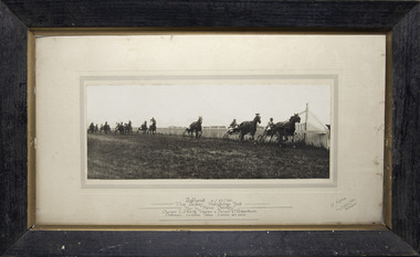 Victorian Harness Racing Heritage Collection at Lord's Raceway Bendigo
Photograph - Wooden framed photo finish, A Copley, New Derby, 6 December 1930
... by C Robertson. horses race winner driver trainer owner ...New Derby won The Redan Handicap Trot Ballarat on the 6 December 1930. New Derby owned by LJ King, was trained and driven by C Robertson. One large black and white photograph in a black frame. Top line: Ballarat / 6-12-30 Second line: The Redan Handicap Trot Third line: Won by "New Derby" Fourth line: Owner LJ King / Trainer & Driver C Robertson Bottom line: Distance 1 1/4 miles / Time 2 min 59 secs Bottom right corner: A Copley, 434a Flinders Street Near William St Melbournehorses, race, winner, driver, trainer, owner, ballarat, 1930, new derby, c robertson, lj king, a copley, charlie robertson, charlie robertson jnr, c robertson jnr -
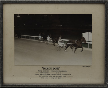 Victorian Harness Racing Heritage Collection at Lord's Raceway Bendigo
Photograph - Framed photo finish, Adrian Boddington, Dandy Don, 26 December 1953
... , was trained by T Taylor and driven by H Taylor. horses race winner ...Dandy Don won the Payne Handicap at Melbourne Showgrounds on the 26 December 1953. Dandy Don owned by Mr RR Cochrane, was trained by T Taylor and driven by H Taylor. One large coloured photograph in a black frame. Top line: "Dandy Don" Second line: Payne Handicap / Melbourne Showgrounds Third line: 12 1/2 furlongs / 26-12-53 Fourth line: Owner Mr RR Cochrane / Trainer T Taylor / Driver H Taylor Fifth line: 2nd Kaye Lois 4 yds / 3rd Lady Armat 3 yds Bottom line: Time 3.31 3/5 / Mile Rate 2.15 3/5 Under photo right corner: Adrian Boddingtonhorses, race, winner, driver, trainer, owner, melbourne showgrounds, 1953, dandy don, t taylor, h taylor, mr rr cochrane, kaye lois, lady armat -
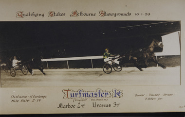 Victorian Harness Racing Heritage Collection at Lord's Raceway Bendigo
Photograph - Framed photo finish, Turfmaster, 10 January 1953
... owned, trained and driven by T Allen Jnr. horses race winner ...Turfmaster won the Qualifying Stakes at Melbourne Showgrounds on the 10 January 1953, followed by Marboe and Uranus. Turfmaster owned, trained and driven by T Allen Jnr. One large colour photograph in a white frame. At the top: Qualifying Stakes / Melbourne Showgrounds / 10-1-53 At the bottom: Left corner: Distance 11 furlongs/ Mile rate 2.14 Centre: Turfmaster 1st (Kings Gift - Vin Direct) / Marboe 2nd / Uranus 3rd Right corner: Owner Trainer Driver T Allen Jnrhorses, race, winner, driver, trainer, owner, melbourne showgrounds, turfmaster, t allen jnr, marboe, uranus -
 Charlton RSL Sub Branch
Photograph - Framed photo and story of 'War Cloud' horse transport, Charlton Horses to the front. WW1
Wood and glass frame with photo of horse transportPhoto of train carriages containing donated Charlton horses for the WW1 war effort. Also list of contributors and story -
 Victorian Harness Racing Heritage Collection at Lord's Raceway Bendigo
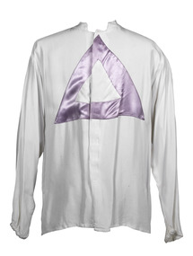
Clothing - Race colours, I.R. (Dick) Lee
Dick Lee is a prolific Group 1 winning trainer and driver, successful breeder and owner, International and trotting pioneer, outstanding administrator and tireless volunteer. Dick Lee, son of a soldier-settler was a track ranger at the Melbourne Showgrounds before accepting a position as a private trainer in the emerging trotting industry in Wales, taking a team of horses to the UK where he had 105 drives for 29 wins. The adventure would also see him compete in Holland, Germany, Sweden, Belgium, Russia and the US, always with trotters. He returned to Australia in 1970 with “a wife, a trainer-driver premiership, half-a-dozen miniature Irish donkeys and a horse in tow”. The horse, Hermes, would sire 1976 Melbourne Cup winner Van Der Hum. Dick served 12 years as president of the Victorian Square Trotters Association to advocate for the gait. Emerging from this time are: 1985 The Redwood Classic for 2yo trotters 1996 the first all-trotting card, the Redwood Day at Maryborough. Dick Lee’s training and driving produced among others: Bendigo and Melbourne Pacing Cups winner Rhodonite Australian Trotters of the Year Hampdens Pride and Game Ebony V L Dullard Cup winners Glenfield Girl and Game Ebony Rufus Youngblood, whose racing career included 32 wins, 23 seconds and 18 thirds from 139 starts, the first Australian-bred horse to win four Derbies and Australian Horse of the Year in 1987. Dick Lee was inducted into the Victorian Harness Racing Hall of Fame in 2019White race colours with purple triangle pointing upbendigo, bendigo cup, lord's raceway, dick lee, rhodonite, bendigo harness racing club, bhrc, race colour, hall of fame, ir (dick) lee, ir lee -
 Victorian Harness Racing Heritage Collection at Lord's Raceway Bendigo
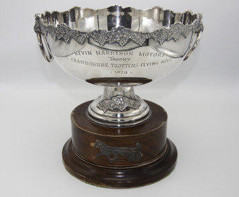
Memorabilia - Silver trophy, Maori's Idol, 1978 Cranbourne Trotting Club Flying Mile
Maori's Idol (Ike Frost Imp P 2.2.8 - Maori Miss Vic P 2.14.8 Tr 2.10.6 (Grand Monarch)) Bay Horse. Foaled 1972 (5th Foal). Breeder/Owner: R McD Healy & Co Pty Ltd. Trainer R McD Healy. Maori's Idol raced from 1976 (3yo) through to 1982 (9yo). Career: 40 wins 3 seconds 1 third 46 starts $98,820.20 1.59.3 Winning Driver: BR Healy (40). Won on 11 Tracks: Moonee Valley (16) Globe Derby SA (4) Albion Park Qld (2) Kilmore (5) Cranbourne (5) Bendigo (3) Stawell (1) Ballarat (1) Maryborough (1) Hamilton (1) Geelong (1)Maori's Idol won the 1978 Cranbourne Trotting Club Flying Mile at Cranbourne over 1 mile at a mile rate of 2.03.9. Driven by BR Healy. Defeating Hilton Adios 2nd and Touch Merchant 3rd.Silver Trophy on a Wooden BaseKevin Harrison Motors / Trophy / Cranbourne Trotters Flying Mile / 1978maoris idol, cranbourne, 1978, cranbourne trotting club flying mile, bryan healy, ric healy, r healy, br healy, b healy, r mcd healy -
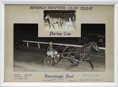 Victorian Harness Racing Heritage Collection at Lord's Raceway Bendigo
Photograph - Framed photo finish, Greg Matthews Photo, Raiarmagh Pool, 22 December 1967
Raiarmagh Pool won the Bendigo Pacing Cup on the 22 December 1967, followed by Ballon D'Essai and Optical. Raiarmagh Pool owned by Mr and Mrs Evans, was trained and driven by Gordon Rothacker. Raiarmagh Pool raced from 1966 (4yo) through to 1968 (6yo). Career: 20 wins 1 second 0 thirds 26 starts. Refer to Identifier 15.230 (Media) for Full Career Performance Record.Two colour photographs, one small one large in a white frame. At the top: Bendigo Trotting Club 22-12-67/ Pacing Cup At the bottom: Left corner: Distance 2600 metres/ Mile rate 2.8-1/5 / Greg Matthews Photo Centre: Raiarmagh Pool ( Raiarmagh - Main Pool) / Ballon d'essai 2nd / Optical 3rd Right corner: Owned by- Mr & Mrs G. Evans/ Trained and driven by - G. Rothackerbendigo harness racing club, horses, race, winner, bendigo trotting club, pacing cup, raiarmagh pool, gordon rothacker, driver, trainer, owner, 1967, ballon d'essai, optical, g rothacker, gw rothacker, g evans