Showing 486 items
matching kilometres
-
 Bendigo Historical Society Inc.
Map - Black and white map pertaining to Lake Eppalock
John Perry Collection. Laminated copy of map relating to Lake Eppalock. Lists dwellings, ford crossings and bridges. The dam was built by the State Rivers and Water Supply Commission of Victoria. The dam wall height is 45 metres (148 ft) and the main embankment is 1,041 metres (3,415 ft) long. At 100% capacity the dam wall was designed to hold back 304,651 megalitres (6.7014×10¹⁰ imp gal; 8.0480×10¹⁰ US gal) of water. The surface area of Lake Eppalock is 3,011 hectares (7,440 acres) and the catchment area is 2,124 square kilometres (820 sq mi). The controlled spillway is capable of discharging 8,040 cubic metres per second (284,000 cu ft/s). Lake Eppalock supplies both stock and domestic water to the Campaspe irrigation district. It also serves as a water supply to Bendigo and Heathcote and, in more recent times, Ballarat. The lake is a major attraction for those engaging in watersports, with a number of tourist parks and accommodation facilities available. Permissible activities on the lake include high-speed boating, water skiing, sailing, canoeing, fishing and swimming. The lake's water levels were low for approximately eight years between 2002 and 2010 during a prolonged drought, which restricted the amount of recreational activity until rainfall in the latter half of 2010 returned the lake to 100 percent capacity. Built between 1961 and 1964, Lake Eppalock remains the only water storage on the Campaspe River system.map, water, dam, reservoir, eppalock -
Bendigo Historical Society Inc.
Map - Black and white map pertaining to Lake Eppalock
John Perry Collection. Laminated copy of map pertaining to Lake Eppalock. Gives details of dwellings, bridges and ford crossings. The dam was built by the State Rivers and Water Supply Commission of Victoria. The dam wall height is 45 metres (148 ft) and the main embankment is 1,041 metres (3,415 ft) long. At 100% capacity the dam wall was designed to hold back 304,651 megalitres (6.7014×10¹⁰ imp gal; 8.0480×10¹⁰ US gal) of water. The surface area of Lake Eppalock is 3,011 hectares (7,440 acres) and the catchment area is 2,124 square kilometres (820 sq mi). The controlled spillway is capable of discharging 8,040 cubic metres per second (284,000 cu ft/s). Lake Eppalock supplies both stock and domestic water to the Campaspe irrigation district. It also serves as a water supply to Bendigo and Heathcote and, in more recent times, Ballarat. The lake is a major attraction for those engaging in watersports, with a number of tourist parks and accommodation facilities available. Permissible activities on the lake include high-speed boating, water skiing, sailing, canoeing, fishing and swimming. The lake's water levels were low for approximately eight years between 2002 and 2010 during a prolonged drought, which restricted the amount of recreational activity until rainfall in the latter half of 2010 returned the lake to 100 percent capacity. Built between 1961 and 1964, Lake Eppalock remains the only water storage on the Campaspe River system.eppalock, map, water, dam, reservoir -
Bendigo Historical Society Inc.
Document - Legend to maps A, B and C for Lake Eppalock
John Perry Collection. Laminated 'legend' for Maps A, B and C for Lake Eppalock also in this collection. Black and White definitions and descriptions of objects and markers found on maps. Circa 1951. The dam was built by the State Rivers and Water Supply Commission of Victoria. The dam wall height is 45 metres (148 ft) and the main embankment is 1,041 metres (3,415 ft) long. At 100% capacity the dam wall was designed to hold back 304,651 megalitres (6.7014×10¹⁰ imp gal; 8.0480×10¹⁰ US gal) of water. The surface area of Lake Eppalock is 3,011 hectares (7,440 acres) and the catchment area is 2,124 square kilometres (820 sq mi). The controlled spillway is capable of discharging 8,040 cubic metres per second (284,000 cu ft/s). Lake Eppalock supplies both stock and domestic water to the Campaspe irrigation district. It also serves as a water supply to Bendigo and Heathcote and, in more recent times, Ballarat. The lake is a major attraction for those engaging in watersports, with a number of tourist parks and accommodation facilities available. Permissible activities on the lake include high-speed boating, water skiing, sailing, canoeing, fishing and swimming. The lake's water levels were low for approximately eight years between 2002 and 2010 during a prolonged drought, which restricted the amount of recreational activity until rainfall in the latter half of 2010 returned the lake to 100 percent capacity. Built between 1961 and 1964, Lake Eppalock remains the only water storage on the Campaspe River system.map, water, dam, reservoir, eppalock -
Bendigo Historical Society Inc.
Map - Map of overlay of lake Eppalock at full capacity. Map 'C'
John Perry collection. Map 'C'. Laminated map of overlay of Lake Eppalock at full capacity. Circa 1951. The dam was built by the State Rivers and Water Supply Commission of Victoria. The dam wall height is 45 metres (148 ft) and the main embankment is 1,041 metres (3,415 ft) long. At 100% capacity the dam wall was designed to hold back 304,651 megalitres (6.7014×10¹⁰ imp gal; 8.0480×10¹⁰ US gal) of water. The surface area of Lake Eppalock is 3,011 hectares (7,440 acres) and the catchment area is 2,124 square kilometres (820 sq mi). The controlled spillway is capable of discharging 8,040 cubic metres per second (284,000 cu ft/s). Lake Eppalock supplies both stock and domestic water to the Campaspe irrigation district. It also serves as a water supply to Bendigo and Heathcote and, in more recent times, Ballarat. The lake is a major attraction for those engaging in watersports, with a number of tourist parks and accommodation facilities available. Permissible activities on the lake include high-speed boating, water skiing, sailing, canoeing, fishing and swimming. The lake's water levels were low for approximately eight years between 2002 and 2010 during a prolonged drought, which restricted the amount of recreational activity until rainfall in the latter half of 2010 returned the lake to 100 percent capacity. Built between 1961 and 1964, Lake Eppalock remains the only water storage on the Campaspe River system.map, water, eppalock, dam, reservoir -
Bendigo Historical Society Inc.
Map - Laminated map of Lake Eppalock empty. Map 'D'
John Perry Collection. Laminated map of Lake Eppalock empty. Map 'D'. Circa 1951. The dam was built by the State Rivers and Water Supply Commission of Victoria. The dam wall height is 45 metres (148 ft) and the main embankment is 1,041 metres (3,415 ft) long. At 100% capacity the dam wall was designed to hold back 304,651 megalitres (6.7014×10¹⁰ imp gal; 8.0480×10¹⁰ US gal) of water. The surface area of Lake Eppalock is 3,011 hectares (7,440 acres) and the catchment area is 2,124 square kilometres (820 sq mi). The controlled spillway is capable of discharging 8,040 cubic metres per second (284,000 cu ft/s). Lake Eppalock supplies both stock and domestic water to the Campaspe irrigation district. It also serves as a water supply to Bendigo and Heathcote and, in more recent times, Ballarat. The lake is a major attraction for those engaging in watersports, with a number of tourist parks and accommodation facilities available. Permissible activities on the lake include high-speed boating, water skiing, sailing, canoeing, fishing and swimming. The lake's water levels were low for approximately eight years between 2002 and 2010 during a prolonged drought, which restricted the amount of recreational activity until rainfall in the latter half of 2010 returned the lake to 100 percent capacity. Built between 1961 and 1964, Lake Eppalock remains the only water storage on the Campaspe River system.map, water, dam, reservoir, eppalock -
Bendigo Historical Society Inc.
Document - Collection of photographs from newspaper on a single page
John Perry Collection. Laminated copy of page from 'Weekly Times' newspaper, February, 1962. Nine images relating to establishing and building Eppalock Reservoir, 15 miles from Bendigo. The dam was built by the State Rivers and Water Supply Commission of Victoria. The dam wall height is 45 metres (148 ft) and the main embankment is 1,041 metres (3,415 ft) long. At 100% capacity the dam wall was designed to hold back 304,651 megalitres (6.7014×10¹⁰ imp gal; 8.0480×10¹⁰ US gal) of water. The surface area of Lake Eppalock is 3,011 hectares (7,440 acres) and the catchment area is 2,124 square kilometres (820 sq mi). The controlled spillway is capable of discharging 8,040 cubic metres per second (284,000 cu ft/s). Lake Eppalock supplies both stock and domestic water to the Campaspe irrigation district. It also serves as a water supply to Bendigo and Heathcote and, in more recent times, Ballarat. The lake is a major attraction for those engaging in watersports, with a number of tourist parks and accommodation facilities available. Permissible activities on the lake include high-speed boating, water skiing, sailing, canoeing, fishing and swimming. The lake's water levels were low for approximately eight years between 2002 and 2010 during a prolonged drought, which restricted the amount of recreational activity until rainfall in the latter half of 2010 returned the lake to 100 percent capacity. Built between 1961 and 1964, Lake Eppalock remains the only water storage on the Campaspe River system. dam, engineering, water, eppalock -
Bendigo Historical Society Inc.
Map - Laminated map of Lake Eppalock at full capacity
John Perry Collection. Laminated copy of map of Lake Eppalock at full capacity. Had highlighter markings of old roads which appear to be still in use. The dam was built by the State Rivers and Water Supply Commission of Victoria. The dam wall height is 45 metres (148 ft) and the main embankment is 1,041 metres (3,415 ft) long. At 100% capacity the dam wall was designed to hold back 304,651 megalitres (6.7014×10¹⁰ imp gal; 8.0480×10¹⁰ US gal) of water. The surface area of Lake Eppalock is 3,011 hectares (7,440 acres) and the catchment area is 2,124 square kilometres (820 sq mi). The controlled spillway is capable of discharging 8,040 cubic metres per second (284,000 cu ft/s). Lake Eppalock supplies both stock and domestic water to the Campaspe irrigation district. It also serves as a water supply to Bendigo and Heathcote and, in more recent times, Ballarat. The lake is a major attraction for those engaging in watersports, with a number of tourist parks and accommodation facilities available. Permissible activities on the lake include high-speed boating, water skiing, sailing, canoeing, fishing and swimming. The lake's water levels were low for approximately eight years between 2002 and 2010 during a prolonged drought, which restricted the amount of recreational activity until rainfall in the latter half of 2010 returned the lake to 100 percent capacity. Built between 1961 and 1964, Lake Eppalock remains the only water storage on the Campaspe River system.map, water, dam, reservoir, eppalock -
Bendigo Historical Society Inc.
Map - Black and White map. Outline of Lake Eppalock. Map 'B'
John Perry Collection. Laminated copy black and white map. Map 'B'. Outline of Lake Eppalcok, overlayed on map. Circa 1951. The dam was built by the State Rivers and Water Supply Commission of Victoria. The dam wall height is 45 metres (148 ft) and the main embankment is 1,041 metres (3,415 ft) long. At 100% capacity the dam wall was designed to hold back 304,651 megalitres (6.7014×10¹⁰ imp gal; 8.0480×10¹⁰ US gal) of water. The surface area of Lake Eppalock is 3,011 hectares (7,440 acres) and the catchment area is 2,124 square kilometres (820 sq mi). The controlled spillway is capable of discharging 8,040 cubic metres per second (284,000 cu ft/s). Lake Eppalock supplies both stock and domestic water to the Campaspe irrigation district. It also serves as a water supply to Bendigo and Heathcote and, in more recent times, Ballarat. The lake is a major attraction for those engaging in watersports, with a number of tourist parks and accommodation facilities available. Permissible activities on the lake include high-speed boating, water skiing, sailing, canoeing, fishing and swimming. The lake's water levels were low for approximately eight years between 2002 and 2010 during a prolonged drought, which restricted the amount of recreational activity until rainfall in the latter half of 2010 returned the lake to 100 percent capacity. Built between 1961 and 1964, Lake Eppalock remains the only water storage on the Campaspe River system.map, water, dam, reservoir, eppalock -
Bendigo Historical Society Inc.
Map - General view of area of proposed construction of Lake Eppalock. Map 'A'
John Perry Collection. Laminated map of proposed construction of Lake Eppalock. Map 'A'. Black and white map in laminate. Circa 1951. The dam was built by the State Rivers and Water Supply Commission of Victoria. The dam wall height is 45 metres (148 ft) and the main embankment is 1,041 metres (3,415 ft) long. At 100% capacity the dam wall was designed to hold back 304,651 megalitres (6.7014×10¹⁰ imp gal; 8.0480×10¹⁰ US gal) of water. The surface area of Lake Eppalock is 3,011 hectares (7,440 acres) and the catchment area is 2,124 square kilometres (820 sq mi). The controlled spillway is capable of discharging 8,040 cubic metres per second (284,000 cu ft/s). Lake Eppalock supplies both stock and domestic water to the Campaspe irrigation district. It also serves as a water supply to Bendigo and Heathcote and, in more recent times, Ballarat. The lake is a major attraction for those engaging in watersports, with a number of tourist parks and accommodation facilities available. Permissible activities on the lake include high-speed boating, water skiing, sailing, canoeing, fishing and swimming. The lake's water levels were low for approximately eight years between 2002 and 2010 during a prolonged drought, which restricted the amount of recreational activity until rainfall in the latter half of 2010 returned the lake to 100 percent capacity. Built between 1961 and 1964, Lake Eppalock remains the only water storage on the Campaspe River system.map, dam, water, weir, eppalock -
Bendigo Historical Society Inc.
Map - Laminated worksheet - identification of inundated artifacts at Lake Eppalock
John Perry Collection. Laminated copy of worksheet identifying inundated artifacts at Lake Eppalock when at 10% capacity. The dam was built by the State Rivers and Water Supply Commission of Victoria. The dam wall height is 45 metres (148 ft) and the main embankment is 1,041 metres (3,415 ft) long. At 100% capacity the dam wall was designed to hold back 304,651 megalitres (6.7014×10¹⁰ imp gal; 8.0480×10¹⁰ US gal) of water. The surface area of Lake Eppalock is 3,011 hectares (7,440 acres) and the catchment area is 2,124 square kilometres (820 sq mi). The controlled spillway is capable of discharging 8,040 cubic metres per second (284,000 cu ft/s). Lake Eppalock supplies both stock and domestic water to the Campaspe irrigation district. It also serves as a water supply to Bendigo and Heathcote and, in more recent times, Ballarat. The lake is a major attraction for those engaging in watersports, with a number of tourist parks and accommodation facilities available. Permissible activities on the lake include high-speed boating, water skiing, sailing, canoeing, fishing and swimming. The lake's water levels were low for approximately eight years between 2002 and 2010 during a prolonged drought, which restricted the amount of recreational activity until rainfall in the latter half of 2010 returned the lake to 100 percent capacity. Built between 1961 and 1964, Lake Eppalock remains the only water storage on the Campaspe River system.map, artifacts, eppalock, reservoir -
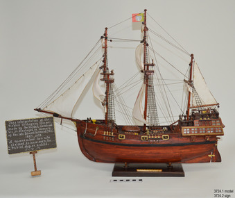 Flagstaff Hill Maritime Museum and Village
Craft - Ship Model, Portuguese Carvel, 1999
The Mahogany Ship is today regarded as a legend and refers to an ancient wreck that is purported to lie beneath the sand beside Armstrong Bay, several kilometres west of Warrnambool, Its location is currently unknown. For well over a century the mystery of this ship has fascinated Australians because the existence of such a vessel could throw a different light on the earliest phases of exploration of eastern Australia by Europeans. The story is that in January 1836 a party of whalers from Port Fairy travelled to the mouth of the Hopkins River in search of seals. Their boat overturned and one man was drowned. The three survivors were walking the 30 kilometres back to Port Fairy along the coast when, about halfway along, they discovered the wrecked ship in the dunes. It is said that Captain John Mills, who was in charge of the whaling station at Port Fairy promptly visited the wreck with several of his men, including Hugh Donnelly. Donnelly who was the originator of that version of events is now regarded as unreliable. Local history researcher Joan Fawcett believes Donnelly could not have visited the wreck in 1836 because he did not arrive in Victoria until 1841. The "mahogany" description can be traced to a letter from Port Fairy builder, architect and surveyor John Mason and published in the Melbourne Argus in 1876. He said he had seen the hull in 1846 and it "had the appearance of either cedar or mahogany." In 1884 Argus journalist `The Vagabond' wrote that the hull was built of "Spanish mahogany" and six years later Mason wrote another letter saying it might not have been mahogany but red gum or ironbark from New South Wales. He was too late with this new description as the wrecks mahogany tag was here to stay all through the hull was not visible as it had disappeared beneath the shifting sands by 1880. A more reliable account was later presented by the former editor of the Warrnambool Examiner, historian Richard Osburne, who wrote about the wreck in his book History of Warrnambool (published 1887). In it the author remembers to have noticed a wreck in the hummocks between Belfast and Warrnambool, in 1847 or 1848; he stated it was much nearer Warrnambool than Belfast, now known as Port Fairy, going on to state “in fact, it was only two or three miles from the former place, to the west of the big hummock which was supposed to fill Warrnambool Bay with drift sand washed by the Merri River before the cutting was made.” Osburne followed up with a letter to the Port Fairy Gazette on June 25, 1876, during a period of heightened interest in the wreck, although he was unsure of the provenance of the ship he went on to state in his letter. “The old wreck was, in fact, miles away from the Port Fairy beach, and only about four miles from Warrnambool. In the years 1847 and 1848. I have often seen the wreck and I regret to say I do not believe she was a foreign ship at all.”The ship model is significant for its association with the Warrnambool story of what is now referred to as the Mahogany Ship, an ancient shipwreck. The model is significant as it is an interpretation of a Portuguese caravel and possibly associated with the early history and exploration of Southern Australia. The model is a fine example of a hand crafted ship made from plans, not from a kit. Some of the materials used for the model are significant to the Gembrook community in that the timber used is a portion from a 30-meter pine tree that fell onto and destroyed the 120-year-old Gembrook church building. The model is also a dedication to Edward Kermond, who grew up in Warrnambool and claimed to have seen the shipwreck in the dunes when he was a lad in the late 19th century. (See note section of this document for further information on the creator and donation of the subject item).Ship model, an interpretation of a mahogany Portuguese carvel vessel in a glass display case with wood frame and a description plaque. Model is made from dark stained wood. The three masted vessel is fully rigged, with a Portuguese-like flag on mast. Plaque is rectangular, free standing on a pedestal. The model was handmade by Joe Hilder (Senior) in 1999 from flooring obtained from the Gembrook Uniting Church in Victoria. Inscriptions, hand written, under base of case and on plaque.Under base, black felt tip pen “Ship & Case made From / Flooring from Gembrook uniting Church, Flattened in 1999 / By Large Pine Tree.” On plaque, white paint "This interpretation of the Fabled Mahogany Ship was made by Joe Hilder, Gembrook Vic. is displayed in the memory of the late Edward Kermond (Ted) 1887-1973, a Warrnambool son who claimed to have seen the original ship as a child." flagstaff hill, warrnambool, flagstaff hill maritime museum, shipwreck coast, flagstaff hill maritime village, great ocean road, ship model, mahogany ship, mahogany ship story, portuguese caravel, joe hilder, edward kermond, ted kermond, gembrook uniting church, gembrook storm 1999, port fairy whalers, belfast whalers -
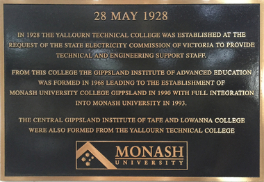 Federation University Historical Collection
Photograph - Photograph - Colour, Clare Gervasoni, Historical Plaques at Federation University Australia Gippsland Campus
The following information was the preface of the 1985 GIAE handbook: The Gippsland institute of Advanced Education was established by an Order-in-Council in September, 1968, but, owes its origin to engineering diploma courses established in 1928 to service the developing electrical industry. The Council of the Institute includes members of the Gippsland community who are prominent in industry, commerce, education and the professions, the Director of the institute, the representative of the academic staff, of general staff, of students and of the Convocation of the Institute. In 1972 the Institute occupied the first of its permanent buildings on a large campus in rural surroundings near the township of Churchill, ten kilometres south of Morwell and one hundred and sixty kilometres east of Melbourne. Engineering laboratories are temporarily located in buildings on the site of the Yallourn College of TAFE at Newborough and they will be consolidated on the Churchill campus by the end on 1985. In 1974 new buildings were completed under a self-help program to house the School of Visual Arts. A building complex to provide the first stages of the permanent library and the Union, and accommodation for the School of Business and Social Sciences was completed in 1976. An Education building, an Applied Science building and student residential buildings for 108 student places were completed at the beginning on 1976. The Binishell, a multi-purpose facility was completed in 1980. On its establishment, the Institute assumed responsibility for the diploma courses which were previously offered by the Yallourn Technical College. These were diploma in Civil, Electrical, and Mechanical Engineering, Applied Chemistry, and Business, all of which were recognised by the appropriate professional bodies. The Gippsland Institute of Advanced Education is the only centre of Higher Education east of Melbourne and offers a range of vocational courses at associate diploma, diploma, degree, graduate degree and master levels to meet the educational needs of the Gippsland regions. The institute also has a very large commitment to a program on external studies. Federation University Australia was established on 1 January 2014. Formerly known as the University of Ballarat, its enabling legislation was the University of Ballarat Amendment (Federation University Australia) Act 2013. Although formally created as a University in 1994, the University of Ballarat had a lineage back to 1870 with the establishment of the School of Mines Ballarat, making it the third institution of higher learning to be established in Australia and the first to be established in regional Australia. On 1 January 1994, Ballarat University College became the University of Ballarat and in 1998 the University merged with three TAFE Institutes to become a dual sector institution with multiple campuses. On 1 January 2014, the University of Ballarat amalgamated with the Monash University Gippsland Campus to form Federation University Australia. The Gippsland Campus also had a long lineage dating back to 1928 with the establishment of the Yallourn Technical School which became a predecessor institution to the Gippsland College of Advanced Education formed in 1968. In 1990, it was renamed the Monash University College and in 1993 became the Gippsland Campus of Monash University.4 plaques placed on the wall of 'The Knuckle' at Federation University Gippsland Campus. .1) Brown and brass coloured plaque commemorating the establishment of Yallourn Technical School. .2) Brass plaque commemorating the opening of the Gippsland Institute of Advanced Education. .3) Brass plaque commemorating the affiliation between Gippsland Institute of Advanced Education and Monash University. .4) Plaque commemorating .1) 28 May 1928 In 1928 the Yallourn Technical College was established at the request of the State Electricity Commission of Victoria to provide technical and engineering support to staff. From this College the Gippsland Institute of Advanced Education was formed in 1968 leading to the establishment of Monash University College Gippsland in 1990 with full integration into Monash University in 1993. .2) The Gippsland Institute of Advanced Education was officially opened on the 20th November, 1976 by Senator The Honourable J.L. Carrick Minister of State for Education and The Honourable L.H.S. Thompson C.M.G., M.P. Deputy-Premier of Victoria and Minister of Education. .3) Monash University Gippsland Institute of Advanced Education At this campus on 24 February 1989 and in the presence of the Honourable John Dawkins, the Federal Minister for Employment, Education and Training, and representatives of the Gippsland community, affiliation documents were signed and exchanged. On 01 July 1990, the Gippsland Institute became the Monash University College Gippsland as a constituent of Monash University. Professor Tom Kennedy Professor Mal Logan Pro Vice-Chancellor Vice-Chancellor .4) Monash University Gippsland Campus On 25 August 1992 the Advisory Council of Monash University College Gippsland endorsed the integration of the University College into Monash University from 1 January 1993. Professor Tom Kennedy Mr Crofton Hatsell Pro Vice-Chancellor Chair, Advisory Council Professor Mal Logan, Vice-Chancellorfederaton university, yallourn technical college, state electricity commission of victoria, gippsland institute of advanced education, monash university college gippsland, monash university, central gippsland institute of tafe, lowanna college, lindsay thompson, j.l. carrick, tom kennedy, crofton hatsell, mal logan, john dawkins, gippsland institute, gippsland campus collection -
 Federation University Historical Collection
Photograph - Photograph - Colour, Federation University Gippsland Campus, c1995, c1995
The following information was the preface of the 1985 GIAE handbook: The Gippsland institute of Advanced Education was established by an Order-in-Council in September, 1968, but, owes its origin to engineering diploma courses established in 1928 to service the developing electrical industry. The Council of the Institute includes members of the Gippsland community who are prominent in industry, commerce, education and the professions, the Director of the institute, the representative of the academic staff, of general staff, of students and of the Convocation of the Institute. In 1972 the Institute occupied the first of its permanent buildings on a large campus in rural surroundings near the township of Churchill, ten kilometres south of Morwell and one hundred and sixty kilometres east of Melbourne. Engineering laboratories are temporarily located in buildings on the site of the Yallourn College of TAFE at Newborough and they will be consolidated on the Churchill campus by the end on 1985. In 1974 new buildings were completed under a self-help program to house the School of Visual Arts. A building complex to provide the first stages of the permanent library and the Union, and accommodation for the School of Business and Social Sciences was completed in 1976. An Education building, an Applied Science building and student residential buildings for 108 student places were completed at the beginning on 1976. The Binishell, a multi-purpose facility was completed in 1980. On its establishment, the Institute assumed responsibility for the diploma courses which were previously offered by the Yallourn Technical College. These were diploma in Civil, Electrical, and Mechanical Engineering, Applied Chemistry, and Business, all of which were recognised by the appropriate professional bodies. The Gippsland Institute of Advanced Education is the only centre of Higher Education east of Melbourne and offers a range of vocational courses at associate diploma, diploma, degree, graduate degree and master levels to meet the educational needs of the Gippsland regions. The institute also has a very large commitment to a program on external studies. Federation University Australia was established on 1 January 2014. Formerly known as the University of Ballarat, its enabling legislation was the University of Ballarat Amendment (Federation University Australia) Act 2013. Although formally created as a University in 1994, the University of Ballarat had a lineage back to 1870 with the establishment of the School of Mines Ballarat, making it the third institution of higher learning to be established in Australia and the first to be established in regional Australia. On 1 January 1994, Ballarat University College became the University of Ballarat and in 1998 the University merged with three TAFE Institutes to become a dual sector institution with multiple campuses. On 1 January 2014, the University of Ballarat amalgamated with the Monash University Gippsland Campus to form Federation University Australia. The Gippsland Campus also had a long lineage dating back to 1928 with the establishment of the Yallourn Technical School which became a predecessor institution to the Gippsland College of Advanced Education formed in 1968. In 1990, it was renamed the Monash University College and in 1993 became the Gippsland Campus of Monash University. Large photograph adhered to foamcore showing an aerial view of the Federation University Gippsland Campus at Churchill, Victoria as it was c1995.churchill, gippsland campus, gippsland institute of advanced education, federation university, yallourn, morwell, binishell -
 The Beechworth Burke Museum
Photograph, 2000
Woolshed is a small area about five kilometres north west of Beechworth, and almost about 225km north east of Melbourne. When gold was discovered at the nearby Spring Creek in February 1852, Woolshed was one of three settlements set up to house miners and their families. At its peak in 1857, Woolshed was also populated by 29 storekeepers and 14 hotels, as well as the Woolshed State School, which stood near where this photograph was taken. The school often played host to public meetings, as well as a public dance in 1897. The school was subject to some controversy in 1874 when one parent complained about the head of the school in the local newspaper, the Owens and Murray Advertiser, and at least three letters to the editor were exchanged between the two. According to the parent, C. O'Donoghue was not providing enough amusement for the children and was disrespectful to parents and staff. When the State Governor, Sir Reginald Talbot, visited Beechworth in 1906, the school organised a celebratory welcome. The Woolshed State School was ultimately closed in 1922 as miners had exhausted the Spring Creek gold supply and were moving elsewhere. This photograph, taken in about 2000, shows the trees that grew on or near the site of the original school. The Woolshed State School Honour Roll, with a list of the men from the school who served in the First World War, also still exists. It is stored in the Beechworth RSL as of 2015.This photograph is significant for its connection to an important site in Beechworth's gold mining history. Woolshed served a significant community of miners, with a population of at least 138 according to the 1911 census, with families that needed the school site to ensure their children's education. The image is also useful for prompting discussion about how Beechworth has changed over time, with the photograph taken 78 years after the school closed down.A colour rectangular photograph printed on glossy photographic paper.Woolshed State. / School site / 2000 / - remnant trees / / cobeechworth, burke museum, school, education, trees, nature, state school, woolshed, gold mining, teachers, over time, owens and murray advertiser, public meetings, public dance, c. o'donoghue, spring creek, state governor, sir reginald talbot, miners, honour roll, world war 1 -
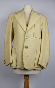 National Wool Museum
Clothing - Jacket, 1978
The wool for this jacket began on the back of two sheep many kilometres apart. The first fleece for the warp was shorn from a single Merino at Currotha in Moree, NSW. The wool was 21-22 micron and the bloodline is a cross between Bundemar, Rossmore and Eural. The second sheep that provided wool for the weft was shorn in Beaufort, Victoria. It was a single Corriedale fleece shorn at Niawanda. The distance between these two towns is approximately 1250kms; a 15-hour car ride between paddocks. The two fleeces were spun and weaved together by the donor’s mother, Marjorie Allnutt. A level of talent is required to spin Merino fleeces. It is easier to spin cross bred wool, such as Corriedale, because it is less dense and much easier to comb, card and then tease out for a spinning wheel. The donor Philip Allnutt had a suit tailored out of the completed fabric at Ravensdale J & Son, 37 Swanson Street, Melbourne. The tailor was then a member of the Master Tailors Federation of Victoria. The business closed around 1986. Adding to the jacket’s story is its relationship to the household board game “Squatter”. Marjorie Allnutt was the sister-in-law of Robert Crofton Lloyd, the inventor of the wool themed boardgame. With more than 500,000 games sold in Australia as of 2007, it is the most successful board game ever produced in the country. The original “Squatter” board game is located within the National Wool Museum’s Collection. Philip Allnutt donated the Jacket to the National Wool Museum Collection in 2021. Cream singled breasted jacket with a narrow overlap and one column of buttons for fastening. The jacket features notched lapels of a medium width and two buttons of a cream & brown marble. The jacket has three visible pockets. A jetted pocket with no flap is on the right breast. A further two jetted no flap pockets finish an inch above the hem, on either side of the opening. Internally, the jacket features a further two pockets and a white silk lining for comfort. At the cuffs, the jacket utilises another 2 buttons of the same cream & brown marble.merino, currotha, moree, nsw, niawanda, corriedale, beaufort, victoria, hand spun, hand weaved -
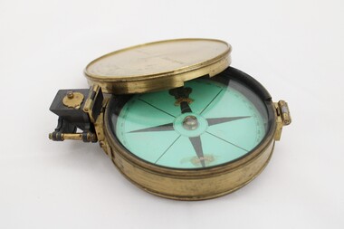 National Communication Museum
Equipment - Prismatic compass, Alfred E Sawtell, before 1872
After years of precursory surveying, debate and proposals the most ambitious civil engineering project of the day, the Overland Telegraph Line, began construction in September 1870. Superintendent of Telegraphs, Sir Charles Todd led the construction through “terra incognita,” guided by the precursory surveys of John McDowall Stuart and technologies such as his prismatic surveying compass. The unknown and hostile landscape claimed the lives of several men and scores of transport animals in the dogged pursuit of telegraphic connection to the rest of the world. Completed in August 1872, the Line connected Australia to the world via telegraph wires running 3,200 kilometres from Port Augusta in South Australia, to Darwin, then connecting via submarine cable to Java and beyond. The “earth [had been] girdled with a magic chain” according to the then Governor of New South Wales, Sir Hercules Robinson. How does it work? For use in surveying, the sight vane and prism are turned up on their hinge and the instrument is held horizontally either in the palm of one's hand or on a tripod. Two small discs of red and green glass attached to the prism can be flipped down over the sight line to reduce glare. The objective is to bring the subject into the sightline created by the prism, aligning with the thread of the sight-vane until the subject is bisected evenly. Once aligned, the division on the card may be read through the prism. This reading provides the magnetic azimuth, used for calculating the bearings of distant landmarks. Circular instrument mounted in a brass case with glass window and brass lid. The compass card face four black compass points printed on mint green paper; on the underside the magnetic needle would be affixed, all held in place by a brass knob at the centre. The arched labels of "Sawtell" and "Adelaide" and the Prince of Wales feathers appear to have been affixed with adhesive which has since yellowed in the areas of application on the compass card. The compass face is printed with numbers, every 10 degrees from 10 - 360, printed in reverse indicating this compass would have once held a mirror at the sighting bracket. On one side of the brass case is a brass hinged sighting-prism, possibly of ebonite. The sighting-prism is mounted in a hinged brass bracket on one edge of the brass case. It has two flip-type filter glasses (red and green) and folds down into a retracted travelling position. A hinged brass bracket on the opposite edge would have held the sighting bracket - carrying the sighting vane and mirror - which is now missing or removed. Under the hinge is a lever, possibly related to the movement of the bracket. Underneath the brass case is an indented circle with screw threads, possibly for attachment to a tripod, and indistinguishable marks scratched into the surface.Etched on to the centre of the lid, "Sawtell ADELAIDE / No 792." Affixed to the paper compass face, possibly from separate pieces of paper, "SAWTELL / ADELAIDE" with the Prince of Wales Feathers above "SAWTELL". Underneath on remains of white tape in red: "159."surveying, compass, charles todd, overland telegraph line, telegraph -
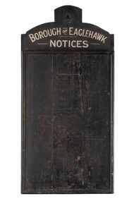 City of Greater Bendigo - Civic Collection
Sign - Borough of Eaglehawk Notices, Borough of Eaglehawk, Unknown
This notice board was used by the Borough of Eaglehawk to inform the community about services and events taking place in the local community and was hung in the Town Hall. Eaglehawk was first incorporated as a borough on 29 July 1862. It had nine councillors, who represented the entire borough. Councillors met at the Town Hall (incorporating the Star Cinema) at the intersection of Sailors Gully Road and Loddon Valley Highway, Eaglehawk. The Town hall has always been the centre of the Borough's activities and was built in 1901 on the site of an earlier town hall which had stood on the location since 1865. The Victorian Heritage Database notes: "The present building replaced this earlier building and was opened on 14 August 1901. The architects were the Melbourne firm of Wilkinson and Permewan. As a much larger and more sumptuous building of brick and stone featuring a central clock tower, the new hall reflected prevailing architectural fashion and was a remarkable investment for a town consisting predominantly of poor mining families. The condition of the town hall is substantially as built. The design is almost identical to the Castlemaine Town Hall." Eaglehawk was a local government area which covered the northwestern suburbs of the regional city of Bendigo and covered an area of 14.54 square kilometres (5.6 sq mi). On 7 April 1994, the Borough of Eaglehawk was abolished, and along with the City of Bendigo, the Rural City of Marong and the Shires of Huntly and Strathfieldsaye, was merged into the newly created City of Greater Bendigo.Handmade wooden notice board. Wood is roughly hewn and painted black with painted silver text. The front of the board is covered in pin holes. borough of eaglehawk -
Bendigo Historical Society Inc.
Document - Directions to Lake Eppalock with road descriptions and map
John Perry Collection. Laminated copy of 'Directions to Lake Eppalock'. Gives directions in relationship of Lake Eppalock to Bendigo, Kyneton and Heathcote. Undated. Gives basic descriptions of bridges on lakebed, ford crossings on lakebed and inundated dwellings on lakebed. The dam was built by the State Rivers and Water Supply Commission of Victoria. The dam wall height is 45 metres (148 ft) and the main embankment is 1,041 metres (3,415 ft) long. At 100% capacity the dam wall was designed to hold back 304,651 megalitres (6.7014×10¹⁰ imp gal; 8.0480×10¹⁰ US gal) of water. The surface area of Lake Eppalock is 3,011 hectares (7,440 acres) and the catchment area is 2,124 square kilometres (820 sq mi). The controlled spillway is capable of discharging 8,040 cubic metres per second (284,000 cu ft/s). Lake Eppalock supplies both stock and domestic water to the Campaspe irrigation district. It also serves as a water supply to Bendigo and Heathcote and, in more recent times, Ballarat. The lake is a major attraction for those engaging in watersports, with a number of tourist parks and accommodation facilities available. Permissible activities on the lake include high-speed boating, water skiing, sailing, canoeing, fishing and swimming. The lake's water levels were low for approximately eight years between 2002 and 2010 during a prolonged drought, which restricted the amount of recreational activity until rainfall in the latter half of 2010 returned the lake to 100 percent capacity. Built between 1961 and 1964, Lake Eppalock remains the only water storage on the Campaspe River system.water, dam, directions, eppalock -
Bendigo Historical Society Inc.
Map - Map of Lake Eppalock shoreline when empty
John Perry Collection. Laminated copy of map detailing Lake Eppalock shoreline when empty. Circa 1951. Has colored highlighter lines following roads leading to lake shoreline and various inundated old roads and tracks on lakebed. The dam was built by the State Rivers and Water Supply Commission of Victoria. The dam wall height is 45 metres (148 ft) and the main embankment is 1,041 metres (3,415 ft) long. At 100% capacity the dam wall was designed to hold back 304,651 megalitres (6.7014×10¹⁰ imp gal; 8.0480×10¹⁰ US gal) of water. The surface area of Lake Eppalock is 3,011 hectares (7,440 acres) and the catchment area is 2,124 square kilometres (820 sq mi). The controlled spillway is capable of discharging 8,040 cubic metres per second (284,000 cu ft/s). Lake Eppalock supplies both stock and domestic water to the Campaspe irrigation district. It also serves as a water supply to Bendigo and Heathcote and, in more recent times, Ballarat. The lake is a major attraction for those engaging in watersports, with a number of tourist parks and accommodation facilities available. Permissible activities on the lake include high-speed boating, water skiing, sailing, canoeing, fishing and swimming. The lake's water levels were low for approximately eight years between 2002 and 2010 during a prolonged drought, which restricted the amount of recreational activity until rainfall in the latter half of 2010 returned the lake to 100 percent capacity. Built between 1961 and 1964, Lake Eppalock remains the only water storage on the Campaspe River system.map, eppalock, reservoir, lake, water -
Bendigo Historical Society Inc.
Document - Black and white laminated photo of flow of water from Lake Eppalock. 1964
John Perry Collection. Laminated copy of photo of crowd watching flow of water from the opened valve at the wall of Lake Eppalock during its commissioning. March, 1964. Lake Eppalock was created by flooding to town of Wild Duck. The dam was built by the State Rivers and Water Supply Commission of Victoria. The dam wall height is 45 metres (148 ft) and the main embankment is 1,041 metres (3,415 ft) long. At 100% capacity the dam wall was designed to hold back 304,651 megalitres (6.7014×10¹⁰ imp gal; 8.0480×10¹⁰ US gal) of water. The surface area of Lake Eppalock is 3,011 hectares (7,440 acres) and the catchment area is 2,124 square kilometres (820 sq mi). The controlled spillway is capable of discharging 8,040 cubic metres per second (284,000 cu ft/s). Lake Eppalock supplies both stock and domestic water to the Campaspe irrigation district. It also serves as a water supply to Bendigo and Heathcote and, in more recent times, Ballarat. The lake is a major attraction for those engaging in watersports, with a number of tourist parks and accommodation facilities available. Permissible activities on the lake include high-speed boating, water skiing, sailing, canoeing, fishing and swimming. The lake's water levels were low for approximately eight years between 2002 and 2010 during a prolonged drought, which restricted the amount of recreational activity until rainfall in the latter half of 2010 returned the lake to 100 percent capacity. Built between 1961 and 1964, Lake Eppalock remains the only water storage on the Campaspe River system.water, dam, reservoir, eppalock, wild duck -
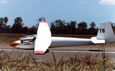 Australian Gliding Museum
Machine - Glider – Sailplane, 1963
The Skylark 4, the final in the Slingsby Skylark series, dates from 1961. The design heralded a trend towards the use of plastics in the construction of gliders. Slingsby incorporated GRP (glass reinforced plastic) panels to achieve a streamlined fuselage nose and cockpit area while retaining the more traditional wood techniques for the rest of the aircraft. Another notable feature was the smooth wing surface that was obtained using a Gaboon ply skin across the ribs. Best glide performance of 1:33 was found to be comparable with the early full GRP glider designs. The Museum’s example (VH-GTB – C/N 1382) was built in 1963 and originally owned by Chuck Bentson of the UK. It was brought to Australia in 1967 by Jeremy Picket-Heaps and flown at various places including Benalla, Cooma and Gundaroo. In 1970 the glider was transferred to the New England Soaring Club. Many flights were made from Armidale and Bellata in Northern New South Wales. On one occasion, the glider was kept aloft for 8 hours 45 minutes and on another the pilot took it around a 500 kilometre triangle in nearly 8 hours. In 1980 it was sold to Ralph (“Feathers”) Crompton and was flown extensively in South Australia until 1988. The final owner before the glider was given to the Museum in 2004 was Ross Dutton of Melbourne. The last recorded flight occurred in 1992. The glider at that point had logged over 2000 hours flying time from about 2000 launches. The airframe is currently being restored to flying condition. Technically this aircraft represents the state of the art at the stage that sailplane design was changing from traditional wood construction to composites (GRP) The Slingsby Skylark 4 is high wing single seat sailplane of mainly wooden construction with plywood and fabric covering. However, the cockpit and forward part of the fuselage consists of glass reinforced plastic which was innovative at the time that the type was designed. The cockpit provides for a semi reclining position for the pilot protected with a full Perspex canopy. The wings are made up of a centre section with constant chord and tapered wing tips. The aircraft has a conventional arrangement for the tail stabiliser / control surfaces. The sailplane bears construction number 1382 and is registered in Australia as VH-GTBaustralian gliding, glider, sailplane, skylark, slingsby, bentson, picket-heaps, crompton, new england soaring club, dutton -
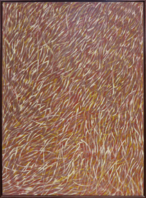 Federation University Art Collection
Painting - Artwork - painting, 'Grass Seeds' by Barbara Weir, 1999
Barbara Weir (b. 1945-03/01/2023) Born: In the region of Utopia, North East of Alice Springs, formerly known as Derry Downs Station Language: Anmatyerre and Alywarr Country: Atnwengerrp, Utopia Region, North East of Alice Springs, Northern Territory One of the Stolen Generation, Barbara Weir was removed from her Aboriginal family at the age of nine, and she was raised in a series of foster homes. Reuniting with her mother, Minnie Pwerle, in the 1960s, Weir eventually returned to her family territory of Utopia, 300 kilometres northeast of Alice Springs. Active in the local land rights movement of the 1970s Barbara Weir was elected the first woman president of the Indigenous Urapunta Council in 1985. Barbara’s career as an artist was inspired by the dynamic community of artists at Utopia and the work of her adopted auntie Emily Kame Kngwarreye. Highly experimental in her approach, Barabara Weir tried many mediums before travelling to Indonesia in 1994 with other artists to explore batik technique. She returned full of ideas on how to develop her own style which has since evolved to a more expressive abstract form. Grass Seed is part of her Dreamings and is associated with women’s ceremony and the activity of food gathering of local seeds, grasses, berries, potato, plum, banana, flowers and yams. This item is part of the Federation University Art Collection. The Art Collection features over 1000 works and was listed as a 'Ballarat Treasure' in 2007.Barbara Weir's paintings include representations of particular plants and "dreamings". Inspired by a small grass found in Utopia called Lyaw, Munyeroo or Pigsweed, Barbara's Grass Seed paintings consist of a series of small brush strokes that overlap and weave to create a swaying effect. This Dreaming tells the story of grass seed that is part of the bush tucker found in the region of Utopia. This seed is collected, crushed to a fine powder and is then used to make a bread, very similar to damper. The people of Utopia were still using this seed as late as the 1950s. During that time the seed grew in abundance but as the years passed there were very few good seeds to be found due to bullocks roaming the land and eating the grasses. The people then began to eat a substitute that the white man provided, and today very few Aboriginal people collect these seeds. art, artwork, barbara weir, aboriginal, dreaming, stolen generation, acrylic on linen -
 The Beechworth Burke Museum
Geological specimen - Olivine Crystals, Unknown
Olivine is mostly found on the Earth's surface in igneous rocks that are dark-coloured. It is common at divergent plate boundaries and at warm spots, such as volcanic areas. It crystalises and forms during the cooling of magma. Olivine is used in refractory sand, bricks, and gemstones. Olivine has been found on a number of meteorites, which might have originated from large asteroids or the mantle of a now-destroyed planet. This olivine crystal is thought to originate from Mount Noorat, with speculation that it could have originated from Mount Shadwell. Mount Noorat is a dormant volcano cone located in the Newer Volcanics Province of Victoria. Mount Noorat belongs to the Kirrae Wuurong people, who used the Mount as a place for meetings and gatherings prior to European settlement. Contact was first made between European settlers and the Indigenous people in 1841. The Mount has mostly been used for cattle and sheep grazing. Mount Shadwell is a well-known source of olivine and is the highest of a gathering of volcanic cones. The New Volcanic Province is located in South East Australia and covers 15000 square kilometres. It contains 400 explosive vents and small shield volcanoes. The last eruption is thought to have occurred 5000 years ago at Mount Gambier and Mount Schank. This olivine crystal has been identified as a volcanic bomb, which is a molten rock which was pushed out and ejected into the air when a volcano reupts. A rock needs to be larger than 65 mm in diameter to be classified as a volcanic bomb. This olivine volcanic bomb and its locality is historically and socially significant. The olivine was found in the Newer Volcanic Province, an area which contains over 400 dormant volcanoes. This olivine is one part of a volcanic bomb, which would have ejected when magma erupted out of a volcano. This specimen is part of a larger collection of geological and mineral specimens collected from around Australia (and some parts of the world) and donated to the Burke Museum between 1868-1880. A large percentage of these specimens were collected in Victoria as part of the Geological Survey of Victoria that begun in 1852 (in response to the Gold Rush) to study and map the geology of Victoria. Collecting geological specimens was an important part of mapping and understanding the scientific makeup of the earth. Many of these specimens were sent to research and collecting organisations across Australia, including the Burke Museum, to educate and encourage further study.A solid iron-magnesium silicate mineral with shades of green and brownburke museum, beechworth, geological, geological specimen, olivine, igneous rock, volcanic, gemstones, volcanic bomb, meteorites, asteroids, plantes, mount noorat, mount shadwell, indigenous, kirrae wuurong people, newer volcanics province, victoria, european settlement, eruption -
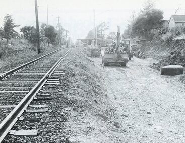 Ringwood and District Historical Society
Photograph, Duplication of the five-kilometre section of railway line between Ringwood and Croydon in 1983
Digital scanFrom Vicrail News magazine, April 1983. “Duplication of the five-kilometre section of line between Ringwood and Croydon is on the way. Several major works will be undertaken over the next few months so the two tracks can be brought into service later this year. Intensive work on this section follows completion of duplication works between Ringwood and Bayswater on the Belgrave line last December. The completion of this 5.17 kilometre section between Ringwood and Bayswater means that this Belgrave line is now duplicated as far out as Ferntree Gully. Commuters using the Belgrave line now have an improved service with the intro duction in January of an additional evening peak train to Upper Ferntree Gully, two additional peak hour services in the morning from both Belgrave and Upper Ferntree Gully, and with the additional tracks delays on one line will not affect trains travelling in the opposite direction. Commenting on the completion of this stretch of track the Minister of Transport, Mr. Crabb, said a further improvement had been made with the commissioning of boom barriers at the Bedford Road level crossing in Ringwood. "The installation is part of the State Government's $9.4 million four-year plan to equip 70 dangerous level crossings throughout the State with boom barriers", he said. Works to be carried out on the Ringwood/ Croydon section include laying of new track, station works at Croydon and installation of boom barriers at East Ringwood. Already completed are bridge works to cater for double tracks at both Mt. Dandenong and Eastfield Roads between Croydon and East Ringwood and construction of an island platform at East Ringwood station. At several locations alignment of the existing track will be slightly relocated. The new line is being constructed with concrete sleepers and heavyweight rails. The existing line will also be reconstructed using these heavy 60kg per metre rails. Engineering works to be completed include installation of overhead wiring necessary to supply power to trains, construction of two new station buildings and a new platform at Croydon, provision of boom barriers, and pedestrian boom barriers at Dublin Road level crossing. East Ringwood, and replacement of existing timber overhead wire support structures with steel structures. Other works in this program included installation of boom barriers at Bedford Road, Ringwood and Scoresby Road, Bayswater and provision of a new platform for trains going to Melbourne and Heathmont. A new timetable on the Lilydale and Belgrave lines will commence when the Ringwood—Croydon duplication track work is completed.” -
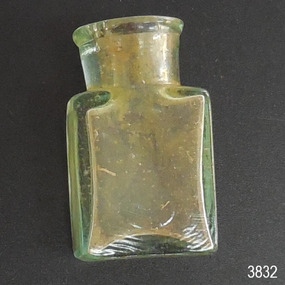 Flagstaff Hill Maritime Museum and Village
Container - Pill bottle, from mid-19th century to 1902
This small handmade bottle possibly dates from the mid-1840s. It may have been used as a traveller's ink bottle, due to its wide mouth. It was recovered from the wreck of the Inverlochy and is part of the John Chance collection. Small glass ink bottles similar to this one were handmade, blown into a cup shaped mould, and sharply broken off from the blow-pipe at the neck and sealed with a cork or wax. The mouth of this bottle appears to have been added after it was blown. INVERLOCHY 1895-1902 - The Inverlochy was a steel sailing barque built in Scotland in 1895 for international trade. In 1902 the Inverlochy left Liverpool under the command of Captain E.R. Kendrick. There were 21 officers and crew and the captain’s wife Mrs Kendrick, on board, bound for Australia with cargo that included tools, chemicals, liquor (beer, whisky, stout, rum, and brandy), steel, iron, wire netting, hoop iron, tinplate and pig iron), and steel wire for the Melbourne Tramway Company, tiles, soap, soft goods and earthenware. On December 18 almost at their destination, the Inverlochy ran aground on Ingoldsby Reef at Point Addis, near Anglesea. The crew and passengers left the ship via lifeboat and landed at Thompson’s Creek, then walked about 20 kilometres to Barwon Heads. Salvagers were interested in the 10 miles of cable in the hold. Mrs Kendrick’s ‘high grade’ bicycle was amongst the items salvaged but she lost her jewellery and two pianos. By February 1903 the ship had broken up and objects such as bottles and casks of liquor were washed ashore. Bad weather shook the wreck in June 1903, causing the ship’s spars and figurehead to be washed ashore. This handmade bottle is historically significant for its association with being made and used during the mid-to-late 19th century. This handmade glass bottle is significant for its connection with the John Chance Collection, which is historically significant as an example of artefacts from wrecks that had been lost in the coastal waters of Victoria from thirty to over one hundred years before John Chance and others discovered them. These artefacts are a sample of goods carried as cargo or personal possessions, and of ship hardware of that era. The bottle is significant through its connection with the barque, Inverlochy, The Inverlochy is significant for its cargo, which is a snapshot of the array of goods imported into Australia at the turn of the 19th century, including cable for the Melbourne Tramway Company. The Inverlochy is historically significant and is registered on the Victorian Heritage Database, VHR S338. The wreck of the Inverlochy is important as an accessible dive site that shows the remains of a large international trading vessel and its contents. It is valuable for an insight into Victorian era of shipping and maritime history.Bottle, clear glass, handmade, mould-blown. Small pill bottle has round mouth and neck, straight sides, rectangular base, no seams, shiny surface. Thickness of glass varies. Mouth is lop-sided and lip varies in width. Inscription of logo on both wide sides. Inscription embossed on sides [tear drop] logo. flagstaff hill, warrnambool, flagstaff hill maritime museum, maritime museum, shipwreck coast, flagstaff hill maritime village, great ocean road, john chance, inverlochy, scotland, captain e.r. kendrick, melbourne tramway company, tramway cable, ingoldsby reef, point addis, anglesea, thompson’s creek, barwon heads, victorian, antique, handmade, mould blown, small glass bottle, rectangular glass bottle, pill bottle -
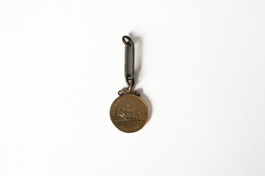 Chiltern Athenaeum Trust
Medal
This medal from the estate of W.C. Busse is believed to have been awarded to a recipient at the Rutherglen Agricultural Show in 1885. Due to degradation of the embossed markings, it is uncertain what the medal was awarded for or whom it was awarded to. It may have been awarded to a member of the Busse family prior to W.C. Busse's birth. Rutherglen is located approximately 18 kilometres from Chiltern. European agriculture and horticulture in the area was well established prior to the discovery of gold in the region in the 1860s. It held its first yearly Agricultural Show in 1880; in the present day it has a sister event focusing on showcasing the region's wines. Wilfred Clarence Busse was born in Chiltern in 1898. He went to school at Wesley College in Melbourne, studied law at the University of Melbourne and became a barrister. Additionally, after spending time on a Victorian station in his early twenties, he wrote two historical novels about bush life. His first novel was 'The Blue Beyond: a Romance of the Early Days in South Eastern Australia', written in 1928 and published in 1930. Busse's second novel was titled 'The Golden Plague: A Romance of the Early Fifties'. The judges of the Henry Lawson Society's T.E. Rofe competition to advance Australian literature unanimously awarded it the Gold Medal in 1931 for the best historical novel of 1930. Newspaper articles about the award mention the writer's meticulous documentary and oral history research regarding life on the Gold Fields in the 1850s. It became a best-seller. Busse also wrote a series of articles about local history for "The Federal Standard" newspaper in Chiltern. He was a member of the Chiltern Athenaeum. He died in 1960. This item is significant for the information it provides about the development of industry and local culture in Victoria in the 1880s. Bronze coloured medal attached to single large-format chain link; embossed medal markings are indistinct but appear to show Coat of Arms on reverse side. Inscription on obverse: Illegible Indistinct inscription on reverse may read: Rutherglen Agricultural Society medal, rutherglen agricultural show, chiltern, north-east victoria, gold fields, gold mining, gold rush, 1885, heirloom, farming, horticulture, rutherglen historical society, indigo shire, wilfred clarence busse, golden plague, authors, writers, victorian writers, victorian literature, historical fiction, blue beyond, wesley college, federal standard -
![Scene near Corranderrk Station / [by] Nicholas Caire, circa 1876](/media/collectors/550653872162f11fb04854aa/items/57774ae0d0cdd10a5c12f2d7/item-media/57774b61d0cdd10a5c132dac/item-fit-380x285.jpg) Kew Historical Society Inc
Kew Historical Society IncPhotograph, Anglo-Australasian Photographic Company, Scene near Corranderrk Station, c. 1876
Nicholas Caire was born on Guernsey in the Channel Islands in 1837. He arrived in Adelaide with his parents in about 1860. In 1867, following photographic journeys in Gippsland, he opened a studio in Adelaide. From 1870 to 1876 he lived and worked in Talbot in Central Victoria. In 1876 he purchased T. F. Chuck's studios in the Royal Arcade Melbourne. In 1885, following the introduction of dry plate photography, he began a series of landscape series, which were commercially successful. As a photographer, he travelled extensively through Victoria, photographing places few of his contemporaries had previously seen. He died in 1918. Reference: Jack Cato, 'Caire, Nicholas John (1837–1918)', Australian Dictionary of Biography. The 1860s marked the beginning of the era of reserves and missions. Six Aboriginal reserves were established during the 1860s. These were under the control of the Board for the Protection of Aborigines. Four were Christian missions receiving government aid. These were Lake Tyers (Anglican) and Ramahyuck (Presbyterian/Moravian) in eastern Victoria for the Gunai/Kurnai clans; Ebenezer (Moravian) in north-west Victoria for the clans of the Wimmera and Lower Murray; and Lake Condah (Anglican) in south-west Victoria. The other two were secular government controlled reserves: Framlingham which, like Lake Condah, was established for the Mara-speaking Gunditjmara and Kirrae-wurrung people of south-west Victoria; and Coranderrk, located about 60 kilometres north-east of Melbourne, for the Kulin clans of central Victoria. In 1863, after a period of devastation to the Kulin people, Coranderrk was established at the junction of the Yarra River and Badger Creek. Reference: http://coranderrk.com/, accessed 24 December 2016An original, rare photograph from the series 'Views of Victoria: General Series' by the photographer, Nicholas Caire (1837-1918). The series of 60 photographs that comprise the series was issued c. 1876 and reinforced a neo-Romantic view of the Australian landscape to which a growing nationalist movement would respond. Nicholas Caire was active as a photographer in Australia from 1858 until his death in 1918. His vision of the Australian bush and pioneer life had a counterpart in the works of Henry Lawson and other nationalist poets, authors and painters.Albumen silver photograph mounted on boardprinted in ink on support l.c.: SCENE NEAR "CORRANDERRK" STATION. / COPYRIGHT REGISTERED. printed in ink on support reverse c.: VIEWS OF VICTORIA. / (GENERAL SERIES.) / No. 9. / SCENE NEAR "CORRANDERRK" STATION. / This scene was taken from the hill near Rourke's Bridge, on the Healesville Road, and displays in the foreground / the River Yarra. The roadway which is seen in the mid-distance has lately been constructed by the Government, / as the old tracks which formerly existed, were liable to be swamped by the periodical overflowing of the River. Mount / Ridell can be seen in the extreme distance immediately behind the roadway. / Corranderrk is the local habitation / for the natives of this district, and is situated on the right hand side of the picture, about a mile and a half / from the roadway. printed in ink on support reverse l.c.l.: J.W. FORBES, Agent, printed in ink on support reverse l.c.: ANGLO-AUSTRALASIAN PHOTOGRAPHIC COMPANY, MELBOURNE. printed in ink on support reverse l.c.r.: 10 Temple Court, Collins Street West.nicholas caire (1837-1918), coranderrk aboriginal station, aborigine, yarra river, badger creek, first peoples, aboriginal and torres straight islander -
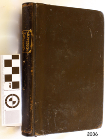 Flagstaff Hill Maritime Museum and Village
Book - Textbook, Introduction to Modern Geography
This mid-19th century scientific reference book, Introduction to Modern Geography, explains geography and astronomy using the globe of the world as a teaching aid. The inscription connects this book to the Bobinawarrah Public Library but research to date has found no further details about the library. The rural area was settled in 1859, but in 2016 its population was only 87. It is situated about 21 kilometres south of the City of Wangaratta, in Northeast Victoria. In 2024 the local community received a grant for preservation of its almost 100-year-old Bobinawarrah Memorial Hall which displays an honour board of the Pioneers of Bobinawarrah 1859-1959. The donor of the book lived in Warrnambool. ABOUT THE AUTHOR, James Thomson (1786-1849): - James Thomson was a British Irish mathematician. He became Professor of Mathematics at the University of Glasgow. He wrote many school textbooks and reference books, one of which was Introduction to Modern Geography, first published in Belfast in 1827, and revised and published in over 20 more editions. Thomson tutored two of his several children at home. His older son James Thomson (1822-1892) became an engineer and physicist. His younger son William Thomson (1824-1907) became Professor of Natural Philosophy from 1846-1899 at the University of Glasgow, and later the 1st Baron of Kelvin, famous for his designs of nautical instruments such as the navigational compass and sounding equipment used in the transatlantic installation of sea cable. William was part of the firm that became famous as Kelvin & Hughes Ltd., suppliers of radar and echo sounders to the Ministry of Transport and the Ministry of Defence. The name continued on as Kelvin & Hughes. James Thomson (1786-1849) was a renowned British Irish mathematician and Professor of Mathematics at the University of Glasgow. He was a respected author of many important school books and textbooks that were widely used to provide understanding of arithmetic and geography. Thomson encouraged practical education and held extra classes for young ladies to learn mathematics and geography, which were a novelty at that time. Many of his works were known and used worldwide. This work was published in many editions. It is now considered as culturally significant as a basis for knowledge about our civilisation and has been made publicly available in overseas countries, and republished and reproduced in a readable format, including its diagrams and maps. Book; scientific textbook. The book has a black leather cover. The front cover is blank, but the spine has an embossed gold vertical title within a rectangular border boasting fancy corners. The fly page has a detailed title. The author is James Thomson. It is the Eighteenth edition, published in Simms & McIntyre of London and Belfast in 1845. An inscription connects it to the Bobinawarrah Public Library in Victoria.Spine within a gold border: "THOMSON'S GEOGRAPHY" Fly Page: "AN INTRODUCTION TO MODERN GEOGRAPHY, WITH AN APPENDIX, CONTAINING AN OUTLINE OF ASTRONOMY, AND THE USE OF THE GLOBES. BY JAMES THOMSON, LL.D., PROFESSOR OF MATHEMATICS IN THE UNIVERSITY OF GLASGOW." "Eighteenth Edition" "LONDON: SIMMS AND McINTYRE, ALDINE CHAMBERS, PATERSOSTER ROW; AND DONEGALL -STREET, BELFAST.""1845"flagstaff hill, flagstaff hill maritime museum and village, warrnambool, maritime museum, maritime village, great ocean road, shipwreck coast, introduction to geography, james thomson, reference book, professor thomson's introduction to modern geography, bobinawarrah public library, james thomson mathematician, james thomson engineer, 19th century irish mathematician, irish presbyterian, william thomson 1st baron of kelvin, professor of mathematics, glasgow university, william thomson professor of natural philosophy, introduction to modern geography, outline of astronomy, use of the globes, james thomson ll.d., simms and mcintyre, 1843, scientific book, school book, lord kelvin, baron kelvin of langs, nautical instruments, marine instruments, transatlantic cable, kelvin & hughes, thomson’s geography, astronomy, geography, world globe, cartography, pioneers of bobinawarrah, textbook -
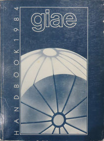 Federation University Historical Collection
Book, Gippsland Institute of Advanced Education Handbooks, 1970-1985
.1) 1977 Gippsland Institute of Advanced Education Handbook with white cover .2) 1978 Gippsland Institute of Advanced Education Handbook with blue/black cover .3) 1979 Gippsland Institute of Advanced Education Handbook with orange cover .4) 1980 Gippsland Institute of Advanced Education Handbook with yellow/brown cover .5) 1981 Gippsland Institute of Advanced Education Handbook with grey/black cover .6 1984 Gippsland Institute of Advanced Education Handbook with blue cover .7) 1985 Gippsland Institute of Advanced Education Handbook with purple cover .8) 1989 Gippsland Institute of Advanced Education Handbook with white/purple/grey/red/blue cover .7) 1985 Gippsland Institute of Advanced Education Handbook with pale green cover. .9) 1974 Gippsland Institute of Advanced Education Handbook with orangeand white cover .10) 1975 Gippsland Institute of Advanced Education Handbook with green and white cover .11) 1976 Gippsland Institute of Advanced Education Handbook with white cover .12) 1986 Gippsland Institute of Advanced Education Handbook with mid-blue cover .13) 1987 Gippsland Institute of Advanced Education Handbook with red cover .14) 1988 Gippsland Institute of Advanced Education Handbook with red cover .15) 1973 Gippsland Institute of Advanced Education Handbook with brown cover .16) 1972 Gippsland Institute of Advanced Education Handbook with pale green cover .17) 1971 Gippsland Institute of Advanced Education Handbook with mid-blue cover non-fictiongippsland institute of advanced education, giae, gippsland, churchill, morwell, electricty, handbook, gippsland campus -
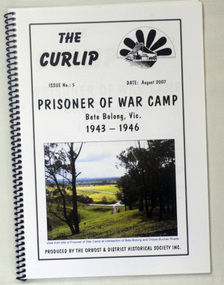 Orbost & District Historical Society
book, The Curlip - P.O.W.Camp Bete Bolong, Vic. 1943-1946, August 2007
This is Issue No. 5 of "The Curlip". The magazine is a compilation of research from a trip by the Orbost & District Historical Society to Bete Bolong. The Bete Bolong Prisoner of War Camp was located on the south side of the Buchan - Orbost Rd. From November 1943 to November 1945, Italian prisoners of war were based at Bete Bolong, cultivating maize, peas, beans and other vegetables on local farms. Unlike other 'farming' prisoners of war, those at Bete Bolong did not live with the farming families, but at a Prisoner of War Control Centre on Crown land overlooking the Snowy River Flats. About fifty Italian prisoners lived at the centre, along with an Australian Military Force staff of approximately seven people. The prisoners were driven to and from the farms each day. Three of them apparently simply swam across the river to work. They worked a six day week, with Sundays off. Although they were provided with rations, both prisoners and staff maintained vegetable and flower gardens. They were also skilled at cooking 'anything' they could catch, and at making illegal "grappa". Very few of the Italians were experienced farm workers. Some of them used their skills to make things for the families they worked for; a cabinet-maker made furniture , a cobbler made shoes, etc. They interacted with the local community and, although they were not supposed to go within one kilometre of town, some were found at local dances on Saturday nights. As recreation the prisoners were allowed to walk along the road to the west of the camp. Local people from both sides of the river could hear them sing as they walked. The prisoners also helped to construct an 'ant bed' tennis court on a property adjacent to the centre. Although now overgrown, the site of the tennis court can still be discerned as a flat area above the site of the centre. (ref./vhd.heritagecouncil.vic.gov.au)This item is a useful reference tool on the history of the Prisoner of War Camp at Bete Bolong, Orbost.A spiral bound book with a clear plastic cover. On the front is a coloured photograph of a view from the site of the P.O.W. camp at the intersection of Bete Bolong and Buchan Roads at Bete Bolong. Above is the title "Prisoner of War Camp Bete Bolong, Vic. 1943-1946" in black print on a white background. p.o.w.-camp-orbost ww11 bete-bolong