Showing 10891 items
matching land
-
 Ringwood and District Historical Society
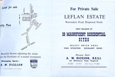
Document - Folder, Land Sale - Leflan Estate, North Ringwood, Vic. - circa 1967
Bi-fold land sale advertisements for stages 1 and 3 releases of residential allotments in Leflan Estate, Ringwood North, circa 1965-1967. Brochures include area map, layout of the estate, and summary of local facilities and services, with separate attachment listing lot number prices for 2nd and 3rd releases.Subdivision includes Melview Drive, Leslie Grove, Leflan Close, Warrandyte Road and Lockhart Street. Agent - A.W. Dickson, R.E.S.I., 136 Whitehorse Road, Ringwood. (Phone) 870-6007, 870-7016, After hours 870-6868. -
 Ringwood and District Historical Society
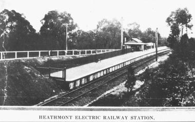
Photograph, Heathmont Railway Station, 1926. Image taken from a land sale brochure advertising Charm-View Estate Sub-division opposite the station
Black and white photographs (2 copies - same size)Written under photograph - HEATHMONT ELECTRIC RAILWAY STATION. Written on back of photograph, "Photo taken from Sub. Div. Land Sale - Heathmont Electric Railway Station right opposite Estate. Charm-View Estate. Heathmont (For private Sale), 1926?" -
 Ringwood and District Historical Society
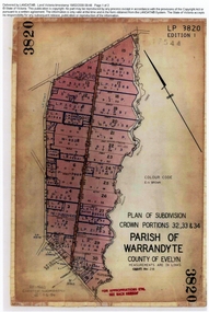
Document, Titles of land subdivision, Crown Portions 32, 33 & 34, Parish of Warrandyte, 1884 and 1907, Ringwood, Victoria
Evolution of the subdivision and the use of landBlack plastic bound pockets containing copies of 18 LANDATA subdivision maps and mortgage transfer pages dating from 1884 for 303 acres 2 roods and 1 perch bounded by Warrandyte Road, Wonga Road, Oban Road and Mullum Mullum Creek in Ringwood, Victoria. Certificates of Title include Vol 1606 Fol 045 Frederick Walter Purches 1884 and subsequent transfers to 1902, and Vol 3232 Fol 646357 Ann Jane Kennedy 1907 and transfers to 1921. -
 Ringwood and District Historical Society
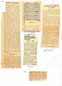
Newspaper, Newspaper articles detailing the acquisition of 40 acres of land for Jubilee Park, formerly known as Sanders Estate, for recreation purposes
Various newspaper articles about detals of the acquisition, by Ringwood Council, of 40 acres of land for Jubilee Park, formerly known as Sanders Estate, for recreation purposes in 1945-1959. The area included named streets - Prussia Road (not West Prussia Road), Duffy Street, Ireland Street, Evens Street and Chapman Street. -
 Tatura Irrigation & Wartime Camps Museum
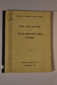
Book, Soils and Land Use, 1963
Advice to land holders on how to use the Soil Survey Report. Soils and land use in the deakin Irrigation area, Vict, Technical Bulletin No. 16, Melb. Includes maps for Deakin Irrigation AreaCream cover, black writing, Techical Bulletin No. 16soils and land use, tatura, irrigation, books, technical, rural, industry -
 Flagstaff Hill Maritime Museum and Village
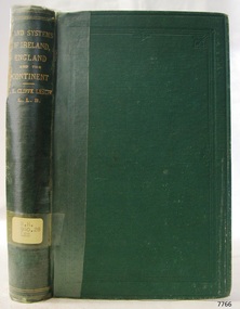
Book - Reference Book, T E Cliffe Leslie (Thomas Edward Cliffe Leslie), Land Systems and Industrial Economy, 1870
The inscription "David Evans, Timor St., June 1875" is assumed to be the previous owner, perhaps a donor to the Old Warrnambool Library. The book is part of Flagstaff Hill's Pattison Collection. The author, Thomas Edward Cliffe Leslie (1825 – 1882) was an Irish jurist and economist and was the Examiner in Political Economy in the University of London, and a Professor in Queens University in Ireland and Queen's College, Belfast. The book was published by Longmans Green and Co of London. The publisher firm, Longmans, Green & Co, was originally founded in 1724 in London by Thomas Longman under the name Longman. In August of that year, he bought the two shops and goods of William Taylor and set up his publishing house there at 39 Paternoster Row. The shops were called Black Swan and Ship, and it is said that the 'ship' sign was the inspiration for Longman's Logo. After many changes of name and management, the firm was incorporated in 1926 as Longmans, Green & Co. Pty Ltd. The firm was acquired by Pearson in 1968 and was known as Pearson Longman or Pearson PLC. The book is significant for its connection to the publisher Longmans, Green and Co., of London, a firm that has been established for over two centuries, renowned for publishing encyclopedias, dictionaries, books on English grammar, textbooks, poetry, reference books, novels, magazines and more. The book has additional importance for its connection to the Pattison Collection, which, along with other items at Flagstaff Hill Maritime Village, was originally part of the Warrnambool Mechanics' Institutes’ Collection. The Warrnambool Mechanics’ Institute book collection has historical and social significance for its strong association with the Mechanics Institute movement and its important role in people's intellectual, cultural and social development throughout the latter part of the nineteenth century and the early twentieth century. The collection of books is a rare example of an early lending library and its significance is enhanced by the survival of an original collection of many volumes. The Warrnambool Mechanics' Institute’s publication collection is of both local and state significance.Land Systems and Industrial Economy of Ireland, England, and Continental Countries Author: T E Cliffe Leslie Publisher: Longmans Green and Co Date: 1870 Green cloth hardcover book with gold embossed text on the spine. Part of the Pattison Collection. Inscriptions on label, stickers and fly page. Inscription with name and date in pencilHandwritten in pencil on endpaper: "David Evans, Timor St., June 1875" Label typed "RH 940.28 LES" Sticker "Warrnambool Mechanics Institute and Free Library" Stamp "Withdrawn from circulation from Warrnambool Public Library." Handwritten on fly: "(crossed out) 191", "M" "201" "4)flagstaff hill, flagstaff hill maritime museum and village, warrnambool, maritime museum, maritime village, great ocean road, shipwreck coast, pattison collection, ralph eric pattison, warrnambool mechanics’ institute, mechanics’ institute library, warrnambool library, free library, corangamite regional library service, longmans green and co. london, land systems and industrial econom, t e cliffe leslie, thomas edward cliffe leslie, 1870, edonomy, politics -
 Greensborough Historical Society
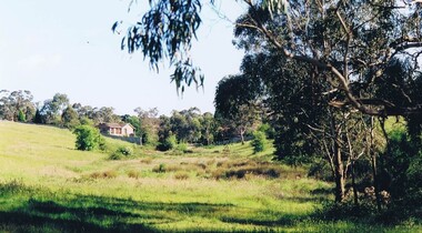
Photograph - Digital image, Frank Solomon, Open land Greensborough, 1990c
A patch of open land in Greensborough circa 1990Digital copy of colour photographbriar hill, greensborough -
 City of Ballarat Libraries
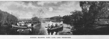
Postcard - Card Box Photographs, Boating on Fairy Land, Lake Wendouree 1910
Evening Shadows, Fairy Land, Lake Wendoureefairy land, lake wendouree, boating, vehicle, people -
 Ballarat Diocesan Historical Commission
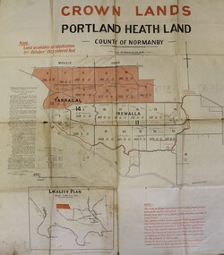
Poster, Government Land Sales Poster
Government poster advertising land sales to promote closer settlement in Portland area. The acquisition of land for the purpose of closer settlement was first authorised under the provisions of the Land Act 1898. In 1917 under the provisions of the Discharged Soldiers' Settlement Act, the scheme reverted to the Soldiers' Settlement scheme when the government undertook the settlement of discharged soldiers on lands set aside exclusively for them as a reward for their war service.closer settlement, soldiers settlement, government poster. land sales, portland. -
 Ringwood and District Historical Society
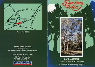
Flyer, Land Auction Brochure - Thackray Wood, Ringwood East - circa 1984
Double sided bi-fold sales brochure regarding sale of 14 blocks of land comprising Thackray Wood, corner Cheong Street and Ruthven Way, Ringwood East. Agent: Max Brown Real Estate, 53 Main Street Croydon, Tel 7230281 a.h. 8764034. Inset image of additional copy with handwritten sale prices. -
 Federation University Historical Collection
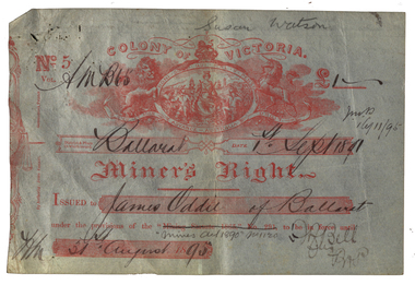
Document - Miner's Right, Colony of Victoria, Miner's Right for the Ballarat Observatory Land in Magpie Street, 1890-1899
The Ballarat Observatory was established by James Oddie. It was later given to the Ballarat School of Mines, then the City of Ballarat.A number of Miners' Rights made out to James Oddie of Ballarat, for a block of land in Magpie Street, Mount Pleasant, used as the Ballarat Observatory. The red 1995 Miners' Right includes land at Dana Street with red writing over it regarding its transferal. The Observatory Registration in No 19578 with the situation of residence area being 'Magpie Street Mount Pleasant 209 feet x 52 feet" The District and Division is Central D Ballarat. The red Miners' Right includes the Magpie Ste Address and "Dana Street allot 3 Sec 52 40 feet and 140 feet in Ballarat Central D". In red ink over the address in written (Ressarell) transferred in favor of Susan Watson 7/1/95 C.H. Stevenson Asst M.R. miner's right, james oddie, ballarat observatory, magpie st, mount pleasant, f. bell, w.a. christy, dana street -
 Tatura Irrigation & Wartime Camps Museum
Book, Soils and Land Use. Deakin Irrigation Area Technical Bulletin No 16, 1963
Mid sized soft cover book, black spine, off white front and back, black writing on back and frontnon-fictionland use, soil use, deakin irrigation area -
National Wool Museum
Book, The romance of the Australian land industries
"The romance of the Australian land industries" - R D Watt, 1955.agriculture pastoral industry - history sheep breeding - history sheep stations - history woolclassing agricultural societies agriculture - environmental impact, agriculture, pastoral industry - history, sheep breeding - history, sheep stations - history, woolclassing, agricultural societies, agriculture - environmental impact -
 Ringwood and District Historical Society
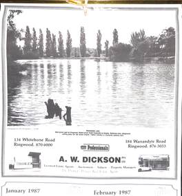
Souvenir - Complimentary A.W.Dickson Real Estate Agents calendars, Complimentary A.W.Dickson Real Estate Agents calendars - 1987 and 1988.1987 calendar with photographic images of local Ringwood features and 1988 calendar featuring local Ringwood land sale promotional images from early 20th Century
A.W.Dickson was a Real Estate Agent in Ringwood for many years. These calendars show the local buildings of the day. For example the original Eastland 's building of 1967, Maroondah Hospital 1976 and the Civic Centre now the Karralyka Centre.1 1987 calendar with six black and white photos of buildings and vistas around Ringwood with monthly dates in lower quarter of page. 2 1988 calendar with six posters advertising early 20th century land sales in Ringwood, Heathmont and Ringwood East with dates in lower quarter of page Compiled by A.W.Dickson Pty. Ltd. Real Estate Agent. Photographed by C.M.S. Photographers - 725 9441 (January February 1987) RINGWOOD LAKE - Ideal picnic spot for Ringwood Model power boats frequently on display. Barbecue area, playground, resting place for old steam engine. Yabbie netting is a favourite pastime here. (March April 1987) CLOCK TOWER - Moved from its former site on Warrandyte Road corner in 1967 and re-built in its present location, brick by brick. A wreath laying ceremony is held here on Anzac day each year. (May June 1987) RINGWOOD AQUATIC CENTRE - A world class swimming facility opened in 1986 at a cost of $3 million. Featuring the latest ozone water treatment techniques. In summer folding doors can be opened to give access to existing outdoor pools and sunbathing area. (July August 1987) MAROONDAH HOSPITAL - Opened in 1976 after many years of fund raising efforts by local people. The opening of casualty facilities was welcomed by locals as previously Box Hill Hospital catered for the entre area. (September October 1987) EASTLAND - Opened October 1967. Built on a former football oval. Now about to undergo major extensions to cater for Ringwood's population growth into the 21st Century. November December 1987 CIVIC CENTRE - Built on the site of a former antimony mine behind the council offices. Now the venue for many activities and a local point for Ringwood's Cultural Life. -
![Plan, University of Melbourne Burnley Campus Institute of Land and Food Resources Formerly known as the Royal Horticultural Gardens Burnley [sic], 2001](/media/collectors/52f2d90c9821f4163875a333/items/6145823c174069677c22f6e6/item-media/65ef8feeb2201fddf6999498/item-fit-380x285.jpg) University of Melbourne, Burnley Campus Archives
University of Melbourne, Burnley Campus ArchivesPlan, University of Melbourne Burnley Campus Institute of Land and Food Resources Formerly known as the Royal Horticultural Gardens Burnley [sic], 2001
site plan, buildings, planrs -
Tatura Irrigation & Wartime Camps Museum
Document, irrigable land in Ardmona
Pages of "Eshcol" proposal to subdivide irrigable land in Ardmona, late 19th. Century. -
 University of Melbourne, Burnley Campus Archives
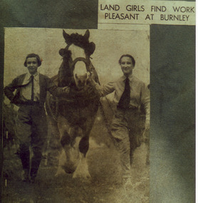
Photograph - Colour print, The Argus, Land Girls Find Work Pleasant at Burnley, 1937-1990
Photograph probably 1937, taken by A.P. Winzenried as a possible illustration for,"Green Grows Our Garden." Colour photograph. Copy of a newspaper article in, "The Argus," probably 1937, taken by A.P. Winzenried. Caption reads," Land Girls Find Work Pleasant at Burnley. Farm work appears to be a pleasant task for these girls photographed yesterday at Burnley Horticultural College. The plough horse is being returned to the stable after a day's work in the orchard." 2 girls leading Don, the draughthorse.Handwritten underneath, "M. Atkins, Don, J. Wakeford."a.p. winzenried, green grows our garden, female students, orchard, m. atkins, don, j. wakeford, donald, horse, land girls, students working outside, draughthorse, newspaper cutting -
 Greensborough Historical Society
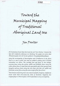
Booklet, Toward the municipal mapping of traditional aboriginal land use, by Jim Poulter, 2017c
Using Manningham as an example, aboriginal land use patterns are shown, together with interconnecting songlines.10 p., typescriptmanningham, songlines, aborigines -
 Ringwood and District Historical Society
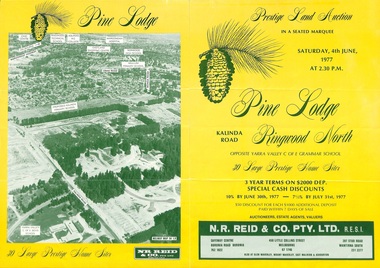
Flyer, Land Auction Sale Brochure, Pine Lodge, Ringwood North, Victoria - 1977
Refer also to Reg. No. 5172 for Pine Lodge Land Auction 3rd release, 1978.Yellow double-sided real estate auction notice with green print showing aerial photograph and map of subdivision layout and summary of local features and services for Pine Lodge, Kalinda Road, Ringwood North. Auction date, Saturday, 4th June, 1977, at 2:30pm.Subdivision plan includes Parkgate Drive, Wood-Church Close, and Pensby Court. (Agent) N.R. Reid & Co. Pty. Ltd., Safeway Centre, Boronia Road, Boronia (Phone) 762 1022, 450 Little Collins Street, Melbourne (Phone) 67 1746, and 207 Stud Road, Wantirna South (Phone) 231 2277. -
 Ringwood and District Historical Society
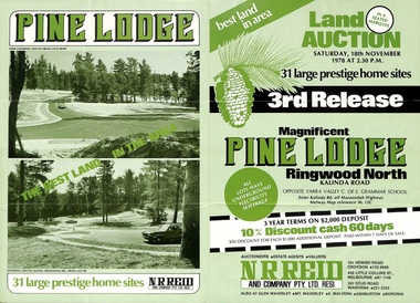
Flyer, Land Auction Sale Brochure, Pine Lodge, Ringwood North, Victoria - 3rd Release 1978
Refer also to Reg. No. 5171 for Pine Lodge Land Auction previous release, 1977.Green tri-fold advertisement for auction of home sites, with map of subdivision, photographs, and summary of local features and services for Pine Lodge, Kalinda Road, Ringwood North - 3rd release - Auction date, Saturday, 18th November, 1978, at 2:30pm.Subdivision plan includes Mundara Drive, Bidston Court, Parkgate Drive, Frodsham Road, and Bebington Close. (Agent) N.R. Reid & Co. Pty. Ltd., 10A Hewish Road, Croydon (Phone) 725 0999, 450 Little Collins Street, Melbourne (Phone) 67 1746, and 207 Stud Road, Wantirna South (Phone) 221 2222. -
Clunes Museum
Book, ROBERT BELL AND ASSOCIATES P/L BALLARAT, LIST OF THOSE WHO PURCHASED LAND AT AUCTION IN BUNINGYONG 1851-1856, 2001
HISTORICAL TRANSCRIPTION AND COMPLATION OF LAND PURCHASED AT BUNINYONG MID 1800'SORANGE COVERED BOOKLET WITH THE TITLE PRINTED ON THE FRONT COVERnon-fictionHISTORICAL TRANSCRIPTION AND COMPLATION OF LAND PURCHASED AT BUNINYONG MID 1800'Slocal history, book, buninyong -
 National Wool Museum
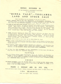
Brochure, "Binda Vale" Toolamba land and stock sale
"Binda Vale" Toolamba land and stock sale Monday November 28" Leo Kearneypastoral industry - history, binda vale, toolamba -
 Ballarat Heritage Services
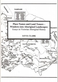
Book, Place Names and Land Tenure: Windows into Aboriginal Landscapes: Essays in Victorian Aboriginal History
Place Names and Land Tenure was published by BHS Publishing and written by Ian D. Clark. -
 Ringwood and District Historical Society
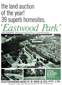
Document - Folder, Eastwood Park Subdivision, Ringwood East, Vic. - Land Sale Circa 1967 - Site of former Eastwood/Eastfield Golf Course
Subdivision is advertised as including homesites on former Eastwood Golf Course fairways and land contours.Collection of subdivision maps, and double-sided advertisement for auction sale on Saturday, April 22nd, 1967, with summary of local features and services. Subdivision includes Croydon South streets, Andrew Crescent and Banksia Court. Agents - N.R. Reid & Co Pty Ltd, 173 Coleman Parade, Glen Waverley, Tel. 560 0355 A.H. 232 8423.Handwritten sales notations include "Vendor - Willcroft Development P/L 54-60 Southern Road Mentone Tel 93-1267 (Mrs. Morley). Lot 19 $5200, Lot 25 $4500, Lot 28 $3800, Lot 29 $3700, Lot 30 $3600. $400 deposit balance 3 yrs @ 7% $40 per month. All C/S to be prepared by vendor. 5% discount for cash." -
 Eltham District Historical Society Inc
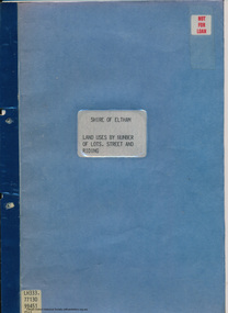
Document - Folder, Shire of Eltham, Land uses by number of lots, street and riding, 1984
In work undertaken by the Shire of Eltham in revising its residential multi-unit development policy, information was collated by street and number of units. The exercise was expanded to include other land uses. At the end of each Riding is given a summary of the number of the various major land uses and index to abbreviations used on the last page11 pages inside blue coverharry gilham collection, land use, streets, ridings, dwellings, units -
 Bendigo Historical Society Inc.
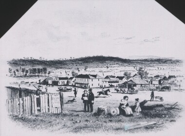
Negative - TOM PATULLO COLLECTION: GOV. SALE, LAND
Negative print. Gov. Sale of Land, image shows some buildings in background, Govt. land sale advertisement on fence LH side.cottage, miners, gov. sale, land, gov. sale, land -
 Bacchus Marsh & District Historical Society
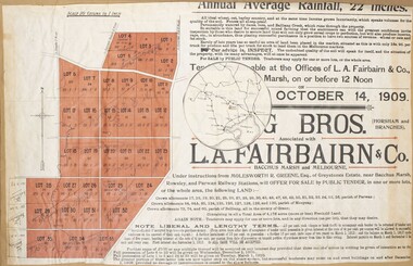
Map, Greystones Estate Land Sale 1909
This map was produced sometime around mid 1909 to advertise portions of land from the Greystones Estate for sale by public tender. The selling agents were Young Brothers of Horsham and L.A. Fairbairn of Bacchus Marsh and Melbourne. The seller was Molesworth R. Greene who was a pioneer pastoralist in the Bacchus Marsh area and had also acquired other properties in Victoria and interstate. Molesworth Greene died in 1916 so this sale came towards the end of his life. A total of 4,176 acres was offered for sale in multiple lots. Successful tenderers could buy single or multiple lots. The results of the sale were reported in the Bacchus Marsh Express newspaper on the 16th October 1909, page 3. At the sale a total of 3, 420 acres was sold. A single page paper map showing portions of land for sale from the Greystones Estate near Bacchus Marsh. The map includes extensive details about the property, number of allotments for sale, terms and conditions of the sale and prices. The map includes an inserted reference map showing the location of the property in relation to Melbourne, Geelong, Ballarat and Castlemaine. The top of the map appears to be missing resulting in some loss of the text. The sale notice in the Bacchus Marsh Express of 10 July, 1909, page 3, column 1 appears to duplicate the text overall in the auction plan. Based on this the missing text is likely to be: "Important Subdivisional Sale 'Of Portion of One of the Best and Most Favourably known Estates IN THE RENOWNED BACCHUS MARSH DISTRICT. And situated only six miles from that prosperous township, two miles from Rowsley, and three miles from Parwan, all Railway towns, connected with the Estate by metal roads." Scale: 20 chains to 1 inch The map is pasted into a bound volume containing 76 maps or plans in total. bacchus marsh victoria maps, land sales, land sales bacchus marsh, greystones estate bacchus marsh, molesworth r. green 1827-1916, land sales rowsley -
 Kew Historical Society Inc
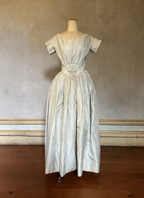
Clothing - Grey silk wedding dress, 1842
This wedding gown was worn by Mary Ann Lawrence at 8.00am on 5 January 1842 at St John's Church, Launceston, when she married Francis Henty. The couple were to catch the tide on their way to Portland two hours later. Francis Henty was the youngest son of Thomas Henty, who with his family, their retainers and property moved to the Australian colonies between 1829 and 1832. In 1834, Francis’ older brother, Edward, sailed from Launceston in Van Diemen’s Land to what was to become Portland in the western part of Port Phillip District [Victoria]. Francis, together with the first flock of Merino sheep [in Victoria], followed some months later. The first and second generations of the Henty family established vast pastoral properties in the Western part of the Port Phillip District. Francis Henty managed ‘Merino Downs’ near Casterton, while also living in his retirement at ‘Field Place' in Kew. The Henty Collection of nineteenth and twentieth century clothing, including outerwear and underwear, was collected, stored and exhibited over time by female family members descended from Francis and Mary Ann Henty. During the twentieth century, items from the collection were modelled in two fashion parades by various descendants [1937, 1959]. The items in the collection are historically and aesthetically significant, with provenance provided by oral and written tradition within or held by the family. A number of the items in the collection are very rare survivors, and provide researchers with the evidence needed to reconstruct the lives of notable women in the Port Phillip District [later Victoria] during the nineteenth and early twentieth century.Mary Ann Lawrence's grey silk wedding gown has a v-line waist and a partly smocked bodice. It is lined with muslin throughout. It has hand-tatted cotton lace and handmade piping around the neck and bodice and pleated short sleeves. There was originally trimming on the skirt which was removed at a later date. Orange blossom made of chamois and tiny coiled springs originally decorated the neckline. The outfit was complemented by a bonnet to which a Limerick lace veil was attached. Measurements (mm): Girth - Neck 914, Chest 812.8, Waist 660.4, Cuff 330.2, Hem circumference 3200.4. Vertical - Front neck to hem 1270, Front waist to hem 1016, Back neck to hem 1320.8, Back waist to hem 1041.4, Sleeve length 114.3. Horizontal - Neck to sleeve head 50.8, Chest back 406.4, Underarm to underarm 406.4.mary ann lawrence, francis henty, wedding dresses, fashion -- 1840s, women's clothing -
 Ringwood and District Historical Society
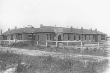
Photograph, Ringwood State School, Greenwood Avenue, Ringwood, on completion - 1922. Site was 3 1/2 acres of Count von Hariss' orchard. Land bought from A. Greenwood MLA"
Typed below photograph, "Ringwood State School - Greenwood Avenue on completion - 1922". Written on back of photograph, "1922 - Site was 3 1/2 acres of Count von Hariss(?) orchard. Land bought from A. Greenwood MLA". Identical framed photograph located in bookshelves -NWD 01-02-03 -
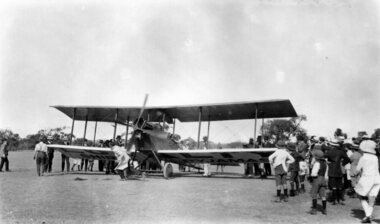 Nhill Aviation Heritage Centre
Photograph - Digital copy, First aircraft to land at Nhill in 1919, 1919
This is a copy of the only known photograph of the first plane to land at Nhill. Taken when landed on race course.This photo is significant because it is the only known photograph of the first plane to land at Nhill. A full description of theis event can be found in the Nhill Free Press Nov 1919.Digital Copy of Originalaircraft, airplane, biplane, 1919, first landing, nhill