Showing 629 items matching " land surveyed"
-
 Bendigo Historical Society Inc.
Document - BUSINESS LICENSE PETITION
Handwritten and typed copies of a Business License Petition. Petition is about storekeepers, etc. who have built their businesses on Crown Land. The petitioners hoped that the land upon which they have erected their premises may be surveyed and put up for public auction and that the premises on the land are valued and allowed for.document, names of bendigo pioneers, business license petition, business license petition, i hendry, major general macarthur -
 Bendigo Historical Society Inc.
Photograph - BENDIGO POST OFFICE 1854
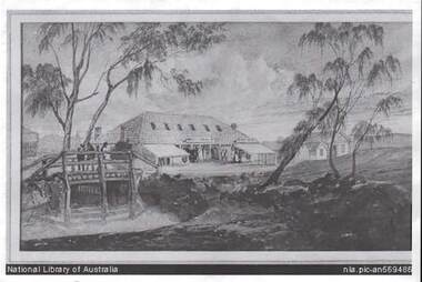
Photo: copy of photo of first Bendigo Post Office and Survey Office, located corner of Mitchell and Pall Mall. Building constructed by John Pyke, land purchased for 1800 pounds in first land sales. Source of information: Dr. Ralph Birrell. This reproduction is the property of the National Library of Australia, and is not for reproduction in any form apart from for research.bendigo, buildings, post office and survey office -
 Bendigo Historical Society Inc.
Photograph - WES HARRY COLLECTION: LAND OFFICE VIEW STREET
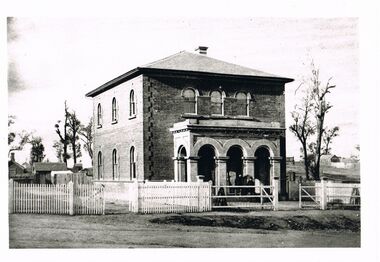
Black and white photo copy: image shows Survey office in View Street, known as Dudley House. Two storey brick building with verandah. Three arches in front portico facing street front. Picket fence on front of street, small buildings at rear.Batchelderplace, building, dudley house, bendigo, sandhurst, survey office, larritt, view street -
 Bendigo Historical Society Inc.
Document - NORMAN OLIVER COLLECTION: SPEECH NOTES FROM YEARS 1949-1971
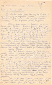
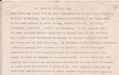
The Norman Oliver collection. Norman Oliver was three times Mayor of Bendigo - 1950-51, 1964-65, 1970-71. a) Seventeen pages of typed notes for a speech. Topics include : The story of the taxi cab, Your library, Regional library development, Land reclamation, Traffic control, A point about parking, Social (visit to Fortuna by Major General Brown Director of Ordnance survey, British Army), The historical society. Undated, but next to other notes marked 1951. b) a donation letter headed 'The Mayor Speaks' states: Herein are the texts of addresses given by the Mayor Cr N.J Oliver over Radio Station 3BO, together with other talks given by him. They were given to Alex H Stone by Mr Oliver on his leaving Bendigo. They are now handed by him to Bendigo Branch - Royal Historical Society of Victoria, as they are worthy of preservation. 26-3-1982 signed Alex H Stone.bendigo, council, speech notes, norman joseph oliver , councillor norman oliver, sometime mayor of bendigo. radio station 3bo 'the mayor speaks'. bendigo centenary 1951. -
 Bendigo Historical Society Inc.
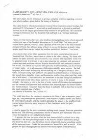
Document - PRESENTATION TO BHS 7TH JULY 2000: ''CAMP RESERVE'', 7th July 2000
Presentation by James Lerk to BHS 7th July 2000: ''Camp Reserve -Rosalind Park, used and abused''. First line: ''This short paper has no pretension in giving a complete synopsis regarding a slice of land which cradles a great deal of the history of Bendigo''. References to Commissioner Gilbert; Bank of Victoria; Bendigo Bank; powder magazine; post office; Survey Office; Court of Petty Sessions; Police Barracks; Supreme Court; Gaol; Temperance Society; Robert Strickland residence; tenements on Reserve; Mac's Track; Orderly Room; Cascades; Corporate High School; Temperance Fire Brigade; Masonic Hall; Central School Camp Hill; Fernery; ''The Willows''; Conservatory; Parade Ground; Sandhurst Club; Police Station; Grandstand in Upper Reserve; High School; Soldiers Memorial Insitutute; Lookout (poppet head - Garden Gully United); Advance Bendigo and North League crèche; Sound Shell; Olympic Swimming Pool. Two printed copies.James Lerk.bendigo, streetscape, camp reserve, rosalind park, bendigo creek -
 Bendigo Historical Society Inc.
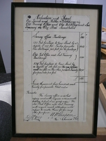
Document - VALUATION AND REPORT ON LAND AND PUBLIC BUILDINGS, 1888
Framed document, valuation and report on land and public buildings vis old survey office and Post Office and sub Treasury in View Street Sandhurst, hand written in black ink and signed N P Simpson Feby 22nd 1888. Under glass in a thin black wooden frame.document, certificate, public buildings -
 Bendigo Historical Society Inc.
Document - SURVEY PLAN OF HARGREAVES & HOPETOWN STREETS
Undated survey plan by William Bockli, Consulting Engineer 422-428 Collins St Melbourne showing land between Hargreaves St and Hopetoun St Bendigo, stamped 'Hanro Aust Bendigo Knitting Mill, PTY,LTD., Job 37, drawing No 8. Scale . 30 feet to an inch. Unknown donorbendigo, industry, hanro knitting mill -
 Port Melbourne Historical & Preservation Society
Plan - Proposed land sub-division, west of railway, Sandridge, 19 Nov 1866
1866 plan of proposed sub-division of land at Sandridge, west of railway. Includes manure depot.J. Noone (Photolithographer, Dept. of Lands and Survey) J. Hardy (Assistant Surveyor)town planning, town planning - proposals shelved, j noone, j hardy -
 Women's Art Register
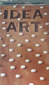
Book - Anthology, Gregory Battcock, Idea Art, 1973
A survey of theories, practices and documents that outlines the origins of US and European Idea Art of the 1960s and 1970s.non-fictionA survey of theories, practices and documents that outlines the origins of US and European Idea Art of the 1960s and 1970s.idea art, land art, conceptual art, lucy lippard, dore ashton, jonathan benthall, cheryl bernstein, jack burnhan, joseph kosuth, ursula meyer, john perreault, arthur rose, harold rosenberg, seth siegelaub, sol le witt, lawrence weiner, daniel buren, mel bochner, robert hughes -
Port Melbourne Historical & Preservation Society
Letter - Office of Lands & Survey re permission to build a boat on Sandridge Beach, Secretary for Lands, 22 Jun 1876
Photo\copies of letter and small map from Office of Lands & Survey, 22 June 1876. Re permission to lease land to build a boat on Sandridge Beach. Original letter sent to J.C. Lowrie of Stokes Street. Various copies stapled together.local government - borough of sandridge, j c lowrie, sandridge beach -
Port Melbourne Historical & Preservation Society
Letter - Lands & Survey Office re land for football ground, 19 Apr 1880
... Lands & Survey Office re land for football ground...Letter from Lands & Survey Office regarding land... & Survey Office regarding land for football ground, 1880 Letter ...Letter from Lands & Survey Office regarding land for football ground, 1880sport - australian rules football, sport - recreational grounds, peter gallienne grut, port melbourne football club, pmfc -
Port Melbourne Historical & Preservation Society
Letter - Lands & Survey Office re permission to use land for football ground, 13 May 1880
Letter from Lands & Survey Office granting permission for use of land as per tracing sheet for football ground, 1880sport - australian rules football, sport - recreational grounds, peter gallienne grut, port melbourne football club, pmfc -
Port Melbourne Historical & Preservation Society
Plan - Football Ground, Department of Survey & Lands, 13 May 1880
Plan for Football Ground on land being granted by Department of Survey & Lands, 1880sport - australian rules football, sport - recreational grounds, j kitchen & sons pty ltd, port melbourne football club, pmfc -
Port Melbourne Historical & Preservation Society
Letter - Department of Lands and Survey granting land for temporary reserve, 18 Mar 1860
... Department of Lands and Survey granting land for temporary...Handwritten letter from Dept of Lands and Survey granting... Dept of Lands and Survey granting Crown land for temporary ...Handwritten letter from Dept of Lands and Survey granting Crown land for temporary reserve as site for abattoirs 18 March 1861local government - borough of sandridge, industry - noxious, department of lands and surveys, clement hodgkinson -
 Bendigo Historical Society Inc.
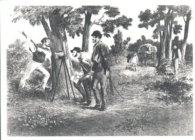
Photograph - WES HARRY COLLECTION: SURVEY PARTY, 1854
Photograph of a drawing depicting a survey party in 1854. In the left foreground there are Two men, one is looking through a theodolite and another is blazing a mark on to a tree with an axe. Two other men are dragging a chain measure. In the background there is a boy standing by a horse and cart. The whole group is in a bush land setting.organization, lands and survey, original survey, surveying, theodilite, chain -
 Bendigo Historical Society Inc.
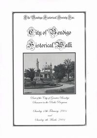
Book - CITY OF BENDIGO HISTORICAL WALK BOOK, 2001
Photocopy mock up of original booklet of The Bendigo Historical Society Inc. 'City of Bendigo Historical Walk' containing photographs of historic buildings to be seen on the walk. Front cover Queen Victorian Gardens, Town hall, Mechanics Institute/School Of Mines and Industry, H. M. Prison Bendigo, Camp Hill Police Barracks, Sandhurst Corporate High School, Central State School No. 1976, The Cascades, District Lands Office (Dudley House), Masonic Temple and Hall, Sandhurst Volunteer Rifle Brigade Orderly Room, Bank of Victoria, Henry Jackson's Store View Point,Alexandra Fountain, Beehive Store/Mining Exchange, Colonial Bank. Hustlers Royal Reserve NO. 2/R.S.L. Memorial Hall, Post Office 3rd 4th and final, Bendigo Law Courts, Shamrock Hotel 2nd and another view. Important Bendigo Dates; 1851, April gold discovered at Golden Square by Margaret Kennedy,1851 Approx. 200,000Troy oz. of gold found in Bendigo, 1852 475,857 Troy oz. Gold for the year, 1853 November 31st Bendigo Hospital admits first patient,1853 December 9th Bendigo Advertiser first issue printed, 1854 First Land Sales and streets are surveyed and named for the first time, 1854 Census of Bendigo showed 15,480 residents plus 4,000 Chinese, 1855 Sandhurst Municipal District formed, 1861 Sandhurst Proclaimed a Town. 1862 Railway to Melbourne opened, 1867 Visit by His Royal Highness the Duke of Edinburgh, 1871 July 21st Sandhurst proclaimed a City, 1881 Population of Sandhurst 14,577 residents, 1882 First telephone communications introduced, 1890 Electric trams (battery) commenced running, 1891 May 18th City of Sandhurst changes its name to City of Bendigo.book, bendigo, buildings, historic -
 Bendigo Historical Society Inc.
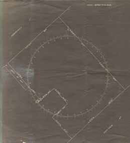
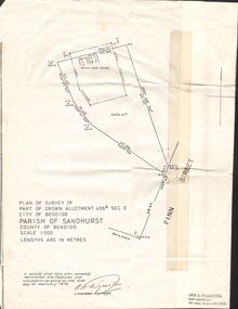
Document - CROWN ALLOTMENT 406A (PLAN) JOSS HOUSE
Plan of Survey of part of Crown Allotment 406A Sec E. City of Bendigo. Parish of Sandhurst. County of Bendigo. Scale 1:500. (Copy of Original). As at 21 February 1979. This survey shows the location of the Joss House and the portion of land where it is located.plan, bendigo, joss house, crown allotment 406a (plan), joss house -
 Victorian Interpretive Projects Inc.
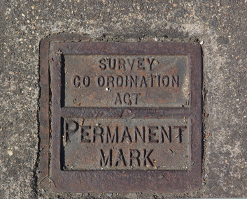
Photograph - Colour, Ballarat Survey Permanent Mark
... to enable them to plot land accurately. Ballarat survey surveyor ...A survey Permanent Mark was used by surveyors to enable them to plot land accurately.A colour photograph of a metal mark in the footpath on the corner of Ballarat's Sturt Street and Doveton Street. The Permanent Mark was put in place as part of the Survey Co ordination Act ballarat, survey, surveyor, footpath, infrastructure -
 National Vietnam Veterans Museum (NVVM)
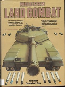
Book, Miller, David and Foss, Christopher F, Modern Land Combat, 1987
The organisation of this book follows the established style of the successful series of which if forms part. In combination with the earlier titles devoted to Modern Air Combat, Modern fighting Helicopters, Modern Naval Combat and Modern Submarine Warfare, it completes a detailed, graphically illustrated survey of the technology, hardware and tactics involved in all the main areas of current military activity.The organisation of this book follows the established style of the successful series of which if forms part. In combination with the earlier titles devoted to Modern Air Combat, Modern fighting Helicopters, Modern Naval Combat and Modern Submarine Warfare, it completes a detailed, graphically illustrated survey of the technology, hardware and tactics involved in all the main areas of current military activity.military art and science, weapons -
 City of Whittlesea
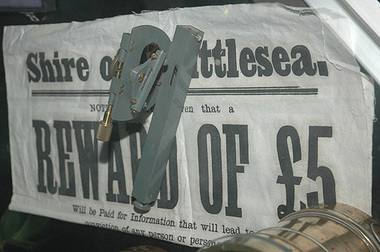
Instrument - Surveying instrument, Clinometer
... melbourne Clinometer- used for measuring the slope of the land ...Clinometer- used for measuring the slope of the landMetalsurveying equipment -
 St Kilda Historical Society
Photograph - Photo map, 28/01/1951
One of a series of photo-maps produced for the Department of Crown Lands and Survey (1857-1983). For correlation with a current map, and access to other historical photo maps of Victoria, see the Historic Photo-Maps Index published by the Department of Environment, Land, Water and Planning at https://services.land.vic.gov.au/DELWPmaps/historical-photomaps/Black and white aerial photograph1424-45 SECRET 534 Run 18 Lens 12" Melbourne Metropolitan 12150 28.1.51 M639albert park, st kilda junction, st kilda pier, catani gardens, st kilda, prahran, albert park lake, 1951, middle park, st kilda beach, windsor -
 St Kilda Historical Society
Photograph - Photo map, 17/01/1951
One of a series of photo-maps produced for the Department of Crown Lands and Survey (1857-1983). For correlation with a current map, and access to other historical photo maps of Victoria, see the Historic Photo-Maps Index published by the Department of Environment, Land, Water and Planning at https://services.land.vic.gov.au/DELWPmaps/historical-photomaps/Black and white aerial photograph1414-21 538 Run 19 Lens 12" Melbourne Metropolitan 12150 17.1.51 M586st kilda, st kilda botanical gardens, peanut farm, elwood, 1951, point ormond, elwood canal, st kilda beach -
 St Kilda Historical Society
Photograph - Photo map, 28/01/1951
One of a series of photo-maps produced for the Department of Crown Lands and Survey (1857-1983). For correlation with a current map, and access to other historical photo maps of Victoria, see the Historic Photo-Maps Index published by the Department of Environment, Land, Water and Planning at https://services.land.vic.gov.au/DELWPmaps/historical-photomaps/Black and white aerial photograph1424-118 534 Run 20 Lens 12" Melbourne Metropolitan 12150 18.1.51M639elwood, point ormond, elwood park, elsternwick park, elwood beach, 1951 -
 St Kilda Historical Society
Photograph - Photo map, 17/01/1951
One of a series of photo-maps produced for the Department of Crown Lands and Survey (1857-1983). For correlation with a current map, and access to other historical photo maps of Victoria, see the Historic Photo-Maps Index published by the Department of Environment, Land, Water and Planning at https://services.land.vic.gov.au/DELWPmaps/historical-photomaps/Black and white aerial photograph1414-20 538 Run 19 Lens 12" Melbourne Metropolitan 12150 17.1.51 M586elwood, elsternwick, st kilda east, balaclava, ripponlea, 1951 -
 St Kilda Historical Society
Photograph - Photo map, 28/01/1951
One of a series of photo-maps produced for the Department of Crown Lands and Survey (1857-1983). For correlation with a current map, and access to other historical photo maps of Victoria, see the Historic Photo-Maps Index published by the Department of Environment, Land, Water and Planning at https://services.land.vic.gov.au/DELWPmaps/historical-photomaps/Black and white aerial photograph1424-44 534 Run 18 Lens 12" Melbourne Metropolitan 12150 28.1.51 M639 -
 St Kilda Historical Society
Photograph - Photo map, 28/01/1951
One of a series of photo-maps produced for the Department of Crown Lands and Survey (1857-1983). For correlation with a current map, and access to other historical photo maps of Victoria, see the Historic Photo-Maps Index published by the Department of Environment, Land, Water and Planning at https://services.land.vic.gov.au/DELWPmaps/historical-photomaps/Black and white aerial photograph1424-43 534 Run 18 Lens 12" Melbourne Metropolitan 12150 28.1.51 M639armadale, malvern, st kilda cemetery, caulfield north, st kilda east, 1951 -
 St Kilda Historical Society
Photograph - Photo map, 30/01/1960
One of a series of photo-maps produced for the Department of Crown Lands and Survey (1857-1983). For correlation with a current map, and access to other historical photo maps of Victoria, see the Historic Photo-Maps Index published by the Department of Environment, Land, Water and Planning at https://services.land.vic.gov.au/DELWPmaps/historical-photomaps/Black and white aerial photographVic 1093-62 Melbourne & Metropolitan Project Run 21 30.1.60 Lens 10" 8.200middle park, albert park, catani gardens, st kilda west, 1960 -
 St Kilda Historical Society
Photograph - Photo map, 30/01/1960
One of a series of photo-maps produced for the Department of Crown Lands and Survey (1857-1983). For correlation with a current map, and access to other historical photo maps of Victoria, see the Historic Photo-Maps Index published by the Department of Environment, Land, Water and Planning at https://services.land.vic.gov.au/DELWPmaps/historical-photomaps/Black and white aerial photographVic 1093-60 Melbourne & Metropolitan Project Run 21 30.1.60 Lens 10" 8.200st kilda, albert park, prahran, windsor, south yarra, 1960 -
 St Kilda Historical Society
Photograph - Photo map, 30/01/1960
One of a series of photo-maps produced for the Department of Crown Lands and Survey (1857-1983). For correlation with a current map, and access to other historical photo maps of Victoria, see the Historic Photo-Maps Index published by the Department of Environment, Land, Water and Planning at https://services.land.vic.gov.au/DELWPmaps/historical-photomaps/Black and white aerial photographVic 1092-36 Melbourne & Metropolitan Project Run 22 30.1.60 Lens 10" 8.200st kilda, st kilda pier, st kilda beach, catani gardens, 1960 -
 St Kilda Historical Society
Photograph - Photo map, 30/01/1960
One of a series of photo-maps produced for the Department of Crown Lands and Survey (1857-1983). For correlation with a current map, and access to other historical photo maps of Victoria, see the Historic Photo-Maps Index published by the Department of Environment, Land, Water and Planning at https://services.land.vic.gov.au/DELWPmaps/historical-photomaps/Black and white aerial photographVic 1092-38 Melbourne & Metropolitan Project Run 22 30.1.60 Lens 10" 8.200st kilda, st kilda beach, st kilda pier, catani gardens, 1960, st kilda botanical gardens, peanut farm