Showing 1007 items
matching paddocks
-
 Coal Creek Community Park & Museum
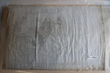
Mine Map
8518.1 - Unlabelled map of mining tunnels, coal seams, boreholes, creeks, roads and (presumably) paddock boundaries. Based on features in common with other maps, very likely map of Korumburra area. -
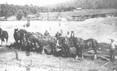 El Dorado Museum Association Inc.
Photograph (item) - Digital Image
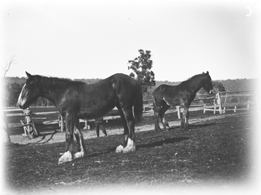
Horse team , Cocks Pioneer Cocks Pioneer Electric Gold & Tin Mine Company was formed in 1899. The company's first power station, located at the eastern end of the valley began operating with its 340 Kilowatt steam-powered generator. By 1909, from 2,500,000 cubic yards worked, reported recovery was 17 284 ounces of gold and 224 tons of tin ore. By 1909, Cocks Pioneer’s power plant had become inadequate and uneconomical. The barge was floated downstream about a mile, but lost time caused the operations to cease. Following testing, a new mine was established by diverting Reid's Creek at a cost of £25,000. Settling dams were built, one of which held 1,935,900 cubic feet. Sold earth banks, built against a wall of stringy bark saplings constructed and laced with vertical props, were built. In 1914, the company was reformed as Cock’s Pioneer Gold and Tin Mines NL, another power station was constructed at the western end of the township, near the junction of Clear and Reid's Creeks. From 6,800,000 cubic yards of material processed, the returns were 64,397 ounces of gold and 855 ton of tin. Cocks Pioneer mine then moved the barge downs stream and continued sluicing. In 1929 Cocks Pioneer Electric Gold and Tin Mining Company ceased operations due to a drop in values. Cock’s Pioneer Gold and Tin Mines NL carried on large-scale hydraulic sluicing operations until 1941. mining, gold, tin, sluicing, men, cocks pioneer, el dorado, eldorado, horses, gold mining, tin mining -
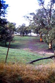 Greensborough Historical Society
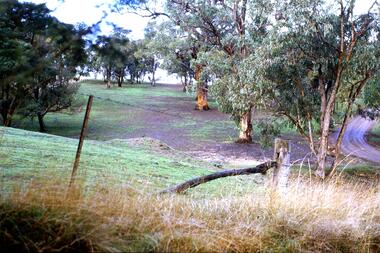
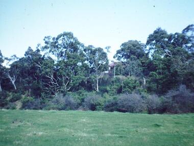
Slide - Photograph, John Ramsdale, Erosion on overgrazed property: Slide 125, 1990s
Photograph shows a fenced paddock and gum trees; erosion on overgrazed property near Whittlesea.Part of the John Ramsdale collection of slides and audio visual material.Colour photograph scanned from slide.No maker's marks. No caption on slide.whittlesea, erosion, farming -
 National Wool Museum
Book, The Top Paddock
"The Top Paddock" by Nigel Austin, 1987. History of the Collinsville Merino Stud in South Australia.merino sheep - history, collinsville merino stud pty ltd -
 Southern Sherbrooke Historical Society Inc.
Photograph - Belgrave
B&W photo of a scene in Belgrave, taken Easter 1922 presumably by Miss Field. The view is downhill towards a paddock surrounded by trees. There is a cluster of perhaps half a dozen animals which may be cows or horses They are standing near fencing. There appears to be a building further down the slope and possibly another building to the right of the paddock. On the treed hills in the background another two or so buildings are visible. On the back of the photo 'Belgrave Easter 1922' is written in pen. -
University of Melbourne, Burnley Campus Archives
Plan, Como, 1983, 1993
(1) Como Plant Inventory: Rear of House - Big Pond Lawn, Fountain Terrace and The Paddock dated November 1983, Landform Australia - photocopy in 2 sheets. Numbered list of plants and placement. (2) 2 copies Blueprint - Automatic Watering System Legend by Planned Irrigation Projects Pty. Ltd. (3) Tracing paper and paper plans of Croquet Lawn and Pony Paddock 'Como', Como Avenue, South Yarra - Landscape Studies Assignment 1993.como house, plant inventory, south yarra, irrigation -
 Greensborough Historical Society
Slide - Photograph, John Ramsdale, Erosion on overgrazed property: Slide 124, 1990s
Photograph shows a fenced paddock and gum trees; this is sheet erosion on an overgrazed property near Whittlesea.Part of the John Ramsdale collection of slides and audio visual material.Colour photograph scanned from slide.No maker's marks. No caption on slide.whittlesea, erosion, farming -
 Dookie Historical Society
Storekeeper Book, DOOKIE SUPPLY STORES-DOCKET BOOK. 1911, 1911
Includes documentation of the ploughing of the Wunghu Church paddock, (Miss Maggie Maher) Other interesting entries.Docket book and activity of work items enter. Book from the Dookie Supply Stores -
 Federation University Historical Collection
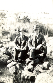
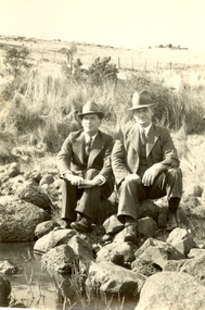
Photograph - Black and White, Frank Wright and Charlie, Smeaton, 1940, March 1940
Frank Wright was a renown resident of Smeaton, where he was born on 2 August 1901. He lived at Laura Villa, and attended Smeaton State School. His father William was a gold miner and his mother's name was Sarah. Their family won many singing and instrumental awards. Frank was tutored by Percy Code and was awarded a gold medal for the highest marks in the ALCM examinations in the British Colonies at the age of seventeen years. He became the Australian Open Cornet Champion by the age of eighteen. A year later, Frank conducted the City of Ballarat Band, and later the Ballarat Soldiers’ Memorial Band. He formed the Frank Wright Frisco Band and Frank Wright and his Coliseum Orchestra. These bands won many South Street awards, and Frank as conductor won many awards in the Australian Band Championship contest. In 1933 Frank Wright sailed to England to conduct the famous St Hilda’s Band and was later appointed Musical Director of the London County Council, where he organized many amazing concerts in parks, in and around the London district. He was made Professor of Brass and Military Band Scoring and conducted at the Guildhall of Music and Drama. Frank was often invited to adjudicate Brass Band Championships around Europe, in Australia, including South Street and in New Zealand. The Frank Wright Medal at the Royal South Street competition is awarded to an individual recognized as making an outstanding contribution to brass music in Australia.Black and white photograph of two men dressed in suits and hats, sitting on rocks beside water. The background is a grassy paddock with a post and wire fence in the far distance. The man on the left is Frank Wright.Written in pencil on back - F.W. & Charlie, Smeaton, March 1940frank wright, brass band, conductor, smeaton -
 Federation University Historical Collection
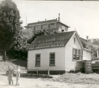
Photograph - black and white, Ballarat School of Mines Caretaker's Cottage, 1955, 03/1955
Black and white photograph of the small weatherboard building in the grounds of the Ballarat Junior Technical School's sport ground, known as the Battery Paddock. In the background is the south end of the Ballarat Junior Technical School building. ballarat school of mines caretaker, caretaker's cottage, ballarat junior technical school, battery paddock -
 Bendigo Historical Society Inc.
Photograph - CASTLEMAINE GAS COMPANY COLLECTION: PHOTO PADDOCK, 20/07/1999
Photo of a paddock, sign ''Caution gas main'' at the centre, on the right hand side a road and on the left a fence and a power pole. Date stamp at bottom left 20/07/1999. location unknown.Kodakplace, land, paddock -
Port Melbourne Historical & Preservation Society
Sign - "Please do not park here", Station Pier, Port Melbourne, c. 1950
SIGN IS NOT TO LEAVE PORT MELBOURNE White background, black hand-lettered sign from Station Pier "Please do not park here. Large trucks use this area to manouvre into paddock opposite"port of melbourne authority, piers and wharves - station pier -
Tatura Irrigation & Wartime Camps Museum
Photograph, Cattanach Canal, 1957
Taken by the photographer for Victoria State Rivers and Water Supply Commission.Large sepia photograph - Construction equipment middle foreground, two bridges, truck crossing second bridge, trees, flat paddock, scattered trees, man working on nearer concrete bridge support.Below photo: "Cattanach Canal / Rail and Highway Bridges near Murchison"irrigation, victoria state rivers and water supply commission, cattanach canal, bridges -
Whitehorse Historical Society Inc.
Letter - Correspondence, Mason's Paddock, 1937
Letter from Holmes & Glide, Auctioneer acting as executor of Estate, Late J. Payne to Shire of Blackburn and Mitcham noting interest in purchasing Lot 5 Mason's Paddock, Blackburn Road, Blackburn.Letter from Holmes & Glide, Auctioneer acting as executor of Estate, Late J. Payne to Shire of Blackburn and Mitcham noting interest in purchasing Lot 5 Mason's Paddock, Blackburn Road, Blackburn.Letter from Holmes & Glide, Auctioneer acting as executor of Estate, Late J. Payne to Shire of Blackburn and Mitcham noting interest in purchasing Lot 5 Mason's Paddock, Blackburn Road, Blackburn.blackburn road, blackburn, masons paddock, shire of blackburn and mitcham, payne, j -
 Whitehorse Historical Society Inc.
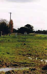
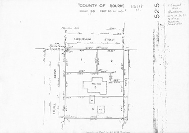
Map, Laurel Grove, 1959
Plan of subdivision, part of Crown Portion 84, Lots 29, 30, 31 Kings Paddock subdivision, cnr Laurel Grove and Laburnum Street, Blackburn. Ref 2713, 6/2/1959.laurel grove, blackburn, laburnum street, land subdivision, kings paddock -
 Ballarat Heritage Services
Photograph - Photograph - Black and White, Alice Gervasoni in front of the Old Stone House, Yandoit Creek
The Gervasoni farm at Yandoit Creek was selected in the 1860s by a coopertaive comprising Caro Gervasoni, Luigi Gervasoni, Ambrogio Invernizzi and Battista Nani.Alice Gervasoni stands in front of an old stone house in Yandoit Creek, in a paddock of stooked hay. The house was built by a partnership between Carlo Gervasoni, Luigi Gervasoni, Antonio Invernizzi and Battista Nani.alice gervasoni, luigi gervasoni, carlo gervasoni, battista nani, ambrogio invernizzi, hay, hay stook, stone house, drystone, farm, agriculture -
 Kew Historical Society Inc
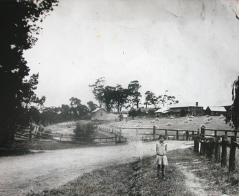
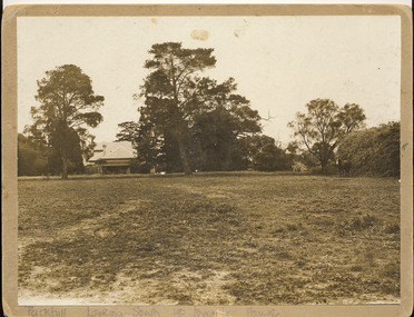
Photograph, 'Parkhill', Kew
This is the earliest known photograph of the home of Thomas Judd, now situated at 20 Hillcrest Avenue, but with an address in Parkhill Road before surrounding subdivisions were created. Thomas Judd was a notable early colonist in Kew.Silver albumen photograph on card of the house and paddock of Parkhill, the home of the Kew pioneer Thomas Judd. The photograph looks south up towards the house. The photograph is undated but it is presumed to predate the subdivision of 1915."Parkhill. Looking South up towards House"thomas judd, kew - history of, parkhill, kew -- pioneers -
Canterbury History Group
Ephemera - Payne's Paddock, Canterbury, 1918
Copy of the original brochure for the auction on 28th September 1918, of the78 building sites comprising Payne's Paddock by W.F. Vale and Co. Auctioneers. Reproduced by Sinclair and Co. to advertise their market appraisal of the area.paynes paddock, canterbury, highfield road, leura street, payne street, tyndall street, keneally street, w.f.vale and co., sinclair and co., land subdivision -
 Wodonga & District Historical Society Inc
Negative - Haeusler Glass Negatives Collection - Two horses in a paddock
The Wodonga Historical Society Haeusler Collection provides invaluable insight into life in late nineteenth and early twentieth century north east Victoria. The collection comprises manuscripts, personal artefacts used by the Haeusler family on their farm in Wodonga, and a set of glass negatives which offer a unique visual snapshot of the domestic and social lives of the Haeusler family and local Wodonga community. The Haeusler family migrated from Prussia (Germany) to South Australia in the 1840s and 1850s, before purchasing 100 acres of Crown Land made available under the Victorian Lands Act 1862 (also known as ‘Duffy’s Land Act’) in 1866 in what is now Wodonga West. The Haeusler family were one of several German families to migrate from South Australia to Wodonga in the 1860s. This digital image was produced from one of the glass negatives that form part of the collection, probably taken by Louis Haeusler (b.1887) with the photographic equipment in the Wodonga Historical Society Haeusler Collection.This item is unique and has well documented provenance and a known owner. It forms part of a significant and representative historical collection which reflects the local history of Wodonga. It contributes to our understanding of domestic and family life in early twentieth century Wodonga, as well as providing interpretative capacity for themes including local history and social history.Digital image created from the Haeusler Glass negative collection. Two horses standing in a paddock which is surrounded by wooden rail fences. The horses could be on the McKoy family horse stud farm.wodonga pioneers, haeusler family, glass negatives, dry plate photography, wodonga families -
 Clunes Museum
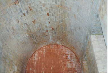
Photograph, KODAK, 1999
VIEW OF POWDER MAGAZINE USED IN MINING DAYS TO STORE EXPLOSIVES. BUILDING MATERIALS SOLID BRICKCOLOURED REPRINT PHOTOGRAPH OF POWDER MAGAZINE EXTERIOR. SITUATED IN A PADDOCK ON SMEATON ROAD APPROX. 2 KM. FROM TOWNSHIP ON LEFT HAND SIDE. SHOWING BRICKED ARCHED ROOF AND END WALL.photography, photographs, mining, powder magazine -
 Greensborough Historical Society
Photograph - Digital image, Frank Robinson, Greensborough from Pope's paddock, 1956_
Greensborough from Pope's paddock. Pope's paddock was across the Plenty River from Blackjack. The Blackjack property, house and acres of fruit orchards ran down to the Plenty River off Hume Street Greensborough and was the home of the Robinson family to late 1956. The photographs were taken as slides by Frank Robinson and digitised by his son James in 2015.Digital copy of colour photograph.blackjack, robinson family, popes paddock -
 Tatura Irrigation & Wartime Camps Museum
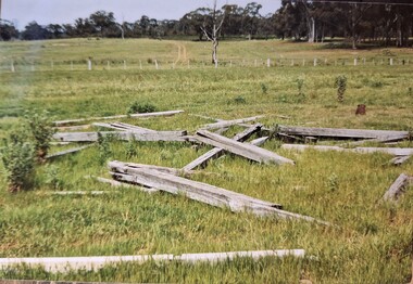
Photograph, Arthur Knee, Guard tower ruins camp 13, 1989
Camp 13 guard observation tower beams (ruins) in paddock. Timber and wire fence mid distance.Camp 13, Camp Road, Murchison, Victoria. Timber beams, remnants of guard observation tower (foreground).camp 13, internment camp, murchison victoria, observation tower, ruins, guard tower ruins -
City of Kingston
Photograph - Black and white, 20 December 1945
This aerial image covers a section of Cheltenham, with a large paddock yet to be converted to an industrial and later a commercial zone.This aerial photograph provides evidence of the changing landscape of Cheltenham and Highett since WWII. Photographed in 1945, the image features a large block of land now the site of site the major transformation of Cheltenham with the development of the Southland shopping centre in the 1960s and expansion in the 1990s.Aerial photograph of the Cheltenham area in the City of Kingston. This 1945 image is concentrated on the area between Bay Road and Garfield Lane with the distinctive bend into Jean Street. A large block of land runs between the Nepean Highway and the rail line. This is now the area occupied by the extension of Southland in the 1990s.cheltenham, southland, aerial photograph, highett -
City of Kingston
Photograph - Black and white, 20 December 1945
This aerial image covers a section of Cheltenham, with a large paddock yet to be converted to an industrial and later a commercial zone.This aerial photograph provides evidence of the changing landscape of Cheltenham and Highett since WWII. Photographed in 1945, the image features a large block of land now the site of site the major transformation of Cheltenham with the development of the Southland shopping centre in the 1960s and expansion in the 1990s.Aerial photograph of the Cheltenham area in the City of Kingston. This 1945 image is concentrated on the area between Bay Road and Garfield Lane with the distinctive bend into Jean Street. A large block of land runs between the Nepean Highway and the rail line. This is now the area occupied by the extension of Southland in the 1990s. It is a negative version of VKHC124.cheltenham, southland, market garden -
 Federation University Historical Collection
Photograph - Black and White, Frank Wright and Friend, circa late 1920's
Frank Wright was a renown resident of Smeaton, where he was born. He lived at Laura Villa, and attended Smeaton State School. His father William was a gold miner and his mother's name was Sarah. Their family won many singing and instrumental awards. Frank was tutored by Percy Code and was awarded a gold medal for the highest marks in the ALCM examinations in the British Colonies at the age of seventeen years. He became the Australian Open Cornet Champion by the age of eighteen. A year later, Frank conducted the City of Ballarat Band, and later the Ballarat Soldiers’ Memorial Band. He formed the Frank Wright Frisco Band and Frank Wright and his Coliseum Orchestra. These bands won many South Street awards, and Frank as conductor won many awards in the Australian Band Championship contest. In 1933 Frank Wright sailed to England to conduct the famous St Hilda’s Band and was later appointed Musical Director of the London County Council, where he organized many amazing concerts in parks, in and around the London district. He was made Professor of Brass and Military Band Scoring and conducted at the Guildhall of Music and Drama. Frank was often invited to adjudicate Brass Band Championships around Europe, in Australia, including South Street and in New Zealand. The Frank Wright Medal at the Royal South Street competition is awarded to an individual recognized as making an outstanding contribution to brass music in Australia.Black and white photograph of two men dressed in suits and hats, sitting on rocks beside a creek in a grassy paddock, with a post a wire fence in the background. The man on the left is Frank Wright. The man on the right is unknown.Printed on back - SELOfrank wright, ballarat, cornet, conductor, smeaton -
 Bendigo Historical Society Inc.
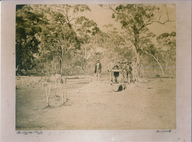
Photograph - MYERS CREEK DIGGINGS, c1867
Sepia Photograph: Myer's Creek Diggings 'Bachelder Photo Sandhurst'. 6 male 'Diggers' gathered around a windlass at a mine opening amongst the trees in a paddock. Inscription Markings: Myers Creek Diggings 1867place, mining site, myer's creek diggings -
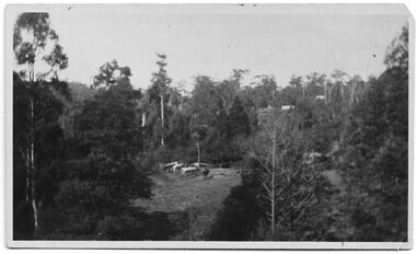
 Hume City Civic Collection
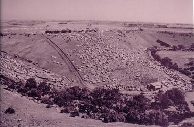
Photograph, 1972
The photograph was taken during the 1972 Sunbury Pop Festival which was staged on a property owned by George Duncan. The site is on the banks of the Jacksons Creek between Sunbury and Diggers Rest.An aerial photograph of a crowd of people on a hillside and along a creek valley with a stage set up. On the LHS there is a large marquee surrounded by cars and pitched tents. There are trees around the creek and vast open paddocks in the distance.sunbury pop festival, jacksons creek, duncan, george, george evans collection -
 Whitehorse Historical Society Inc.
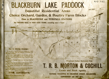
Document, Blackburn Lake Paddock
Brochure of Blackburn Lake Paddock consisting of 23 residential areas,Brochure of Blackburn Lake Paddock consisting of 23 residential areas, orchard, garden and poultry farm. Bounded by railway to Lilydale, Central Road, Lake Road, Springvale Road and close to Blackburn and Tunstall Stations.Brochure of Blackburn Lake Paddock consisting of 23 residential areas,t. r. b. morton & coghill, johnstone & tait, mccarron bird & co., blackburn lake paddock, central road, blackburn, lake road, springvale road, nunawading -
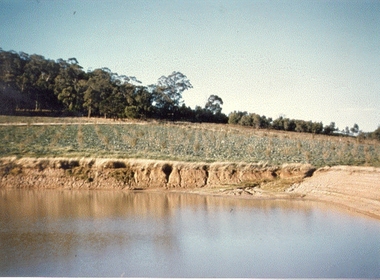 Southern Sherbrooke Historical Society Inc.
Photograph - The dam, Montague Orchards
Colour photo of the dam at Montague Orchards in Narre Warren North. Photo shows a partially filled dam with dug-out sides, a paddock with planted rows of glaucous green plants, and beyond that is bushland on a ridgeline. -
Kew Historical Society Inc
Archive (Sub-series) - Subject File, Kew Historical Society, Hays Paddock (Kew East), 1958
Various partiesReference, Research, InformationSecondary Values (KHS Imposed Order)Subject file containing many newspaper/magazine articles/clippings (1979-2016), some published by the City of Boroondara, and maps, summaries of reports (KNews, 1980) and proposals to create an ‘integrated playground’ at Hays Paddock.kew historical society - archives, hays paddock - kew east (vic), parks and gardens - kew east (vic)kew historical society - archives, hays paddock - kew east (vic), parks and gardens - kew east (vic)