Showing 12317 items
matching railway
-
 Kew Historical Society Inc
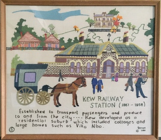
Textile - Bicentennial tapestry, 5. Kew Railway Station (1887-1958), 1988
This is one of eight embroidered panels, completed during the 1988 Australian Bi-Centennial, and carried out under the auspices of City of Kew Council and the Kew Historical Society. Nearly 600 residents, including many children, participated in their production by adding a few or more stitches. A book records their names and the panels upon which they worked. Artist: Joy Stewart / Co-ordinator: Dorothy Benyei.5. Kew Railway Station (1887-1958). A framed embroidery created by adults and children of the City of Kew as a Bicentennial project, based on a design by the artist Joy Stewart. Other completed embroideries created in the project are/were displayed in the Kew Library. Inscription: "KEW RAILWAY STATION (1887-1958). Established to transport passengers and produce too and from the city ... Kew developed as a residential suburb which included cottages and large homes such as Villa Alba". Embroidered signature of the artist "(c) JStewart, 1988"bicentennial project (kew), joy stewart, australian bicentennial, kew railway station -
 Whitehorse Historical Society Inc.
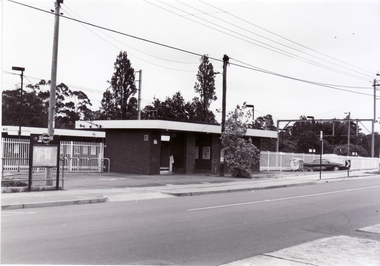
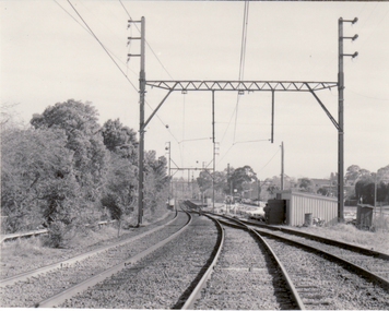
Photograph, Blackburn Railway Station, 6/01/2001 12:00:00 AM
Black and white photograph of Blackburn Railway Station looking south from Railway Road, Blackburn.blackburn railway station. -
 Whitehorse Historical Society Inc.
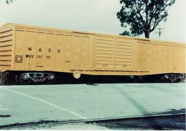
Photograph, Railway Wagon, C.1956
Railway Wagon at Mitcham Railway Station. Area now Car Park. Cross Ref. ND1837.mitcham railway station, glasson, bill -
 Phillip Island and District Historical Society Inc.
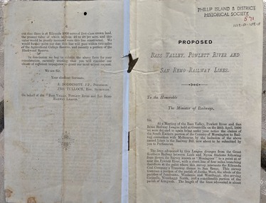
Document - leaflet, Proposed Bass Valley, Powlett River and San Remo Railway Lines
Submission for the Bass Valley, Powlett River and San Remo Railway line to be included in the Railways Act4 page paper booklet with small print. Pages 3-6. Page 1-2 appear to be missingnon-fictionSubmission for the Bass Valley, Powlett River and San Remo Railway line to be included in the Railways Actrailways, san remo, public transport, bass valley, powlett river -
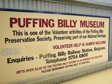 Puffing Billy Railway
Puffing Billy Museum Entry Sign, post 1994
Historic - early period - Puffing Billy Railway Museum Sign Historic - early Puffing Billy Railway Museum Sign Puffing Billy Museum Entry Sign Large painted metal Puffing Billy Museum Entry Signpuffing billy, entry sign, puffing billy museum -
 Ballarat Heritage Services
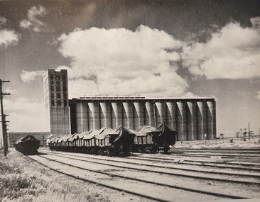
Photograph, Silos at A Railway Siding
Silos at A Railway Sidingtrain, wheat, silo, grains, silage -
 Otway Districts Historical Society
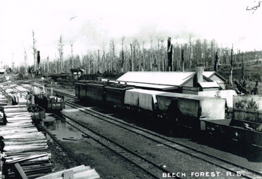
Photograph, Beech Forest railway station, carriages and wagons, c.1915
The Beech Forest railway carried very heavy loading, mostly consisting of timber, but also potatoes, lime, gravel, chaff and dairy produce. Livestock was carried and, while no dedicated passenger service operated "car-goods" ran on Monday, Wednesday and Saturday plus occasional passenger specials. However, despite the high tonnage heavy financial losses were experienced, due partly to the small amount of inbound goods and the high empty wagon mileage. Annual losses by 1915 were up to L8,000, and these were only exacerbated by increased traffic.B/W. Beech Forest Railway Station, guard's van, carriages and wagons on the right, and wagons loading with timber on the left. c.1915.beech forest; railways; station; -
![Map, Ballarat and Gordons Lane Plan of Land required [for railway line work]](/media/collectors/5e461d8021ea67224c82f2a1/items/676ff3a62c3783fe00b96a8d/item-media/676ff4a42c3783fe00b96cb6/item-fit-380x285.jpg) Bacchus Marsh & District Historical Society
Bacchus Marsh & District Historical SocietyMap, Ballarat and Gordons Lane Plan of Land required [for railway line work]
The railway line from Melbourne to Bacchus Marsh was completed in February 1887. After this date work continued to extend the line to Ballan. This map indicates a portion of land only a few hundred metres west of the Bacchus Marsh railway station which would have been among the first stages of the line to Ballan to have been constructed. This suggests the date of this map to be in the late 1880s.Single page map showing land required for railway line work near Griffith Street, Bacchus Marsh. Scale 10 chains to 1 inch. Hand-written on the map are the exact distances between Bacchus Marsh and Gordons (Gordon) and between Bacchus Marsh and Melbourne as measured from the corner of Maddingley Road and Station Street. Distances recorded are in miles, chains and links. The land required for the railway works is marked in red ink and runs through an area known as Kennedy's Gully. Part of a set of maps which are pasted into a bound volume containing 76 maps or plans in total. High resolution digital image stored on BMDHS computer network. bacchus marsh victoria history, maddingley victoria history, railway lines -
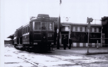
 St Kilda Historical Society
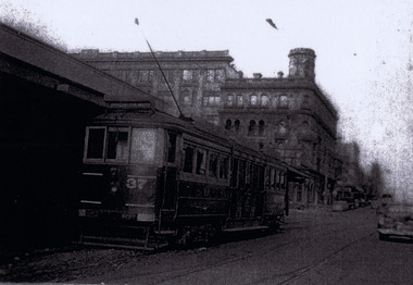
Photograph, Railway tram at St Kilda Station, c. 1950s?
George Hotel in backgroundlaminated black and white photograph (2 identical)Railway tram at St Kilda Station -
 St Kilda Historical Society
Photograph, Railway tram, c. 1958
laminated black and white photograph (2 identical)St KildaStation Railway Tram 1958 -
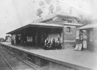 Ringwood and District Historical Society
Photograph, Ringwood Railway Station's main platform and staff in 1914, 1926
Showing main building at Ringwood Railway Station in 1914, including railway staff and newspaper shop on the platform. -
 Whitehorse Historical Society Inc.
Photograph - B/W Photograph, Railway House Mitcham
Black and white photo of Railway House Mitcham. Originally 127 Railway Road Mitcham; the official Victorian Railways residence and former home of the Bawden family and then the Hutchison Family. View of the front.bowden family, jones, shirley -
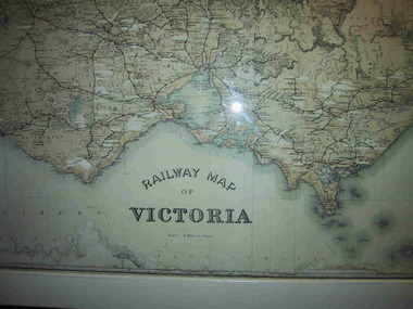 Parks Victoria - Mount Buffalo Chalet
Map, "Railway Map of Victoria"
Large framed map of Victoria, showing Victorias extensive rail network. Printed by Victorian Railways and is one of a number of 'framed pictures, particularly photographs of scenery, which have always been a feature of the Chalet.' (Pg 83. Historica, 2011) This map has been a permanent fixture situated in the hallway alongside the ballroom leading to the ski hire area since the 1950's and most likely earlier. Listed in Draft Inventory of Significant Collection ItemsLarge railway map of Victoria, Melbourne & Ballarat framed in white painted wood. Scale eight miles to one inch. Areas of the map have been whited out.Yes -
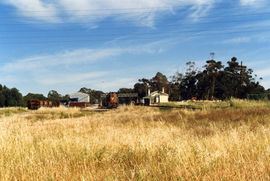 Charlton Golden Grains Museum Inc
Photograph, Charlton Shire, Charlton Railway Station c. 1987, c.1987
Charlton Railway Station was established in 1882 and closed down in the late 1970s.Colour photograph of the disused Charlton Railway Station. On the right, there is a small cream and green weatherboard building with a large verandah. There is a train engine and trucks in the middle of the photo and some other trucks to the left. There is a large corrugated iron shed and a small dark grey crane behind it. There is a large area of high grass in the foreground and six electricity wires through the top of the photo.transport, railway station, charlton -
 Ringwood and District Historical Society
Work on paper, Hand written and typed notes on Heathmont Railway Station 1889-1927 by Pat Talbot used in the book "Wielands of Heathmont"
These notes were used extensively in the book the "Wielands of Heathmont", pages 18 and 19, written by Pat Talbot and her husband Don. The notes tell how in 1922 a Railway League was formed with Herman Pump as chairman. The Wieland brothers used their horses and plough in 1926 to help build the Heathmont station. Pat was the-great -Granddaughter of Carl Wieland. The notes also include the Heathmont Information League. Short history typed and handwritten of Heathmont Railway station 1889-1927 among other notes for the Wieland history.written by Pat Talbot (nee Wieland). Large pad of note pages. -
 Whitehorse Historical Society Inc.
Article, Baby health centre|Mitcham State School No. 2904|Railway revenue at Mitcham, 1929
Three photocopied articles: Official opening of the Mitcham section of the Shire of Blackburn and Mitcham Baby Health CentreThree photocopied articles: Official opening of the Mitcham section of the Shire of Blackburn and Mitcham Baby Health Centre; Visit by Hon R.M. Cuthbertson, Assistant Minister for Education to Mitcham State School, M.L.A. Mr E.W. Greenwood; A drop in total revenue at Mitcham Railway Station.Three photocopied articles: Official opening of the Mitcham section of the Shire of Blackburn and Mitcham Baby Health Centreshire of blackburn and mitcham, maternal and child health centres, walker, edgar edwardes, cochrane, stanley, dr, barnett mrs, macartney, sister, maternal health centre, mitcham, mitcham state school, no. 2904, mitcham railway station, cuthbertson, r.m., greenwood, e. w., fenton (mr) -
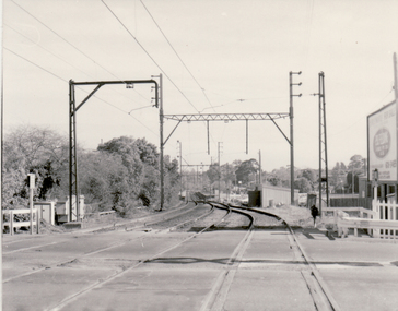 Whitehorse Historical Society Inc.
Photograph, Blackburn Railway Station, 2/08/1979 12:00:00 AM
Black and white photo of Blackburn Railway Station taken from Blackburn Road Railway Crossing looking west.blackburn railway station, railway crossing -
 Whitehorse Historical Society Inc.
Photograph, Blackburn Railway Station, 2/08/1979 12:00:00 AM
Black and white photo of Blackburn Railway Station taken from Blackburn Road Railway Crossing looking left.blackburn railway station, blackburn -
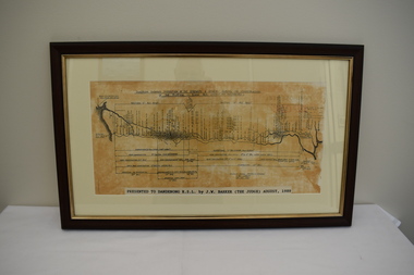 Dandenong/Cranbourne RSL Sub Branch
Map - Framed photograph, Diagram of Burma-Siam Railway
Major historical significance.Wooden framed photograph with diagram of the Railway. Illustrates the construction of the Railway. Began in October 1942 and completed on October 1943.Presented to Dandenong RSL by J. W. Barker (The Judge) August 1989. -
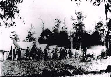 Otway Districts Historical Society
Photograph, Knox Collection, Survey camp for Colac-Beech Forest railway, 1901, 1901
Plans for a rail connection between Colac and Beech Forest had been drawn up in 1884 and 1889 but proofed inconclusive because of the enormous cost involved in building a railway in such difficult terrain. Because of the financial depression in the early 1890s such expenditure went of hold. Towards the end of the decade planners recognised that a narrow gauge could be a viable alternative and it was taken up by the community, Parliamentary representatives and the government, although Victorian Railways administration was against the idea. This was overridden. The 1898 Parliament approved a 2 foot 6 inch gauge from Colac to Beech Forest although strict financial limits were set. The route was to be the most direct and the infrastructure the most basic. Construction began in 1900 entailing very steep grades and myriad curves until it finished in 1902. Surveyors and their assistants came before and during the track laying for the whole distance.B/W. Survey camp for the Colac-Beech Forest railway in 1901, showing nine tents, ten men including a cook, survey instruments, and three bicycles. Note the cooking fire on the right.colac: beech forest; railways; survey; -
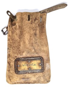 Wodonga & District Historical Society Inc
Functional object - Leather pouch and stamps - Cudgewa Railway Line
Cudgewa Line -The Cudgewa railway line opened in stages between 1889 and 1921. The first section from Wodonga to Huon opened on 10 September 1889. It was extended to Bolga on 18 July 1890, Tallangatta on 24 July 1891 and then to Shelley on 13 June 1916. Shelley was the highest station in Victoria. It extended further on to Beetomba on 10 April 1919 and finally reached Cudgewa on 5 May 1921. The line had 1 in 30 grades and trestle bridges that have been heritage listed. In 1919, the line was used to carry materials for the construction of Hume Weir, and three years later a spur line connecting Ebden to the weir was opened. In the 1960s, Cudgewa became the railhead of materials for the Snowy Mountains Scheme. The last passenger service from Wodonga to Tallangatta ran on 30 September 1961. The turntable and passenger platform at Cudgewa were abolished in 1976. These stamps were used by Joh Murray who for many years worked with Victorian Railways based at Wodonga.A leather pouch with belt and lock. It bears a metal name tag inscribed with name of railway station. The pouch contains 3 station stamps, a date stamp and 2 carriage keys.On pouch WODONGA On stamps: BONEGILLA 1470/ EBDEN 1471/ BANDOLIER 1473cudgewa rail line, victorian railways, closed victorian railways, railway stamps -
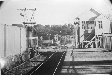 Stawell Historical Society Inc
Photograph, Railway Signal Box No.1 and a Train
Black and white photograph of Signal Box No1 and train in Stawell. Railway signal box and train stawell -
 Whitehorse Historical Society Inc.
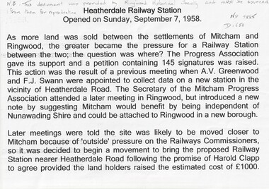
Document, Heatherdale Railway Station, 1958
History of Heatherdale Railway StationHistory of Heatherdale Railway StationHistory of Heatherdale Railway Stationheatherdale railway station, mitcham, swann -
 Ballarat Heritage Services
Image - Black and White, A Mallee Railway Station, C1905
Image of a Mallee Railway station.politician, land acts, john murray, wine, mallee -
 Whitehorse Historical Society Inc.
Photograph - B/W Photograph, Railway Parade, Blackburn
Workers at Railway Parade Blackburnrailway parade, blackburn, construction -
 Stawell Historical Society Inc
Photograph, Railway Signal Box No.1 being Demolished in Seaby Street- 2 Photos -- Coloured
Railway Signal Box No1 under Demolition situated by boom gates, Seaby Street Stawell. Photos of the demolition show workmen carrying out the work outside and inside of the signal box.Two colour photos of the demolition of wooden building. One photo is the outside of a signal box beside a railway line with a person on the roof. Windows of the building have been removed and stacked near the building. The other photo is taken inside the signal box with a person working on the building. stawell -
 Ringwood and District Historical Society
Photograph, Ringwood Railway Station, 1960
2 black and white photographs- 1 large and 1 smallWritten on rear of small photograph "Ringwood Railway Station. 1960. Picture taken from clock tower". Written on rear of large photograph, "Railway Station and railway yards from clock tower, 1960." -
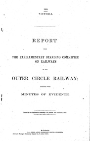 Melbourne Tram Museum
Document - Report, Victorian Parliament, "Report - The Parliamentary Standing Committee on Railways on Outer Circle Railway", Dec. 1918
Printed - 8 page foolscap, centre stapled, Victorian State Parliamentary Report titled "Report - The Parliamentary Standing Committee on Railways on the Outer Circle Railway.", together with minutes of evidence, dated 20/12/1918. Provides a history of the railway, financial results, tramway competition, fare comparison, goods traffic, Kodak and APM Developments, Railway views, committee recommendations including railway closure and dismantling.trams, tramways, outer circle railway, kew, railways, tramways, proposals, burwood -
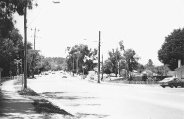 Ringwood and District Historical Society
Photograph, Railway Crossing - Bedford Rd Ringwood 1977
Black and White PhotographRailway Crossing - Bedford Rd Ringwood 1977 -
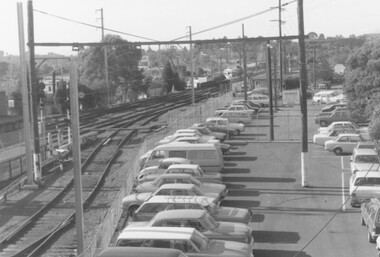 Ringwood and District Historical Society
Photograph, Ringwood Railway Yards
Black and White PhotographRingwood railway yards and car park 1984